Nearly one in five property transactions in England encounters some form of boundary ambiguity — yet the vast majority of these disputes never need to reach a courtroom. The cost of full boundary litigation can exceed £50,000 per side, drain years of goodwill between neighbours, and leave a cloud over a title that affects future saleability. Boundary and Right‑of‑Way Disputes in English Freehold Titles: How Building Surveyors and Valuers Can Work Together Before It Reaches Court is not just a legal challenge — it is primarily a technical and evidential one. When building surveyors and valuation surveyors collaborate early, they can produce the measured evidence, financial context, and expert credibility that makes out-of-court resolution not just possible, but probable.
Key Takeaways 📌
- Early technical evidence from a building surveyor — measured surveys, photographic records, and physical monument identification — is the single most powerful tool for resolving boundary disputes before litigation.
- Valuation surveyors add critical financial weight by quantifying the impact of disputed land on property value, which shapes negotiation leverage and any potential damages claim.
- The Property Boundaries (Resolution of Disputes) Bill framework allows parties to appoint agreed surveyors whose determinations are binding and registrable at HM Land Registry — avoiding court entirely. [1]
- Five root causes drive most English freehold boundary disputes: outdated surveys, physical encroachments, easement ambiguity, adverse possession, and deed-to-map inconsistencies. [6]
- Collaborative, pre-litigation surveyor involvement typically costs a fraction of court proceedings and preserves the property's marketability.
Why English Freehold Boundaries Are So Prone to Dispute
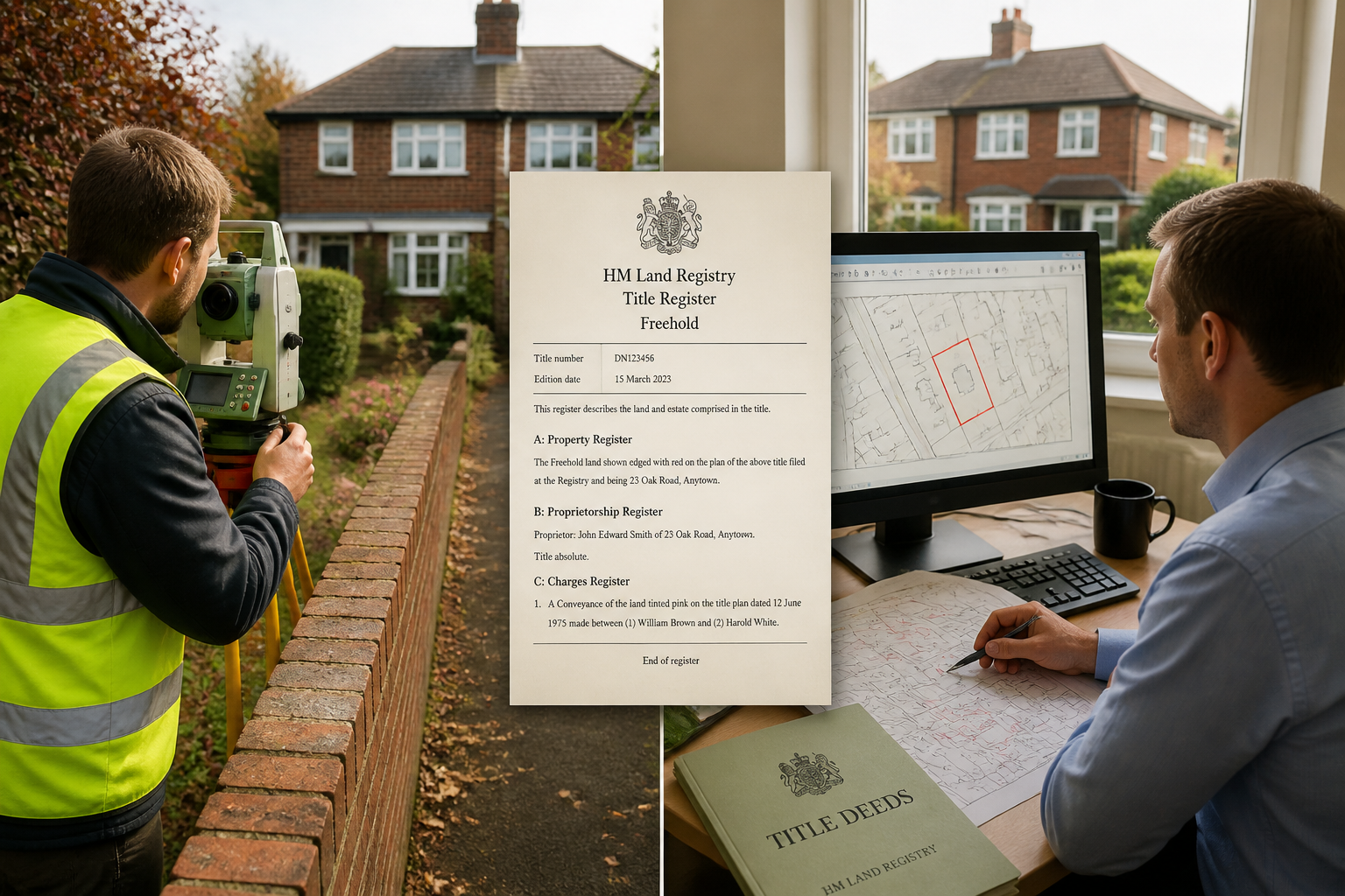
English freehold titles carry a deceptively simple promise: ownership of the land and everything above and below it. In practice, HM Land Registry title plans are drawn at 1:1250 scale, meaning a line on the plan can represent a tolerance of up to 500mm on the ground. That single fact explains why disputes erupt between neighbours who each believe they are acting entirely within their rights.
The Five Root Causes 🔍
Research into boundary and property line disputes identifies five recurring triggers [6]:
| # | Root Cause | Typical Scenario |
|---|---|---|
| 1 | Unclear or outdated surveys | Pre-1980s deeds referencing features (hedges, ditches) that no longer exist |
| 2 | Physical encroachments | A fence, extension, or outbuilding straying across the legal line |
| 3 | Easements and rights of way | Vague deed language about footpath or vehicular access rights |
| 4 | Adverse possession claims | Long-term, open use of a strip of land without challenge [6] |
| 5 | Historical deed-to-map inconsistencies | Older conveyances conflicting with modern OS mapping |
Rights-of-way disputes deserve particular attention. Insufficient or outdated documentation about access rights in property deeds is one of the primary sources of preventable conflict [3]. Under the Highways Act 1980, public rights of way — footpaths, bridleways, and byways — carry statutory protections that must be evaluated separately from private easement rights recorded in the title [4]. Confusing these two categories is a common and costly mistake.
💬 Pull Quote: "The line on a Land Registry plan is a general boundary, not a precise legal boundary. Treating it as the latter is where disputes begin."
It is also essential to distinguish between a title dispute (who owns the land?) and a boundary dispute (where exactly does ownership end?). These require different legal strategies and different types of expert evidence [5]. A building surveyor's measured survey speaks directly to the boundary question; a valuation surveyor's report addresses the financial consequence of whichever outcome prevails.
For a foundational understanding of what surveyors actually do in these contexts, the guide on what a surveyor does — roles, responsibilities and career insights provides useful background.
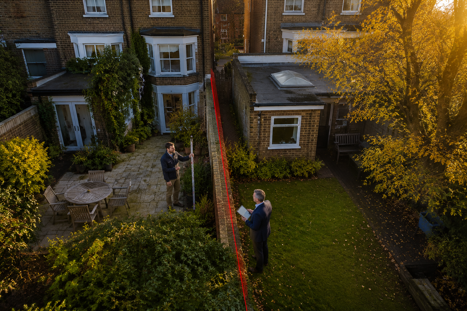
The Building Surveyor's Role: Creating the Technical Evidence Base
In Boundary and Right‑of‑Way Disputes in English Freehold Titles: How Building Surveyors and Valuers Can Work Together Before It Reaches Court, the building surveyor is the first responder. Their job is to establish objective, measurable fact before positions harden and legal costs escalate.
What a Measured Survey Achieves
A properly conducted measured boundary survey will typically include:
- Total station or GPS traversal to fix the positions of physical features (walls, fences, hedge centres, kerb lines) to within ±10mm
- Photographic schedule of condition documenting the current state of all boundary structures — see how a schedule of condition works in practice
- Overlay analysis comparing the measured survey against the title plan and any historical conveyance plans
- Identification of physical monuments — the legal principle that physical monuments and fixed reference points prevail over courses and distances in deed interpretation means ground evidence carries significant legal weight [2]
- Rights-of-way walkover to record the physical extent and condition of any claimed access route
This technical package becomes the evidential foundation for every subsequent conversation — whether that is a without-prejudice negotiation, a mediation, or an expert determination.
Rights-of-Way Specifics 🛤️
Road and access disputes introduce additional complexity. Where a dispute involves the centreline of a road or private track, the claimant must demonstrate by a preponderance of evidence that the route was dedicated to public use — common law does not presume ownership to the centreline of private roads [2]. A building surveyor can:
- Map the historical width of the road from aerial photography and OS historical maps
- Record current physical extent, surface type, and use patterns
- Identify any dedication markers or highway authority records under the Highways Act 1980 [4]
For owners dealing with property boundary disputes involving access tracks or shared driveways, this documentary groundwork is invaluable.
The Party Wall Dimension
Many boundary disputes are entangled with Party Wall Act 1996 obligations, particularly where a structure straddles or sits close to the legal line. Understanding the Party Wall Act 1996 and its practical implications is essential context for any building surveyor advising on a disputed boundary. The Act's surveyor-led award process offers a useful model for how technical experts can resolve disputes without judicial intervention.
For clarity on UK boundary wall rules, including who is responsible for maintenance and the presumptions about ownership, building surveyors should be familiar with the relevant guidance before advising clients.
The Valuation Surveyor's Role: Quantifying What Is Actually at Stake
A boundary dispute without a financial context is an argument about lines on paper. The valuation surveyor transforms that abstract argument into a business decision by answering the question every client is really asking: "How much does this actually matter to the value of my property?"
Valuation Evidence in Dispute Contexts
Valuation surveyors contribute in several distinct ways:
1. Diminution in value assessment
Where a disputed strip of land, access route, or encroachment affects the use or enjoyment of a property, a RICS-compliant valuation can quantify the financial loss. Courts can award monetary damages requiring one party to compensate the other for losses including diminution in property value [9]. Having this figure established early gives both parties a rational basis for settlement.
2. Marriage value analysis
A strip of land worth £2,000 in isolation may be worth £20,000 to an adjoining owner if it enables an extension, additional parking, or improved access. Identifying this marriage value early often explains why disputes are so fiercely contested — and why a negotiated settlement that shares some of that value can be more attractive than litigation.
3. Comparable evidence for easement value
Rights-of-way have a quantifiable value. A valuation surveyor can research comparable easement transactions to establish a reasonable licence fee or purchase price for formalising a disputed right of access — one of the most practical resolution tools available [8].
4. Impact on mortgage and insurability
An unresolved boundary dispute can make a property unmortgageable and uninsurable. A valuation surveyor's formal assessment of the risk — and of the property's value with and without the dispute resolved — is often the document that motivates both parties to settle promptly.
💬 Pull Quote: "When a client sees in black and white that the disputed strip adds £15,000 to their neighbour's property but only £3,000 to theirs, the calculus of litigation changes immediately."
For context on how survey findings influence negotiation, the article on average price reduction after survey illustrates how professional evidence shapes commercial decisions.
How Surveyors Can Work Together: The Pre-Litigation Collaboration Framework
Boundary and Right‑of‑Way Disputes in English Freehold Titles: How Building Surveyors and Valuers Can Work Together Before It Reaches Court works best when both disciplines operate as a coordinated team rather than in silos. Here is a practical framework:
Stage 1 — Joint Instruction and Scope Agreement
Both parties ideally instruct their respective surveyors simultaneously, agreeing a shared scope for the measured survey. Where trust permits, a single agreed surveyor can conduct the measured survey and share findings with both sides — reducing cost and eliminating the risk of competing technical evidence [1].
Stage 2 — Evidence Gathering and Exchange
| Building Surveyor Deliverable | Valuation Surveyor Deliverable |
|---|---|
| Measured boundary survey plan | Current market valuation of both properties |
| Schedule of condition for all boundary structures | Diminution in value assessment |
| Rights-of-way walkover report | Marriage value / easement value analysis |
| Historical map overlay analysis | Comparable transaction evidence |
| Photographic record | Mortgage and insurability impact report |
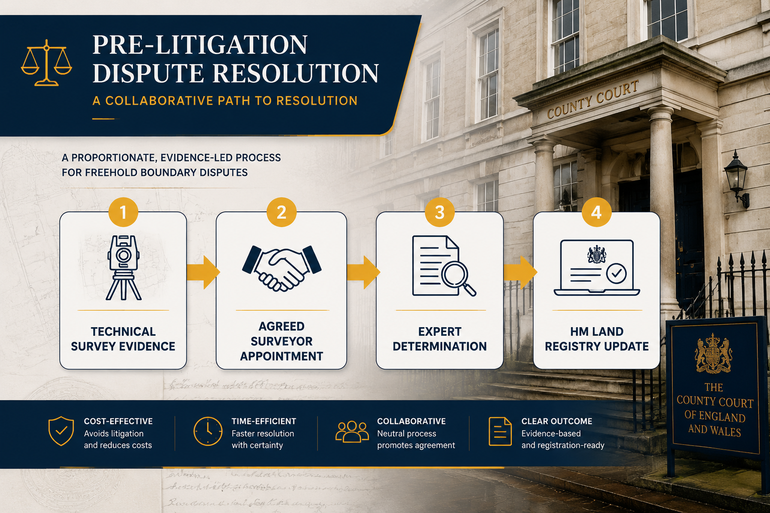
Stage 3 — Expert Determination Under the Proposed Statutory Framework
The Property Boundaries (Resolution of Disputes) Bill — modelled on the Party Wall Act 1996 — provides a structured pathway [1]:
- Parties either jointly appoint one agreed surveyor or each appoint their own, with those two selecting a third surveyor
- The appointed surveyors review all technical and valuation evidence
- A binding determination is issued
- Unless appealed to the High Court within 28 days, the award is conclusive
- The successful party submits the award to HM Land Registry within 28 days of the appeal period's expiry, and it is noted on both affected titles [1]
This process keeps the matter out of court, produces a Land Registry-registrable outcome, and typically costs a fraction of full litigation.
Stage 4 — Formalising the Resolution
Depending on the outcome, resolution may take the form of:
- A boundary line agreement recorded with HM Land Registry 📋
- An easement deed formally granting and defining a right of way [8]
- A licence agreement for ongoing access in exchange for a periodic payment
- A consent order if proceedings have already been issued but parties settle
When Early Collaboration Prevents the Worst Outcomes
The alternative to early surveyor collaboration is well-documented. Quiet title actions — court proceedings to confirm ownership — can result in judges awarding monetary damages, legal cost orders, and outcomes that neither party anticipated [9]. Adverse possession claims, once established through long-term, open, and continuous use without challenge, can be extremely difficult to overturn and require legal analysis specific to the factual circumstances [6].
The practical message is straightforward: the earlier technical evidence is gathered, the stronger every resolution option becomes. A measured survey conducted before positions harden costs a few hundred to a few thousand pounds. The same evidence gathered during High Court proceedings, under the scrutiny of cross-examination, costs many times more — and carries the same factual content.
For those considering a RICS Building Survey as part of a property purchase where boundary issues have been flagged, commissioning this before exchange of contracts is the most cost-effective intervention available.
A Note on Adverse Possession ⚠️
Where a neighbour has been using a strip of land for an extended period, adverse possession may already be crystallising. Building surveyors should flag any signs of long-term third-party use — worn paths, maintained planting, installed structures — so that legal advice can be taken promptly. Delay in challenging adverse possession is itself a risk factor [6].
Practical Checklist for Property Owners Facing a Boundary Dispute
✅ Gather all title documents — official copies of the register, title plan, and any pre-registration deeds from HM Land Registry
✅ Commission a measured boundary survey from a RICS-qualified building surveyor before any without-prejudice correspondence
✅ Obtain a valuation report quantifying the financial impact of the dispute on your property
✅ Check for Party Wall Act implications if any boundary structure is shared or close to the legal line
✅ Review rights-of-way records — check the Definitive Map for public rights of way and the title register for private easements
✅ Consider joint appointment of an agreed surveyor to reduce costs and build trust
✅ Take legal advice on the appropriate resolution pathway before issuing any formal notices
✅ Act promptly if adverse possession is a risk — delay strengthens the other party's position
Conclusion: Resolve It on the Ground, Not in the Courtroom
Boundary and Right‑of‑Way Disputes in English Freehold Titles: How Building Surveyors and Valuers Can Work Together Before It Reaches Court is ultimately a story about evidence, economics, and timing. The technical evidence that a building surveyor produces — measured surveys, monument identification, historical overlays, and condition records — is the raw material from which every resolution is built. The financial context that a valuation surveyor provides transforms that raw material into a rational basis for decision-making.
Together, these two disciplines offer property owners something that litigation cannot: a fast, cost-proportionate, and Land Registry-registrable resolution that preserves the property's value and the parties' relationship.
Actionable Next Steps
- If a boundary issue has been identified during a property transaction, instruct a RICS-qualified building surveyor immediately — before exchange of contracts.
- If a dispute is already active, commission both a measured survey and a valuation impact report within the same instruction to maximise efficiency.
- If the other party is willing to engage, propose joint appointment of an agreed surveyor under the expert determination framework.
- If public rights of way are involved, check the Definitive Map and take specific advice under the Highways Act 1980.
- If adverse possession is a risk, seek legal advice within days, not weeks.
The courtroom should be the last resort — and with the right surveyor collaboration in place, it rarely needs to be the destination at all.
References
[1] Boundary And Right Of Way Disputes Between Neighbours – https://www.bishopandsewell.co.uk/2017/10/24/boundary-and-right-of-way-disputes-between-neighbours/
[2] Boundary Disputes Finding Solution Unresolved Boundaries Handling Right Way Problems – https://shipmanlawct.com/boundary-disputes-finding-solution-unresolved-boundaries-handling-right-way-problems/
[3] Understanding Causes Of Right Of Way Disputes – https://www.daleeke.com/blog/2023/09/understanding-causes-of-right-of-way-disputes/
[4] 8cwvcklc7omqvx7tp8aqnkbv2s5x5d – https://www.guildofletting.com/blog/8cwvcklc7omqvx7tp8aqnkbv2s5x5d
[5] Title And Boundary Disputes – https://www.legalmatch.com/law-library/article/title-and-boundary-disputes.html
[6] Boundary And Property Line Disputes Legal Option – https://www.strategylaw.com/blog/2026/january/boundary-and-property-line-disputes-legal-option/
[8] Common Boundary Disputes And How They Are Resolved – https://www.kaplanlawpractice.com/common-boundary-disputes-and-how-they-are-resolved/
[9] Boundary Disputes Types Resolutions – https://scarincihollenbeck.com/law-firm-insights/boundary-disputes-types-resolutions