

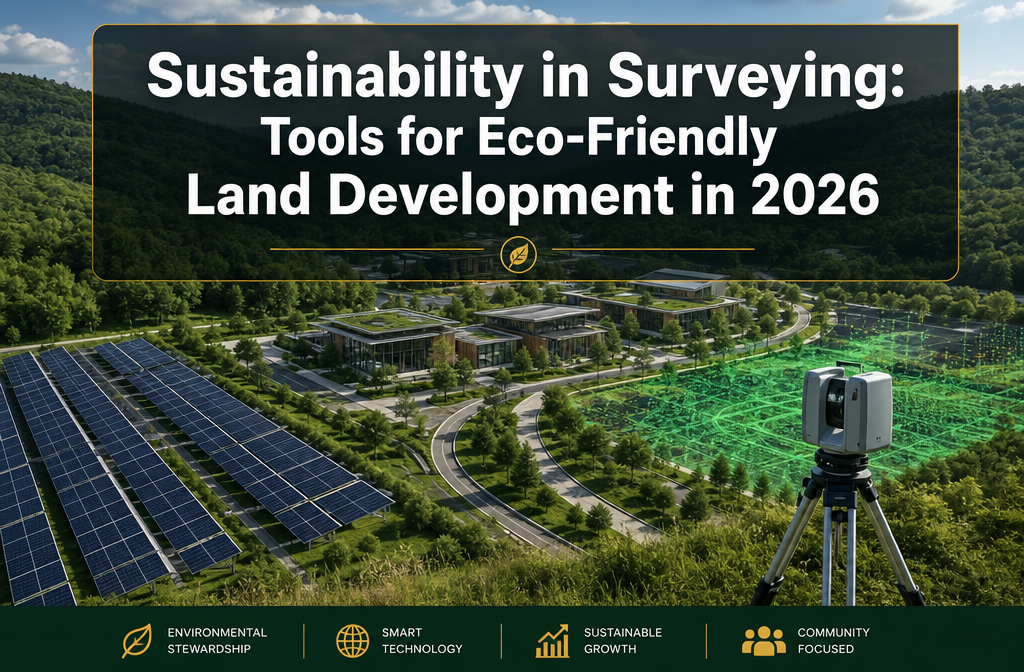
By 2026, 85% of surveying firms have integrated drone technology into their workflows — not just for speed, but to actively reduce carbon footprints across land development projects. That single statistic signals a profound shift in how the profession operates. Sustainability in Surveying: Tools for Eco-Friendly Land Development in 2026 is no longer a niche conversation; it is the central framework shaping how land is assessed, planned, and developed across the UK and beyond.
Stricter environmental regulations, growing client demand for green credentials, and rapid advances in sensor technology have converged to make eco-friendly surveying both a commercial necessity and a professional responsibility. Surveyors who understand these tools — and the ecological data they capture — are better positioned to support green building initiatives, satisfy planning authorities, and deliver measurable environmental value.
Key Takeaways 📋
- Sensor-driven ecological data is now central to sustainable land development, helping surveyors forecast environmental impacts before a single brick is laid.
- Drone technology, LiDAR, and remote sensing have dramatically reduced fieldwork emissions while improving data accuracy.
- Solar-powered equipment, electric vehicles, and biodegradable materials are replacing fossil-fuel-dependent tools across the industry.
- Digital reporting and GIS platforms like ArcGIS GreenPlanner are eliminating paper waste and optimising land-use decisions.
- Government incentives and certification programmes are accelerating the adoption of sustainable surveying practices in 2026.
Why Ecological Sensors Are Changing the Game in 2026
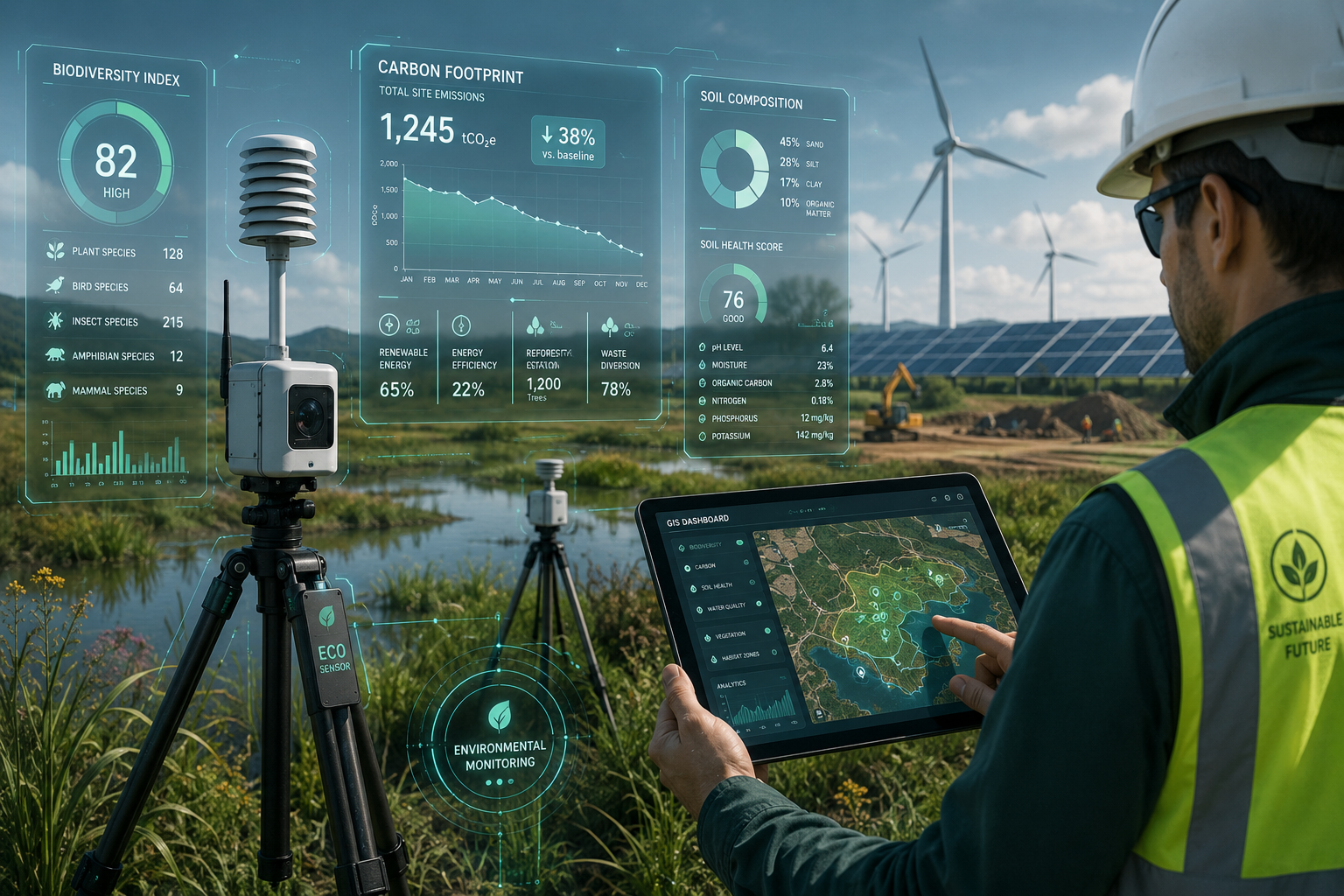
The most transformative development in eco-friendly land development is not a single tool — it is the integration of ecological sensors into the surveying process itself. These devices capture real-time data on soil composition, moisture levels, biodiversity indicators, air quality, and carbon sequestration potential. Rather than simply measuring land boundaries or structural conditions, surveyors can now generate a living environmental profile of a site.
💡 "The shift from measurement to ecological intelligence is the defining characteristic of sustainable surveying in 2026."
This matters enormously in the context of stricter planning regulations. UK planning authorities increasingly require Environmental Impact Assessments (EIAs) that go beyond basic land surveys. Ecological sensor data feeds directly into these assessments, providing planners and developers with evidence-based forecasts of how a project will affect local ecosystems, drainage patterns, and wildlife corridors.
How Sensors Support Green Building Initiatives
Modern ecological sensors work in tandem with Geographic Information Systems (GIS), allowing surveyors to layer environmental data onto spatial maps. This integration enables:
- Flood risk modelling based on real-time soil saturation data
- Carbon impact forecasting by measuring existing vegetation and biomass
- Habitat sensitivity mapping to identify protected species zones
- Noise and pollution dispersion modelling for urban development sites
According to the Remote Sensing Association (April 2026), 75% of land development projects now employ remote sensing technologies, significantly reducing the need for on-site visits and their associated emissions. For clients pursuing LEED certification — now a target for 60% of new land development projects according to the U.S. Green Building Council (May 2026) — this sensor-driven data is invaluable.
Understanding what a surveyor does and their professional responsibilities has expanded considerably as ecological competence becomes a core skill alongside traditional measurement expertise.
Sustainability in Surveying: Tools for Eco-Friendly Land Development in 2026 — The Core Toolkit
The toolkit available to sustainable surveyors in 2026 is broader and more capable than at any point in the profession's history. Below is a breakdown of the most impactful technologies currently in use.
🚁 Drone Technology
Drone adoption has reached 85% of surveying firms (ASCE, April 2026). Drones reduce the need for ground crews on large or ecologically sensitive sites, cutting vehicle emissions and minimising ground disturbance. They capture high-resolution aerial imagery, thermal data, and multispectral readings in a single flight — data that would previously require days of fieldwork.
Key environmental benefits:
- Reduced vehicle journeys to site
- Minimal soil compaction from foot traffic
- Faster data collection = lower cumulative emissions per project
📡 LiDAR Systems
Light Detection and Ranging (LiDAR) technology is now used in 70% of land development projects, delivering a 30% reduction in fieldwork time and associated emissions (NSPS, March 2026). LiDAR produces highly accurate 3D point clouds of terrain, enabling precise topographic modelling without repeated site visits.
For developments near sensitive ecosystems — such as ancient woodland or protected wetlands — LiDAR allows detailed planning without physical intrusion.
☀️ Solar-Powered Equipment
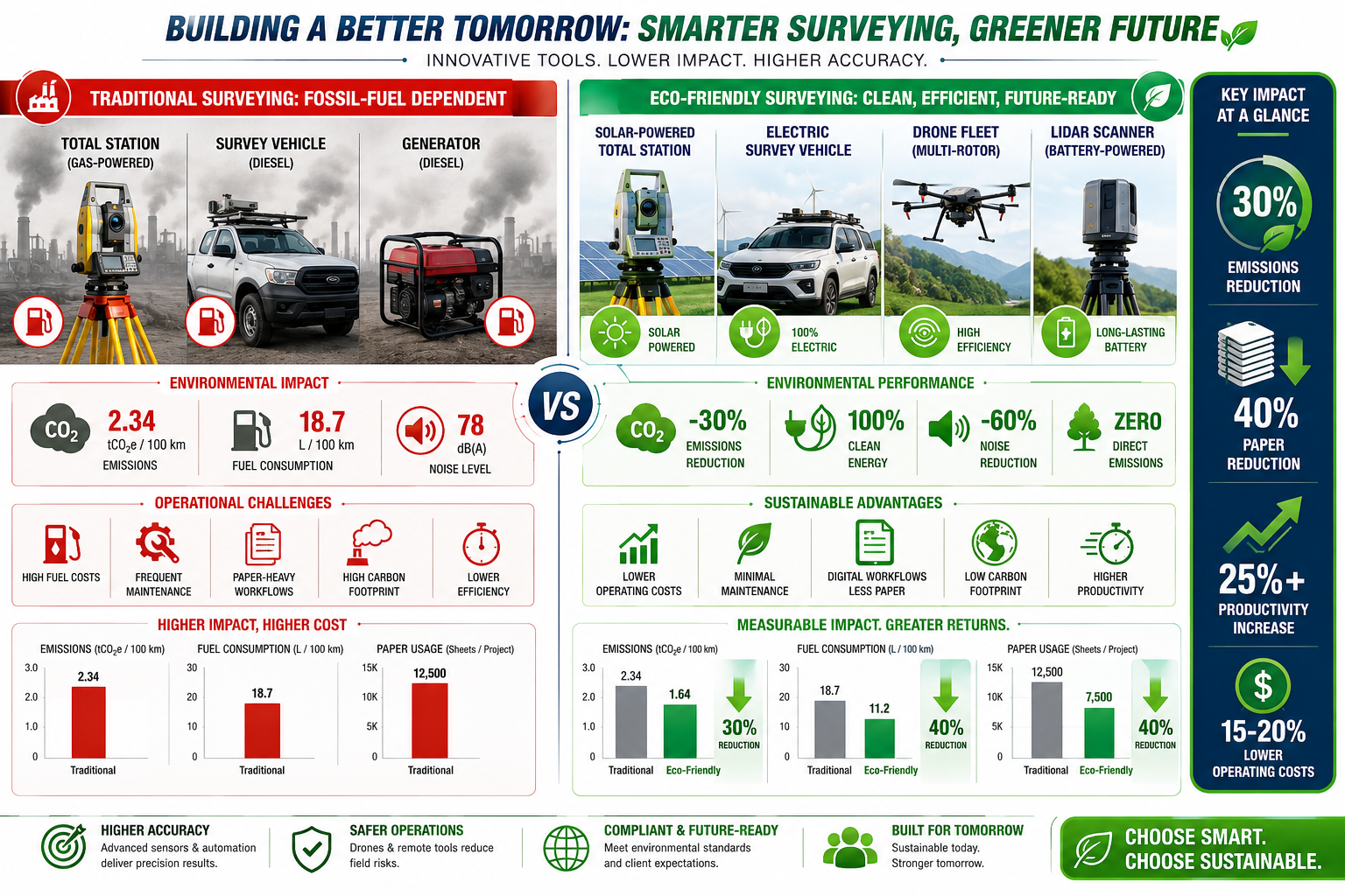
60% of surveying equipment manufacturers have introduced solar-powered total stations (U.S. Department of Energy, April 2026). These instruments eliminate the need for disposable batteries or petrol generators in the field, reducing both waste and fossil fuel dependency.
| Equipment Type | Traditional Power Source | Eco-Friendly Alternative |
|---|---|---|
| Total Stations | Lithium/alkaline batteries | Solar-charged units |
| Data Collectors | Mains charging | Solar/kinetic charging |
| Site Lighting | Diesel generators | Solar LED arrays |
| Survey Vehicles | Petrol/diesel | Electric vehicles (EVs) |
🚗 Electric Vehicles in Survey Fleets
The American Surveying Association (April 2026) reported that 65% of surveying firms have incorporated electric vehicles into their fleets, achieving a 25% reduction in transportation emissions. For UK-based firms operating across urban areas like London, EV adoption also supports compliance with Low Emission Zone requirements.
🌿 Biodegradable Marking Materials
Traditional surveying paint and stakes can persist in soil for years, disrupting local ecology. The Sustainable Surveying Coalition (March 2026) noted that biodegradable marking paints are now used in 80% of field operations. These materials break down naturally, leaving no toxic residue in sensitive environments.
📱 Digital Reporting and GIS Software
Paper elimination is one of the simplest yet most impactful sustainability wins. The Green Surveyors Association (April 2026) found that 90% of firms have transitioned to digital reporting, reducing paper consumption by 40%. Platforms like Esri's ArcGIS GreenPlanner (launched May 2026) go further, enabling surveyors to optimise land-use planning using embedded sustainability metrics — flagging carbon hotspots, green corridor requirements, and renewable energy potential directly within the mapping interface.
For those exploring the role of Geographic Information Systems in modern surveying, these platforms represent the most significant software advancement of the decade.
Regulations, Incentives, and Client Expectations Driving Change
Tightening Regulatory Frameworks
The regulatory environment in 2026 is unambiguous: eco-friendly land development is not optional. In the UK, the Environment Act places binding biodiversity net gain requirements on most new developments. Surveyors play a direct role in demonstrating compliance, using ecological sensor data and habitat assessments to evidence that a project delivers measurable environmental benefit.
Similarly, planning authorities now routinely require carbon impact statements as part of pre-application consultations. Surveyors equipped with the right tools can produce these statements efficiently and credibly.
Government Incentives
In the US, the EPA (March 2026) announced a grant programme offering up to $100,000 for surveying firms adopting eco-friendly technologies. While UK-specific equivalents vary by region, the direction of travel is consistent: governments are financially incentivising the transition to sustainable surveying practice.
The National Institute of Standards and Technology (NIST) also introduced a certification programme (May 2026) for surveyors focusing on sustainable land development techniques — a credential that is rapidly becoming a differentiator in competitive tender processes.
What Clients Are Demanding
Developers, housebuilders, and landowners are under their own ESG (Environmental, Social, and Governance) pressures. Institutional investors increasingly require green credentials across their property portfolios. This filters directly down to the surveyors they appoint.
Clients now routinely ask:
- ✅ Does this survey include an ecological impact assessment?
- ✅ What is the carbon footprint of the survey process itself?
- ✅ Can the data support a LEED or BREEAM application?
- ✅ Are biodegradable materials used on site?
Surveyors who cannot answer these questions confidently risk losing instructions to competitors who can.
Understanding why choosing RICS-accredited surveyors matters is increasingly tied to their sustainability credentials alongside technical competence.
Sustainability in Surveying: Tools for Eco-Friendly Land Development in 2026 — Practical Applications
Case Application: Pre-Development Ecological Screening
Before any planning application is submitted, a sustainable surveyor in 2026 might deploy the following workflow:
- Drone flyover to capture multispectral imagery identifying vegetation health and water bodies
- LiDAR scan to produce a precise terrain model and identify drainage patterns
- Soil sensors to measure contamination, carbon content, and compaction
- GIS analysis using ArcGIS GreenPlanner to overlay ecological constraints and identify optimal development zones
- Digital report submitted to the planning authority with full carbon impact data
This process replaces weeks of manual fieldwork with a faster, lower-emission, higher-accuracy alternative — and produces richer ecological data in the process.
Sustainable Materials in Instrument Construction
Beyond the tools themselves, 50% of new surveying instruments are now constructed using recycled or sustainable materials (International Federation of Surveyors, April 2026). This includes recycled aluminium tripods, bio-based polymer casings, and packaging made from post-consumer materials. The supply chain for surveying equipment is itself becoming greener.
Boundary Surveys and Habitat Protection
Even routine land boundary surveys now incorporate ecological considerations. Where a boundary runs through a hedgerow, watercourse, or protected habitat, surveyors use non-invasive techniques — including drone-based photogrammetry and remote sensing — to avoid disturbing protected species.
This is particularly relevant in the UK, where boundary disputes often involve land that has ecological or amenity value. A surveyor who can demonstrate habitat-sensitive practice is a stronger expert witness and a more credible professional adviser.
Building Surveys and Sustainability Assessments
The intersection of sustainability and property surveys extends beyond land development. Choosing the right level of building survey now often includes consideration of a property's environmental performance — insulation quality, damp risks, and energy efficiency indicators.
A specific defect survey can identify issues like inadequate insulation or failing damp-proof courses that directly affect a building's carbon performance. Addressing these defects is both a sustainability action and a financial protection for buyers.
Similarly, damp surveys are increasingly framed within an energy efficiency context — persistent damp increases heating demand and reduces a property's EPC rating, making early detection a sustainability priority as much as a structural one.
Barriers to Adoption and How to Overcome Them
Despite the momentum, not all surveying firms have made the transition at the same pace. Common barriers include:
| Barrier | Solution |
|---|---|
| High upfront equipment costs | Government grants, equipment leasing, phased adoption |
| Skills gaps in new technology | NIST certification, CPD programmes, manufacturer training |
| Client unawareness of green options | Proactive communication, sustainability reports as standard |
| Data management complexity | Cloud-based GIS platforms, standardised digital workflows |
| Resistance to change in established firms | Leadership buy-in, ESG reporting requirements as a driver |
The International Federation of Surveyors (FIG) has been instrumental in publishing guidance on sustainable practice, and RICS continues to update its competency frameworks to embed environmental literacy at every level of the profession.
Conclusion: Actionable Next Steps for Surveyors and Developers
Sustainability in Surveying: Tools for Eco-Friendly Land Development in 2026 is not a future aspiration — it is the present standard. The combination of ecological sensors, drone technology, LiDAR, solar-powered equipment, and GIS platforms has given the profession tools that are simultaneously more accurate, more efficient, and more environmentally responsible than anything available a decade ago.
For surveyors and developers looking to act now, here are the most impactful next steps:
- Audit your current toolkit — identify which equipment can be replaced with solar-powered or lower-emission alternatives.
- Invest in GIS training — platforms like ArcGIS GreenPlanner are becoming industry standard; competency is a competitive advantage.
- Pursue sustainability certification — NIST's new programme and RICS environmental competencies signal what clients and regulators will expect.
- Integrate ecological data into every survey brief — even where not yet required, proactively capturing environmental data adds value and future-proofs your reports.
- Switch to digital-first reporting — the 40% reduction in paper consumption is achievable immediately with existing software.
- Transition your vehicle fleet — EV adoption delivers both emission reductions and operational cost savings over time.
The surveyors who thrive in this environment will be those who see ecological intelligence not as an add-on, but as a core professional competency. The tools are available. The regulations are tightening. The clients are asking. The time to act is now.
Explore how a professional building survey can support sustainable property decisions and speak to a qualified RICS surveyor about integrating eco-friendly practices into your next land development project.