

{"cover":"Professional landscape format (1536×1024) hero image with bold text overlay 'Slope Assessment in Building Surveys' in crisp white sans-serif on a deep navy semi-transparent overlay panel, centered with 8% safe margins from every edge, two lines balanced in length, no character touching the edge. Background: dramatic daylight editorial photograph of a UK residential property built on a visibly sloping garden plot in south-east England, showing a terraced hillside, retaining walls, and a RICS-branded surveyor in a hi-vis vest taking measurements with a total station instrument on the gradient. Lush green grass, overcast British sky, warm stone house facade. Magazine-cover aesthetic, high contrast, professional editorial quality, teal and navy palette.","content":["Annotated documentary photography landscape format (1536×1024): a RICS chartered surveyor in professional attire crouching beside a brick retaining wall on a steeply sloping residential garden in south London, using a moisture meter against the wall base. Four callout labels with thin teal lines pointing to: 'Surface water flow direction', 'Low-level airbrick position', 'Retaining wall face', 'Drainage gully'. Overcast natural British daylight, realistic documentary style, navy and teal palette, editorial quality, clean white label boxes, no full sentences as labels.","Numbered step-by-step process flow diagram landscape format (1536×1024): five horizontal stages illustrating a UK building surveyor's slope assessment workflow on a sloping residential site. Stage 1 label: 'Topographic Survey', small icon of a total station instrument. Stage 2: 'Soil and Geology Check', icon of a trial pit cross-section. Stage 3: 'Drainage Assessment', icon of French drain cross-section. Stage 4: 'Foundation and Retaining Wall Inspection', icon of a stepped foundation diagram. Stage 5: 'BGS Data Review', icon of a geological map. Clean white background, teal-to-navy gradient connecting arrows, bold stage headings, short 2-4 word sub-labels beneath each icon, editorial infographic style, professional and modern.","Split-screen editorial comparison landscape format (1536×1024): left panel labelled 'Level Site' shows a flat suburban UK garden with a standard strip foundation diagram, uniform drainage arrows, and a green 'Low Risk' badge. Right panel labelled 'Sloping Site' shows a cross-section of a hillside UK property with stepped foundations, a retaining wall, French drain, surface water run-off arrows, and an amber 'Elevated Risk' badge. Thin dividing line down the centre, callout labels on each side: 'Foundation depth', 'Water ingress path', 'Retaining wall load', 'Drainage requirement'. Teal and navy palette, clean white background, bold panel headings, editorial infographic quality."]
Around one in five residential properties in the UK is built on ground that slopes by more than 1 in 10, yet slope-related risks remain among the most under-reported issues in standard homebuyer surveys. For buyers in London and the south-east, where hillside streets, terraced gardens, and cut-and-fill plots are common from Croydon to Harrow, understanding what a surveyor actually examines on a sloping site can be the difference between a sound purchase and a costly mistake.
Slope Assessment in Building Surveys: What UK Surveyors Look For on Sloping Sites is a specialist discipline that combines drainage analysis, foundation inspection, geotechnical data review, and retaining wall evaluation. This article explains each of those elements in plain terms, drawing on current UK practice and guidance, so that homeowners and buyers know exactly what to expect when a surveyor visits a property on uneven ground.
Key Takeaways
- Properties on sloping sites face significantly higher risks of water ingress, foundation movement, and retaining wall failure than those on flat ground.
- UK surveyors assess slope gradient, surface drainage, soil type, foundation design, and retaining wall condition as core elements of any slope evaluation.
- British Geological Survey (BGS) data and environmental search reports are now standard tools for identifying ground stability hazards on sloping plots.
- A Level 3 Building Survey (full structural survey) is almost always the appropriate choice for sloping sites, rather than a basic homebuyer report.
- Early commissioning of a topographic survey and, where needed, geotechnical investigation can prevent expensive surprises after purchase.
Why Sloping Sites Demand a Different Survey Approach
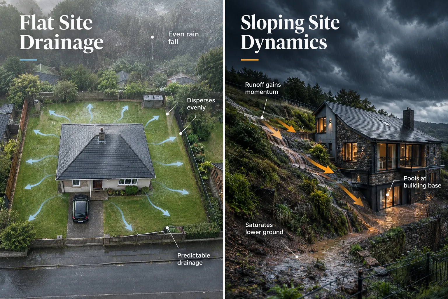
A flat site drains predictably. Rain falls, runs across the surface, and disperses. On a sloping site, water has direction and momentum. It travels downhill, pools against structures, saturates ground at the base of slopes, and, if drainage is inadequate, finds its way through walls, floors, and subfloor voids.
Any property on a sloping site is more susceptible to water-related problems than one on a flat site [1]. This is not a marginal difference. Surveyors working on sloping plots in south London boroughs such as Lewisham, Battersea, and Croydon regularly encounter properties where decades of inadequate slope drainage have caused progressive damp penetration, mortar decay, and even structural movement that was never flagged at the point of sale.
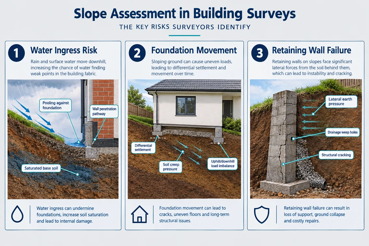
The core reason a different survey approach is needed comes down to three interacting factors:
- Water management: rainwater moves toward the building rather than away from it
- Ground pressure: soil on a slope exerts lateral as well as vertical loads on foundations and walls
- Geological variability: sloping ground often exposes different soil and rock strata at different depths, creating uneven bearing conditions
A building condition assessment on a sloping site must therefore go beyond the standard visual checks applied to a level plot. It requires the surveyor to think about the site as a dynamic system in which water, soil, and structure interact continuously.
The Role of Gradient
Not all slopes are equal. UK surveyors typically distinguish between:
| Gradient | Description | Risk Level |
|---|---|---|
| Less than 1:20 | Gently sloping | Low, standard drainage checks apply |
| 1:20 to 1:10 | Moderately sloping | Medium, drainage and foundation scrutiny required |
| 1:10 to 1:5 | Steeply sloping | High, retaining walls, cut/fill, geotechnical data needed |
| Steeper than 1:5 | Very steep | Very high, specialist geotechnical input likely essential |
RICS New Rules of Measurement (NRM2) include a specific classification for "sloping work >15°", reflecting the added complexity and cost of construction on steep slopes [2]. This classification matters in practice because it signals to surveyors and quantity surveyors that any site exceeding this threshold requires explicit measurement and pricing of slope-related work, from access scaffolding to retaining structures.
What Surveyors Examine: The Core Elements of Slope Assessment in Building Surveys
1. Surface Water Drainage and Run-Off Management
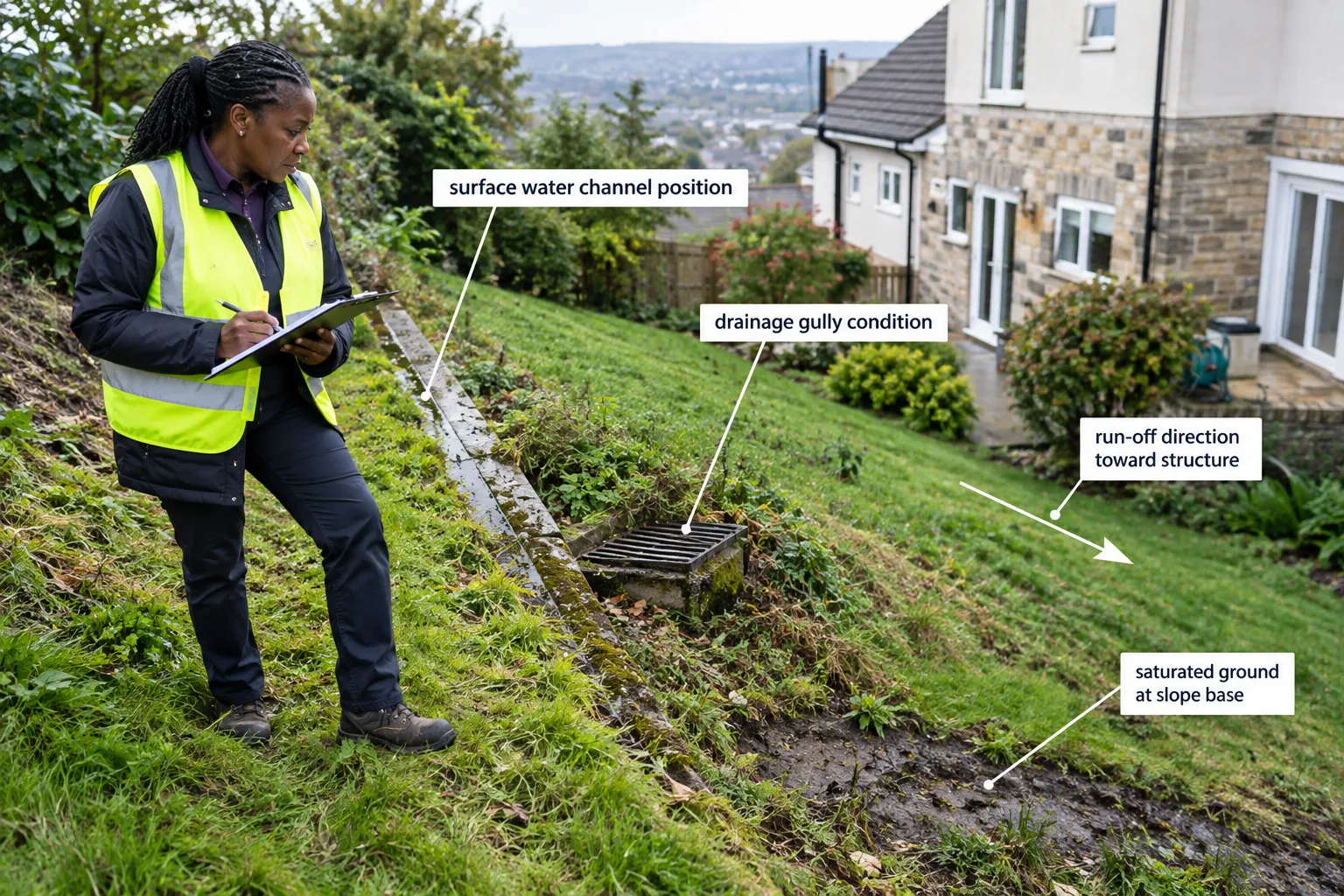
The first and most critical check on any sloping site is how surface water is managed. Surveyors look for evidence that water is being directed around the building rather than toward it [1].
Key items inspected include:
- The position and condition of drainage gullies and channels
- Whether airbricks are positioned at or below the effective ground level on the uphill side, a common problem where the slope has effectively raised the external ground level against the wall [1]
- The presence or absence of French drains, interceptor drains, or cut-off drains on the uphill boundary
- Evidence of water staining, moss growth, or soil saturation at the base of walls
- Whether downpipes discharge onto sloping ground rather than into drains
Where low-level airbricks are acting as entry points for surface water rather than ventilation openings, surveyors flag this as a significant defect. The fix, installing a French drain or run-off gully uphill of the airbrick, is relatively straightforward, but the consequences of ignoring it (wet subfloor void, timber decay, rising damp) are expensive [1].
"Surveyors are advised to check how surface water is managed, whether low-level airbricks are acting as gutters, and whether measures like French drains or run-off gullies are needed to divert water around rather than through the structure." [1]
For buyers concerned about damp-related defects on sloping sites, understanding the damp survey process and what a report contains is a useful next step alongside the building survey itself.
2. Foundation Assessment on Sloping Ground
Foundations on sloping sites are inherently more complex than those on flat ground. Surveyors look for signs that the original foundation design accounted for the slope, and evidence that it has performed adequately over time.
Stepped foundations are the standard approach on sloping sites. Rather than following the slope, the foundation is built in horizontal steps, each step no deeper than the thickness of the foundation and no higher than the height of the masonry above. Surveyors check whether this stepping is visible and whether it appears to have been executed correctly.
Signs of foundation problems on slopes include:
- Diagonal cracking at corners and window openings, running from low to high
- Differential settlement, where one part of the building has moved more than another
- Out-of-plumb walls, particularly on the downhill side
- Gaps between extensions and the main structure
Subsidence risk is elevated on sloping sites, particularly where shrink-swell clays are present. Ground movement and subsidence risk on sloping sites are increasingly assessed using combined physical inspection and national datasets from the British Geological Survey (BGS), which evaluates factors such as shrink-swell clay, compressible ground, landslide potential, and running sand [5][6].
Buyers who receive a survey report flagging foundation or subsidence concerns should understand their options. The guide to subsidence, signs, causes and when to worry provides a clear explanation of how these issues are assessed and what remediation typically involves.
3. Retaining Wall Condition and Stability
Retaining walls are among the most common, and most frequently overlooked, structural elements on sloping residential sites. They hold back soil, manage level changes between gardens, and prevent slope failure. They also fail quietly, over years, until the failure becomes dramatic.
Surveyors inspect retaining walls for:
- Bulging or leaning, forward movement of the wall face indicates that the wall is no longer in equilibrium with the soil pressure behind it
- Cracking, horizontal cracks in the middle third of a wall are particularly serious, as they indicate bending failure
- Drainage, retaining walls must have weep holes or drainage channels to relieve hydrostatic pressure from groundwater; blocked drainage is a leading cause of retaining wall failure
- Foundation adequacy, shallow or inadequate foundations on the wall itself
- Age and construction type, dry-stone walls, unreinforced brick walls, and old concrete walls all have different failure modes and life expectancies
A retaining wall failure on a residential site can cause significant property damage and poses a safety risk. Where walls are over approximately 1 metre in retained height, surveyors will typically recommend a structural engineer's assessment. The structural surveyors and engineers service provides specialist input when retaining wall concerns are identified.
4. Geotechnical Data and Ground Stability Screening
Modern slope assessment in building surveys goes beyond what the eye can see. Commercial and residential environmental search reports now explicitly highlight ground stability hazards and advise clients to seek RICS-accredited surveyors to assess slope risks on affected sites [8].
Surveyors and conveyancers routinely commission ground stability screening reports that check for:
- Natural ground subsidence risk
- Shrink-swell clay distribution
- Landslide susceptibility
- Cavities (natural and man-made)
- Non-coal and coal mining legacy
Where these searches flag concerns, the surveyor's role is to correlate the data with physical observations, does the cracking pattern match the predicted shrink-swell risk? Does the slope geometry align with a mapped landslide susceptibility zone? This integration of desk-based data with site observation is what distinguishes a thorough slope assessment from a superficial visual inspection.
Self-build and residential design guidance published in 2026 recommends commissioning trial pits or boreholes to approximately 3 metres depth to investigate soil conditions, water table level, and water flow under different scenarios on sloping ground [14]. While this level of investigation is typically reserved for new build or significant extension projects, surveyors may recommend it where existing buildings show signs of ground movement on steep or geologically complex sites.
Topographic Surveys, Planning Requirements, and Slope Data
What a Topographic Survey Adds to a Building Survey
A standard building survey does not include a measured topographic survey of the site. However, for sloping plots, particularly where development, extension, or drainage works are planned, commissioning a topographic survey alongside the building survey provides critical additional data.
Topographic survey providers capture sloping distances, gradients, and key high and low points over the whole site and a margin beyond its boundary, because accurate slope data are critical to design and drainage assessments [9][10]. Standard deliverables include:
- Ground levels and contours
- Slopes and significant high/low points
- Existing drainage features
- Retaining wall positions and heights
- Relationship of the building floor levels to external ground levels [10]
For planning applications involving sloping sites, current UK practice requires local planning authorities to receive accurate topographical surveys with contours, spot heights, and detailed level information showing how the development sits on the land [7]. Guidance updated in 2026 specifies that sloping sites require:
- Contours and spot heights
- Existing and proposed site sections showing level changes
- Finished floor levels for all buildings
- Coverage of the full site plus 20 metres beyond the boundary
- A contour interval of 0.5 metres for sloping or complex sites [7]
This level of detail directly informs how surveyors specify and interpret slope data when assessing building layout, retaining walls, or drainage on sloping ground.
Modern Survey Technology on Sloping Sites
The tools available to surveyors assessing sloping sites have advanced considerably. Robotic total stations measure horizontal and vertical angles as well as sloping distances, building precise three-dimensional models of a site's levels and layout [9]. Long-range scanners can monitor ground movement on slopes, quarry walls, and hillsides, providing high-precision measurements of slope deformation over time [3].
Draft RICS guidance on aerial surveys (6th edition, consulted in early 2026) recognises that drone and LiDAR surveys can capture accurate height and slope data on gently sloping ground, slopes of less than 10°, provided suitable ground control points are established [13]. As a result, surveyors assessing sloping sites increasingly integrate aerial data and dense point clouds into their analysis of gradients, cut-and-fill volumes, and potential instability.
Geotechnical engineers also rely on repeated monitoring surveys of slopes to determine whether surface soil movement and cracking indicate slope failure [4]. Where a building survey identifies active movement on a sloping site, this kind of ongoing monitoring may be recommended as part of the remediation strategy.
Choosing the Right Survey for a Sloping Site
Not all property surveys are equal when it comes to sloping sites. The choice of survey level has a direct bearing on how thoroughly slope-related risks are identified and reported.
Level 2 (Homebuyer Report) provides a condition rating for visible defects but does not include structural analysis, detailed drainage assessment, or geotechnical commentary. For a property on a steeply sloping site, this level of survey is unlikely to provide sufficient information.
Level 3 (Building Survey / Full Structural Survey) is the appropriate choice for sloping sites. It includes a more thorough inspection of the structure, drainage, and site conditions, with specific commentary on slope-related risks. The surveyor can also provide advice on further investigations, geotechnical reports, structural engineer assessments, drainage surveys, where the initial inspection raises concerns.
For a detailed comparison of these options, the guide on choosing between a homebuyers survey and a full structural survey sets out the key differences and when each is appropriate.
Where a survey report does identify significant slope-related defects, buyers should understand their options for renegotiation. The average price reduction after a survey and how to renegotiate provides practical guidance on using survey findings in purchase negotiations.
Red Flags That Should Prompt Immediate Specialist Advice
The following findings in a building survey of a sloping site should always prompt further specialist investigation before exchange of contracts:
- Active cracking in retaining walls, particularly horizontal cracks
- Evidence of recent slope movement, fresh soil displacement, tilting trees or fence posts, new cracking in paths
- Persistent damp on the uphill side of the building with no apparent drainage provision
- Differential settlement between different parts of the structure
- BGS or environmental search data flagging landslide susceptibility or high shrink-swell clay risk
- Any indication of historic mining or quarrying activity beneath or adjacent to the slope
Conclusion
Slope assessment in building surveys is not a niche specialism, it is a fundamental part of evaluating any UK property where the ground is not flat. For buyers and homeowners in London and the south-east, where sloping plots are common across boroughs from Ealing to Lewisham, understanding what a surveyor looks for on a sloping site is essential preparation for a sound purchase decision.
Actionable next steps:
- Commission a Level 3 Building Survey for any property on a moderately or steeply sloping site. Do not rely on a Level 2 Homebuyer Report where slope-related risks are present.
- Request a ground stability environmental search as part of the conveyancing process. Review the results with your surveyor before the survey takes place, so that flagged hazards can be specifically examined on site.
- Ask the surveyor explicitly about drainage on the uphill side of the building, the condition of any retaining walls, and whether the foundation design appears appropriate for the slope.
- Commission a topographic survey if you are planning any extension, drainage works, or landscaping on a sloping site. Accurate level data prevent costly design errors.
- Act on specialist referrals. If the building survey recommends a structural engineer or geotechnical investigation, commission those reports before exchange, not after.
A property on a sloping site can be an excellent purchase. The key is ensuring that the survey is thorough enough to reveal what the slope is doing to the building, and what it might do in the future.
References
[1] Dampness Sloping Sites – 1stassociated.co.uk
[2] Rics Nrm21stedition – edshare.gcu.ac.uk
[3] miningsurveys.co.uk – miningsurveys.co.uk
[4] Geotechnical Engineers – cheshiresurveys.co.uk
[5] Natural Subsidence Assessment – surveyall.co.uk
[6] Public – bgs.ac.uk
[7] Topo Survey For Planning Permission – icelabz.co.uk
[8] Sitecheck Assess V2.0 1774280005788 – landmark.co.uk
[9] Land Topographic Surveys – southwestsurveys.co.uk
[10] Topographical Surveys – reedersurveys.co.uk