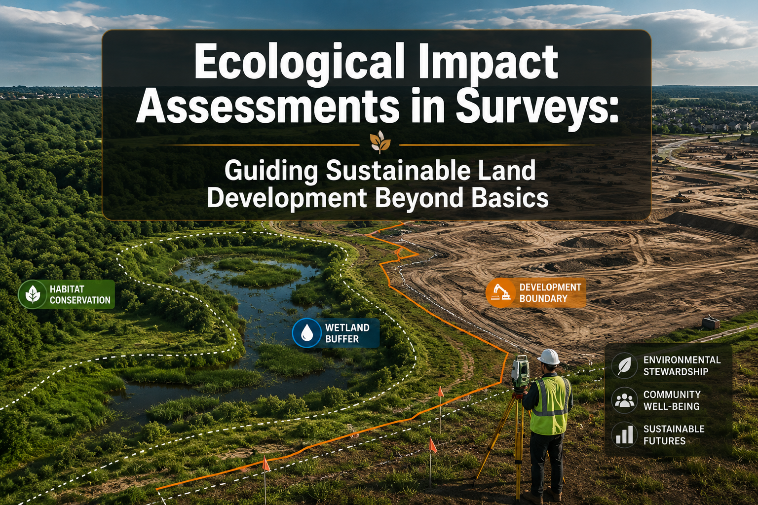
Forty percent of overall land take comes from projects that bypass full Environmental Impact Assessments — a figure that exposes a critical gap in how development is planned and approved [5]. For surveyors, developers, and planners working in 2026, understanding the full scope of Ecological Impact Assessments in Surveys: Guiding Sustainable Land Development Beyond Basics is no longer optional. It is the foundation of responsible, legally sound, and future-proof land development.
Ecological Impact Assessments (EcIAs) go far beyond a simple checklist of protected species. They integrate biodiversity data, soil health analysis, hydrological mapping, and long-term environmental forecasting into a structured process that shapes how land is used, developed, and managed. Surveyors who understand these tools are positioned not just as technical professionals, but as essential partners in eco-conscious projects.
Key Takeaways
- Ecological Impact Assessments are iterative, multi-stage processes that inform sustainable land development from the earliest planning stages.
- GIS technology is transforming how surveyors capture and analyse spatial ecological data, improving decision-making accuracy.
- Biodiversity, soil health, and long-term environmental forecasting are three core pillars that must be assessed beyond basic compliance requirements.
- Projects that skip or inadequately screen EcIAs account for a disproportionate share of harmful land take, underscoring the need for thorough preliminary appraisals.
- Surveyors who integrate ecological expertise into their practice add measurable value to development projects and reduce legal and reputational risk.
What Is an Ecological Impact Assessment and Why It Matters in Land Surveys
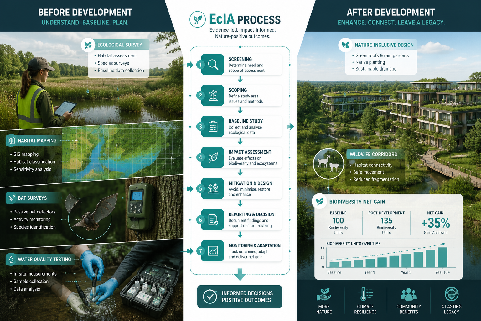
An Ecological Impact Assessment is a structured process used to identify, predict, and evaluate the effects of a proposed development on ecological receptors — including habitats, species, and ecosystem functions. The EcIA process is iterative, moving through scoping, detailed surveys, conservation value evaluation, and impact assessment to identify significant ecological effects and inform sustainable development practices [10].
In land surveying, EcIAs are not a standalone document produced at the end of a project. They begin at the same time as topographic and boundary surveys and continue to influence design, mitigation, and monitoring throughout a project's lifecycle. This integration is what separates basic compliance from genuinely sustainable development.
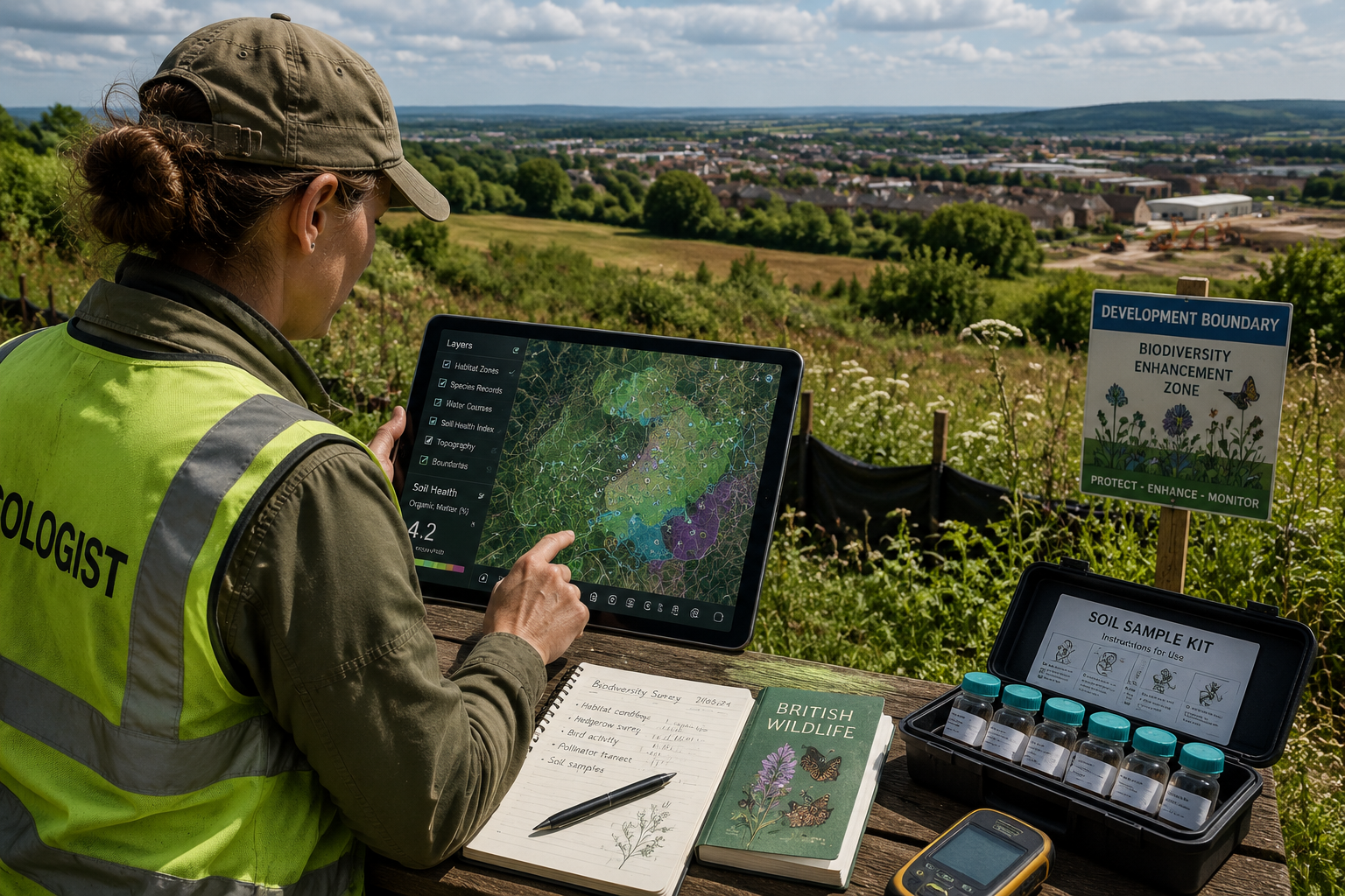
The Preliminary Ecological Appraisal: The First Critical Step
Before a full EcIA is commissioned, a Preliminary Ecological Appraisal (PEA) is conducted. This involves desk studies and habitat surveys to identify potential ecological constraints and determine whether further detailed surveys are needed [9]. A PEA typically includes:
- Review of existing biodiversity records and protected species data
- Phase 1 habitat survey of the site
- Assessment of potential for protected species (bats, great crested newts, dormice)
- Identification of designated sites within a defined search radius
- Recommendations for further targeted surveys
The PEA is the gateway document. It determines the scale and scope of what follows, and a poorly conducted PEA can result in significant delays, planning refusals, or costly redesigns later in the process. For surveyors working on land surveying projects in urban fringe or greenfield locations, commissioning a PEA early is one of the most cost-effective decisions a development team can make.
Core Tools for Capturing Biodiversity, Soil Health, and Environmental Forecasts
Ecological Impact Assessments in Surveys: Guiding Sustainable Land Development Beyond Basics requires familiarity with a growing toolkit of field and digital methods. The days of relying solely on walkover surveys and species lists are over. Modern EcIAs draw on remote sensing, acoustic monitoring, soil science, and predictive modelling to build a comprehensive picture of a site's ecological value and vulnerability.
Biodiversity Capture Tools
Accurate biodiversity data is the cornerstone of any EcIA. The following methods are now standard in high-quality assessments:
| Tool | Application | Output |
|---|---|---|
| Phase 1 and Phase 2 Habitat Surveys | Mapping vegetation communities | Habitat classification maps |
| Bat Acoustic Detectors | Identifying bat species and activity | Species-specific activity data |
| Camera Traps | Detecting mammals and ground-nesting birds | Presence/absence and behaviour data |
| eDNA Sampling | Detecting aquatic species (e.g. great crested newt) | Species presence confirmation |
| Breeding Bird Surveys | Quantifying bird populations | Territory maps and abundance data |
| Invertebrate Transects | Assessing pollinator and indicator species | Biodiversity index scores |
eDNA (environmental DNA) sampling deserves particular attention. By collecting water or soil samples and analysing the genetic material left behind by organisms, ecologists can confirm the presence of protected species without the need for intensive trapping or handling. This method is faster, less disruptive, and increasingly accepted by statutory consultees.
Soil Health Assessment
Soil is often the overlooked dimension of ecological surveys. Yet soil health directly determines habitat quality, carbon storage capacity, and the long-term viability of any ecological mitigation or enhancement measures proposed on a site.
Key soil health indicators assessed in EcIAs include:
- Soil organic matter content — a proxy for carbon storage and biological activity
- Compaction levels — affecting drainage, root penetration, and invertebrate communities
- pH and nutrient status — determining which plant communities can establish
- Contamination screening — identifying legacy pollutants that may affect ecological receptors
Integrating ecological information into land-use planning, including soil health data, is strongly supported by research advocating for interdisciplinary approaches and the development of environmental indicators to inform planning efforts [7]. Surveyors who include soil health data in their reporting provide planners and developers with a more complete picture of a site's constraints and opportunities.
GIS and Remote Sensing for Spatial Analysis
Geographic Information Systems (GIS) have become indispensable in modern EcIAs. A recent study highlights the growing use of GIS in ecological impact assessments, emphasising its role in enhancing spatial analysis and decision-making processes, while also identifying practical challenges for more effective integration [1].
GIS enables surveyors and ecologists to:
- Layer multiple datasets (habitats, species records, soil types, hydrology) on a single map
- Calculate distances from designated sites and ecological corridors
- Model the spatial extent of predicted impacts
- Visualise cumulative effects across a landscape
- Produce defensible, reproducible outputs for planning submissions
Remote sensing tools — including drone-mounted multispectral cameras and LiDAR — add a further dimension by capturing canopy structure, vegetation density, and land surface characteristics that ground surveys alone cannot provide.
Long-Term Environmental Forecasting
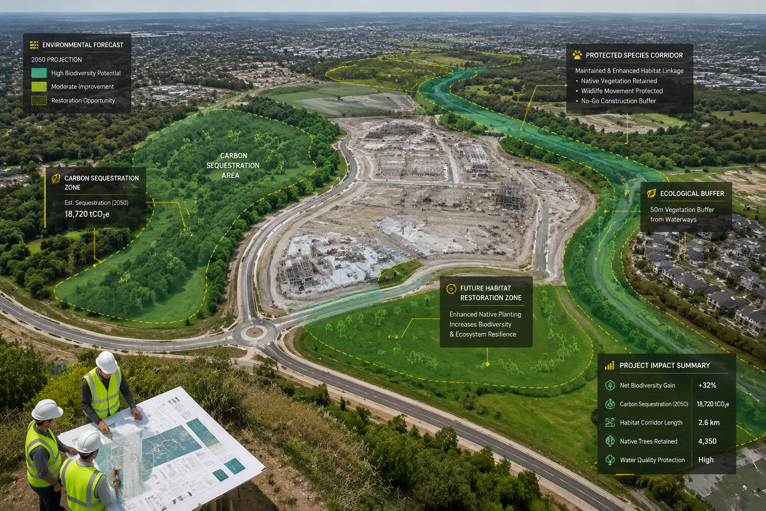
One of the most significant advances in EcIA practice is the integration of long-term environmental forecasting. Rather than assessing a site's ecological value at a single point in time, forecasting models project how habitats and species populations are likely to change under different development and climate scenarios.
Research on windfarm projects in Scotland's peatlands illustrates the consequences of failing to consider ecosystem-level impacts over time, advocating for more comprehensive assessments that account for cumulative and long-term effects [3]. This ecosystem approach — looking at the full functional system rather than individual species — is now considered best practice in complex or sensitive sites.
Forecasting tools used in advanced EcIAs include:
- Biodiversity Net Gain (BNG) calculators — quantifying habitat losses and gains over a 30-year horizon
- Climate envelope modelling — predicting species range shifts under future climate scenarios
- Hydrological impact models — assessing changes to water table and flood risk
- Carbon accounting frameworks — calculating net carbon flux from land use change
Significance Determination, BREEAM Standards, and the Surveyor's Role
Ecological Impact Assessments in Surveys: Guiding Sustainable Land Development Beyond Basics also requires understanding how ecological impacts are judged and communicated to decision-makers. This is where the concept of significance determination becomes critical.
A review of current EcIA practices identifies the need for standardised methodologies in determining significance, calling for improvements to ensure consistent and effective assessments of ecological impacts [4]. Without a consistent framework, two assessors can evaluate the same impact and reach very different conclusions — creating uncertainty for planners, developers, and statutory consultees alike.
How Significance Is Determined
Significance in EcIA is typically assessed by combining two factors:
- The value or sensitivity of the ecological receptor (e.g., a nationally designated habitat versus a degraded grassland)
- The magnitude of the predicted impact (e.g., permanent loss versus temporary disturbance)
These two factors are combined — often using a matrix — to produce an overall significance rating: negligible, minor, moderate, major, or major adverse. Only impacts rated as moderate or above typically require detailed mitigation measures or trigger statutory consultation requirements.
BREEAM Land Use and Ecology Assessments
For commercial and large-scale residential developments seeking BREEAM certification, ecological assessment requirements go beyond standard planning obligations. BREEAM assessments now require evaluations by Suitably Qualified Ecologists (SQEs) to identify habitat enhancements and ensure compliance with environmental legislation, with ecological considerations integrated from the project's inception [2].
This means that surveyors working on BREEAM-rated projects must coordinate with ecological consultants from the earliest design stages — not as an afterthought. Credits are awarded for:
- Protecting and enhancing existing ecological features
- Increasing the ecological value of the site through planting and habitat creation
- Achieving Biodiversity Net Gain above the statutory 10% minimum
- Long-term management plans supported by ecological monitoring
Surveyors as Key Players in Eco-Conscious Projects
The role of the surveyor in EcIA-informed development extends well beyond data collection. Surveyors bring spatial accuracy, legal awareness, and site knowledge that ecologists working in isolation may lack. This is particularly relevant when assessing boundary conditions, drainage patterns, and the physical constraints that shape what mitigation is actually deliverable.
For those considering a homebuyers report or building survey on a property with significant garden or land areas, understanding the ecological context of a site can also inform the survey's findings — particularly where protected species, trees subject to Tree Preservation Orders, or designated habitats are present.
Similarly, choosing the right property assessment for a site that may have ecological sensitivities requires a surveyor who understands the interface between physical condition and environmental constraint.
Practical Application: From Site Assessment to Sustainable Outcomes
Understanding the theory of EcIAs is one thing. Applying them effectively across different site types and development contexts is another. The following principles guide best practice application in 2026.
Screening and Scoping: Getting It Right from the Start
Effective project screening is the first line of defence against inadequate ecological assessment. Empirical evidence shows that projects bypassing full EIAs account for 40% of overall land take, highlighting the need for improved screening procedures to accurately quantify land use impacts [5]. A robust screening process asks:
- Does the site or its surroundings contain designated habitats or protected species?
- Is the development of a type and scale likely to cause significant ecological effects?
- Are there cumulative impacts from nearby developments that must be considered?
A comprehensive review of land use impact assessment methods identifies the predominance of agricultural land use studies and the growing interest in incentive-driven methods such as Life Cycle Assessment (LCA), which can complement traditional EcIA approaches [6].
Mitigation Hierarchy
All EcIAs follow the mitigation hierarchy, applied in strict order:
- Avoid — redesign the project to eliminate the impact entirely
- Mitigate — reduce the magnitude or duration of unavoidable impacts
- Compensate — offset residual impacts through habitat creation or enhancement elsewhere
Only when all three steps have been genuinely applied can a development claim to have minimised its ecological footprint. Ecological assessment reports used in development applications evaluate site-specific ecological values and recommend mitigation measures to minimise environmental impacts [8], providing the evidential basis for planning conditions and legal agreements.
Monitoring and Adaptive Management
A completed EcIA is not the end of the process. Effective ecological management requires post-development monitoring to verify that predicted impacts have materialised as expected and that mitigation measures are functioning as intended. Monitoring programmes typically run for five to ten years post-construction, with results reported to the local planning authority.
For surveyors involved in construction surveying projects, understanding the monitoring requirements attached to planning conditions is essential. Failure to comply with ecological monitoring conditions can result in enforcement action and reputational damage for the entire development team.
Surveyors should also be aware of the intersection between ecological conditions and legal requirements attached to planning permissions, particularly where protected species licences or habitat management agreements are in place.
Conclusion: Actionable Next Steps for Surveyors and Developers
Ecological Impact Assessments in Surveys: Guiding Sustainable Land Development Beyond Basics is not a niche specialism reserved for large infrastructure projects. In 2026, it is a core competency for any professional involved in land development, from initial site appraisal through to post-construction monitoring.
The following actionable steps will help surveyors and developers integrate ecological assessment effectively:
- Commission a Preliminary Ecological Appraisal early — before any design work is fixed, to avoid costly redesigns later.
- Invest in GIS capability — either in-house or through specialist consultants — to produce spatially robust, defensible assessments.
- Adopt the ecosystem approach — assess cumulative and long-term impacts, not just species-level effects at a single point in time.
- Engage Suitably Qualified Ecologists for BREEAM and Biodiversity Net Gain calculations, ensuring outputs meet statutory and certification requirements.
- Build monitoring into project budgets — ecological monitoring is a planning condition, not an optional extra.
- Coordinate with surveyors from day one — the spatial accuracy and legal awareness that surveyors bring is essential to translating ecological findings into deliverable mitigation.
For those working on what to do before an RICS home survey or managing a site with complex environmental conditions, early engagement with both surveyors and ecologists is the single most effective way to protect the value of a development and ensure it meets the growing expectations of planners, investors, and communities in 2026.
References
[1] mdpi – https://www.mdpi.com/2071-1050/17/22/10358?utm_source=openai
[2] Breeam Land Use Ecology Assessments – https://e3ecology.co.uk/e3-service/breeam-land-use-ecology-assessments/?utm_source=openai
[3] S0195925517303815 – https://www.sciencedirect.com/science/article/abs/pii/S0195925517303815?utm_source=openai
[4] S0195925512000364 – https://www.sciencedirect.com/science/article/abs/pii/S0195925512000364?utm_source=openai
[5] S0195925517302251 – https://www.sciencedirect.com/science/article/pii/S0195925517302251?utm_source=openai
[6] S0195925515300214 – https://www.sciencedirect.com/science/article/abs/pii/S0195925515300214?utm_source=openai
[7] research.fs.usda.gov – https://research.fs.usda.gov/treesearch/24495?utm_source=openai
[8] Ecological Assessment Reports – https://www.queenslandecologists.com.au/ecological-assessment-reports/?utm_source=openai
[9] Preliminary Ecological Appraisal – https://www.thomsonec.com/teh/chapter-11-ecological-studies-and-surveys/preliminary-ecological-appraisal/?utm_source=openai
[10] Chapter 12 Ecological Impact Assessment – https://www.thomsonec.com/teh/chapter-12-ecological-impact-assessment/?utm_source=openai