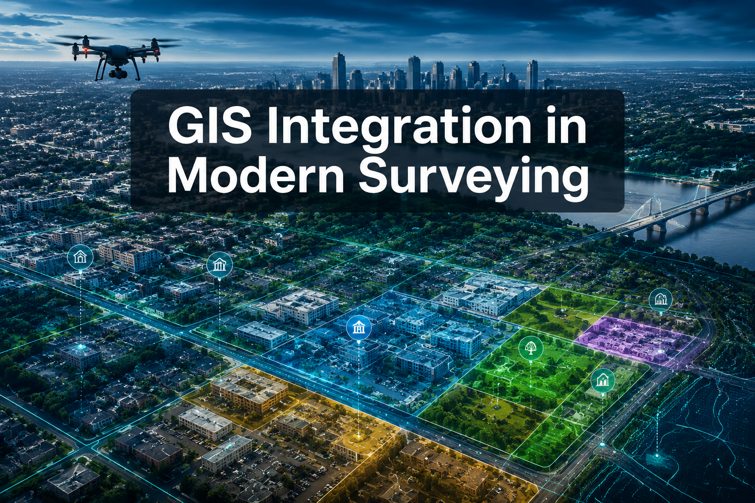
Surveying projects that once took months to complete are now finishing in half the time — not because surveyors are working faster, but because Geographic Information Systems are fundamentally changing how spatial data is collected, stored, and acted upon. GIS integration in modern surveying: better data management and enhanced decision-making is no longer a forward-looking ambition; it is the operational standard that separates competitive firms from those falling behind in 2026.
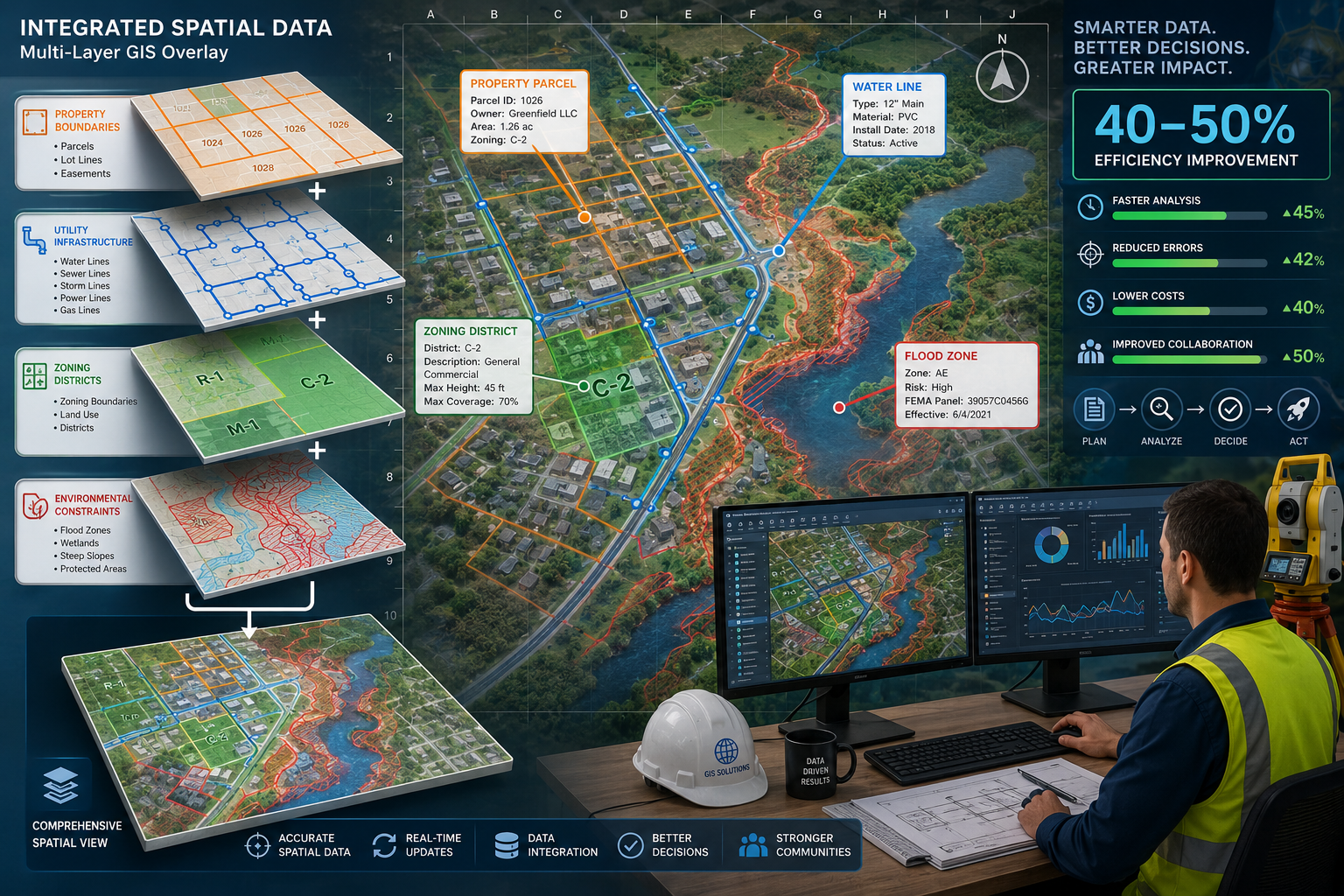
At its core, GIS centralizes vast geospatial datasets into a single, queryable environment. Surveyors can overlay property boundaries, utility corridors, zoning designations, and environmental constraints simultaneously, revealing spatial relationships that paper maps and siloed spreadsheets could never expose. The result is faster analysis, sharper visuals, and decisions grounded in evidence rather than assumption.
Key Takeaways
- GIS integration reduces surveying project timelines by 40-50% by consolidating multiple data sources into visual, interactive layers.
- Overlaying spatial data layers — boundaries, utilities, zoning, and environmental data — exposes critical relationships that traditional methods miss.
- Cloud-based GIS platforms enable real-time collaboration among surveyors, planners, and stakeholders across different locations.
- Advanced tools including drone-based LiDAR, GNSS/RTK systems, and IoT sensors feed high-accuracy data directly into GIS environments.
- Successful GIS adoption requires deliberate investment in hardware, software, staff training, and alignment with evolving geospatial standards.
How GIS Centralizes Geospatial Data for Modern Surveyors
Traditional surveying generated data in fragments: field notes here, CAD drawings there, boundary records filed in separate systems. GIS changes that architecture entirely. Rather than managing disconnected files, surveyors now work within a unified platform where every dataset — from topographic mapping records to utility easements — occupies a distinct, queryable layer.
The Layer-Based Approach to Data Organization
The power of GIS lies in its layer-based structure. Each type of spatial information is stored independently but can be displayed and analyzed together. A surveyor working on a development site might stack the following layers simultaneously:
| Data Layer | Information Provided |
|---|---|
| Property boundaries | Legal ownership limits and encroachments |
| Zoning districts | Permitted land uses and density restrictions |
| Utility networks | Underground pipe and cable locations |
| Environmental constraints | Flood zones, protected habitats, soil types |
| Topographic contours | Elevation changes and drainage patterns |
When these layers are combined, patterns emerge that no single dataset could reveal on its own. A proposed building footprint might appear compliant in isolation, but overlaying it with a flood zone layer and a utility easement simultaneously could expose a conflict that would have cost thousands to resolve later in the project lifecycle [1].
This approach directly supports better data management and enhanced decision-making by giving every stakeholder — surveyor, planner, engineer, and client — access to the same spatial truth at the same time.
Pattern Identification Across Complex Datasets
One of the most valuable capabilities GIS brings to building surveyor services and land assessment work is pattern identification. When spatial data accumulates over time — across multiple projects, sites, and years — GIS platforms allow analysts to query that data for recurring conditions.
For example, a firm conducting boundary surveys across a borough might use GIS to identify which street types or plot configurations most frequently generate boundary disputes. That intelligence feeds back into how future surveys are scoped and priced, reducing risk before fieldwork even begins.
GIS does not just store data — it transforms data into intelligence that surveyors can act on.
Federal agencies are reinforcing this shift. The National Spatial Reference System (NSRS) updates in 2026 require surveying firms to modernize their workflows and datasets to align with new geospatial standards, making GIS adoption not just advantageous but increasingly mandatory for compliance [1].
Advanced Technologies Powering GIS Integration in Modern Surveying

The quality of GIS analysis is only as good as the data feeding into it. Modern surveying has seen a dramatic leap in data collection precision, driven by tools that deliver centimeter-level accuracy across large areas in a fraction of the time traditional methods required [2].
GNSS, LiDAR, and Mobile Mapping Systems
Three technologies are reshaping how raw spatial data enters GIS platforms:
GNSS/RTK Positioning Systems — Global Navigation Satellite System receivers combined with Real-Time Kinematic corrections provide sub-centimeter horizontal accuracy in the field. Survey-grade GNSS data feeds directly into GIS databases, eliminating manual transcription errors and accelerating data processing.
Drone-Based LiDAR — Light Detection and Ranging sensors mounted on unmanned aerial vehicles generate dense three-dimensional point clouds over large areas. Urban planners and engineers are integrating this 3D data — alongside CAD and BIM files — within GIS platforms to produce detailed spatial representations of existing and proposed environments [4]. A site that once required weeks of ground-based measurement can now be captured in hours.
Mobile Mapping Systems — Vehicle-mounted sensor arrays combine cameras, LiDAR, and GNSS receivers to capture street-level spatial data at scale. These systems are particularly valuable for infrastructure corridor surveys and right-of-way assessments, where GIS delivers new capabilities to streamline processes and eliminate duplicated effort [5].
Cloud-Based GIS and Real-Time Collaboration
The shift from desktop GIS to cloud-based platforms has changed who can access survey data and when. Cloud environments allow multiple stakeholders — surveyors in the field, engineers at their desks, clients in another city — to view and interact with the same datasets simultaneously [2].
This real-time collaboration model offers several concrete advantages:
- Instant data updates: Field measurements uploaded from a mobile device appear in the shared GIS environment within minutes, not days.
- Interactive map sharing: Clients can explore spatial data through browser-based interfaces without needing specialist software.
- Version control: Changes to datasets are logged automatically, creating an audit trail that supports dispute resolution and regulatory compliance.
- Reduced duplication: When all parties work from a single source of truth, the risk of conflicting datasets causing project delays drops significantly.
IoT Integration and Real-Time Data Feeds
Modern GIS systems now support the ingestion of high-velocity observation data from Internet of Things platforms and sensor networks [4]. For surveying applications, this means ground movement sensors, water level monitors, and structural tilt meters can feed live readings directly into a GIS dashboard. Decision-makers receive immediate alerts when conditions change, enabling responses that protect both assets and people.
This capability is especially relevant for specific defect surveys and damp investigations, where environmental conditions — groundwater levels, seasonal moisture variation — directly influence findings and recommendations.
Enhanced Decision-Making Through GIS Visualization and Enterprise Integration

Collecting and storing geospatial data is only part of the value GIS delivers. The greater return comes from transforming that data into compelling visuals and connecting it to the broader systems organizations use to manage their work.
Creating Visuals That Support Planning and Development Decisions
GIS integration in modern surveying: better data management and enhanced decision-making hinges on the ability to communicate complex spatial information clearly. Raw coordinate data means little to a planning committee or a property developer. A color-coded zoning map overlaid on a satellite image, annotated with proposed development boundaries and environmental constraints, tells a story that drives decisions.
Effective GIS visualization includes:
- Heat maps showing density of a specific condition (e.g., subsidence risk) across a geographic area
- 3D terrain models that illustrate how proposed structures relate to surrounding topography
- Time-series animations demonstrating how land use or environmental conditions have changed over years
- Scenario comparison views that display multiple development options side by side
These visuals are not decorative. They reduce the cognitive load on decision-makers, surface trade-offs clearly, and accelerate approvals. Projects that once stalled in committee because stakeholders could not agree on what the data showed now move forward because the spatial evidence is unambiguous.
Research confirms that GIS integration has reduced project timelines by 40-50% by consolidating multiple data sources into visual layers that enable faster analysis and decision-making [1]. For firms managing complex, multi-site portfolios, that efficiency compounds into significant competitive advantage.
GIS as the Backbone of Modern Planning Systems
Modern planning increasingly treats GIS as a backbone system — the connective tissue linking data, people, and decisions across municipal departments and private stakeholders [1]. Rather than each department maintaining its own maps and records, a shared GIS environment becomes the authoritative source for all spatial decisions.
GIS platforms are also integrating with enterprise business systems including customer relationship management (CRM) and enterprise resource planning (ERP) platforms [3]. This interoperability means that a surveying firm's project management system, billing platform, and field data collection tools can all exchange spatial information with the central GIS environment. The practical benefit is that project status, resource allocation, and spatial analysis all live in connected systems rather than separate silos.
For professional surveyor services operating across multiple locations, this integration reduces administrative overhead and ensures that the spatial context of every project is visible to everyone who needs it.
GIS in Right-of-Way and Infrastructure Management
Right-of-way management is one of the most data-intensive areas of infrastructure development. Coordinating land acquisition, utility relocation, environmental permitting, and stakeholder engagement across a linear corridor involves hundreds of spatial records that must remain accurate and current throughout a project's life.
GIS delivers specific capabilities that streamline right-of-way processes: eliminating duplicated data entry, providing a spatial framework for tracking acquisition status parcel by parcel, and generating the visual reports that regulatory agencies require [5]. When a highway authority can see every parcel's acquisition status on a single map — color-coded by stage — the coordination effort that once consumed weeks of staff time becomes a daily management task.
Overcoming Barriers to GIS Adoption
Despite its clear benefits, GIS integration is not without challenges. Successful implementation requires deliberate investment across four areas [1]:
- Hardware — Field-grade devices, servers or cloud subscriptions, and data storage infrastructure
- Software — GIS platform licenses, data conversion tools, and integration middleware
- Training — Staff must develop proficiency not just in GIS software but in spatial data management principles
- Qualified personnel — Firms need staff who can bridge the gap between traditional surveying expertise and GIS analysis
The investment is real, but so is the return. Firms that have fully integrated GIS report not only faster project delivery but also improved client satisfaction, fewer post-survey disputes, and stronger positioning for public-sector contracts that increasingly require GIS-compatible deliverables.
For those exploring geographic information systems in GIS as part of a broader service offering, starting with a pilot project — a single site type or project category — allows teams to build competency before scaling adoption across the firm.
Conclusion
GIS integration in modern surveying: better data management and enhanced decision-making represents one of the most significant shifts the profession has seen in decades. By centralizing geospatial data into layered, queryable environments, GIS enables surveyors to identify patterns, produce compelling visuals, and support planning decisions with a clarity that traditional methods cannot match.
The technologies feeding these systems — GNSS/RTK, drone LiDAR, mobile mapping, and IoT sensors — continue to improve in accuracy and accessibility. Cloud platforms are making real-time collaboration standard rather than exceptional. Enterprise integration is connecting spatial intelligence to the business systems that drive organizational decisions.
Actionable next steps for surveying professionals in 2026:
- Audit current data workflows to identify where GIS integration would eliminate the most duplication or delay
- Evaluate cloud-based GIS platforms against project volume and collaboration requirements before committing to a specific solution
- Invest in staff training alongside software — the human capability to interpret and communicate spatial data is as important as the tool itself
- Align datasets and workflows with the updated National Spatial Reference System standards to maintain regulatory compliance
- Start with a defined pilot project to build internal confidence and demonstrate ROI before firm-wide rollout
Firms that treat GIS not as a software purchase but as a strategic capability will be best positioned to win complex projects, serve clients more effectively, and contribute to the evidence-based planning decisions that communities depend on.
For surveyors looking to understand how modern survey research principles connect to technology-driven practice, or those considering how building surveys can be enhanced through better spatial data management, the path forward runs directly through GIS integration.
References
[1] GIS Integration For Surveyors Overlaying Data Layers To Optimize Land Use Planning And Development Decisions – https://www.canterburysurveyors.com/blog/gis-integration-for-surveyors-overlaying-data-layers-to-optimize-land-use-planning-and-development-decisions/
[2] GIS Integration In Land Surveying Enhancing Data Visualization And Decision Making – https://kingstonsurveyors.com/gis-integration-in-land-surveying-enhancing-data-visualization-and-decision-making/
[3] Integration GIS Government – https://www.icf.com/insights/analytics/integration-gis-government
[4] Data Management – https://www.esri.com/en-us/capabilities/data-management
[5] Right Of Way And GIS – https://www.esri.com/en-us/industries/blog/articles/right-of-way-and-gis
[6] GIS In Geospatial Intelligence – https://en.wikipedia.org/wiki/GIS_in_geospatial_intelligence