A 2022 PwC analysis found that fewer than half of UK construction and property firms had successfully integrated drone data into their existing workflows, despite years of industry enthusiasm for the technology [6]. That gap between promise and practice is precisely where clients lose money — paying for technology that looks impressive but delivers little actionable insight.
This article cuts through the marketing noise around using drones, laser scanning and AR in UK building surveys. It examines where these tools genuinely improve outcomes for clients — better defect detection, more defensible evidence, faster data collection — and where they add cost without proportionate benefit.
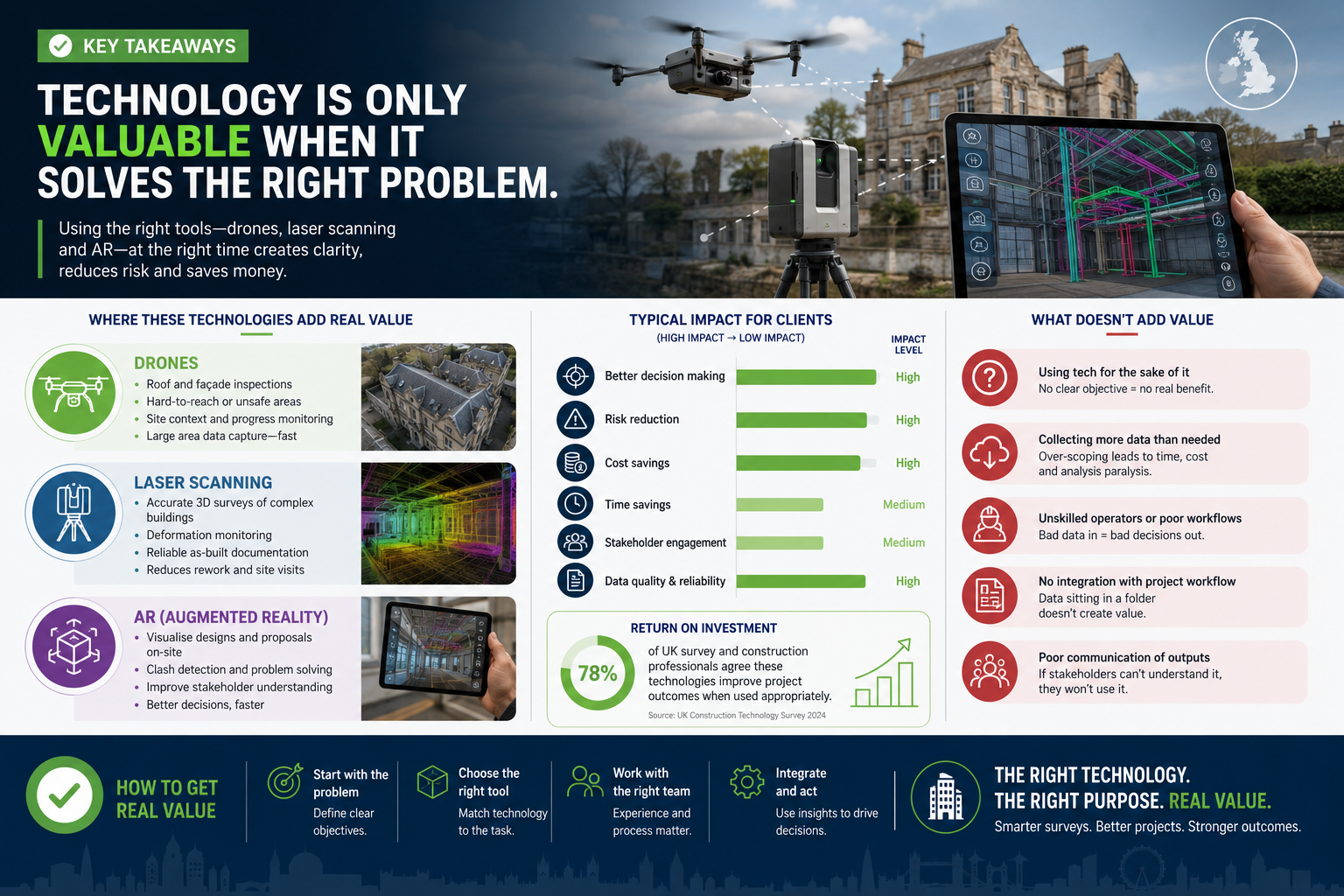
Key Takeaways
- Drones deliver clear value for roof, chimney and facade inspections on tall or inaccessible buildings, but add limited benefit on standard two-storey residential properties.
- Terrestrial laser scanning produces measurably more accurate spatial data than traditional measured surveys, making it essential for complex heritage, commercial and litigation contexts.
- Augmented reality in building surveys remains largely experimental in 2026; its practical value for most UK residential clients is still limited.
- Regulatory compliance under CAA rules and RICS standards is non-negotiable when deploying drones commercially.
- The best surveyors use technology selectively — matching the tool to the specific problem rather than applying it across every instruction.
Where Drones Genuinely Add Value in UK Building Surveys
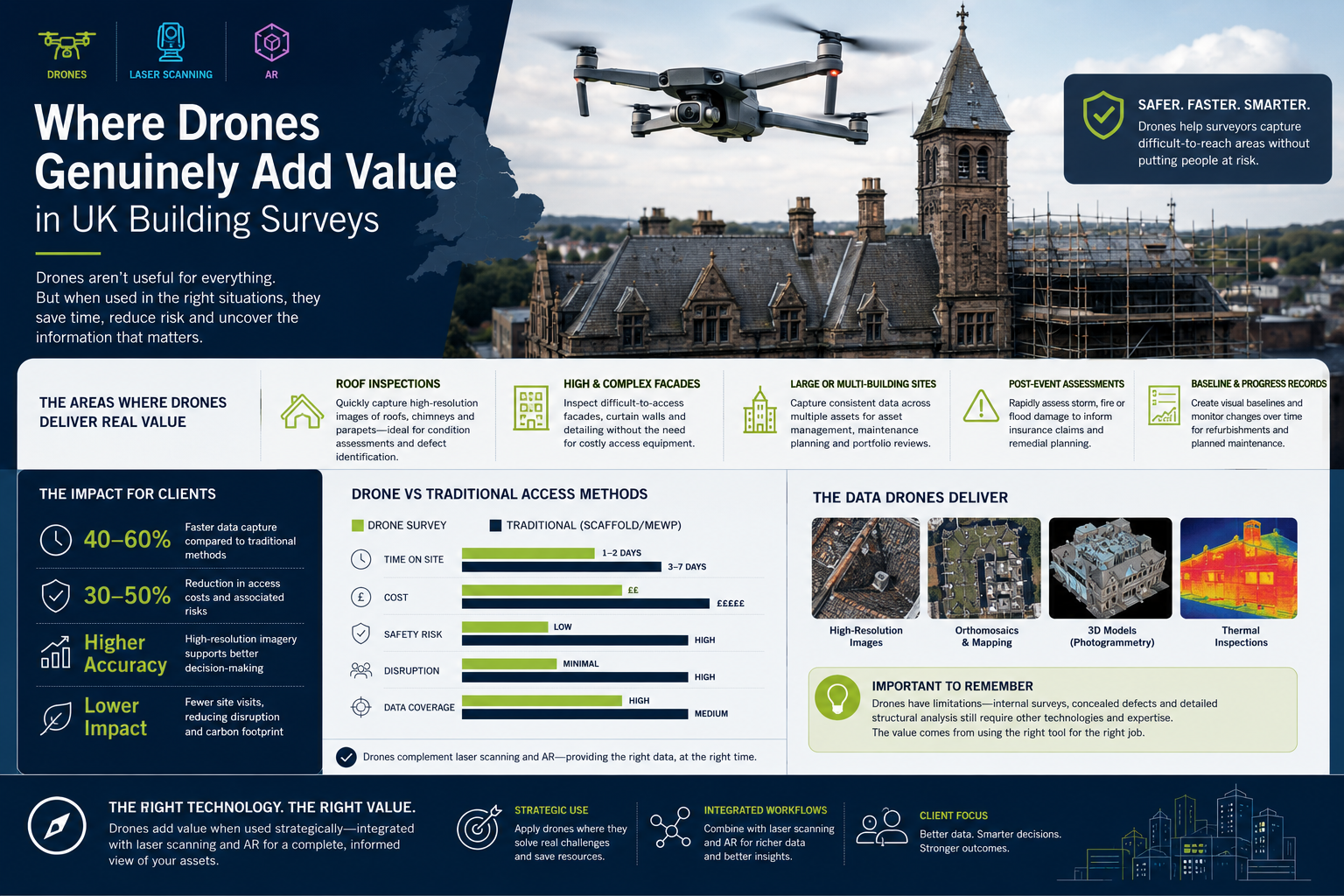
The honest answer is that drones are not universally useful in building surveys. Their value is highly context-dependent. Understanding when using drones, laser scanning and AR in UK building surveys actually moves the needle for clients requires looking at specific use cases rather than general claims.
High-Access Inspections: The Clear Win
The strongest case for drone deployment is straightforward: roofs, chimneys, parapets, high-level facades and guttering that would otherwise require scaffolding, cherry pickers or rope access. On a four-storey Victorian terrace in Knightsbridge or a large commercial warehouse, the cost of erecting scaffolding for a visual inspection alone can run to several thousand pounds. A drone survey of the same area can be completed in a fraction of the time and cost [2].
Firms such as Hummingbird Technical Services use drones for topographic mapping and LiDAR surveys across the UK, citing speed and cost-effectiveness for large or inaccessible sites as primary advantages [2]. For clients commissioning a building survey on a period property with complex rooflines, drone footage can reveal:
- Missing or slipped roof tiles
- Deteriorating lead flashings around chimney stacks
- Blocked or damaged guttering
- Cracking in parapet walls
- Vegetation growth in valleys and behind chimney breasts
When drones add limited value: On a standard two-storey semi-detached property with a simple pitched roof, a competent surveyor with binoculars and a ladder can inspect the same elements at lower total cost. Deploying a drone in this context is often a marketing exercise rather than a genuine improvement in survey quality.
Regulatory Compliance: A Real Constraint
Drone operations in the UK are governed by the Civil Aviation Authority (CAA) under the Air Navigation Order and the UK's implementation of EU drone regulations. Operators must hold appropriate CAA permissions, particularly for flights near people, buildings and congested areas — which describes most UK urban survey environments. RICS has noted that unclear use cases and integration challenges remain genuine obstacles to drone adoption in professional surveying practice [6].
Clients should always verify that their surveyor holds valid CAA operational authorisation before drone work is included in a survey scope. A drone flight conducted without proper authorisation not only creates legal exposure but may also render any resulting evidence inadmissible in dispute or litigation contexts.
Laser Scanning: Where Precision Genuinely Matters
Terrestrial laser scanning (TLS) is arguably the most mature and reliably valuable of the three technologies discussed here. When evaluating using drones, laser scanning and AR in UK building surveys, laser scanning has the strongest evidence base for improving client outcomes across a range of property types.
How Point Cloud Surveys Work
A laser scanner emits millions of laser pulses per second, measuring the distance to every surface it strikes. The result is a dense "point cloud" — a three-dimensional digital model of the scanned environment with millimetre-level accuracy. Companies including M3S Surveys Ltd capture detailed spatial information with intensity and colour values, producing comprehensive records of building geometry [1]. Castle Surveys Ltd describes this process as transforming physical environments into complete digital records [10].
That precision has direct commercial value in several scenarios:
| Use Case | Why Laser Scanning Adds Value |
|---|---|
| Heritage and listed buildings | Captures complex geometry that traditional measured surveys miss |
| Pre-acquisition surveys on large commercial properties | Provides a permanent spatial record for future reference |
| Schedules of condition | Creates an indisputable baseline for dilapidations disputes |
| Expert witness evidence | Produces CPR-compliant, measurable data for defect litigation |
| Renovation and extension planning | Enables accurate Revit or AutoCAD modelling for architects |
Integration with BIM and Revit Modelling
One of the most commercially significant applications is the integration of laser scan data with Building Information Modelling (BIM) software. Adaptive Surveys combines laser scanning with Revit modelling to produce highly accurate measured surveys, enabling architects and developers to plan projects with confidence [3]. Red Laser similarly uses AutoCAD and Autodesk Revit alongside high-definition scanning to deliver precise spatial data for complex projects [4].
For clients planning significant works — a basement conversion, a commercial fit-out, or a heritage restoration — having a laser-scanned model rather than a hand-measured drawing can prevent costly errors during design and construction. The upfront cost of scanning is typically recovered many times over if it prevents a single significant design clash or structural miscalculation.
Laser Scanning for Expert Witness and Litigation
This is an area where the technology's value is particularly clear and increasingly recognised by the courts. A recent article from Canterbury Surveyors highlights the importance of using drones and laser scanning in expert witness building surveys to produce Civil Procedure Rules (CPR)-compliant evidence for defect litigation [7]. Point cloud data provides:
- Objective, measurable records that cannot be disputed on the grounds of subjectivity
- Permanent documentation that can be re-examined years after the survey
- Precise crack width and displacement measurements that support or refute defect claims
For clients involved in dilapidations disputes, party wall matters, or construction defect litigation, commissioning a laser scan survey at the outset can be the difference between a strong and a weak evidential position. Surveyors working on specific defect surveys increasingly recommend scanning where litigation is a realistic prospect.
When Laser Scanning Is Overkill
For a standard residential Level 2 or Level 3 building survey on a typical UK house, full laser scanning is rarely justified. The cost — which can run from £1,500 to £10,000 or more depending on building size and complexity — is disproportionate to the benefit when the survey objective is simply to identify defects for a purchase negotiation. In those cases, a thorough inspection by a chartered surveyor remains the most cost-effective approach.
Augmented Reality in Building Surveys: Honest Assessment
Of the three technologies, augmented reality (AR) is the one where the gap between marketing claims and practical reality is widest in 2026. Understanding this distinction is central to any honest discussion of using drones, laser scanning and AR in UK building surveys.
What AR Promises
AR in a surveying context typically involves overlaying digital information — defect annotations, structural data, historical records, thermal imaging — onto a live view of a building, either through a headset or a tablet screen. The theoretical benefits include:
- Faster on-site data capture
- Immediate comparison of current condition against historical records
- Improved client communication through visual overlays
- Reduced risk of missed defects through guided inspection checklists
What AR Actually Delivers Today
In practice, AR applications in UK building surveys remain largely in the pilot and proof-of-concept stage. The hardware is improving — Microsoft HoloLens and similar devices are capable tools — but the software ecosystems for property-specific surveying workflows are not yet mature enough for routine deployment. Key limitations include:
- Data integration challenges: AR overlays are only as good as the underlying data. Without accurate as-built drawings or point cloud models, the overlay is of limited use.
- On-site practicalities: Headsets are cumbersome in confined spaces, lofts and roof voids — precisely the areas where surveyors spend significant time.
- Client communication value is overstated: Most clients find a well-written survey report with clear photographs more actionable than an AR demonstration.
Where AR does show genuine promise: In large commercial property inspections, facilities management, and post-construction snagging on complex developments, AR-assisted workflows are beginning to show measurable efficiency gains. For clients commissioning condition surveys on commercial properties, AR-assisted data capture may become a standard workflow component within the next three to five years.
SLAM Technology and Mobile Mapping: The Emerging Middle Ground
Between the established value of laser scanning and the still-developing promise of AR sits a category worth noting: Simultaneous Localisation and Mapping (SLAM) technology. RICS-accredited firms such as Cura Surveys deploy SLAM alongside laser scanning and drones to deliver highly accurate surveys for architects, developers and heritage consultants [5]. Survey Operations offers mobile mapping as part of a comprehensive suite that includes UAV, point cloud and construction surveys [8].
SLAM-based mobile mapping allows a surveyor to walk through a building with a handheld device, capturing spatial data continuously without the need to set up a static scanner at multiple positions. For large, complex buildings, this can significantly reduce survey time while maintaining acceptable accuracy levels.
For clients considering a building survey in London on a large commercial or mixed-use property, asking whether the surveyor uses SLAM or mobile mapping is a reasonable question that can affect both cost and turnaround time.
Matching Technology to Client Need: A Practical Framework
The central question for any client or surveyor is not "which technology is most impressive?" but "which technology solves this specific problem most cost-effectively?" The following framework helps structure that decision.
Use drones when:
- The building is over three storeys, or has complex rooflines, parapets or facades
- Scaffolding or access equipment would otherwise be required for a visual inspection
- The site is large (commercial, industrial, or multi-block residential)
- Speed of data collection is a priority
Use laser scanning when:
- The survey will inform significant design or construction work
- A permanent, measurable spatial record is required (schedules of condition, dilapidations)
- Expert witness or litigation evidence is a realistic requirement
- The building is listed, heritage-designated, or geometrically complex
Use AR when:
- The client is a large commercial operator with existing BIM or digital twin infrastructure
- The project involves ongoing facilities management rather than a one-off survey
- The surveyor has a proven, integrated AR workflow — not just the hardware
Stick with traditional methods when:
- The property is a standard residential house or flat
- The survey objective is straightforward defect identification for purchase purposes
- Budget is constrained and the technology cost cannot be justified by proportionate benefit
Clients who are uncertain about which survey level is right for their property should discuss technology options explicitly with their surveyor before instruction, rather than assuming that a higher-tech approach automatically means a better outcome.
The Cost-Benefit Reality
Technology adoption in building surveying carries a real risk of cost inflation without proportionate benefit. Angell Surveys notes that UAV-mounted LiDAR and terrestrial laser scanning provide precise 3D geometry essential for complex infrastructure projects [9] — the key word being "complex." On a straightforward residential instruction, the same tools represent unnecessary expenditure.
Clients should also be aware that survey fees incorporating drone or laser scanning work can be significantly higher than standard inspection fees. Before agreeing to a technology-enhanced scope, it is worth asking the surveyor to explain specifically how each technology component will improve the quality of the findings — and what the report would miss without it.
For buyers who are primarily concerned with using a survey to negotiate the purchase price, a thorough Level 3 building survey by a skilled chartered surveyor will almost always deliver better return on investment than a drone-and-scan package on a typical residential property.
Conclusion
The honest verdict on using drones, laser scanning and AR in UK building surveys is that the value is real but highly specific. Drones are genuinely useful for high-access inspections on tall or complex buildings. Laser scanning delivers measurable improvements in accuracy, permanence and evidential quality for commercial, heritage and litigation contexts. AR remains a technology to watch rather than one to commission routinely in 2026.
Actionable next steps for clients:
- Before instructing any survey, ask the surveyor to specify which technologies they propose to use and why — not just what they offer.
- For any property over three storeys or with complex rooflines, request confirmation that the surveyor can deploy drone inspection if scaffolding is not available.
- For commercial acquisitions, dilapidations matters or any situation where litigation is possible, commission a laser scan survey and ensure the data is CPR-compliant.
- For standard residential purchases, prioritise surveyor experience and RICS accreditation over technology features.
- Request sample outputs — drone footage, point cloud visualisations, or AR demonstrations — before committing to a premium technology fee.
The best building surveyors in the UK use technology as a precision instrument, not a sales tool. Clients who understand the difference will make better decisions and get more value from every survey instruction.
References
[1] m3s-surveys – https://www.m3s-surveys.com/?utm_source=openai
[2] hummingbirdts.co.uk – https://hummingbirdts.co.uk/?utm_source=openai
[3] Laser Scanning – https://adaptivesurveys.co.uk/services/laser-scanning/?utm_source=openai
[4] Services – https://redlaser.co.uk/services/?utm_source=openai
[5] curasurveys.co.uk – https://curasurveys.co.uk/?utm_source=openai
[6] Drones Uk Regulations Building Surveyors – https://ww3.rics.org/uk/en/journals/built-environment-journal/drones-uk-regulations-building-surveyors.html?utm_source=openai
[7] Drones And Laser Scanning In Expert Witness Building Surveys Cpr Compliant Evidence For Defect Litigation 2026 – https://www.canterburysurveyors.com/blog/drones-and-laser-scanning-in-expert-witness-building-surveys-cpr-compliant-evidence-for-defect-litigation-2026/?utm_source=openai
[8] survops.co.uk – https://www.survops.co.uk/?utm_source=openai
[9] Lidar – https://angellsurveys.com/services/lidar/?utm_source=openai
[10] Point Cloud Surveys – https://castlesurveys.co.uk/services/point-cloud-surveys/?utm_source=openai