
78% of major surveying firms have now implemented Common Data Environments (CDEs) as their primary delivery and collaboration infrastructure — a figure that has doubled in just three years [5]. That single statistic tells a profound story about how rapidly the property surveying sector is leaving behind the era of emailed PDFs, version-confusion, and delayed approvals.
Cloud-Based Platforms for Collaborative Property Surveying: Instant Access and Real-Time Updates represent far more than a software upgrade. They are a fundamental rethinking of how surveyors, engineers, architects, developers, and clients interact with spatial data. Instead of waiting days for a revised drawing to arrive in an inbox, every stakeholder can now open a browser, see the latest 3D model, leave a comment, and approve a revision — all in real time.
This article breaks down exactly how these platforms work, what they deliver, and why adopting them is no longer optional for competitive surveying practices in 2026.
Key Takeaways 📌
- 78% of major surveying firms now use Common Data Environments (CDEs) for collaboration and delivery [5].
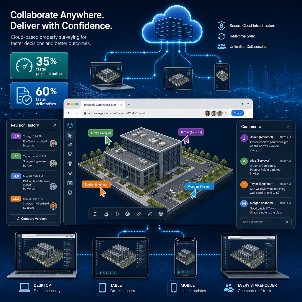
- Cloud platforms reduce project timelines by an average of 35% and operational costs by 22% [4].
- Real-time digital twins and browser-based 3D visualization have become standard features in 2026 [1].
- BIM integration with cloud surveying platforms has increased by 47% since 2024 [1].
- Surveyors can now deliver outputs 60% faster using cloud collaboration tools [2].
How Cloud-Based Platforms Are Transforming Property Surveying
The shift to cloud infrastructure in property surveying is not just about storage. It is about changing the entire workflow — from data capture in the field to final sign-off by a client.
From Static PDFs to Live, Browser-Based 3D Models
For decades, the standard surveying deliverable was a flat PDF or a CAD file. These formats had a critical flaw: the moment a file was sent, it began to go out of date. Any revision required a new file, a new email, and a new round of confusion about which version was current.
Cloud-Based Platforms for Collaborative Property Surveying: Instant Access and Real-Time Updates solve this at the root. Modern platforms now offer 3D visualization directly in the browser — no specialist software required. A developer can open a link on a tablet, rotate a 3D model of a property boundary, zoom into a specific defect flagged by the surveyor, and approve the next phase of work within minutes [1].
💬 "The ability to view, annotate, and approve survey data in a browser — without downloading anything — has compressed what used to be a two-week approval cycle into a single afternoon."
This matters enormously for time-sensitive transactions. When a buyer has had their offer accepted and needs a building survey completed quickly, cloud-enabled delivery means the report and supporting visuals reach all parties simultaneously and in their most current form.
Real-Time Revision Syncing: Eliminating Version Chaos
One of the most damaging inefficiencies in traditional surveying workflows is version conflict — when two parties are working from different iterations of the same document. Cloud platforms eliminate this entirely through real-time revision syncing.
Every change made to a survey document, drawing, or model is instantly reflected for all users. Revision histories are automatically logged, so it is always clear what changed, when, and who made the update. This is particularly valuable for complex projects such as stock condition surveys covering large property portfolios, where dozens of documents may be updated simultaneously.
Key benefits of real-time syncing:
| Feature | Traditional Workflow | Cloud Platform |
|---|---|---|
| Revision tracking | Manual, error-prone | Automatic, timestamped |
| File distribution | Email attachments | Instant link sharing |
| Version control | Multiple conflicting copies | Single source of truth |
| Stakeholder access | Sequential | Simultaneous |
| Approval speed | Days to weeks | Hours |
The Role of Common Data Environments and Digital Twins
Common Data Environments (CDEs): The Backbone of Collaboration
A Common Data Environment is a centralised, cloud-hosted workspace where all project information — drawings, models, reports, communications, and approvals — lives in one place. According to February 2026 industry analysis, CDEs are now used by 78% of major surveying firms not just as storage but as active collaboration tools that fundamentally change how spatial information integrates with broader project data [5].
CDEs serve several critical functions:
- 📂 Centralised document management — one location for all project files
- 🔔 Automated notifications — stakeholders are alerted when documents are updated or require approval
- 🔐 Role-based access control — clients, engineers, and surveyors each see what is relevant to them
- 📊 Audit trails — every action is logged for accountability and dispute resolution
- 🌐 Integration with GIS and BIM — spatial data connects directly to design and planning tools
For property assessment projects involving multiple disciplines, a CDE means an architect, a structural engineer, and a chartered surveyor can all work from the same live dataset without ever sending a single attachment.
Digital Twins: Surveying Data That Stays Alive
Perhaps the most significant technological leap in cloud-based surveying is the real-time digital twin. These are high-fidelity, interactive 3D models that update continuously as new data is collected in the field [1].
Rather than a static snapshot of a property at a single point in time, a digital twin reflects the current state of a site. As a surveyor captures new measurements or flags a structural defect, that information flows directly into the model. Developers, engineers, and planners can then visualise how a land parcel or building behaves under various conditions — including stress modelling, drainage analysis, and boundary scenarios.
Digital twins are particularly powerful when combined with drone-captured data and LiDAR scanning, which feed high-resolution point clouds directly into cloud platforms for immediate stakeholder review [8].
BIM Integration: Bridging Surveying and Design
The integration of Building Information Modeling (BIM) with cloud surveying platforms has increased by 47% since 2024 [1]. This means land surveyors are no longer operating in isolation from the design team. Geospatial data captured during a survey is now routinely fed into BIM models, giving architects and engineers an accurate, real-world foundation for their designs.
For construction surveying projects, this integration eliminates the costly errors that arise when design teams work from outdated or inaccurate site data. A live connection between the survey and the BIM model means that any change on site is reflected in the design environment within minutes.
Cloud-Based Platforms for Collaborative Property Surveying: Business Impact and Adoption

The Numbers Behind the Shift
The business case for cloud-based collaborative surveying is compelling and well-documented. Industry analysis from Q1 2026 shows that cloud-enabled platforms are:
- Reducing project timelines by an average of 35% [4]
- Cutting operational costs by 22% through seamless data sharing [4]
- Enabling surveyors to deliver outputs 60% faster across different teams [2]
- Eliminating the need for expensive local processing hardware, with 63% of surveying firms having migrated data processing entirely to the cloud [6]
These are not marginal gains. A 35% reduction in project timeline on a complex commercial survey can mean the difference between hitting a contractual deadline and facing a penalty clause.
Stakeholder Communication: Built Into the Platform
One of the most underappreciated benefits of cloud platforms is the integrated communication layer. Rather than managing a separate email thread, phone calls, and meeting notes alongside the technical documents, modern platforms embed communication directly into the workflow.
Surveyors can tag specific areas of a drawing with a comment. An engineer can respond with a query. A client can approve a section — all within the same interface, with every exchange automatically linked to the relevant document version.
This is especially valuable for specific defect surveys where precise communication about the location and severity of an issue is critical. Instead of describing a crack in a written email and hoping the recipient understands the reference, a surveyor can pin a comment directly onto the relevant point in the 3D model.
Faster Project Approvals: The End of the PDF Bottleneck
The traditional approval process in property surveying followed a predictable and frustrating pattern:
- Surveyor completes fieldwork
- Report is drafted and formatted
- PDF is emailed to client
- Client reviews, queries, and emails back
- Revised PDF is sent
- Process repeats until approval
With cloud platforms, this linear chain is replaced by a parallel, real-time process. Multiple stakeholders review simultaneously. Comments are resolved in real time. Approvals are logged automatically. The result is not just faster — it is fundamentally more reliable, with a complete audit trail that protects all parties.
For first-time buyers navigating a building survey in London, this means receiving a clear, interactive report that is easier to understand and act upon — rather than a dense PDF that requires multiple follow-up calls to interpret.
Challenges and Considerations
Adopting cloud-based surveying platforms is not without its challenges. Practices should be aware of:
- Data security — sensitive property data must be protected under GDPR and industry standards
- Connectivity requirements — remote sites may have limited internet access, requiring offline sync capabilities
- Training investment — staff must be upskilled to use new platforms effectively
- Integration costs — connecting cloud tools with existing CAD, GIS, and accounting systems requires planning
- Client readiness — some clients, particularly in residential markets, may need guidance on accessing and using cloud-delivered reports
Despite these considerations, the productivity and quality gains consistently outweigh the transition costs for firms that plan their adoption carefully [6].
What to Look for in a Cloud Surveying Platform
When evaluating platforms, surveying firms and property professionals should prioritise:
✅ Browser-based 3D viewing — no client software installation required
✅ Real-time sync — changes visible to all stakeholders instantly
✅ CDE compliance — meets ISO 19650 standards for information management
✅ BIM integration — direct connection to design and planning tools
✅ Mobile field capture — works on tablets and smartphones on site
✅ Granular access controls — different permission levels for different stakeholders
✅ Automated audit trails — every action logged and timestamped
✅ GIS compatibility — integrates with geographic information systems for spatial analysis
Conclusion: Actionable Next Steps for Surveyors and Property Professionals
Cloud-Based Platforms for Collaborative Property Surveying: Instant Access and Real-Time Updates are not a future trend — they are the current standard for competitive, efficient surveying practice in 2026. The data is unambiguous: faster timelines, lower costs, better communication, and more reliable outcomes.
Here are concrete next steps for different audiences:
For surveying firms:
- Audit your current workflow to identify where version conflicts and approval delays occur most frequently
- Evaluate CDE platforms against ISO 19650 compliance requirements
- Pilot a cloud platform on one project type before full rollout
- Invest in staff training alongside software adoption
For property developers and investors:
- Ask your surveyor whether they use a cloud-based CDE for project delivery
- Request browser-based access to survey data rather than PDF-only reports
- Explore how digital twin capabilities can support planning applications
For home buyers and sellers:
- Understand that modern property surveys can now be delivered as interactive, cloud-accessible reports
- Ask your surveyor how you will receive and review your report
- Use cloud-delivered data to support price negotiation strategies with clear, visual evidence
The surveying industry's digital transformation is accelerating. Those who embrace cloud collaboration tools now will be better positioned to deliver faster approvals, stronger client relationships, and more profitable projects — while those who cling to static PDFs will find themselves increasingly left behind.
References
[1] Future Land Surveying 2026 – https://haller-blanchard.com/future-land-surveying-2026/
[2] Innovations In Land Surveying Equipment Whats New This Year – https://metricop.com/blogs/land-surveying/innovations-in-land-surveying-equipment-whats-new-this-year
[3] Land Survey Drafting Automation – https://alada.us/land-survey-drafting-automation/
[4] Land Surveying Market 2026 Deep Dive Trends Growth Aslve – https://www.linkedin.com/pulse/land-surveying-market-2026-deep-dive-trends-growth-aslve
[5] Doubling Down On Digital – https://amerisurv.com/2026/02/01/doubling-down-on-digital/
[6] Revolutionizing Land Surveying How Ai And Machine Learning Are Predicting Risks And Automating Workflows In 2026 – https://www.canterburysurveyors.com/blog/revolutionizing-land-surveying-how-ai-and-machine-learning-are-predicting-risks-and-automating-workflows-in-2026/
[7] Land Surveying The Modern Art Of Accurate Measurement – https://www.faro.com/en/Resource-Library/Article/Land-Surveying-The-Modern-Art-of-Accurate-Measurement
[8] Top Emerging Land Surveying Technologies Shaping 2026 Drones Ai And Beyond – https://nottinghillsurveyors.com/blog/top-emerging-land-surveying-technologies-shaping-2026-drones-ai-and-beyond
[9] 2026 Alta Nsps Land Title Survey Updates What Surveyors Must Know To Mitigate Risks – https://wimbledonsurveyors.com/2026-alta-nsps-land-title-survey-updates-what-surveyors-must-know-to-mitigate-risks/
[10] Digital Trends Operations Survey – https://www.pwc.com/us/en/services/consulting/supply-chain-operations/library/digital-trends-operations-survey.html