

{"cover":"Professional landscape format (1536×1024) hero image with bold text overlay: 'Reality Capture Goes Mainstream: Tools Every Property Surveyors Need in 2026' in extra large 72pt white bold sans-serif font with dark drop shadow, centered upper-third composition. Background shows a professional property surveyor in high-visibility vest operating a Leica BLK360 laser scanner on a residential street, with a drone visible in the sky above and a glowing point cloud visualization overlaid in teal and orange. Color scheme: deep navy blue, white, and vivid teal accents. Magazine cover quality, editorial style, high contrast.","content":["Detailed landscape format (1536×1024) infographic-style illustration showing a side-by-side comparison of traditional surveying clipboard and tape measure versus modern reality capture tools: a 3D laser scanner emitting colorful point cloud data, a drone with LiDAR payload, and a tablet displaying a photogrammetry mesh model of a residential property. Clean white background with teal and navy color accents, labeled callouts for each tool, professional technical diagram aesthetic, property surveying focus.","Detailed landscape format (1536×1024) editorial photograph of a property surveyor kneeling beside a FARO or Leica tripod-mounted 3D scanner in a Victorian terraced house interior, with a laptop screen showing Autodesk ReCap Pro point cloud registration interface. Warm interior lighting contrasts with cool blue scanner laser beams. Secondary inset shows a drone aerial view of a residential rooftop with thermal imaging overlay. Professional, documentary photography style, shallow depth of field on scanner hardware.","Detailed landscape format (1536×1024) top-down aerial drone perspective over a residential housing development site showing multiple properties with overlaid digital twin wireframe models in glowing blue lines, GPS coordinate markers, and accuracy percentage annotations. A surveyor on the ground holds a tablet displaying ArcGIS Reality interface with Gaussian splat 3D visualization. Color palette: deep charcoal ground, vivid cyan digital overlays, white annotation text. Futuristic yet grounded, technical illustration meets real-world photography composite."]
Fewer than five years ago, a 3D laser scanner capable of capturing a full building interior cost upwards of £50,000 and required a dedicated operator with months of specialist training. By 2026, comparable hardware fits in a backpack, costs a fraction of that price, and syncs wirelessly to cloud platforms that small surveying firms can access on a monthly subscription. That shift is not gradual evolution — it is a structural change in how property data is collected, processed, and delivered to clients.
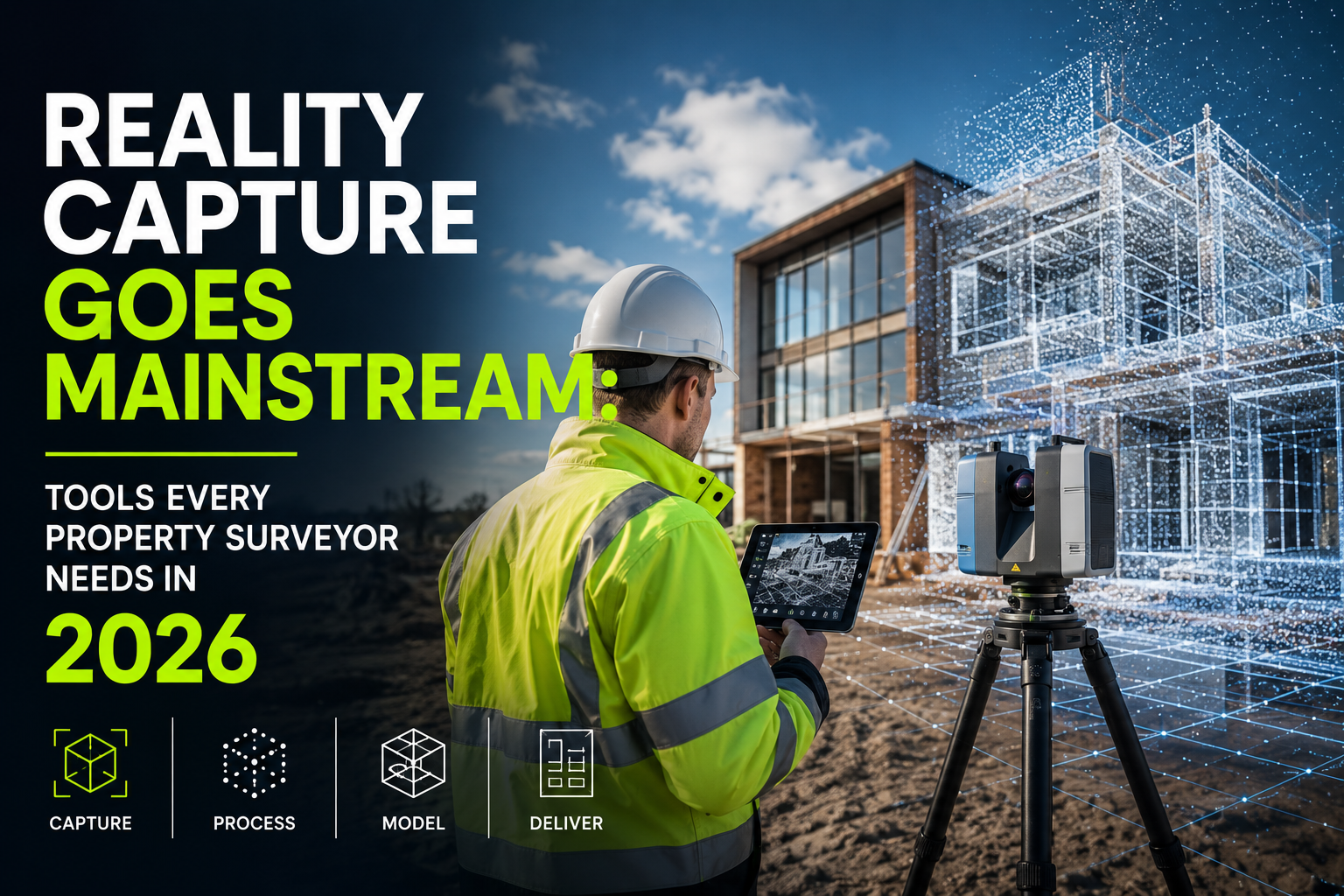
Reality Capture Goes Mainstream: Tools Every Property Surveyor Needs in 2026 is no longer a headline reserved for large infrastructure consultancies. The technology has moved decisively into residential and commercial property surveying, and firms of every size now need a clear understanding of which tools deliver real value, how they integrate with existing workflows, and where the precision gains justify the investment.
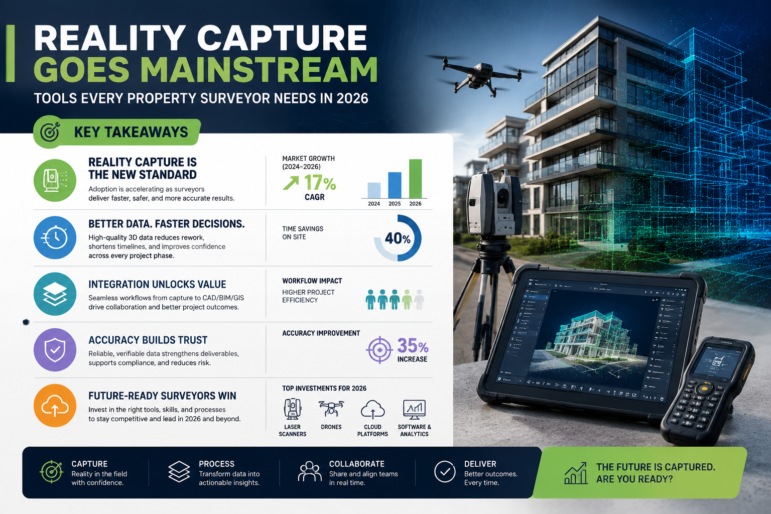
Key Takeaways
- Reality capture technology — including 3D laser scanning, drone photogrammetry, and mobile mapping — has become accessible and affordable for small surveying firms in 2026.
- Tools such as the Leica BLK360 SE, FARO Blink, Autodesk ReCap Pro 2026, and DroneDeploy are delivering measurable gains in inspection speed, data accuracy, and client reporting quality.
- AI-powered processing and digital twin integration are transforming raw point cloud data into actionable property intelligence.
- Drone-based reality capture has expanded beyond site documentation into thermal inspections, roof assessments, and stock condition surveys.
- Choosing the right tool depends on survey type, site access constraints, budget, and required output format.
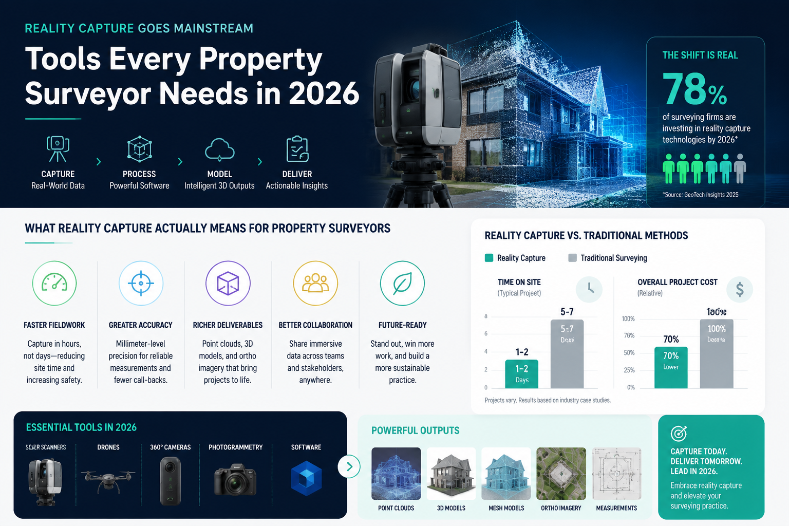
What Reality Capture Actually Means for Property Surveyors
Reality capture is the process of recording the physical dimensions, surfaces, and spatial relationships of a property using sensors — laser, photographic, or both — and converting that data into a digital representation. The outputs range from simple 2D floor plans to full point clouds, photogrammetric meshes, and interactive digital twins.
For a property surveyor working on a Level 2 homebuyer report or a full RICS building survey, reality capture does not replace professional judgement. It augments it. A surveyor who walks a property with a handheld scanner or deploys a drone over a complex roof structure gathers spatial evidence that a tape measure and a camera simply cannot replicate.
The geospatial industry is undergoing a transformation in which AI, digital twins, and reality capture technologies are fundamentally changing how data is collected and analysed [4]. That transformation has now reached the day-to-day work of residential and commercial property surveyors across the UK.
From Niche to Necessary
Three converging factors have driven mainstream adoption in 2026:
- Hardware cost reduction — Entry-level scanners and drone payloads have dropped significantly in price.
- Cloud processing — Platforms now handle computationally intensive point cloud registration and mesh generation remotely, removing the need for high-spec workstations.
- Accessible software — Tools like Autodesk ReCap Pro 2026 offer improved 3D modelling from photographs or laser scans, helping surveyors transform real-world objects into digital assets with a relatively short learning curve [9].
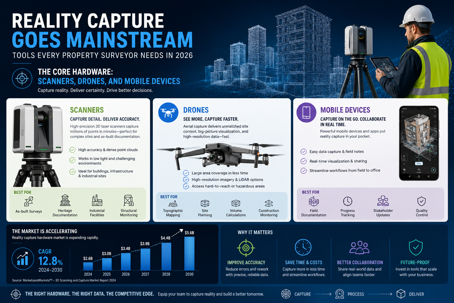
The Core Hardware: Scanners, Drones, and Mobile Devices
Understanding the tool landscape is the first practical step. The market in 2026 divides broadly into three categories: terrestrial laser scanners, drone-based capture systems, and mobile/handheld devices.
Terrestrial Laser Scanners
Leica BLK360 SE has emerged as a benchmark instrument for property and building assessments, providing detailed spatial data that improves decision-making in real estate and facilities management [5]. Its compact form factor makes it practical for residential properties where space is limited, and its automated registration reduces post-processing time significantly.
Leica Cyclone REGISTER 360 PLUS 2026 complements the BLK360 SE by enhancing point cloud registration workflows. The 2026 release introduced improved geotag handling and faster automated registration, which directly reduces the time between site visit and deliverable [8].
FARO Blink, launched in May 2025, takes a different approach. Rather than requiring a separate registration workflow, Blink combines 3D capture with automated processing via the FARO Sphere XG Digital Reality Platform, creating a more streamlined end-to-end solution suited to surveyors who need rapid turnaround [10].
| Tool | Best Use Case | Key Advantage |
|---|---|---|
| Leica BLK360 SE | Residential interiors, heritage buildings | Compact, high accuracy |
| FARO Blink | Commercial properties, rapid surveys | Automated processing pipeline |
| Leica Cyclone REGISTER 360 PLUS 2026 | Multi-scan projects | Fast point cloud registration |
| Autodesk ReCap Pro 2026 | Photo-to-3D workflows | Broad file format compatibility |
Drone-Based Reality Capture
Drone-based reality capture became a mainstream element of construction and property workflows by early 2026, augmenting processes from site documentation to thermal inspections [6]. For property surveyors, the most relevant applications include:
- Roof condition assessments — Drones access areas that are unsafe or impractical to reach physically, reducing liability and improving surveyor safety.
- Thermal imaging — Drone-mounted thermal cameras identify heat loss, moisture ingress, and insulation deficiencies invisible to the naked eye.
- Site progress monitoring — Relevant for monitoring surveys on development projects.
- Photogrammetric mapping — Overlapping aerial images processed into orthomosaics and 3D models.
Cairn Homes deployed DroneDeploy's reality capture technology across more than 25 active residential sites by April 2026, reporting improvements in both inspection speed and data accuracy [3]. That scale of adoption by a residential developer signals that drone-based capture has moved well beyond pilot projects.
DroneDeploy integrates directly with major GIS and BIM platforms, making it practical for surveyors who need outputs compatible with client-side systems. Its automated flight planning reduces operator skill requirements, which matters for small firms without dedicated drone pilots.
Mobile and Handheld Devices
For surveyors who need rapid capture without the setup time of a tripod-mounted scanner, mobile mapping solutions have matured considerably. Smartphones with LiDAR sensors (available on recent Apple and Android flagships) combined with apps like Matterport Capture or Pix4Dcatch now produce room-level point clouds suitable for floor plan generation and basic condition recording.
In February 2026, Esri and Pix4D launched a terrestrial mapping workflow with augmented reality visualisation, enabling field teams to capture 3D asset data via mobile apps and synchronise it directly with ArcGIS Online [7]. This workflow is particularly relevant for surveyors conducting specific defect surveys or damp surveys where precise location tagging of defects adds significant value to the report.
Software, Platforms, and AI Integration
Hardware captures the data; software turns it into something a client can use. The platform landscape in 2026 has consolidated around a smaller number of powerful tools, with AI-driven automation becoming a standard feature rather than a premium add-on.
Autodesk ReCap Pro 2026
Autodesk ReCap Pro 2026 remains the most widely used post-processing tool for surveyors working with both photogrammetric and laser scan data [9]. Its 2026 release improved automated feature extraction, making it faster to generate measured drawings and 3D models from raw scan data. Integration with Autodesk Construction Cloud means outputs can be shared directly with architects, engineers, and project managers without format conversion.
ArcGIS Reality and Gaussian Splats
In November 2025, Esri introduced Gaussian splat rendering in ArcGIS Reality, a technique that significantly improves the visual quality and navigability of 3D property models [1]. For surveyors producing client-facing deliverables — particularly for heritage properties or complex commercial assets — Gaussian splats produce photorealistic walkthroughs from point cloud data without the heavy mesh processing previously required.
"The introduction of Gaussian splats in ArcGIS Reality represents a meaningful step forward in how surveyors communicate spatial findings to non-technical clients."
Trimble Reality Capture Platform
In September 2024, Trimble launched a platform service integrated with Trimble Connect, designed to facilitate secure sharing and collaboration on large reality capture datasets [2]. For surveying firms working on multi-site instructions or sharing data with client teams, this addresses a genuine practical problem: point cloud files are large, and secure, version-controlled sharing has historically been cumbersome.
RealityCapture (Epic Games)
RealityCapture became free for non-commercial use in 2026, making high-fidelity photogrammetry accessible to smaller firms and sole traders who previously could not justify the licence cost. For commercial surveying work, the paid tier remains competitively priced, and the software's processing speed and output quality are widely regarded as best-in-class for photogrammetric workflows.
AI-Powered Defect Detection
Several platforms now incorporate machine learning models trained to identify common property defects — cracking patterns, damp staining, spalling masonry — directly within point cloud or photographic datasets. This does not replace a qualified surveyor's assessment, but it does accelerate the review process and reduces the risk of overlooking defects in large datasets. For stock condition surveys covering multiple units, AI-assisted defect flagging can meaningfully reduce per-unit assessment time.
Practical Integration: Matching Tools to Survey Types
Reality Capture Goes Mainstream: Tools Every Property Surveyor Needs in 2026 is most useful when understood through the lens of specific survey types rather than as a general technology trend. Different instructions call for different capture approaches.
Homebuyer and Building Surveys
For a standard RICS homebuyer survey or a Level 3 building survey, reality capture tools add value primarily in three areas:
- Roof and elevation documentation — Drone capture provides photographic evidence of roof condition without requiring access equipment.
- Floor plan accuracy — Handheld or tripod scanners generate measured floor plans faster and more accurately than manual measurement.
- Defect location recording — Geotagged defect photos linked to a 3D model give clients a clearer understanding of where issues are located within the property.
Party Wall and Boundary Surveys
For boundary surveys and party wall instructions, precise spatial data is essential. A terrestrial laser scan of a party wall structure or boundary feature provides an unambiguous record of position and condition at a specific point in time — valuable both for the initial agreement and for any subsequent dispute resolution.
Condition and Dilapidations Surveys
Dilapidations surveys and condition assessments benefit significantly from reality capture because the deliverable needs to be defensible. A point cloud record of a property's condition at lease end, combined with photographic documentation, provides a robust evidential base that is far harder to dispute than written descriptions alone.
Safety, Efficiency, and the Business Case for Small Firms
The safety argument for reality capture is straightforward. Drone deployment eliminates the need for surveyors to access unsafe roofs, inspect high-level facades, or work in confined spaces. For firms where a single surveyor injury can disrupt the entire operation, this risk reduction has real financial value.
The efficiency argument is equally compelling. A surveyor using a Leica BLK360 SE can capture a complete interior scan of a typical three-bedroom house in under two hours, with the point cloud registered and ready for measurement extraction before the end of the working day. Manual measurement of the same property to the same level of detail would take considerably longer and produce less accurate results.
Key efficiency gains reported by early adopters in 2026:
- Reduced return visits to site for additional measurements
- Faster production of measured drawings and floor plans
- Improved report quality and client satisfaction scores
- Stronger evidential records for dispute resolution
For small firms considering the investment, the practical starting point is a phased approach: begin with drone capture for roof and elevation work (lower hardware cost, immediate safety benefit), then evaluate terrestrial scanning for interior work as project volumes justify the expenditure.
Working with RICS-qualified surveyors who have already integrated these tools into their practice is also a useful way to understand realistic workflow impacts before committing to hardware purchases.
Conclusion: Actionable Next Steps for Property Surveyors in 2026
Reality Capture Goes Mainstream: Tools Every Property Surveyor Needs in 2026 is not a prediction — it is a description of the current market. The tools are available, the costs are manageable, and the client expectations are shifting. Surveyors who continue to rely solely on traditional methods risk falling behind on both quality and efficiency.
Actionable steps to take now:
- Audit current workflows — Identify the survey types where return visits, measurement disputes, or access limitations are causing the most friction. These are the highest-priority candidates for reality capture integration.
- Start with drone capture — The entry cost is lower, the safety benefit is immediate, and the learning curve for platforms like DroneDeploy is manageable for most practitioners.
- Trial RealityCapture or Autodesk ReCap Pro 2026 — Both offer accessible entry points for photogrammetric processing. Free or trial tiers allow workflow testing before financial commitment.
- Evaluate cloud collaboration platforms — Trimble Connect and ArcGIS Online both support large dataset sharing, which matters as point cloud files become standard deliverables.
- Engage with RICS guidance — Professional body guidance on reality capture deliverables and competency standards is evolving; staying current protects both professional standing and client relationships.
The property surveying firms that will lead their markets in the next five years are those building reality capture competency now, while the technology is still differentiating rather than merely expected.
References
[1] Whats New In Arcgis Reality November 2025 – https://www.esri.com/arcgis-blog/products/arcgis-pro/imagery/whats-new-in-arcgis-reality-november-2025?utm_source=openai
[2] New Reality Capture Platform Service Leverages Trimble Connect Maximize Value – https://www.nasdaq.com/press-release/new-reality-capture-platform-service-leverages-trimble-connect-maximize-value?utm_source=openai
[3] Cairn Homes DroneDeploy Reality Capture Residential Portfolio – https://www.pbctoday.co.uk/news/digital-construction-news/construction-technology-news/cairn-rollout-dronedeploys-reality-capture-across-residential-portfolio/160654/?utm_source=openai
[4] Advanced Technology – https://journals.cices.org/ces/geospatial-engineering-2025-2026/features/advanced-technology?utm_source=openai
[5] Blk360se Realestate Property Asset Management Reality Capture – https://survey.crkennedy.com.au/blogs/news/2026/Apr/2/blk360se-realestate-property-assest-management-reality-capture?utm_source=openai
[6] Drone Reality Capture Ramps Up To Augment Construction Site Workflows – https://canada.constructconnect.com/dcn/news/technology/2026/02/drone-reality-capture-ramps-up-to-augment-construction-site-workflows?utm_source=openai
[7] AR News Esri Pix4D Terrestrial Mapping ArcGIS – https://www.auganix.org/ar-news-esri-pix4d-terrestrial-mapping-arcgis/?utm_source=openai
[8] Cyclone Register 360 Plus 2026 Fafx Geotags Point Cloud Registration – https://stablewarez.com/shop/cyclone-register-360-plus-2026-fafx-geotags-point-cloud-registration/?utm_source=openai
[9] Autodesk ReCap Pro Overview – https://www.autodesk.com/products/recap/overview.14?utm_source=openai
[10] Introducing Blink By FARO Technologies Reality Capture Reimagined – https://www.dronesworldmag.com/introducing-blink-by-faro-technologies-reality-capture-reimagined/?utm_source=openai


