

Firms using disconnected surveying tool stacks lose an estimated 30% of project time to manual data re-entry and format conversion — a figure that becomes catastrophic on multi-stakeholder infrastructure projects where six or more teams share the same dataset. The case for Interoperable Hardware in Surveying: Streamlining Data Sharing Across Teams in 2026 has never been stronger, and the industry is responding with new standards, smarter hardware ecosystems, and cloud platforms that finally allow GNSS receivers, total stations, and laser scanners to speak the same language regardless of manufacturer.
Key Takeaways
- Interoperable hardware ecosystems — combining compatible GNSS, total stations, and laser scanners — directly reduce data errors in multi-stakeholder surveying projects.
- ISO 9849:2026, released in May 2026, standardizes vocabulary across geodetic instruments, making cross-manufacturer communication more reliable.
- A three-layer stack (hardware, software, cloud) is the most effective model for building a seamless surveying workflow in 2026.
- Standards such as ASTM E57 and ISO/TS 15143-4 provide the technical foundation for hardware interoperability in 3D imaging and grade control.
- Cloud-based Common Data Environments (CDEs) are the critical bridge between field capture and multi-team data sharing.
Why Hardware Interoperability Matters More Than Ever in 2026
Modern surveying projects rarely involve a single firm. A typical infrastructure scheme in 2026 might include a principal contractor, a specialist geotechnical team, a highways authority, a utilities company, and an environmental consultant — each carrying their own preferred instruments and software. When those tools cannot exchange data cleanly, errors multiply.
The core problem is format fragmentation. A Leica laser scanner outputs data in a different native format than a Trimble GNSS receiver. A Topcon total station may log observations in a proprietary file structure that requires conversion before it enters a shared CAD environment. Every conversion step introduces the risk of coordinate shift, metadata loss, or version conflict.
Digital transformation research confirms that firms adopting interoperable tools and cloud platforms are gaining measurable competitive advantages by enabling seamless data exchange and reducing manual data entry errors [3]. The shift is not merely technological — it is strategic. Teams that resolve the interoperability problem earlier in a project lifecycle consistently deliver more accurate outputs and spend less time in error-correction cycles.
Understanding what a surveyor does across different roles and responsibilities helps clarify why data compatibility is so central: surveyors are increasingly expected to act as data managers as much as field technicians, and that dual role demands tools that communicate without friction.
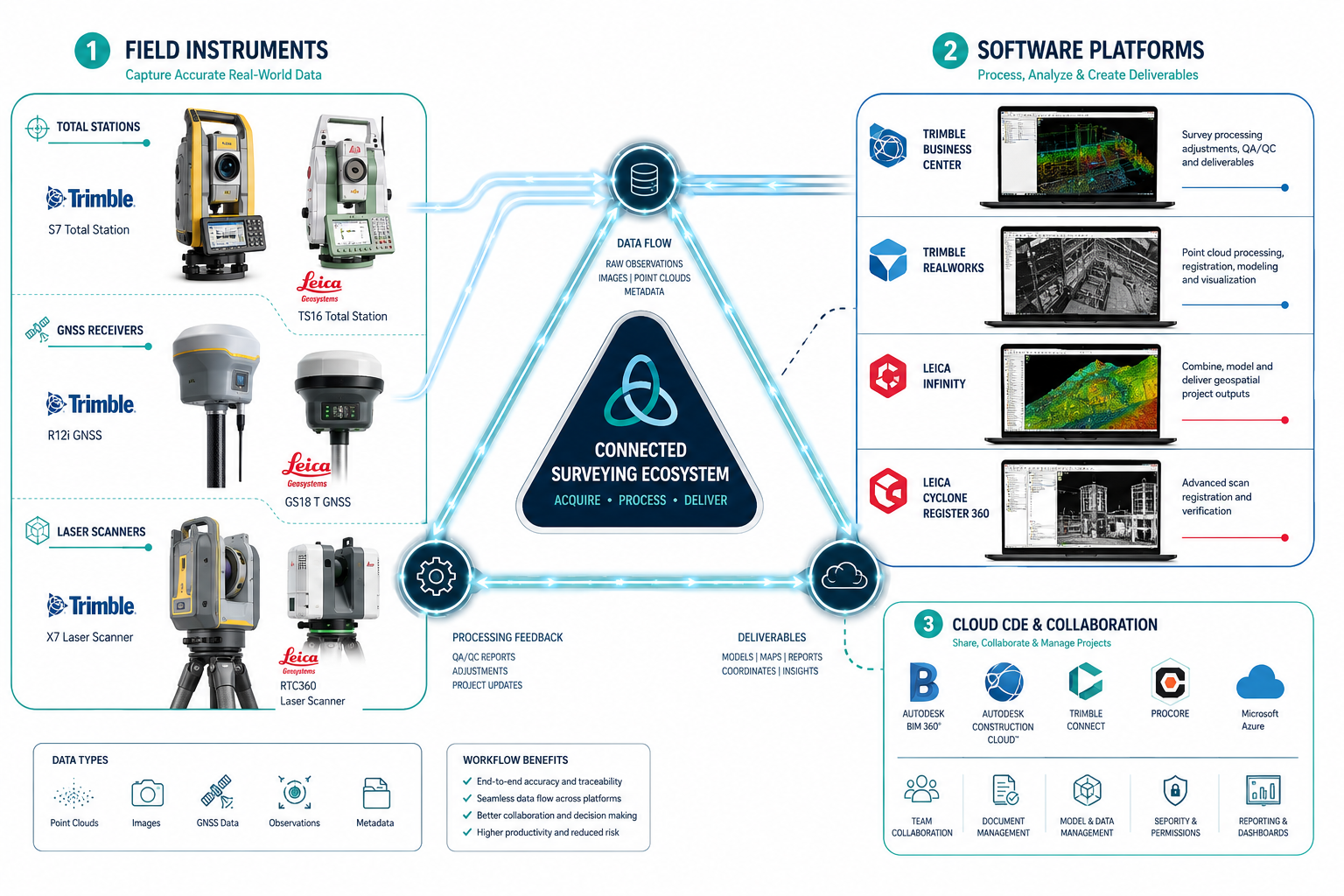
The Three-Layer Stack: Hardware, Software, and Cloud
Building a seamless surveying ecosystem in 2026 requires thinking in three distinct but connected layers. Each layer must be compatible with the others, and the weakest link in the chain determines the overall quality of data sharing.
Layer 1: Field Hardware
The hardware layer is where raw data originates. The dominant instrument categories are:
- Total stations — measure angles and distances with millimetre precision
- GNSS/GPS receivers — provide absolute positioning referenced to global coordinate systems
- Laser scanners — capture dense 3D point clouds of structures and terrain
- Airborne sensors — drones and UAVs equipped with LiDAR or photogrammetric cameras
Major manufacturers — Trimble, Leica, Topcon, and Sokkia — each produce instruments that perform these functions excellently. The challenge is that each manufacturer has historically prioritised proprietary data formats to lock customers into their ecosystem [2]. Interoperability, in this context, means choosing hardware that supports open or widely adopted exchange formats, or investing in middleware that bridges the gap.
The U.S. Army's Automated Integrated Survey Instrument (AISI) offers an instructive model. This field survey package integrates electronic theodolites, distance meters, and data recorders into a single unit designed for interoperability with GPS survey suites and other military systems [6]. The civilian lesson is clear: integration by design, rather than integration as an afterthought, produces far more reliable data pipelines.
Layer 2: Processing Software
Once field data is captured, it moves into processing platforms. Common tools in 2026 include:
| Software Platform | Primary Function | Manufacturer |
|---|---|---|
| Trimble Business Center | Survey data processing, adjustment | Trimble |
| Leica Infinity | Field-to-office data management | Leica Geosystems |
| Topcon Magnet Office | Total station and GNSS processing | Topcon |
| AutoCAD Civil 3D | Civil engineering design and CAD | Autodesk |
| Esri ArcGIS Pro | Geospatial analysis and mapping | Esri |
The critical requirement at this layer is that software can import and export standard formats — LandXML, DXF, GeoJSON, LAS for point clouds — without data loss. When construction surveying teams from different firms must share deliverables, agreed-upon exchange formats prevent the costly rework that arises from incompatible file types.
Layer 3: Cloud Platforms and Common Data Environments
The cloud layer is where multi-stakeholder collaboration actually happens. Common Data Environments (CDEs) such as Trimble Connect and Autodesk Construction Cloud serve as the single source of truth for a project [2]. All teams upload to and download from the same environment, eliminating the version control chaos that plagues email-based data sharing.
Platforms like ATIS.cloud and SurveyTransfer have emerged specifically for geospatial datasets, allowing surveyors to upload large scan files and share browser-accessible links with clients who do not have specialist software installed [5]. This lowers the barrier to collaboration significantly, particularly when clients or non-technical stakeholders need to review survey outputs.
Standards Driving Interoperable Hardware in Surveying: Streamlining Data Sharing Across Teams in 2026

Standards are the invisible infrastructure that makes hardware interoperability possible. Without agreed definitions and data schemas, even well-intentioned integration efforts collapse under the weight of ambiguity.
ISO 9849:2026
On 4 May 2026, the International Organization for Standardization released ISO 9849:2026, titled "Optics and optical instruments — Geodetic and surveying instruments — Vocabulary" [1]. This standard provides a unified vocabulary for geodetic and surveying instruments, covering distance meters, levels, theodolites, GNSS devices, total stations, laser scanners, and airborne sensors.
The practical impact is significant. When a project team in London and a subcontractor in Manchester use the same definitions for terms like "instrument height," "reference epoch," or "point cloud density," the risk of miscommunication drops sharply. Standardised vocabulary is the foundation on which interoperable data exchange is built.
ASTM E57 for 3D Imaging Systems
The ASTM E57 standard, developed by the ASTM E57 3D Imaging committee, provides guidelines for evaluating 3D imaging systems including laser scanners and optical range cameras [7]. It defines performance metrics and data formats that allow outputs from different scanner manufacturers to be compared and combined within the same workflow.
For teams using multiple scanner brands on a single project — a common scenario in large infrastructure surveys — ASTM E57 compliance means point cloud data can be merged without manual reformatting.
ISO/TS 15143-4 for 3D Grade Control
The Association of Equipment Manufacturers (AEM) has been actively involved in developing ISO/TS 15143-4, a standard for 3D grade control interoperability [4]. This standard facilitates efficient collaboration among various 3D grade control systems on a single worksite, enabling excavators, graders, and survey instruments from different manufacturers to share positional data in real time.
On a road construction project, for example, a Trimble machine control system and a Topcon grade control unit can both reference the same digital terrain model when both conform to ISO/TS 15143-4. The result is fewer staking errors and faster earthworks progress.
FGDC Geospatial Standards
The Federal Geographic Data Committee (FGDC) maintains a suite of geospatial standards designed to improve data interoperability and reusability across governmental and private entities [8]. These standards govern coordinate reference systems, metadata schemas, and data quality reporting — all of which affect how surveying data is shared between organisations with different internal systems.
Key insight: Standards compliance is not a bureaucratic overhead — it is the mechanism by which hardware from different manufacturers becomes genuinely interoperable in the field.
GNSS Compatibility and Real-Time Data Sharing
GNSS technology sits at the heart of most modern surveying workflows, and its interoperability characteristics have a direct impact on data accuracy across multi-stakeholder projects.
Real-Time Network (RTN) surveying uses a network of fixed reference stations to broadcast corrections to rover units in the field [9]. The rover — typically a GNSS receiver carried by a field surveyor — applies these corrections in real time, achieving centimetre-level accuracy without the need for a dedicated base station on site.
The interoperability benefit is substantial. When multiple teams on the same project subscribe to the same RTN service, their GNSS observations are all corrected against the same reference frame. This eliminates the systematic offsets that arise when different teams use different base station setups, which is one of the most common sources of coordinate discrepancy in multi-contractor projects.
For property boundary work — an area where even small coordinate errors can have significant legal consequences — RTN compatibility between field instruments is not optional. Teams working on property boundary matters or boundary dispute resolution cases must ensure their GNSS equipment references the same network corrections to produce defensible, consistent results.
Practical Challenges and How to Overcome Them

Even with the right standards and hardware in place, real-world interoperability faces practical obstacles. Understanding these challenges helps teams plan more effectively.
Challenge 1: Proprietary Format Lock-In
Many manufacturers still default to proprietary formats for raw data storage. The solution is to specify open-format export as a contract requirement at project outset. Requiring LandXML, LAS, or GeoJSON delivery from all subcontractors eliminates the conversion problem before it starts.
Challenge 2: Coordinate Reference System Mismatches
Different teams may work in different coordinate reference systems — national grid versus local assumed coordinates, for example. Establishing a project-wide coordinate reference system in the project brief, and verifying that all instruments are configured to match, is essential. This is especially relevant for construction surveying projects spanning multiple sites or jurisdictions.
Challenge 3: Software Version Incompatibility
Processing software updates can change how files are read and written. Standardising software versions across a project team, or agreeing on a stable exchange format that is version-agnostic, mitigates this risk.
Challenge 4: Workflow Integration for Non-Technical Stakeholders
Clients and project managers often need to review survey data without access to specialist software. Cloud platforms that offer browser-based viewing — such as those built on the ATIS.cloud model [5] — solve this problem by making data accessible to all stakeholders regardless of their technical setup.
Challenge 5: Skills Gaps in Interoperable Workflows
Hardware and software interoperability only delivers value when field teams understand how to configure instruments for compatible output. Investment in training — particularly around GNSS network configuration, point cloud export settings, and CDE upload protocols — is as important as the technology itself.
Teams considering a homebuyers survey or more complex structural assessment should look for surveyors who demonstrate fluency in these integrated workflows, as the quality of data sharing directly affects the reliability of the final report.
Selecting the Right Interoperable Hardware Stack for Your Team
Choosing hardware for a multi-stakeholder project in 2026 requires evaluating instruments against several interoperability criteria, not just technical performance.
Evaluation checklist for interoperable surveying hardware:
- Supports open data export formats (LandXML, LAS, GeoJSON, DXF)
- Compatible with RTN GNSS correction services
- Certified or tested against relevant standards (ISO 9849:2026, ASTM E57, ISO/TS 15143-4)
- Integrates with at least one major CDE (Trimble Connect, Autodesk Construction Cloud)
- Manufacturer provides documented API or SDK for third-party integration
- Field software allows direct cloud upload without desktop intermediary
Teams working across London and the surrounding regions can benefit from consulting professional surveyor services that already operate with interoperable hardware stacks, reducing the onboarding time required to align with project data standards.
For those seeking to understand the full scope of survey options before commissioning work, the guide on which home survey is right for you provides a useful starting point for matching survey type to project requirements.
The Business Case for Interoperability
The return on investment from interoperable hardware is measurable across three dimensions:
1. Reduced rework costs. When data flows cleanly between instruments, software, and cloud environments, the volume of field revisits caused by coordinate errors or format failures drops significantly. On large infrastructure projects, this can represent savings of tens of thousands of pounds.
2. Faster project delivery. Eliminating manual data conversion and re-entry accelerates the path from field capture to client-ready deliverable. Teams report that interoperable workflows can reduce data processing time by 20-40% compared to fragmented tool stacks [3].
3. Lower liability exposure. Errors in survey data — particularly in boundary definition or structural assessment — carry legal and financial consequences. Interoperable systems that maintain a clean audit trail from instrument to final output provide stronger documentation in the event of a dispute.
For property professionals considering the financial implications of survey findings, understanding the average price reduction after a survey illustrates how accurate, well-documented survey data directly affects negotiating outcomes.
Conclusion
Interoperable Hardware in Surveying: Streamlining Data Sharing Across Teams in 2026 is no longer an aspirational goal — it is a technical and commercial necessity for any firm operating in multi-stakeholder project environments. The combination of updated standards like ISO 9849:2026, robust hardware from manufacturers supporting open formats, RTN GNSS networks, and cloud-based CDEs creates a complete ecosystem for error-resistant data sharing.
Actionable next steps for surveying teams and project managers:
- Audit your current hardware stack against the interoperability checklist above and identify format or protocol gaps.
- Specify open data exchange formats (LandXML, LAS, GeoJSON) as a contractual requirement for all subcontractors on your next project.
- Subscribe to a regional RTN GNSS correction service and verify that all field instruments are configured to use the same network.
- Adopt a CDE as the single source of truth for project data, and ensure all team members — including non-technical stakeholders — have access.
- Review ISO 9849:2026 terminology with your team to ensure consistent vocabulary across all project documentation.
- Invest in training that covers interoperable workflow configuration, not just instrument operation.
Teams that act on these steps now will be better positioned to win and deliver complex, multi-party projects as client expectations for data quality and transparency continue to rise throughout 2026 and beyond.
References
[1] Iso 9849 2026 – https://standards.iteh.ai/catalog/standards/iso/37ac1b1f-21b2-4a50-bb62-c9ff210da4de/iso-9849-2026
[2] Interoperable Hardware And Software Stacks Building Seamless Surveying Ecosystems For 2026 – https://kingstonsurveyors.com/interoperable-hardware-and-software-stacks-building-seamless-surveying-ecosystems-for-2026/
[3] Digital Transformation In Surveying 2026 Cloud Platforms Interoperable Tools And Workforce Strategies – https://wimbledonsurveyors.com/digital-transformation-in-surveying-2026-cloud-platforms-interoperable-tools-and-workforce-strategies/
[4] Aem Assists In The Ongoing Development Of 3d Grade Control Interoperability Standard – https://www.aem.org/news/aem-assists-in-the-ongoing-development-of-3d-grade-control-interoperability-standard
[5] Surveying – https://www.atis.cloud/use-cases/surveying
[6] Aisi Line Of Sight Survey Total Station – https://www.agc.army.mil/Media/Fact-Sheets/Fact-Sheet-Article-View/Article/4323452/aisi-line-of-sight-survey-total-station/
[7] Astm E57 3d Imaging Systems – https://www.nist.gov/publications/astm-e57-3d-imaging-systems
[8] Standards – https://www.fgdc.gov/standards
[9] Real Time Network – https://water.usgs.gov/osw/gps/real-time_network.html


