
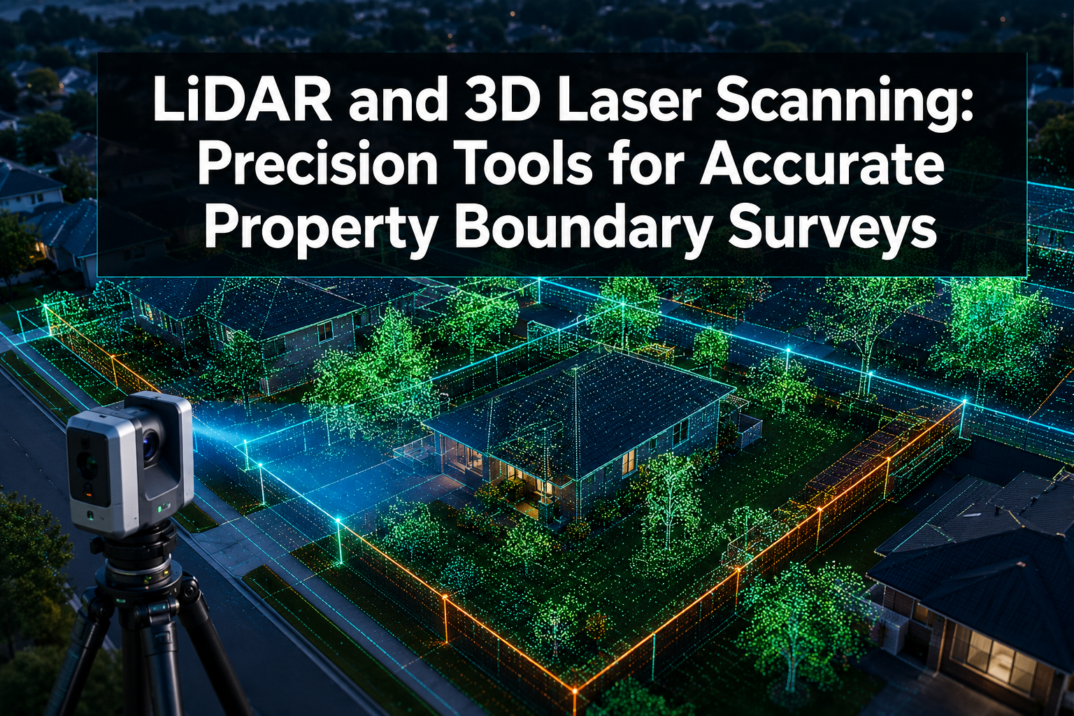
Boundary disputes cost UK property owners an average of £12,000 to £50,000 in legal fees when they escalate to court — yet many of these conflicts stem from measurement errors that modern technology can now eliminate before they begin. LiDAR and 3D Laser Scanning: Precision Tools for Accurate Property Boundary Surveys represent a fundamental shift in how surveyors capture, record, and defend spatial data. These technologies do not merely improve on traditional methods; they redefine what accuracy means in a legal and development context.
Key Takeaways
- LiDAR and 3D laser scanning can capture millions of spatial data points per second, delivering sub-centimetre accuracy for property boundary delineation.
- Point cloud data generated by these tools creates a legally defensible, permanent digital record of boundary positions and topographic features.
- Hybrid workflows combining terrestrial, mobile, and airborne LiDAR are becoming the 2026 precision standard for built-environment surveys.
- The technology dramatically reduces fieldwork time, minimises human error, and supports dispute resolution with irrefutable visual evidence.
- RICS-qualified surveyors using LiDAR-enhanced methods provide clients with a higher standard of due diligence, especially for complex or high-value properties.
How LiDAR Technology Works in Property Surveying
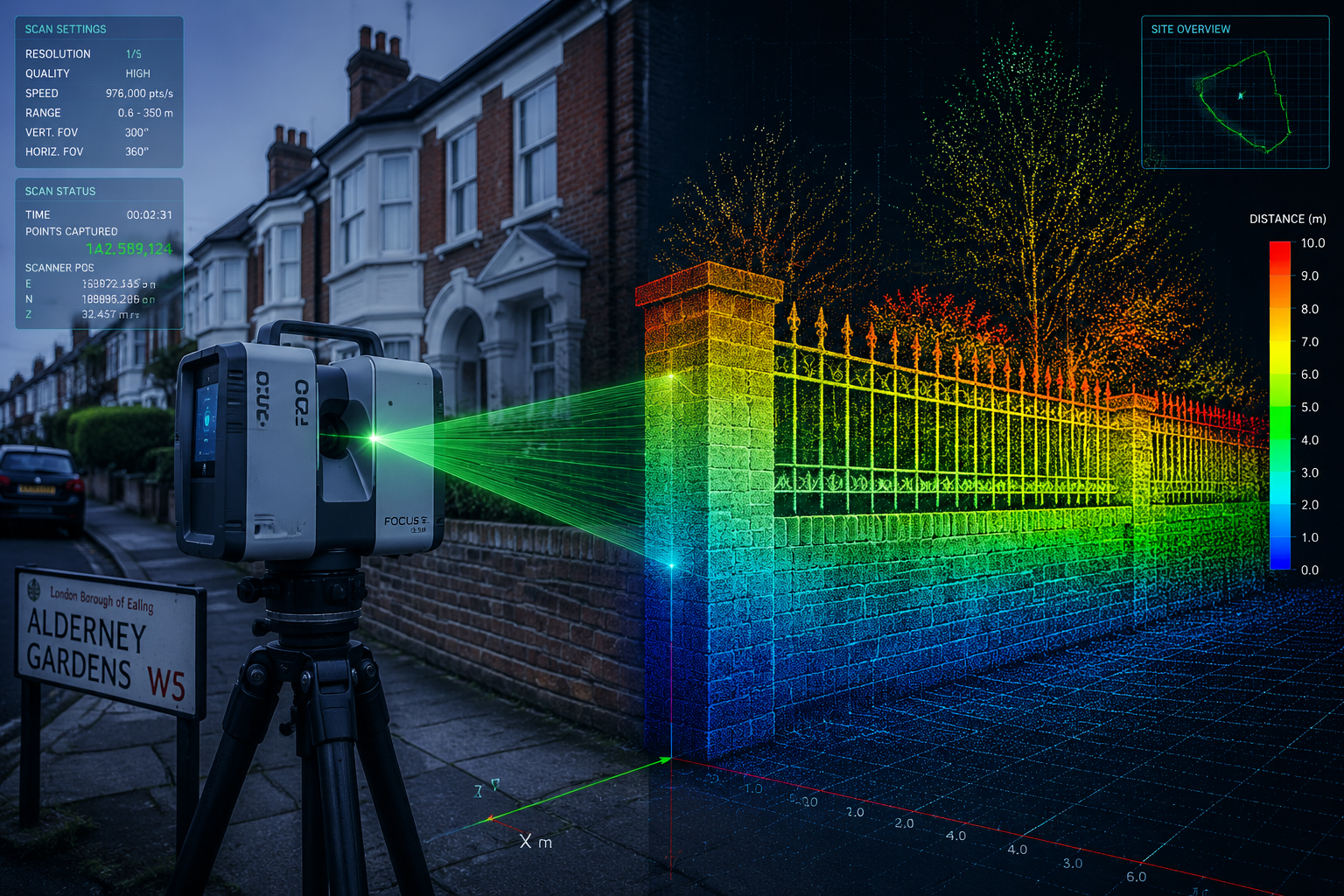
LiDAR stands for Light Detection and Ranging. At its core, the technology fires rapid pulses of laser light at surfaces and measures the time each pulse takes to return to the sensor. By calculating the travel time of millions of pulses per second, the system builds a highly detailed three-dimensional model of the surrounding environment — known as a point cloud [1].
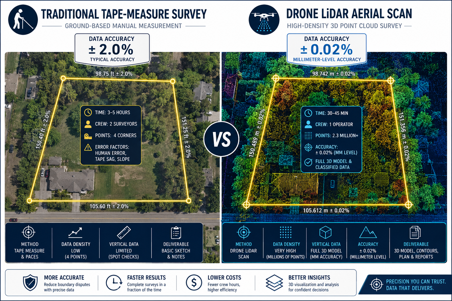
For property boundary surveys, this capability is transformative. A traditional survey relies on physical measurements taken at discrete points. A LiDAR scan captures everything simultaneously: walls, fences, trees, kerb edges, building facades, and ground-level changes. The resulting point cloud can be interrogated from any angle, at any time, without returning to the site.
Key components of a LiDAR survey system include:
- A laser emitter and receiver unit (the scanner head)
- An inertial measurement unit (IMU) to track orientation
- A GNSS/GPS receiver for georeferencing
- Data processing software to convert raw pulses into usable 3D models
Modern scanners, such as those produced by Riegl and Leica, now achieve angular resolutions and range accuracies that were unthinkable a decade ago [5][9]. STMicroelectronics has recently unveiled compact direct time-of-flight LiDAR chips that bring this precision into smaller, more portable form factors [4], making site deployment faster and less disruptive to residents and neighbouring properties.
"A single LiDAR scan session can replace days of traditional fieldwork while producing a richer, more defensible dataset."
The Role of 3D Laser Scanning in Capturing Spatial Data for Boundary Delineation
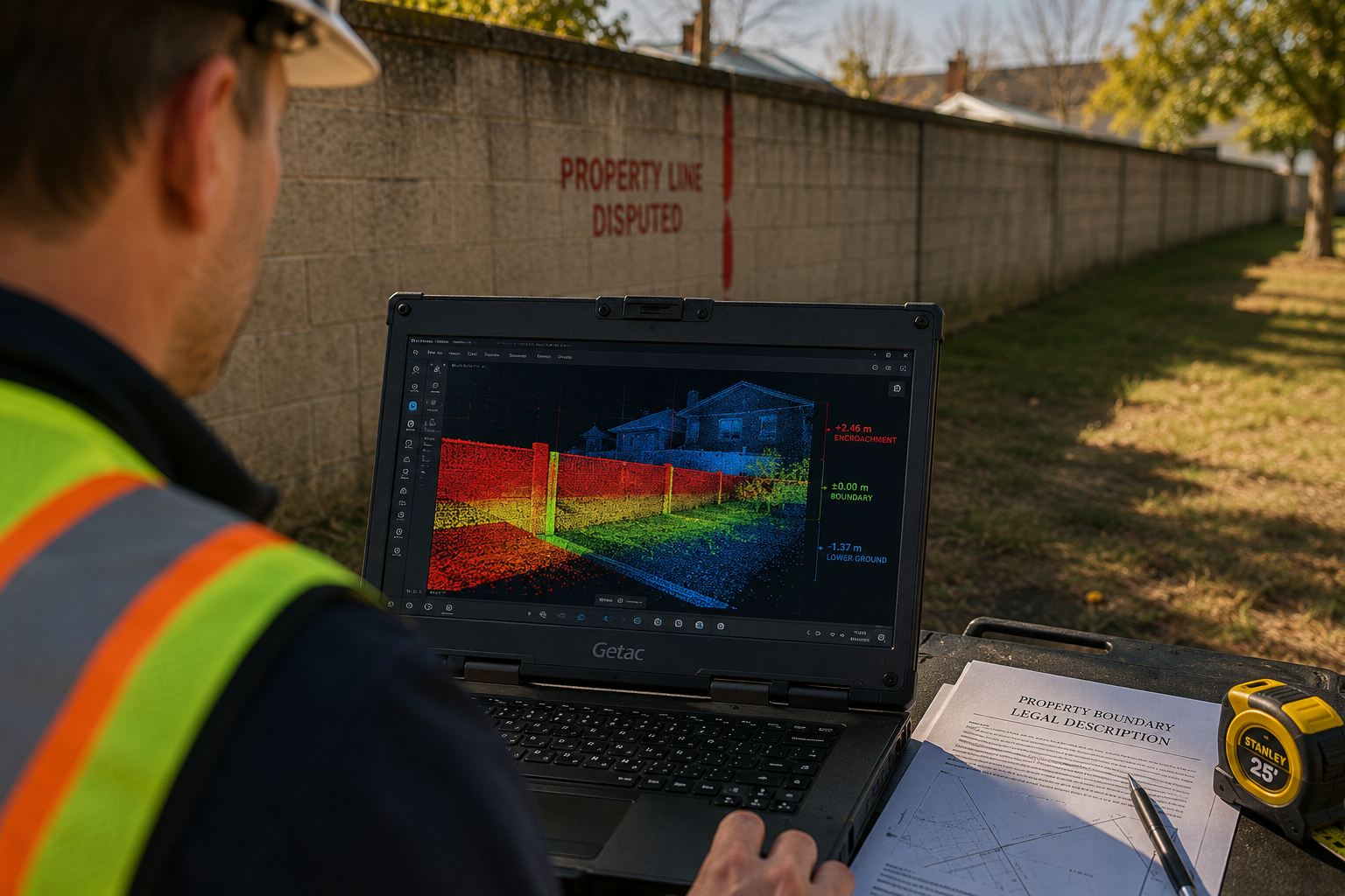
Understanding why LiDAR and 3D Laser Scanning are precision tools for accurate property boundary surveys requires examining what spatial data actually means in a legal context. A boundary is not simply a line on a title plan. It is a physical feature — a wall, a hedge, a fence post — that exists in three-dimensional space, subject to subsidence, encroachment, and historical change.
Point Cloud Data and Legal Defensibility
When a 3D laser scan is conducted, the resulting point cloud contains coordinate data for every captured surface. Each point carries X, Y, and Z values tied to a real-world coordinate system. This means boundary positions can be measured, re-measured, and compared against historical records with complete precision.
Research published in the International Journal of Applied Earth Observation and Geoinformation confirms that LiDAR-derived spatial datasets significantly outperform conventional survey methods in detecting subtle ground-level deformations and feature boundaries [2]. This matters enormously when a boundary wall has shifted by even a few centimetres — an amount invisible to the naked eye but legally significant.
For anyone involved in a boundary dispute, understanding the average cost of a boundary dispute underscores why investing in precise scanning technology at the outset is far more cost-effective than litigation.
Topographic Capture: Beyond the Flat Plan
Traditional title plans are two-dimensional. They cannot represent slope, elevation change, or the three-dimensional position of a retaining wall. LiDAR changes this entirely.
What 3D laser scanning captures that 2D plans cannot:
| Feature | Traditional Survey | LiDAR / 3D Scan |
|---|---|---|
| Horizontal boundary position | Yes | Yes |
| Vertical elevation changes | Partial | Full |
| Overhanging structures | No | Yes |
| Subsurface feature indicators | No | Partial |
| Tree canopy encroachment | No | Yes |
| Historical comparison baseline | No | Yes |
This topographic richness is especially valuable on sloped sites, properties with complex garden boundaries, or urban plots where neighbouring buildings overhang or abut at unusual angles. For properties in areas like Islington or Chelsea, where Victorian terraces sit on irregular plots with shared party walls, this level of detail is not a luxury — it is essential.
Hybrid LiDAR Workflows: The 2026 Precision Standard
The most significant development in property survey technology in 2026 is the maturation of hybrid LiDAR workflows — combining terrestrial, mobile, and airborne scanning platforms into a single, integrated data capture process [3].
Terrestrial LiDAR
A static tripod-mounted scanner captures high-density point clouds at ground level. This is ideal for recording boundary walls, fence lines, and building facades at millimetre accuracy. Multiple scan positions are merged using registration software to eliminate blind spots.
Mobile LiDAR
A scanner mounted on a vehicle or backpack-worn harness moves through a site continuously, capturing data in motion. Mobile systems are faster than static setups and excel at covering long boundary runs, access roads, and extended perimeter features [6]. Recent advances in sensor miniaturisation have made mobile LiDAR units significantly lighter and more affordable [4].
Airborne and Drone-Mounted LiDAR
Unmanned aerial vehicles (UAVs) carrying LiDAR sensors can survey large or inaccessible areas from above. Airborne LiDAR is particularly effective for capturing topography across entire development sites, identifying drainage patterns, and verifying boundary positions against aerial reference data [8]. The combination of drone LiDAR with ground-based scanning creates a seamless top-down and ground-level dataset.
Why hybrid workflows matter for property boundary surveys:
- They eliminate the data gaps that any single platform leaves
- They allow cross-verification between aerial and ground-level measurements
- They produce a single unified coordinate system for the entire property
- They reduce the number of site visits required, lowering disruption and cost
This evolution is well documented by industry analysts tracking the trajectory of 3D scanning technology [10], and it aligns with what RICS-accredited surveyors are increasingly expected to deliver on complex or high-value instructions.
Practical Applications: Where LiDAR Adds the Most Value
LiDAR and 3D laser scanning are not universally necessary for every property transaction. However, there are specific scenarios where their application provides a clear and measurable advantage.
Boundary Dispute Resolution
When neighbours disagree about where a boundary lies, a LiDAR-derived point cloud provides objective, court-admissible evidence. The scan records the physical position of every boundary feature at a specific date and time. This is far more persuasive than a hand-drawn sketch or a scaled plan from a title register. For those navigating boundary dispute resolution, a LiDAR survey conducted by a qualified professional can shorten the dispute timeline significantly.
Pre-Development Due Diligence
Before any construction project begins, accurate boundary data is essential. Encroachments discovered after foundations are poured are expensive to remedy. LiDAR surveys conducted before planning applications are submitted allow architects and engineers to design with confidence. This is particularly relevant for party wall matters, where the exact position of a shared wall determines legal obligations under the Party Wall Act 1996.
High-Value Property Transactions
For premium properties — particularly in areas such as Knightsbridge or Richmond — the cost of a LiDAR boundary survey is negligible relative to the transaction value. Buyers and their solicitors increasingly request this level of precision as part of comprehensive due diligence. A thorough RICS building survey combined with LiDAR boundary data provides the most complete picture of a property's condition and legal extent.
Schedule of Condition Surveys
LiDAR scanning is also being integrated into schedule of condition surveys conducted before neighbouring construction work begins. The scan creates an irrefutable baseline record of a property's condition and boundary features, protecting owners from false claims of construction damage.
Accuracy, Standards, and What to Expect from a LiDAR Survey
Not all LiDAR surveys are equal. The accuracy of the final dataset depends on the quality of the equipment, the skill of the operator, and the rigour of the data processing workflow.
Typical accuracy benchmarks for property boundary surveys:
- Terrestrial static LiDAR: 2–6 mm at 10–50 m range
- Mobile LiDAR: 10–30 mm depending on speed and conditions
- Drone-mounted LiDAR: 20–50 mm at typical survey altitudes
For legal boundary work, terrestrial scanning remains the gold standard due to its superior accuracy at close range. Mobile and airborne systems are best used to complement ground-level data rather than replace it.
Surveyors should adhere to RICS guidance on measured surveys and ensure all data is georeferenced to the Ordnance Survey National Grid. Deliverables typically include:
- A registered point cloud file (e.g., .las or .e57 format)
- A 2D boundary plan derived from the scan
- A 3D model or cross-section drawings where required
- A written report interpreting the findings
Understanding the difference between survey levels is important when commissioning work. The key differences between Level 2 and Level 3 surveys provide useful context for how detailed an instruction needs to be based on the property type and risk level.
Limitations and Considerations
LiDAR and 3D laser scanning are powerful, but they are not without constraints.
Known limitations include:
- Dense vegetation: Laser pulses struggle to penetrate thick hedgerows, which can obscure boundary features beneath. Multiple scan passes and ground-truthing are often required.
- Reflective surfaces: Highly polished materials (glass, water) can produce noisy or incomplete data.
- Cost: High-quality terrestrial LiDAR equipment is expensive, and specialist processing software requires trained operators. This cost is passed to the client, though it remains proportionate for complex or high-value cases.
- Regulatory permissions: Drone-mounted LiDAR requires Civil Aviation Authority (CAA) authorisation in the UK, adding a planning step to airborne survey projects.
- Data volume: A single scan session can generate hundreds of gigabytes of data, requiring robust storage and processing infrastructure.
Despite these limitations, the technology continues to evolve rapidly. Next-generation LiDAR sensors are achieving higher pulse rates, longer ranges, and better performance in difficult conditions [7], and the cost curve continues to fall as adoption increases [3].
Conclusion
LiDAR and 3D Laser Scanning: Precision Tools for Accurate Property Boundary Surveys are no longer emerging technology — they are the 2026 benchmark for serious boundary work. The ability to capture millions of spatial data points, create legally defensible point cloud records, and integrate terrestrial, mobile, and airborne data into a single unified model has transformed what property surveyors can deliver.
Actionable next steps for property owners, developers, and legal professionals:
- Commission a LiDAR boundary survey early — before a dispute arises, before planning is submitted, and before contracts exchange on high-value transactions.
- Engage an RICS-qualified surveyor with demonstrable experience in 3D scanning workflows. Ask to see sample deliverables before instructing.
- Request a hybrid workflow on larger or more complex sites to ensure no boundary feature is missed.
- Store the point cloud data securely — it becomes a permanent legal record that can be revisited years later if a dispute emerges.
- Pair boundary scanning with a full structural assessment where appropriate, to ensure both the legal extent and physical condition of the property are fully understood.
For properties across London and the surrounding region, working with experienced local surveyors who understand both the technology and the legal framework is essential. Whether the property is in Wimbledon, Ealing, or Barnet, precision boundary data protects asset value and prevents costly disputes before they begin.
References
[1] Future 3D Laser Scanning North America – https://iscano.com/laser-scanning-lidar-future-trends/future-3d-laser-scanning-north-america/
[2] S1569843222003442 – https://www.sciencedirect.com/science/article/pii/S1569843222003442
[3] 3D Laser Scanning in 2026 Major Technology and Workflow Shifts – https://www.enginyring.com/en/blog/3d-laser-scanning-in-2026-major-technology-and-workflow-shifts
[4] STMicroelectronics Unveils Compact Direct Time-of-Flight LiDAR – https://finance.yahoo.com/technology/ai/articles/stmicroelectronics-unveils-compact-direct-time-060000481.html
[5] Innovation in Every Pulse: Riegl's New LiDAR Technologies – https://www.riegl.com/en-austria/news-insights/article/innovation-in-every-pulse-riegls-new-lidar-technologies
[6] Marine Applications of 3D Laser Scanning – https://lidarnews.com/marine-applications-of-3d-laser-scanning/
[7] LiDAR Evolution: How Next-Gen Technology Is Reshaping Autonomous Systems – https://www.eetimes.com/lidar-evolution-how-next-gen-technology-is-reshaping-autonomous-systems/
[8] Recent Developments in Airborne LiDAR – https://www.gim-international.com/content/article/recent-developments-in-airborne-lidar-2
[9] LiDAR Roundup: New Sensors from Leica, Riegl, Faro, Teledyne – https://www.geoweeknews.com/blogs/lidar-roundup-new-sensors-leica-riegl-faro-teledyne
[10] What Is the Future of 3D Laser Scanning – https://www.gp-radar.com/article/what-is-the-future-of-3d-laser-scanning


