
Fewer than one in five homebuyers commission a survey that looks beyond the building itself, yet the ground beneath a property, the watercourses nearby and the drainage infrastructure serving it can each affect value, insurability and safety far more than a cracked render or a tired boiler. Understanding how surveyors use maps and location data to assess flooding, access, drainage and development risk is the starting point for any buyer, developer or lender who wants a complete picture of what they are acquiring.
Key Takeaways
- A chartered surveyor's desk study begins before the site visit, drawing on national flood maps, LiDAR terrain data, Ordnance Survey layers and planning records to build a location risk profile.
- Official flood maps cover fluvial, coastal and surface-water sources but routinely omit localised groundwater and drainage risks, a specialist surveyor fills that gap with site-level data.
- Flood zone classification directly affects planning permission, mortgage availability and buildings insurance premiums.
- Drainage assessment covers both on-site disposal and the capacity of public sewers and ordinary watercourses to receive run-off from the site.
- Access constraints, substandard road widths, rights of way, shared drives, are identified through mapping before the surveyor sets foot on the property.
The Desk Study: What Surveyors Do Before They Arrive on Site
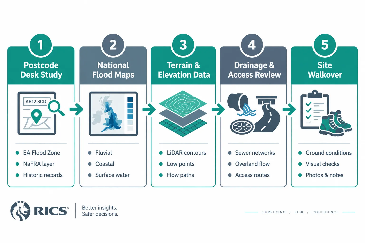
A professional survey is not simply a physical inspection. The desk study, the pre-visit research phase, can take as long as the site visit itself, and it is where maps and location data do the heaviest lifting.
National flood maps are the first port of call. The Environment Agency publishes flood-zone maps for England showing Flood Zones 1, 2 and 3, and the National Flood Risk Assessment (NaFRA) integrates river, coastal and surface-water hazard layers alongside climate-change projections. Scotland has equivalent mapping through SEPA. A surveyor reads these not as a pass/fail verdict but as a starting framework, because RICS guidance is explicit that government maps can omit local groundwater and surface-water risks, and that a chartered surveyor is needed to produce a more detailed, property-specific assessment where the maps indicate any uncertainty [3][4].
Beyond flood zones, the desk study draws on:
- LiDAR elevation data, centimetre-accurate ground models that reveal low-lying areas, overland flow routes and natural drainage channels invisible on standard maps.
- Ordnance Survey MasterMap, building footprints, road classifications, rights of way and watercourse positions.
- Historic mapping, former industrial uses, filled ponds, culverted streams and past flooding events that leave no trace on a modern aerial photograph.
- Planning records, permitted development nearby, drainage conditions attached to consents and any flood-risk assessments already submitted to the local planning authority.
- Sewer records, the position of public sewers, combined overflows and adopted drainage infrastructure relative to the site boundary.
The Environment Agency's Risk of Flooding from Surface Water dataset, updated in January 2026, now includes information on likely water depth, hazard level and probable flow paths. A surveyor overlays this with the LiDAR terrain model to identify whether a property sits in a natural low point that collects run-off from upslope land, a risk that a simple postcode flood-zone check would miss entirely.
This pre-inspection work is what separates a chartered surveyor's report from a database search. It means the physical inspection is targeted: the surveyor already knows which elevations to measure, which drainage outlets to trace and which access routes to scrutinise.
How Surveyors Use Maps and Location Data to Assess Flooding Risk
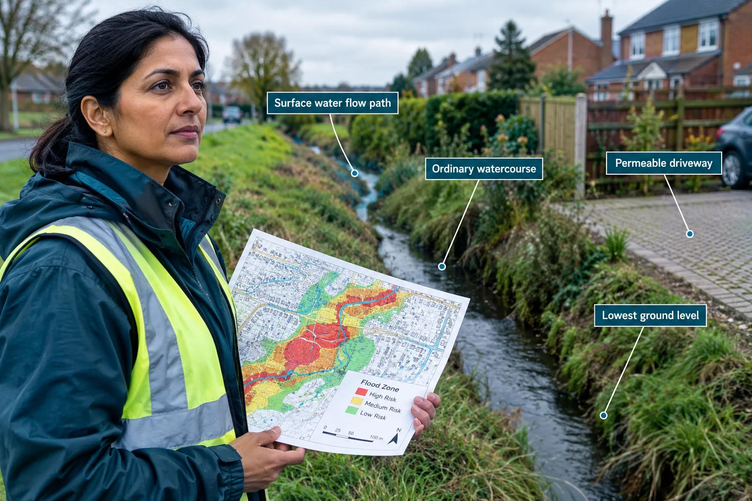
Flood risk is not a single number. RICS practice information published in October 2025 identifies five distinct flood sources that a surveyor must evaluate: fluvial (river), coastal, surface water, groundwater and infrastructure-related flooding from sewer or drainage failure [1][2]. Each source has a different mapped dataset, a different seasonal pattern and a different set of property-level consequences.
Reading Flood Zone Classifications
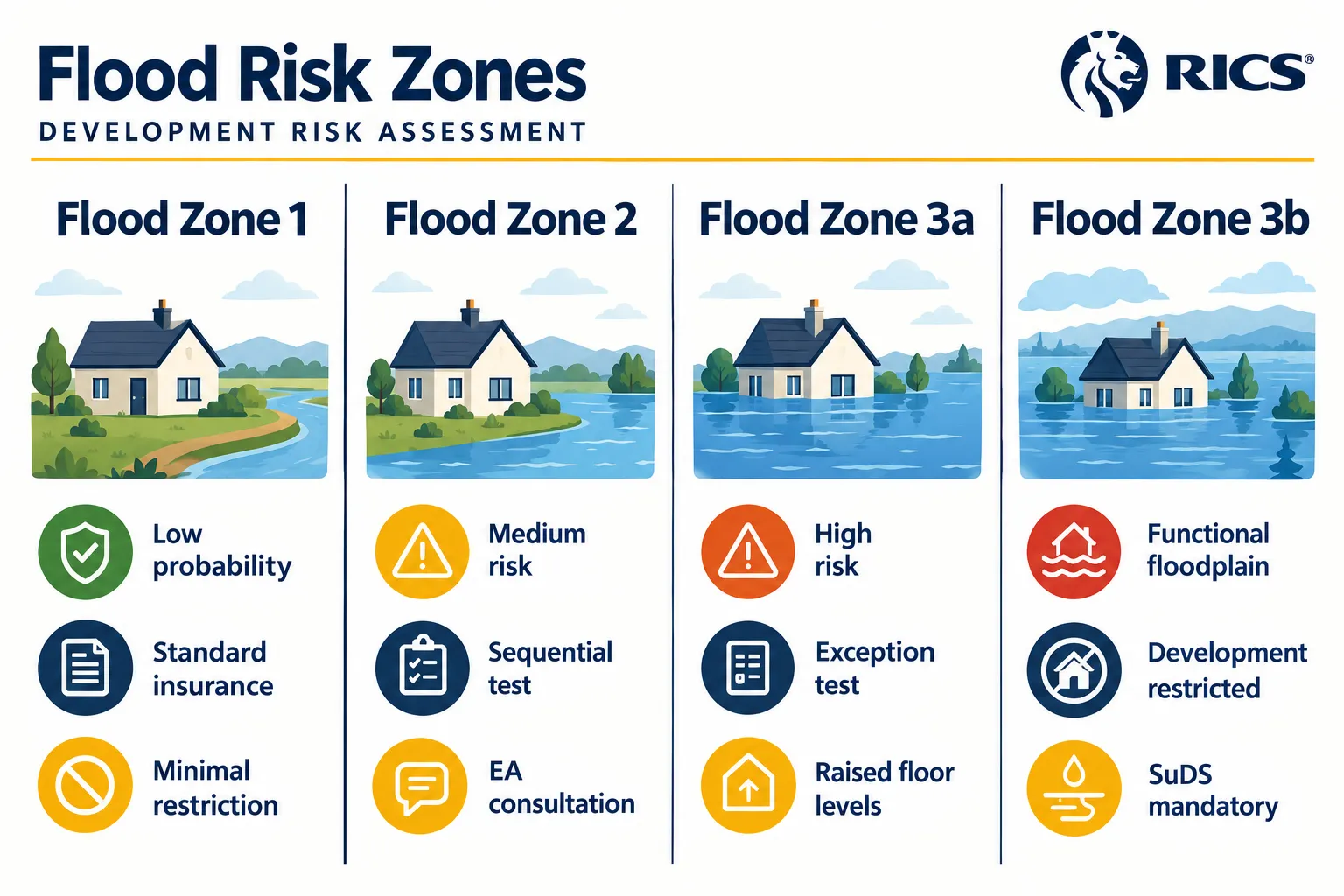
The planning system in England uses a sequential approach to flood risk. Flood Zone 1 carries the lowest probability; Flood Zone 3b, the functional floodplain, is the most constrained. The table below summarises what each zone means in practice.
| Flood Zone | Annual probability | Planning implications | Typical survey action |
|---|---|---|---|
| Zone 1 | Less than 0.1% | Minimal restriction | Note; check surface-water layer |
| Zone 2 | 0.1%,1% | Sequential test applies | FRA recommended; drainage review |
| Zone 3a | Greater than 1% | Sequential and exception tests | Full FRA; raised floor levels; resilience measures |
| Zone 3b | Functional floodplain | Development severely restricted | Development viability assessment; SuDS mandatory |
Flood zone classification affects more than planning. Mortgage lenders, insurers and estate managers all use it when pricing risk [5][7]. A property that sits just inside Zone 3a may carry a materially higher insurance premium than an identical property 50 metres away in Zone 1, and a surveyor advising on market value must account for that differential.
Where Official Maps Fall Short
The NaFRA integrates climate-change impacts and projected future flood depths, which is genuinely useful for long-term development viability assessments. However, RICS consumer guidance warns that government maps do not capture all local groundwater and surface-water risks [4]. A surveyor fills this gap by:
- Measuring finished floor levels and comparing them with modelled flood depths.
- Identifying the lowest openings in a building, air bricks, basement windows, threshold steps, that determine the point at which water enters.
- Tracing overland flow routes from upslope land across the site.
- Checking whether culverted watercourses run beneath or adjacent to the building, which can affect both flood risk and structural stability.
This is precisely the workflow demonstrated in practice by flood-risk assessment projects where surveyors collect first-floor thresholds, lowest openings and typical ground elevations, which then feed into hydraulic modelling and community-scale flood-risk maps [6].
For properties in areas such as Barking or Redbridge, both of which contain land with surface-water and fluvial flood exposure, this site-level elevation data is the difference between a generic map reference and a meaningful risk assessment.
Drainage, Access and Development Risk: The Full Location Picture
Flooding is the most visible location risk, but a thorough desk study and site inspection cover three further categories: drainage capacity, access constraints and development risk from nearby activity.
Drainage Assessment
Drainage assessment covers two questions: how does water leave this site, and does the receiving system have the capacity to accept it?
On-site drainage involves identifying:
- Soakaways, their size, condition and whether ground conditions support infiltration.
- Private drains, their route, fall and connection to the public sewer.
- Surface water disposal, whether run-off discharges to a sewer, a watercourse or an infiltration system, and whether that arrangement has the necessary consent.
Off-site, the surveyor checks whether the public sewer is combined (foul and surface water together) or separate, and whether any drainage conditions attached to planning consents require Sustainable Drainage Systems (SuDS). RICS practice information places SuDS design firmly within the surveyor's advisory scope, particularly for new-build and retrofit projects [1][5].
Poor drainage is also a direct cause of damp. A surveyor who identifies inadequate surface drainage around a building will flag it as a risk factor for rising and penetrating damp, a connection explored further in our article on damp survey costs and what a damp surveyor does in London.
Access Constraints
Access is assessed through a combination of mapping and physical inspection:
- Road classification and width, Ordnance Survey data identifies whether the access road is adopted highway, private road or unmaintained track.
- Rights of way, footpaths, bridleways or public rights of way crossing the site can restrict development and affect privacy.
- Shared drives and easements, the legal basis for access across third-party land, which a surveyor flags for the client's solicitor to investigate in title.
- Flood-affected access routes, a property may sit in Flood Zone 1 yet have its only vehicular access across a road that floods regularly in Flood Zone 3.
This last point is frequently missed by automated searches. A surveyor using mapped flood extents alongside road-level data can identify whether emergency access would be cut off during a flood event, a material consideration for mortgage lenders and insurers alike.
Development Risk from Nearby Activity
Maps reveal what surrounds a property as well as what lies beneath it. A surveyor's desk study will check:
- Nearby planning applications, proposed housing estates, commercial units or infrastructure that could affect drainage, access, noise or views.
- Contaminated land registers, former industrial sites that may affect ground conditions or require remediation before development.
- Tree Preservation Orders, trees protected by TPO that constrain development and, in some cases, contribute to subsidence risk on shrinkable clay soils. This is covered in detail in our article on whether garden trees cause subsidence.
- Conservation areas and listed buildings, designations that restrict permitted development and affect the cost and viability of alterations.
For clients considering development, the surveyor's location analysis feeds directly into a flood-risk assessment (FRA) that the planning authority will require. RICS guidance links flood-risk assessment explicitly to planning, design and construction standards including BS 85500:2025, making mapped flood extents and elevation data central to professional advice on development viability [1][2].
How Survey Reports Communicate Location Risk
RICS home survey standards require surveyors to report systematically on flood risk, drainage and access as part of a Level 2 or Level 3 survey [10]. The difference between a Level 2 and Level 3 survey matters here: a Level 3 building survey will include a more detailed analysis of drainage, access and site-specific flood risk, whereas a Level 2 report flags concerns and recommends specialist investigation.
A well-written survey report will:
- State the flood zone and the source of that information.
- Note any discrepancy between the national map and site-level observations.
- Describe the drainage arrangement and identify any defects or capacity concerns.
- Record access constraints and flag any that require legal investigation.
- Recommend further specialist reports, a formal FRA, a CCTV drain survey or a topographic survey, where the desk study and site inspection reveal elevated risk.
This structured approach means the report is actionable. A buyer can take the surveyor's findings to a solicitor, a mortgage broker or an insurer with a clear statement of the risks identified and the investigations recommended. Our guide on using an RICS survey to negotiate on price explains how location risks identified in a survey can support a price reduction or a request for remediation before exchange.
For properties in areas with known flood exposure, such as Hounslow, which contains land adjacent to the River Thames and its tributaries, a surveyor's ability to read and interpret location data is directly relevant to the advice a buyer receives.
Property Flood Resilience: From Risk Assessment to Practical Measures
Identifying flood risk is only half the task. RICS practice information and insurer guidance both emphasise that surveyors should advise on property flood resilience (PFR) measures once the risk profile is established [1][5][9]. These fall into two categories:
Resistance measures, designed to keep water out:
- Flood doors and barriers at threshold level.
- Air-brick covers and non-return valves on drainage.
- Waterproof renders and tanking to below-ground walls.
Resilience measures, designed to limit damage if water enters:
- Raised electrical sockets and consumer units.
- Solid floors rather than suspended timber.
- Water-resistant insulation and wall finishes.
The surveyor's site measurements, finished floor levels, lowest opening heights, ground gradients, determine which measures are appropriate and at what threshold they activate. This is why RICS urges property owners to seek a specialist flood survey before committing to resilience works: a measure designed for a 150mm flood depth is inadequate if the site survey shows the property is exposed to 400mm inundation [1][9].
FAQ: Surveyors, Maps and Location Risk
Does a standard homebuyer survey include a flood-risk check?
A RICS Level 2 Home Survey will flag the flood zone and note any visible drainage concerns, but it is not a standalone flood-risk assessment. Where the desk study or site inspection raises concerns, the surveyor will recommend a specialist FRA.
Can I rely on a free online flood-map search?
Free searches give a postcode-level flood zone, which is a useful starting point. They do not capture groundwater risk, surface-water accumulation in local low points, drainage capacity or access constraints. A chartered surveyor's assessment draws on multiple datasets and site-level measurements that a postcode search cannot replicate [3][4].
What is a Flood Risk Assessment and when is one required?
An FRA is a technical report assessing the probability, source and consequences of flooding at a specific site. Planning authorities in England require one for most development in Flood Zones 2 and 3, and for sites over one hectare in Flood Zone 1. Surveyors and engineers prepare FRAs using hydraulic modelling, site surveys and mapped flood data.
How does flood zone affect mortgage and insurance?
Lenders apply stricter criteria to properties in Flood Zones 2 and 3, and some will not lend on Zone 3b land without specialist flood-risk mitigation. Insurers use flood-zone data alongside claims history to price buildings insurance; properties in high-risk zones may face higher premiums or excesses [5][7].
What is SuDS and why does it matter for development?
Sustainable Drainage Systems manage surface-water run-off through infiltration, storage or slow release rather than direct discharge to sewers. Planning policy in England requires SuDS for most new developments, and surveyors advising on development viability must assess whether a site's ground conditions and drainage constraints allow SuDS to be designed effectively [1][5].
Does a party wall surveyor consider flood or drainage risk?
A party wall surveyor's primary role under the Party Wall etc. Act 1996 is to resolve disputes about works affecting shared structures. However, drainage works, such as underpinning near a shared drain or excavation close to a watercourse, can have flood and drainage implications that a party wall award should address. See our guide to the Party Wall Act 1996 for more detail.
Conclusion
A property's location risk profile, flooding, drainage, access and nearby development, is assembled from maps and data long before a surveyor opens a gate or lifts a manhole cover. The desk study is where national flood maps, LiDAR terrain models, sewer records and planning data are read together to build a picture that no automated search can replicate.
For buyers, the practical steps are straightforward. Commission a Level 2 or Level 3 RICS survey from a chartered surveyor who will carry out a proper desk study as well as a physical inspection. If the report flags flood, drainage or access concerns, act on the recommendations: instruct a specialist FRA, commission a CCTV drain survey or ask your solicitor to investigate access rights before exchange. Where the surveyor identifies flood risk, ask specifically about property flood resilience measures and what site-level data supports those recommendations.
The cost of a thorough survey and any follow-up investigations is small relative to the financial exposure of buying a property with unresolved location risks. Chartered surveyors who understand how to read and apply maps and location data are the most reliable source of that protection.
References
[1] Flooding And Its Implications For Property Professionals October 2025 – rics.org
[2] Rics Releases New Insight Paper Flooding Property – rics.org
[3] Flooding And Its Implications For Property Professionals – rics.org
[4] Flooding – rics.org
[5] Flooding Risk Cost Property Rics – ww3.rics.org
[6] Flood Risk Assessment – mvr.usace.army.mil
[7] Flood Risk – isurv.com
[9] Flood Guidance And Mitigation Uk Lps – static.aviva.io
[10] Home Survey Standards – rics.org