
A single ransomware attack on a surveying firm's GIS database can freeze an entire infrastructure project, expose client financial data, and trigger regulatory penalties that dwarf the cost of any property transaction. Yet a 2025 industry analysis found that fewer than 40% of small-to-mid-sized surveying practices had a documented incident response plan in place. That gap is closing fast — but not fast enough.
Cybersecurity Essentials for Property Surveyors: Protecting Digital Survey Data in 2026 is no longer a niche IT concern. It sits at the intersection of professional standards, legal compliance, and client trust. As surveying firms migrate boundary records, structural assessments, and geospatial datasets to cloud platforms and AI-assisted tools, the attack surface grows wider with every project.
This article outlines the most pressing digital threats facing property surveyors today, the regulatory landscape shaping data protection obligations, and the practical controls that reduce risk without disrupting fieldwork.
Key Takeaways
- Regulatory bodies including RICS and the GSA have introduced binding cybersecurity and AI governance standards in 2026 that directly affect surveying practices.
- Cloud and AI platforms introduce specific vulnerabilities — misconfigured storage, insecure APIs, and AI model poisoning — that require targeted controls.
- Multi-factor authentication, AES-256 encryption, zero-trust architecture, and role-based access controls form the core technical defence stack for surveying firms.
- Staff training is consistently identified as the single highest-return investment in reducing successful phishing and social engineering attacks.
- Regular risk assessments, cloud configuration audits, and immutable backup solutions are essential for maintaining data integrity across long-running infrastructure projects.
The Threat Landscape Facing Property Surveyors in 2026
Property surveyors handle data that is uniquely attractive to cybercriminals: precise boundary coordinates, structural defect reports, client identity documents, mortgage-linked valuations, and proprietary geospatial datasets. Each of these categories carries financial, legal, or competitive value on the dark web.
Why Surveying Firms Are Targeted
Three factors make surveying practices a growing target:
- High-value data, lower defences. Unlike banks or healthcare providers, many surveying firms operate without dedicated IT security teams, making them softer targets than the data they hold would suggest.
- Complex supply chains. A single project may involve drone operators, GIS subcontractors, local authority portals, and cloud storage providers — each representing a potential entry point.
- Increasing AI adoption. As firms integrate AI tools for automated valuation, defect detection, and report generation, new vectors emerge: model poisoning, adversarial inputs, and insecure API connections to third-party platforms.
The most common attack types reported by property and infrastructure firms in 2025 and early 2026 include:
| Attack Type | Primary Risk to Surveyors |
|---|---|
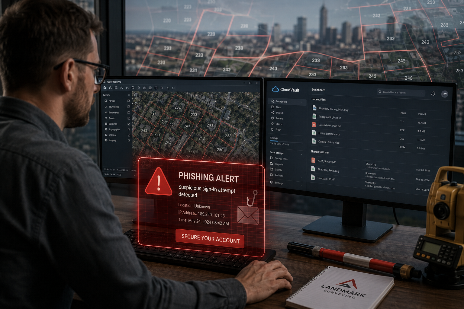
| Phishing and spear-phishing | Credential theft, client data exposure |
| Ransomware | Loss of project files, GIS data, client records |
| Cloud misconfiguration | Inadvertent public exposure of survey reports |
| Insider threats | Unauthorised data exfiltration by staff or contractors |
| API vulnerabilities | Unauthorised access to integrated GIS or valuation platforms |
| Supply chain attacks | Compromise via third-party software or subcontractors |
For firms undertaking monitoring surveys on large infrastructure projects, the stakes are particularly high. A compromised structural monitoring dataset could lead to flawed engineering decisions with serious safety consequences.
The AI Dimension
On 9 March 2026, the Royal Institution of Chartered Surveyors (RICS) implemented the first global professional standard for responsible AI use in surveying. The standard mandates clear policies on data use, AI system governance, and risk documentation [1]. This is a landmark shift: AI governance and cybersecurity are now formally linked within the profession's regulatory framework.
Surveyors using AI-assisted valuation or defect-detection tools must now document how training data is sourced, stored, and protected. An AI system trained on poorly secured client data is both a cybersecurity liability and a compliance failure under the new RICS standard.
Regulatory Standards Shaping Data Protection Obligations
Understanding the regulatory environment is essential before selecting technical controls. In 2026, three major developments are reshaping what surveying firms must do — not just what they should do.
RICS Global AI Standard
The RICS AI standard, effective March 2026, goes beyond AI ethics. It requires firms to maintain governance documentation covering data provenance, model risk, and incident reporting [1]. For chartered surveyors, failure to comply risks disciplinary action and reputational damage. Firms working with clients who rely on RICS property valuations or RICS building surveys need to ensure their AI tools meet these governance requirements before deploying them in client-facing workflows.
ALTA/NSPS Updated Standards
Effective 23 February 2026, the American Land Title Association (ALTA) and the National Society of Professional Surveyors (NSPS) revised their Minimum Standard Detail Requirements. The updates emphasise enhanced precision, transparency, and uniformity in how surveyors manage and document digital data [2]. While these standards originate in the US, they influence international practice norms and are increasingly referenced in cross-border property transactions.
GSA Cybersecurity Requirements for Government Contractors
In March 2026, the General Services Administration (GSA) released an updated IT Security Procedural Guide imposing strict cybersecurity obligations on government contractors. Requirements include implementing NIST SP 800-171 Rev 3 standards, reporting cyber incidents within one hour, and undergoing independent security assessments [3]. Surveying firms engaged in public sector infrastructure projects — from highway land acquisition to flood defence mapping — fall within scope of these obligations.
"Cybersecurity compliance is no longer optional for surveyors working on public contracts. The one-hour incident reporting window alone demands that firms have automated detection and response capabilities already in place."
Core Cybersecurity Controls for Protecting Digital Survey Data
Cybersecurity Essentials for Property Surveyors: Protecting Digital Survey Data in 2026 demands a layered approach. No single control is sufficient. The following framework addresses the most critical risk areas identified across the research base.
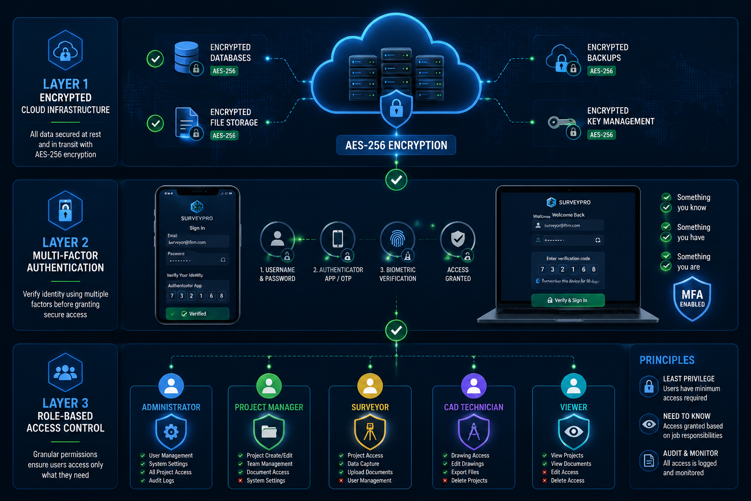
Multi-Factor Authentication
Multi-factor authentication (MFA) should be mandatory across all critical applications: GIS platforms, cloud storage, client management systems, email, and remote access tools [4]. MFA reduces the effectiveness of stolen credentials — the most common initial access method in surveying-sector breaches — by requiring a second verification step that attackers typically cannot replicate.
Implementation priorities:
- Enable MFA on all cloud-hosted survey data repositories
- Require MFA for remote desktop and VPN connections
- Use authenticator apps rather than SMS codes where possible, as SMS is vulnerable to SIM-swapping attacks
Encryption at Rest and in Transit
Sensitive survey data — boundary coordinates, structural defect findings, client identity documents — must be encrypted both when stored and when transmitted [4]. AES-256 encryption is the current standard for data at rest. TLS 1.3 or higher should be enforced for all data in transit, including API calls between GIS platforms and cloud storage.
Firms that share survey reports with clients via email or file transfer platforms should use encrypted delivery methods rather than unprotected attachments. This is especially relevant for practices producing homebuyers reports or detailed structural assessments containing sensitive property information.
Zero-Trust Security Architecture
Zero-trust operates on a simple principle: no user, device, or system is trusted by default, even inside the network perimeter. Every access request is verified continuously [4]. For surveying firms, this means:
- Verifying device health before granting access to survey data
- Applying least-privilege access — users see only what their role requires
- Segmenting networks so that a breach in one area cannot spread laterally to GIS or financial systems
Role-Based Access Controls
Role-based access control (RBAC) ensures that staff members can only access data relevant to their specific function [5]. A field surveyor conducting a building survey does not need access to client billing records. An administrator processing invoices does not need access to raw GIS datasets.
Recommended RBAC tiers for surveying firms:
| Role | Data Access Level |
|---|---|
| Field Surveyor | Active project files, GIS data for assigned sites |
| Senior Surveyor / Partner | All project files, client records, financial summaries |
| IT / Systems Administrator | System configuration, access logs, backup management |
| Administrative Staff | Client contact details, invoicing, scheduling |
| External Contractors | Scoped project data only, time-limited access |
Cloud Configuration Audits
Cloud misconfiguration is one of the most common causes of data exposure in the property sector. A storage bucket set to public access, an overly permissive API key, or an unpatched cloud application can expose thousands of survey records without any active attack [4].
Firms should conduct cloud configuration audits at least quarterly, using automated scanning tools to identify:
- Publicly accessible storage containers
- Unused or over-privileged service accounts
- Unencrypted data stores
- Outdated software versions on cloud-hosted applications
Backup Integrity and Ransomware Resilience
Ransomware attacks targeting surveying firms typically aim to encrypt both live data and accessible backups simultaneously. Protecting backup repositories requires immutable storage — backups that cannot be altered or deleted for a defined retention period — and air-gapped configurations that keep backup copies isolated from the main network [4].
A 3-2-1 backup strategy remains the baseline: three copies of data, on two different media types, with one copy stored offsite or in an isolated cloud environment.
Security Information and Event Management (SIEM)
SIEM systems aggregate log data from across the network — firewalls, endpoints, cloud platforms, GIS servers — and apply rules and machine learning to detect anomalous behaviour in real time [4]. For surveying firms handling government contracts, SIEM is increasingly a compliance requirement rather than an optional enhancement. The GSA's one-hour incident reporting window [3] is practically impossible to meet without automated detection already in place.
Staff Training and Phishing Awareness
Technology controls fail when staff are manipulated into bypassing them. Phishing remains the most common initial attack vector across all sectors, and surveying firms are not exempt [6]. Effective training programmes include:
- Simulated phishing exercises conducted at least quarterly
- Clear protocols for reporting suspicious emails without fear of blame
- Training on password hygiene and the use of password managers
- Awareness of social engineering tactics targeting project handover periods, when large file transfers and new contacts are routine
Practical Steps for Surveying Firms: Building a Cybersecurity Culture
Cybersecurity Essentials for Property Surveyors: Protecting Digital Survey Data in 2026 is ultimately a people and process challenge as much as a technical one. Firms that treat security as an IT department issue rather than a firm-wide responsibility consistently underperform in incident response.
Conduct a Formal Risk Assessment
A structured risk assessment identifies vulnerabilities in software, email systems, physical devices, and third-party integrations before attackers do [6]. For surveying practices, this should include:
- Mapping all data flows: where survey data is created, stored, transmitted, and archived
- Identifying all third-party platforms with access to client or project data
- Assessing the cybersecurity posture of key subcontractors and technology vendors
- Documenting findings and assigning remediation owners with deadlines
Develop an Incident Response Plan
An incident response plan defines exactly what happens when a breach occurs: who is notified, what systems are isolated, how clients are informed, and how regulatory reporting obligations are met. Given the GSA's one-hour reporting window [3] and RICS's new governance requirements [1], having this plan documented and tested is non-negotiable for firms with public sector or RICS-regulated work.
Align with Professional Standards
Surveyors choosing to work with RICS-accredited surveyors benefit from a professional framework that now explicitly incorporates AI and data governance. Firms should review their existing data handling policies against the March 2026 RICS AI standard and the updated ALTA/NSPS requirements to identify compliance gaps.
For practices operating across multiple locations — from Westminster to Richmond — consistent cybersecurity policies applied across all offices are essential. A breach at a satellite office that uses weaker controls can compromise the entire firm's data estate.
Vendor Due Diligence
Every software platform, cloud provider, and subcontractor with access to survey data represents a potential risk. Firms should require vendors to demonstrate:
- SOC 2 Type II certification or equivalent
- Data processing agreements aligned with UK GDPR
- Clear breach notification procedures
- Regular independent security assessments

Conclusion
The convergence of AI adoption, cloud migration, and tightening regulation has made cybersecurity a core professional competency for property surveyors in 2026. The RICS AI standard, updated ALTA/NSPS requirements, and GSA contractor obligations collectively signal that data protection is now embedded in professional accountability — not delegated to IT.
Actionable next steps for surveying firms:
- Complete a formal risk assessment covering all data flows, third-party integrations, and physical devices within the next 90 days.
- Implement MFA across all cloud platforms and remote access tools immediately — this single control eliminates the majority of credential-based attacks.
- Audit cloud storage configurations quarterly and remediate any publicly accessible or unencrypted data stores.
- Establish role-based access controls aligned to the tiers outlined above, and review them whenever staff roles change.
- Document an incident response plan that meets the GSA's one-hour reporting requirement and RICS governance obligations.
- Schedule quarterly phishing simulation exercises and make cybersecurity awareness training a mandatory part of onboarding.
- Review AI tool governance documentation against the March 2026 RICS standard before deploying any AI-assisted valuation or reporting tools.
Firms that build these controls into standard operating procedure — rather than treating them as one-off projects — will be better positioned to win public sector contracts, retain client trust, and avoid the regulatory and reputational costs of a preventable breach.
References
[1] Rics Launches Landmark Global Standard On Responsible Use Of Ai In Surveying – https://www.rics.org/news-insights/rics-launches-landmark-global-standard-on-responsible-use-of-ai-in-surveying?utm_source=openai
[2] Updated Alta Nsps Land Title Survey Standards Take Effect Feb 23 – https://www.mcguirewoods.com/client-resources/alerts/2026/2/updated-alta-nsps-land-title-survey-standards-take-effect-feb-23/?utm_source=openai
[3] New Gsa Guide Imposes Strict Cybersecurity Obligations On Government Contractors – https://www.skadden.com/insights/publications/2026/03/new-gsa-guide-imposes-strict-cybersecurity-obligations-on-government-contractors?utm_source=openai
[4] Cybersecurity Essentials For Property Surveyors Protecting Gis And Cloud Based Data In 2026 – https://kingstonsurveyors.com/cybersecurity-essentials-for-property-surveyors-protecting-gis-and-cloud-based-data-in-2026/?utm_source=openai
[5] Security – https://propertyinspect.com/security/?utm_source=openai
[6] Cybersecurity For Property Managers Protecting Data In A Connected World – https://www.ross-companies.com/blog/2025/10/18/cybersecurity-for-property-managers-protecting-data-in-a-connected-world/?utm_source=openai