Fewer than 30% of surveying firms had fully cloud-connected field-to-office workflows just five years ago. By 2026, that figure has shifted dramatically, and firms still relying on siloed desktop software and manual data transfers are losing ground to competitors who deliver faster, more accurate results. Digital Transformation in Surveying 2026: Cloud Platforms, Interoperable Tools, and Workforce Strategies is no longer a future-facing aspiration — it is the operational baseline for firms that want to remain relevant, profitable, and able to attract skilled talent in a tightening labour market.
This article examines six key trends shaping the surveying sector right now, drawing on insights from industry analysts and technology leaders. It also provides practical steps firms can take to integrate cloud platforms, build interoperable tool stacks, and develop the workforce capabilities needed to sustain long-term competitive advantage.
Key Takeaways
- Cloud platforms now enable real-time data sharing between field surveyors and office teams, cutting project delays and rework significantly.
- Interoperability between hardware and software tools is the defining IT strategy challenge for architecture, engineering, and construction (AEC) firms in 2026.
- Reality capture technology — including laser scanning and photogrammetry — has become accessible to firms of all sizes, not just large enterprises.
- Common Data Environments (CDEs) consolidate project data from multiple disciplines into a single secure hub, reducing information loss across project stages.
- Workforce shortages in surveying are being partially offset by digital tools that automate repetitive tasks and enable remote collaboration.
Six Trends Redefining Digital Transformation in Surveying 2026
Trend 1: Reality Capture Moves from Specialist to Standard
Reality capture — encompassing laser scanning, photogrammetry, and drone-based data collection — has crossed a critical threshold. Equipment costs have fallen, software has become more intuitive, and the resulting data quality has improved to the point where these tools are now practical for small and mid-sized surveying practices, not just large engineering firms [1].
The practical impact is significant. A surveyor who previously spent days manually measuring and sketching a complex structure can now capture the same data in hours using a handheld scanner or drone. The resulting point cloud is richer, more accurate, and directly importable into modelling software. For clients, this translates into faster project delivery and fewer costly errors on site.
Firms investing in reality capture are also seeing safety improvements. Surveyors can capture data in hazardous or difficult-to-access areas without putting personnel at unnecessary risk — a benefit that resonates strongly with health and safety obligations across the UK construction sector. For those involved in construction surveying, these tools are rapidly becoming non-negotiable.
Trend 2: Cloud Platforms Enable Real-Time Field-to-Office Collaboration
The shift to cloud-based project management is arguably the single most impactful operational change in surveying over the past three years. Cloud platforms allow field surveyors and office-based project managers to access, update, and share data simultaneously, eliminating the version-control problems and communication delays that have historically plagued large surveying projects [2].
"Cloud adoption reshapes roles and responsibilities, requiring clear accountability models to avoid fragmentation across IT, operations, vendors, and regulators." [5]
This is particularly relevant for firms managing multiple concurrent projects across different locations. A surveyor conducting a property inspection in one part of London can upload findings directly to a shared project environment, where a senior chartered surveyor in the office can review and annotate them in real time. The result is faster decision-making, fewer site revisits, and more consistent report quality.
Key capabilities to look for in a cloud surveying platform include:
- Offline field access with automatic sync when connectivity is restored
- Role-based permissions to protect sensitive client data
- Integration APIs that connect to existing CAD, GIS, and BIM software
- Audit trails for regulatory compliance and dispute resolution
- Scalable storage that grows with project data volumes
Trend 3: Common Data Environments Consolidate Project Intelligence
A Common Data Environment (CDE) is a shared digital space where all project-related information — from initial survey data through design, construction, and asset management — is stored, managed, and accessed by all authorised parties [1]. In 2026, CDEs have evolved from a best-practice recommendation into a practical necessity for any project involving multiple disciplines or stakeholders.
The core value of a CDE is that it eliminates the information silos that cause costly rework. When a structural engineer, a quantity surveyor, and a building services consultant all work from the same verified dataset, design clashes are caught earlier, and the risk of contradictory information reaching site is dramatically reduced.
For firms producing condition survey reports or managing complex building assessments, CDEs provide a structured way to link survey findings to specific asset records, making it easier to track remediation work and demonstrate compliance over time.
Practical steps for CDE adoption:
| Step | Action | Outcome |
|---|---|---|
| 1 | Audit existing data storage and workflows | Identify duplication and gaps |
| 2 | Select a CDE platform aligned with project types | Ensure compatibility with client systems |
| 3 | Define naming conventions and folder structures | Reduce search time and version confusion |
| 4 | Train all project stakeholders on access protocols | Improve adoption and data quality |
| 5 | Establish a data quality review process | Maintain integrity of shared information |
Trend 4: Digital Twins Evolve into Living Asset Records
Digital twins — detailed virtual representations of physical assets — have matured considerably. Where they were once static models handed over at project completion, they are now dynamic, continuously updated records that reflect the current state of a building or infrastructure asset [3].
For surveyors, this evolution creates new service opportunities. Firms that can deliver and maintain a digital twin as part of their service offering are providing clients with something far more valuable than a traditional survey report: an ongoing decision-support tool that can inform maintenance planning, energy performance assessments, and future renovation work.
The connection between digital twins and AI-driven analytics is particularly powerful. AI can be layered over integrated project data to predict maintenance risks, identify structural issues before they become critical, and analyse how a building is performing against its design intent [3]. This is directly relevant to the kind of detailed assessments covered in a full structural survey, where long-term asset condition is a central concern.
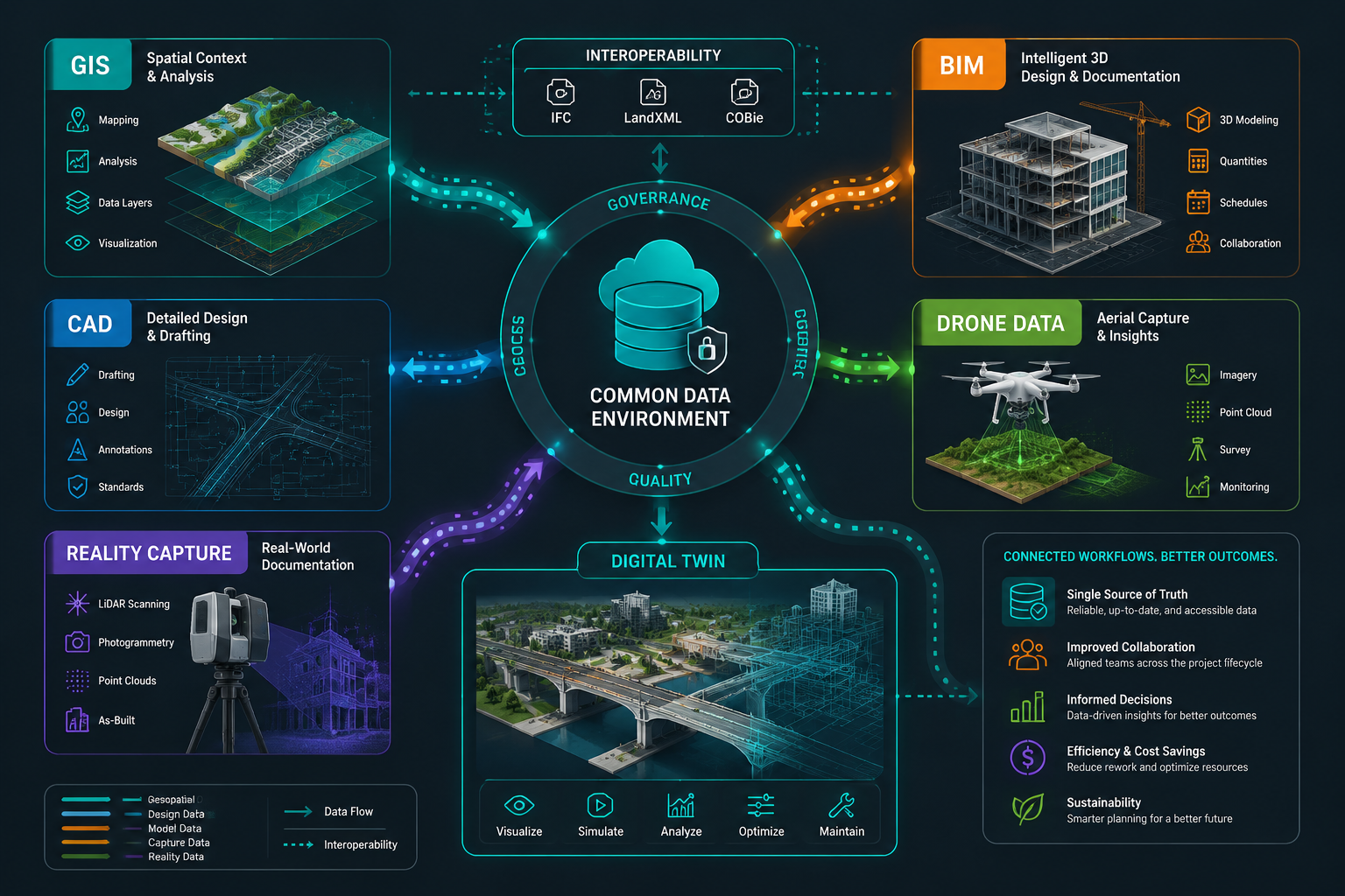
Interoperability as the Central IT Strategy for 2026
Why Disconnected Tool Stacks Are a Competitive Liability
Digital Transformation in Surveying 2026: Cloud Platforms, Interoperable Tools, and Workforce Strategies cannot be achieved with a collection of disconnected software applications that do not communicate with each other. Yet this remains the reality for a significant proportion of surveying firms, where data collected in the field must be manually re-entered into office systems, introducing delays, errors, and inefficiencies at every handover point.
Construction technology vendors are accelerating efforts to enhance cross-platform data sharing, and firms that select tools based on interoperability — rather than individual feature sets alone — are gaining a measurable competitive advantage [3]. The ability to move data seamlessly from a drone capture platform into a BIM environment, and from there into a client-facing reporting system, without manual intervention, is now a realistic expectation rather than an aspirational goal.
Geographic information systems (GIS) are a particularly important integration point. Surveyors working with geographic information systems need their GIS data to flow cleanly into project management platforms, asset registers, and client reporting tools. Firms that have achieved this level of integration report significant reductions in project turnaround times and improved client satisfaction scores.
Building an Interoperable Tool Stack: A Practical Framework
Selecting and integrating tools effectively requires a structured approach. The following framework helps firms move from fragmented systems to a coherent, interoperable technology ecosystem:
Step 1 — Map current data flows. Document where data is created, how it moves between systems, and where manual re-entry currently occurs. This reveals the highest-value integration opportunities.
Step 2 — Prioritise open standards. Favour tools that support open data formats such as IFC, LandXML, and GeoJSON over proprietary formats that lock data into a single vendor's ecosystem.
Step 3 — Evaluate vendor integration roadmaps. Ask software vendors directly about their integration partnerships and API development plans. A vendor with a strong interoperability roadmap is a safer long-term investment.
Step 4 — Pilot before committing. Run a controlled pilot project using the proposed integrated stack before rolling it out firm-wide. Measure time savings, error rates, and user adoption.
Step 5 — Assign a data governance lead. Interoperable systems generate large volumes of data. Someone needs to own data quality, naming conventions, and access controls across the entire ecosystem.
AI Integration: From Automation to Predictive Intelligence
Artificial intelligence is no longer a peripheral feature in surveying software — it is increasingly embedded in core workflows. AI tools are automating data processing tasks that previously required hours of manual effort, such as classifying point cloud data, identifying structural anomalies in imagery, and generating draft condition reports from field notes [4].
More significantly, AI-driven analytics are beginning to provide predictive capabilities. By analysing patterns across large datasets — including historical survey findings, maintenance records, and environmental data — AI can flag properties or assets that are likely to develop specific problems before those problems become visible [3]. For firms offering building surveys, this kind of predictive insight represents a genuine value-add that differentiates their service from competitors still producing purely descriptive reports.
Data quality is the critical dependency here. AI systems are only as reliable as the data they are trained on and fed in operation [5]. Firms investing in AI tools must simultaneously invest in data governance processes that ensure their field data is accurate, consistently structured, and properly labelled.
Workforce Strategies for the Digital Surveying Firm
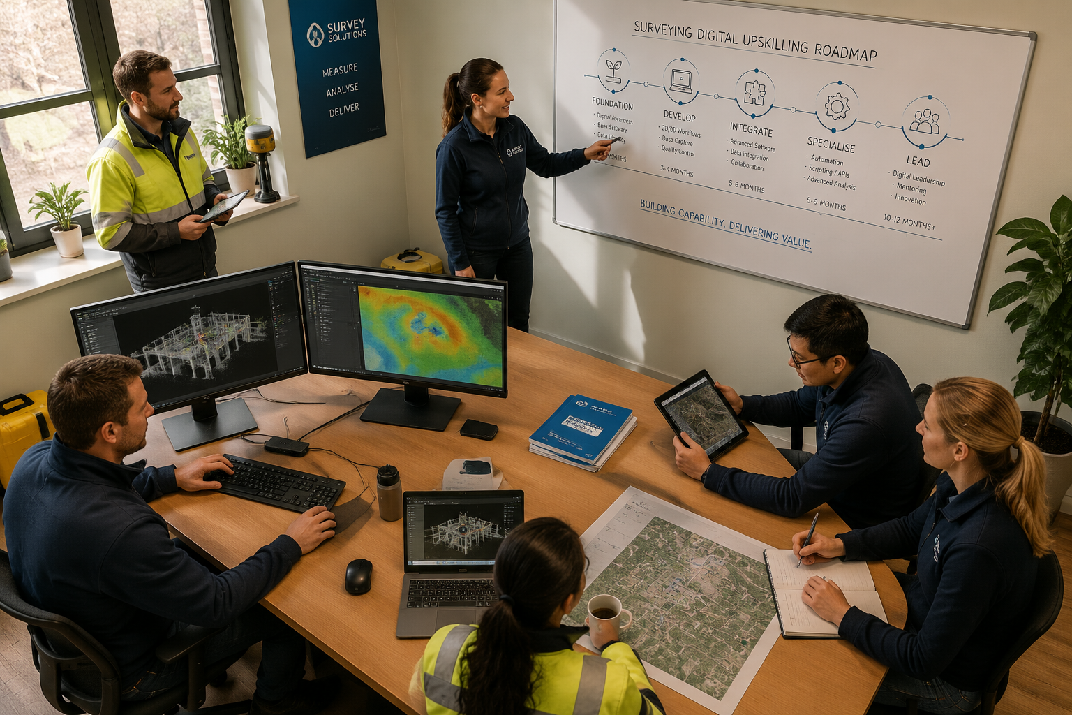
Addressing the Skills Gap Through Targeted Upskilling
Digital Transformation in Surveying 2026: Cloud Platforms, Interoperable Tools, and Workforce Strategies cannot succeed without addressing the human side of the equation. The surveying sector is experiencing well-documented workforce shortages, with demand for qualified surveyors outpacing supply in most UK markets [2]. Digital tools are helping to bridge this gap — but only if the existing workforce has the skills to use them effectively.
The skills gap in surveying is not simply about knowing how to operate new software. It encompasses data literacy, an understanding of how digital systems connect, and the ability to interpret AI-generated outputs critically rather than accepting them uncritically. These are capabilities that require structured development, not just occasional training sessions.
Effective upskilling programmes share several characteristics:
- They are role-specific, addressing the actual tools and workflows each team member uses daily.
- They include practical, hands-on components rather than relying solely on video tutorials or classroom instruction.
- They are continuous, with regular refreshers as tools evolve and new features are introduced.
- They are linked to career progression, giving employees a clear incentive to develop digital competencies.
For firms looking to find the best local surveyor or build their own team, digital competency is increasingly a key differentiator in both hiring and client-facing credibility.
Remote Collaboration and Flexible Working Models
Cloud platforms and interoperable tools have made it practical for surveying firms to operate with more flexible working arrangements. Senior surveyors can review field data, annotate reports, and communicate with clients from any location with an internet connection. This flexibility has two important strategic benefits.
First, it expands the talent pool. Firms are no longer limited to hiring surveyors who live within commuting distance of a single office. Second, it improves retention among experienced professionals who value flexibility — a significant consideration given the cost and disruption of losing a senior chartered surveyor.
However, remote collaboration requires deliberate management. Clear accountability structures — defining who is responsible for what at each stage of a project — are essential to prevent tasks from falling through the gaps when teams are not physically co-located [5]. Firms that have formalised their remote workflows using documented processes and cloud-based task management tools consistently report better outcomes than those relying on informal arrangements.
Attracting the Next Generation of Surveyors
The surveying profession has historically struggled to attract younger entrants who associate the sector with outdated technology and limited career development. The digital transformation underway in 2026 provides a compelling counter-narrative. Firms that can demonstrate they are using cutting-edge technology — drone surveys, AI-assisted analysis, digital twin creation — are finding it significantly easier to recruit graduates and career changers.
This is reinforced by the growing recognition that surveying offers diverse career pathways. A graduate joining a digitally advanced firm today might find themselves working on RICS property valuations, managing GIS data integration, or developing AI-assisted inspection workflows — a breadth of opportunity that was not available to the previous generation of surveyors.
Conclusion
The convergence of reality capture, cloud platforms, common data environments, digital twins, AI integration, and workforce development is reshaping what it means to be a surveying firm in 2026. Firms that treat these trends as isolated technology purchases will see limited returns. Those that approach them as interconnected components of a coherent digital strategy will find themselves better positioned to deliver higher-quality work, attract stronger talent, and build more resilient businesses.
Actionable next steps for surveying firms:
- Conduct a technology audit to identify where data handovers are still manual and where integration opportunities exist.
- Evaluate cloud platform options against an interoperability checklist, not just a feature list.
- Invest in a CDE that aligns with the types of projects the firm handles most frequently.
- Develop a structured digital upskilling programme tied to specific role requirements and career progression.
- Pilot one AI-assisted workflow — such as automated report drafting or anomaly detection in imagery — and measure the time savings before scaling.
- Review accountability structures to ensure remote and hybrid working arrangements have clear ownership at every project stage.
The firms that will define the surveying sector in the next decade are not necessarily the largest — they are the ones making deliberate, well-integrated digital investments today.
References
[1] Doubling Down On Digital – https://amerisurv.com/2026/02/01/doubling-down-on-digital/?utm_source=openai
[2] Workforce Shortages In Surveying Digital Tools Bridging The Labor Gap In 2026 Projects – https://wimbledonsurveyors.com/workforce-shortages-in-surveying-digital-tools-bridging-the-labor-gap-in-2026-projects/?utm_source=openai
[3] Why Interoperability Will Define Aec It Strategy In 2026 – https://www.lyon.tech/news/why-interoperability-will-define-aec-it-strategy-in-2026?utm_source=openai
[4] Digital Trends Operations Survey – https://www.pwc.com/us/en/services/consulting/business-transformation/library/digital-trends-operations-survey.html?utm_source=openai
[5] 8 Digital Transformation Trends Redefining The Utility Market In 2026 – https://www.trccompanies.com/insights/8-digital-transformation-trends-redefining-the-utility-market-in-2026/?utm_source=openai