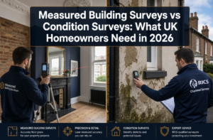
A single millimetre of measurement error in a boundary dispute can cost a property owner tens of thousands of pounds in legal fees. That stark reality is driving a rapid shift toward LiDAR and 3D laser scanning: advanced techniques for precise property surveys — technologies that now deliver sub-centimetre accuracy at speeds no traditional tape measure or theodolite can match.
In 2026, the convergence of GNSS RTK positioning, UAV photogrammetry, and real-time point cloud processing has fundamentally changed what surveyors can deliver to clients. Whether the project involves a Victorian terrace in Richmond or a large commercial development in East London, these tools are redefining the standard of evidence-based surveying.
This article unpacks how these technologies work, how they compare, and how they are being applied in real construction monitoring scenarios — with practical guidance for property owners, developers, and chartered surveyors alike.
Key Takeaways 📌
- LiDAR and terrestrial laser scanning can capture millions of data points per second, producing 3D models accurate to ±2–5 mm.
- GNSS RTK provides real-time centimetre-level geospatial positioning, anchoring scan data to national coordinate systems.
- UAV photogrammetry dramatically reduces survey time on large or complex sites, with 2026 benchmarks showing 60–80% time savings versus ground-only methods.
- Real-time point cloud processing enables on-site decision-making, reducing costly return visits and survey delays.
- These technologies complement — rather than replace — the expertise of a qualified chartered surveyor, particularly for regulated RICS surveys.
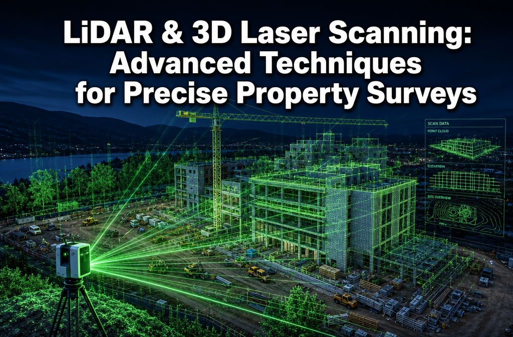
How LiDAR and 3D Laser Scanning Work in Property Surveys
The Physics Behind the Point Cloud
LiDAR (Light Detection and Ranging) works by firing rapid pulses of laser light at a surface and measuring the time it takes for each pulse to return. Multiply that time by the speed of light, divide by two, and you have a precise distance. Repeat this millions of times per second across a rotating mirror system, and the result is a dense 3D point cloud — a digital replica of the physical environment.
Modern terrestrial laser scanners (TLS) used in property surveys typically achieve:
| Specification | Entry-Level TLS | High-End TLS (2026) |
|---|---|---|
| Scan speed | 500,000 pts/sec | 2,000,000+ pts/sec |
| Range accuracy | ±6 mm | ±1–2 mm |
| Maximum range | 80 m | 350 m |
| Field of view | 270° × 360° | 360° × 360° |
| Data format output | .LAS, .E57 | .LAS, .E57, .RCP |
These numbers matter enormously in property surveying. When assessing structural movement, identifying subsidence, or preparing a schedule of condition ahead of a party wall agreement, millimetre-level accuracy is not a luxury — it is a professional requirement.
GNSS RTK: Anchoring Scan Data to the Real World
A point cloud on its own is geometrically precise but spatially orphaned. GNSS RTK (Real-Time Kinematic) positioning solves this by providing a real-time corrected satellite signal, typically achieving ±10–20 mm horizontal accuracy and ±20–30 mm vertical accuracy in open-sky conditions.
In a typical workflow:
- 🛰️ A base station is established at a known control point.
- A rover receiver moves around the site, collecting corrected positions.
- Scan data is georeferenced to the national coordinate grid (e.g., OSGB36 in the UK).
- Multiple scan positions are registered together using both target-based and cloud-to-cloud algorithms.
This integration means that scan data from a property in Hammersmith can be directly compared against Ordnance Survey mapping, planning drawings, or historical survey records — a critical capability when resolving boundary disputes.
💡 Pull Quote: "GNSS RTK doesn't just locate where you are — it locks your entire 3D dataset into a legally defensible spatial framework."
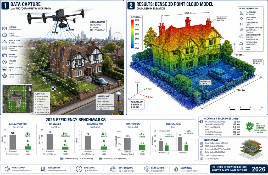
UAV Photogrammetry: Speed Meets Scale
While terrestrial LiDAR excels at close-range, high-detail capture, UAV (drone) photogrammetry fills the gap for large sites, rooftops, and areas inaccessible to ground-based equipment.
Photogrammetry works differently from LiDAR: overlapping aerial photographs are processed using Structure from Motion (SfM) algorithms to generate a dense point cloud and textured 3D mesh. The accuracy of UAV photogrammetry depends heavily on:
- Ground Sampling Distance (GSD) — typically 1–3 cm/pixel at survey altitudes
- Ground Control Points (GCPs) — GNSS-surveyed markers that georeference the model
- Image overlap — typically 80% forward, 70% side overlap for survey-grade output
2026 efficiency benchmarks from UK construction projects show that a UAV photogrammetry survey of a 1-hectare site can be completed in under 45 minutes of flight time, with processed outputs delivered within 2–4 hours using cloud-based photogrammetry platforms. Comparable ground-based surveys of the same area historically took 2–3 days.
Advanced Applications: Construction Monitoring and Structural Assessment
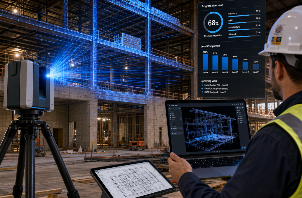
Real-Time Point Cloud Processing for Construction Projects
One of the most transformative developments in 2026 is real-time or near-real-time point cloud processing. Previously, raw scan data had to be taken back to the office for processing — a workflow that could introduce delays of days or even weeks before actionable information reached site teams.
Modern edge-computing solutions now allow:
- On-site registration of multiple scan positions in under 10 minutes
- Automated clash detection comparing as-built conditions against BIM models
- Progress monitoring dashboards updated daily or even hourly on large projects
This capability is particularly valuable in construction monitoring, where deviations from design intent must be caught early. A 2026 case study from a mixed-use development in East London demonstrated that real-time LiDAR monitoring detected a 14 mm wall lean — well within tolerance for correction — that would have been missed until structural finishing had begun, potentially requiring costly demolition and rebuild.
For those involved in construction surveying projects, integrating real-time scan data with project management software has become a recognised best practice.
Deformation Monitoring and Subsidence Detection
LiDAR's ability to capture the same scene at multiple time intervals — known as change detection or deformation monitoring — makes it invaluable for:
- 🏚️ Tracking subsidence in properties near tunnelling or excavation works
- 🏗️ Monitoring retaining wall movement during basement construction
- 🌿 Detecting tree root damage to foundations over time
By comparing point clouds captured weeks or months apart, surveyors can identify movement as small as 3–5 mm — far below the threshold detectable by visual inspection alone.
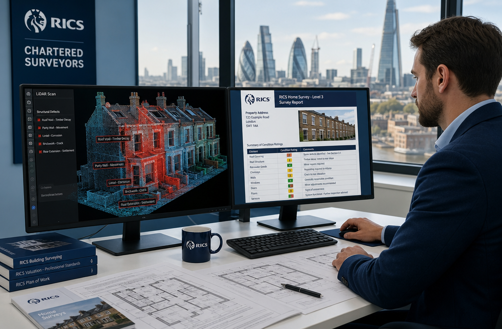
This level of precision is directly relevant to building surveys on older properties, where subtle structural movement can indicate serious underlying issues. A Level 3 building survey on a Victorian terrace, for example, can now be supported by LiDAR-derived crack mapping and deflection analysis — elevating the quality of evidence available to the surveyor.
Heritage and Listed Building Recording
The UK's stock of listed buildings presents unique surveying challenges. Traditional measurement methods risk damaging fragile surfaces, while the geometric complexity of ornate facades defies simple tape-measure documentation.
LiDAR and 3D laser scanning offer a non-contact, non-destructive recording method that captures:
- Intricate mouldings and decorative stonework at sub-millimetre resolution
- Structural deformation invisible to the naked eye
- A permanent as-built archive for future conservation works
Several London boroughs — including Richmond and Camden — now recommend or require LiDAR documentation as part of planning applications for works to Grade I and Grade II listed properties.
Integrating LiDAR Data with RICS Surveys and Professional Practice
Where Technology Meets Professional Judgement
It is important to be clear: LiDAR and 3D laser scanning are tools, not surveyors. The data they produce requires expert interpretation. A point cloud showing a crack pattern in a brick wall does not automatically diagnose the cause — that requires the professional judgement of a qualified chartered surveyor who understands soil mechanics, building pathology, and structural behaviour.
This is why the most effective implementations of these technologies occur when scan data is integrated into the existing RICS survey framework, rather than presented as a standalone product. Understanding what a surveyor does — and the professional standards they operate under — helps clients appreciate why human expertise remains central even as technology advances.
Practical Workflow: From Scan to Survey Report
A typical integrated workflow for a residential property survey in 2026 might look like this:
Stage 1 — Site Mobilisation
- GNSS RTK base station established
- Terrestrial laser scanner positioned at 4–8 stations around the property
- UAV flight conducted for roof and external envelope capture (where permitted)
Stage 2 — Data Processing
- Point clouds registered and georeferenced
- Automated feature extraction (walls, floors, openings)
- Change detection run against any historical scan data
Stage 3 — Surveyor Analysis
- Defects identified and annotated within the point cloud viewer
- Measurements extracted for floor plans, sections, and elevations
- Findings integrated into the RICS survey report
Stage 4 — Report Delivery
- Standard RICS report supplemented with 3D model viewer link
- Annotated point cloud screenshots included as evidence
- Dimensional accuracy stated in the report methodology section
For clients considering which survey level is appropriate, it is worth reviewing how to choose between a Level 2 and Level 3 survey — LiDAR integration is most commonly associated with Level 3 (Building Survey) commissions, though it is increasingly being applied to complex Level 2 instructions as well.
Cost-Benefit Considerations in 2026
The cost of LiDAR surveys has fallen significantly. In 2026, a terrestrial laser scan of a standard residential property typically adds £300–£800 to the base survey cost, depending on property size and complexity. For commercial properties or construction monitoring contracts, costs scale with site area and frequency of capture.
Against this, the risk mitigation value is considerable:
| Risk Mitigated | Potential Cost Without LiDAR |
|---|---|
| Missed subsidence | £15,000–£80,000+ in remediation |
| Boundary encroachment | £5,000–£50,000 in legal costs |
| Structural defect undisclosed | £10,000–£100,000+ in repairs |
| Construction deviation | £20,000–£200,000+ in rework |
For buyers of higher-value properties, or anyone involved in a construction project, the return on investment is straightforward. Clients who have used an RICS survey to negotiate a price reduction will recognise that precise, documented evidence is the most powerful negotiating tool available.
Addressing Common Misconceptions
Several myths about property surveys extend into the technology space. The most common include:
- ❌ "LiDAR replaces the need for a surveyor" — False. It enhances the surveyor's capability but cannot replace professional judgement.
- ❌ "Drone surveys are always legal and unrestricted" — False. UK CAA regulations require operators to hold appropriate permissions, particularly near urban areas and controlled airspace.
- ❌ "Point cloud accuracy is always sub-millimetre" — False. Accuracy depends on scanner specification, environmental conditions, and registration quality.
- ❌ "All surveyors offer LiDAR services" — False. Adoption varies; always confirm the technology and methodology being used before commissioning.
Conclusion: Actionable Next Steps for Property Owners and Developers
LiDAR and 3D laser scanning: advanced techniques for precise property surveys are no longer experimental — they are a proven, cost-effective standard for high-stakes property decisions in 2026. The combination of GNSS RTK positioning, UAV photogrammetry, and real-time point cloud processing has created a surveying capability that is faster, more accurate, and more defensible than any previous approach.
What to Do Next 🎯
-
Assess your survey needs carefully. For complex or high-value properties, ask your surveyor whether LiDAR or photogrammetric data capture is appropriate for your instruction.
-
Verify credentials. Ensure any surveyor using these technologies is RICS-qualified and can explain their data processing methodology clearly.
-
Request deliverables in writing. Specify whether you want raw point cloud data, processed 3D models, floor plans, or annotated screenshots as part of your survey report.
-
Consider construction monitoring early. If you are undertaking a development project, integrate scan-based monitoring from the groundworks stage — not as an afterthought.
-
Use data for negotiation. Precise, documented evidence of defects or deviations is a powerful tool in price negotiations, insurance claims, and legal proceedings.
The built environment is increasingly measured in millimetres. Professionals and property owners who embrace that precision — supported by qualified chartered surveyors — will be better protected, better informed, and better positioned in every transaction they undertake.
Meta Title: LiDAR & 3D Laser Scanning for Precise Property Surveys 2026
Meta Description: Discover how LiDAR, GNSS RTK, and UAV photogrammetry deliver millimetre-accurate property surveys in 2026. Expert guide to advanced 3D scanning techniques.