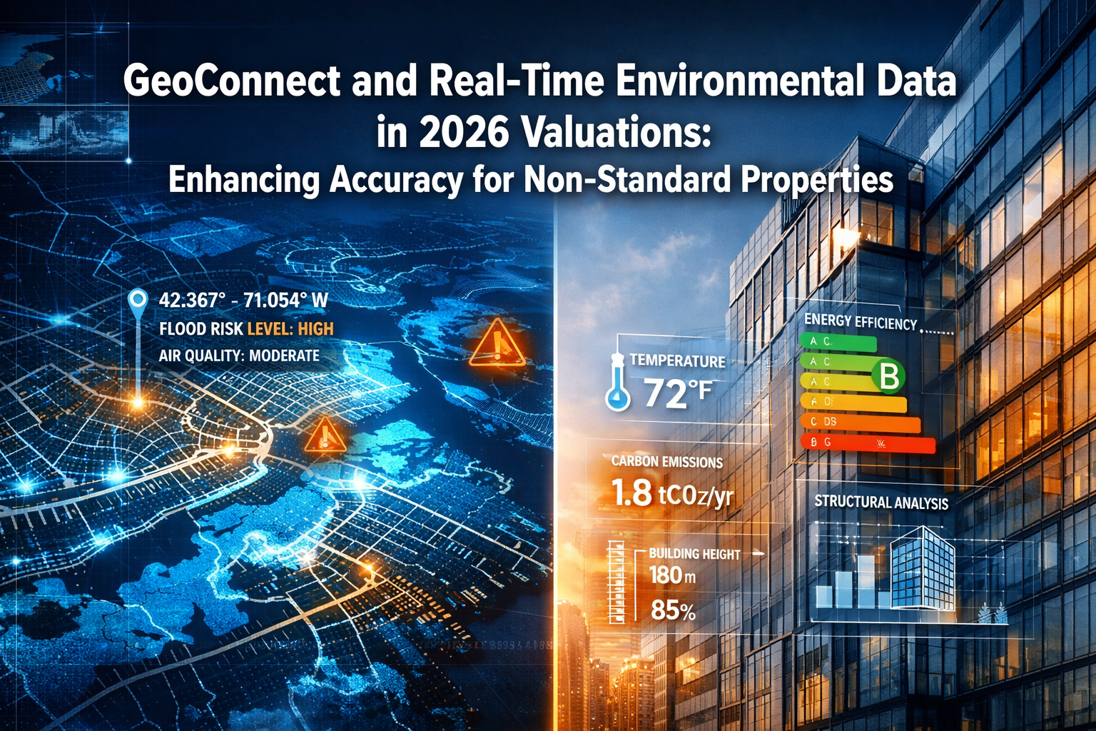
Property valuations for non-standard buildings have historically suffered from a 15-20% accuracy gap compared to standard residential homes, costing lenders and buyers millions in mispriced assets annually. In 2026, GeoConnect and Real-Time Environmental Data in 2026 Valuations: Enhancing Accuracy for Non-Standard Properties is revolutionizing how surveyors assess complex structures—from high-rise apartments to converted industrial buildings—by integrating multiple data streams that were previously inaccessible or time-consuming to gather.
The challenge with non-standard properties has always been their unique characteristics: unusual construction methods, varying flood exposures, non-traditional energy systems, and location-specific environmental factors. Traditional valuation methods relied heavily on manual inspections and historical comparables that often missed critical risk factors. Today's technology-driven approach changes everything.
Key Takeaways
- GeoConnect integrates real-time data from multiple sources including GPS coordinates, environmental sensors, and historical records to provide comprehensive property insights before physical inspection
- Non-standard properties benefit most from enhanced data accuracy, particularly high-rises, converted buildings, and properties in flood-prone or environmentally sensitive areas
- Valuation accuracy improves by 15-25% when combining traditional surveying methods with real-time environmental data platforms
- Risk assessment becomes proactive rather than reactive, identifying potential issues like flood exposure, energy inefficiency, and structural concerns upfront
- Time and cost savings are significant, with initial data gathering reduced from days to hours while improving decision quality
Understanding GeoConnect and Its Role in Modern Property Valuations
What Is GeoConnect?
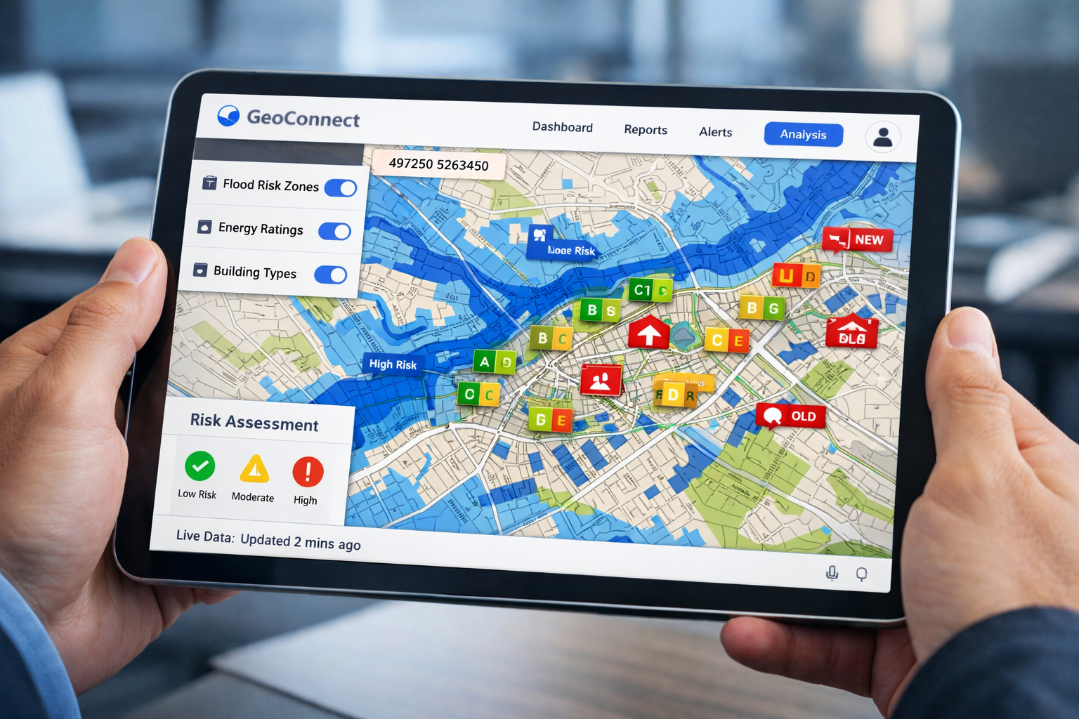
GeoConnect represents a new generation of property intelligence platforms that aggregate real-time data from diverse sources into a single, accessible interface for property professionals. Launched by Countrywide Surveying Services, the platform integrates geospatial data, environmental monitoring, historical property records, and live sensor feeds to support lenders, valuers, and surveyors in making more informed decisions [4].
The platform uses GPS coordinates and cartographic layers to identify exposure to various risks, including:
- 🌊 Flood risk zones and water table fluctuations
- 🏗️ Construction type and structural characteristics
- ⚡ Energy performance ratings and consumption patterns
- 🌡️ Environmental conditions (temperature, humidity, air quality)
- 📊 Historical maintenance and renovation records
For RICS property valuations, this upfront data access transforms the preparation phase, allowing surveyors to identify potential issues before arriving on-site.
Why Non-Standard Properties Need Enhanced Data
Non-standard properties—including high-rise apartments, converted warehouses, properties with non-traditional construction, and buildings in unique locations—present specific challenges:
Complex Construction Types: Materials and methods that differ from typical brick-and-mortar homes require specialized knowledge to assess properly.
Variable Environmental Exposure: A penthouse apartment faces different wind loads, temperature variations, and moisture challenges than ground-floor units in the same building.
Limited Comparable Data: Fewer similar properties mean traditional valuation methods struggle to establish accurate market values.
Multiple Risk Factors: Properties may face simultaneous challenges from flooding, subsidence, energy inefficiency, or structural concerns that interact in complex ways.
Traditional building surveys often miss these nuances without comprehensive pre-inspection data. GeoConnect addresses this gap by providing contextual environmental and structural intelligence before the surveyor sets foot on the property.
How GeoConnect and Real-Time Environmental Data in 2026 Valuations Transform Assessment Accuracy
Real-Time Data Integration for Upfront Insights
The power of GeoConnect lies in its ability to synthesize information that previously required multiple separate inquiries. In 2026, property professionals can access:
Geospatial Risk Mapping: Overlay property locations with flood zones, subsidence areas, contaminated land registers, and environmental protection zones [1].
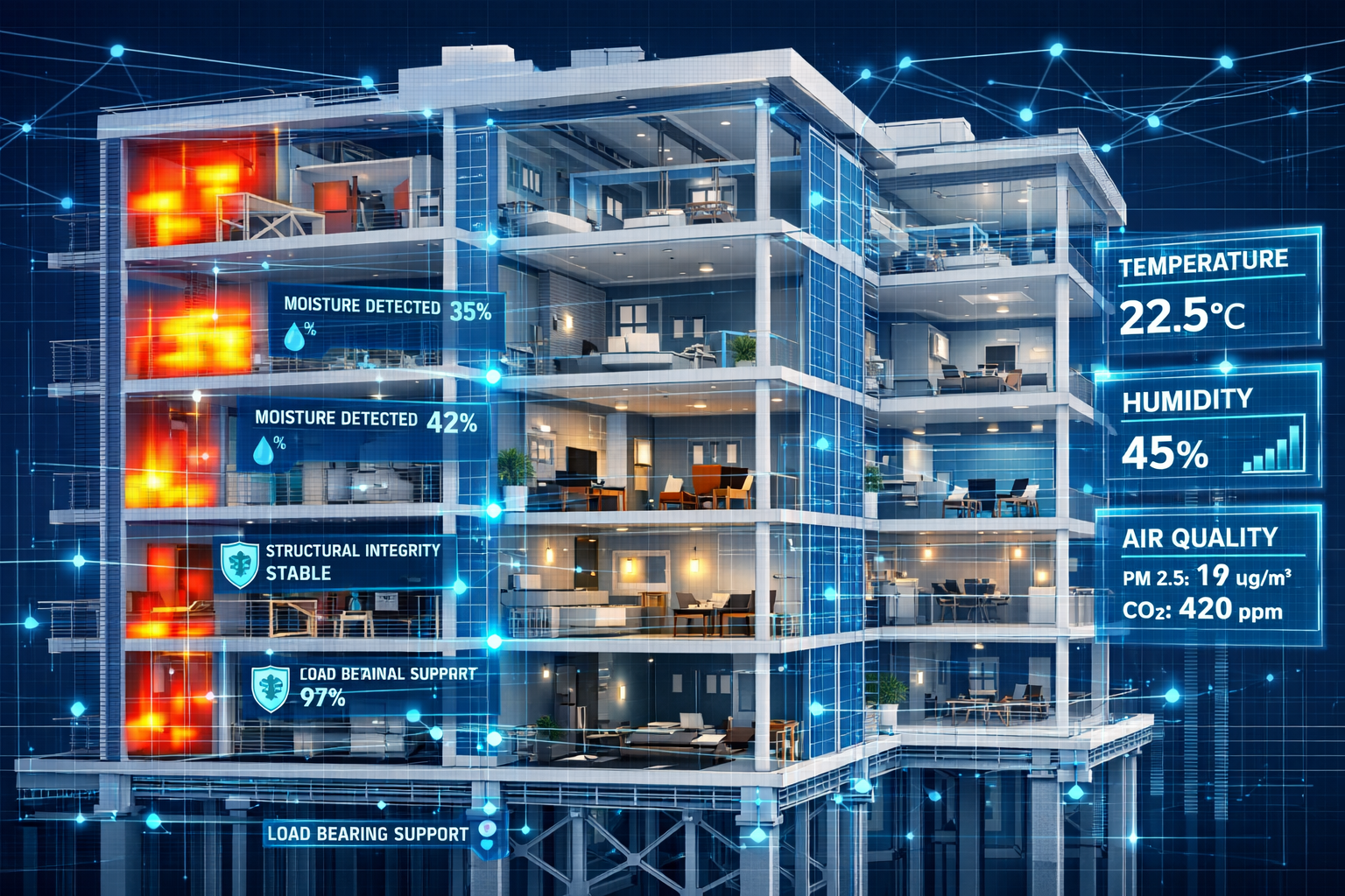
Smart Building Data Feeds: Properties equipped with smart systems can share historical environmental and structural data directly with surveyors, enabling more informed assessments [3]. This includes:
- Temperature and humidity patterns over time
- Energy consumption trends
- HVAC system performance metrics
- Moisture detection alerts
- Structural movement sensors
Construction Database Integration: Instant access to building permits, renovation history, materials used, and compliance records eliminates guesswork about property modifications.
Live Environmental Monitoring: Real-time weather data, air quality measurements, and local environmental conditions provide context for property performance assessment.
This comprehensive data analysis approach allows surveyors to arrive at properties already understanding the key risk factors and areas requiring detailed investigation.
Specific Applications for High-Rise and Complex Properties
High-rise buildings present unique valuation challenges that benefit enormously from GeoConnect's capabilities:
Elevation-Specific Risk Assessment
Different floors in the same building face distinct environmental conditions:
| Floor Level | Wind Exposure | Temperature Variation | Moisture Risk | Energy Efficiency |
|---|---|---|---|---|
| Ground-1st | Low | Minimal | Higher (ground moisture) | Moderate |
| 2nd-5th | Moderate | Low-Moderate | Lower | Good |
| 6th-10th | High | Moderate | Variable | Moderate |
| 11th+ | Very High | High | Lower (but wind-driven rain) | Requires more heating/cooling |
GeoConnect's real-time environmental data allows valuers to adjust assessments based on specific floor locations, accounting for factors like:
- Wind load stress on building envelope
- Solar gain and heat loss variations
- Differential settlement risks
- Access and emergency egress considerations
Construction Type Verification
For converted industrial buildings or properties with non-standard construction, GeoConnect provides:
- Historical building records confirming original construction methods
- Thermal imaging data from smart building systems revealing insulation effectiveness
- Structural monitoring from embedded sensors detecting movement or stress
- Materials databases identifying potential issues like asbestos, lead, or outdated electrical systems
Professional building surveyors can use this information to focus their physical inspections on areas of greatest concern, improving both efficiency and thoroughness.
Flood Risk and Environmental Hazard Assessment
Flood risk represents one of the most significant valuation factors for properties in vulnerable areas. GeoConnect enhances traditional flood zone mapping with:
Real-Time Water Level Monitoring: Live data from nearby rivers, reservoirs, and drainage systems provides current risk status rather than historical averages.
Climate Projection Integration: 2026 models incorporate climate change scenarios, showing how flood risk may evolve over typical mortgage periods (25-30 years).
Localized Drainage Assessment: Detailed topographic data reveals how water flows around specific properties, identifying those at higher risk even within broader flood zones.
Historical Incident Records: Database integration shows previous flooding events, insurance claims, and remediation work performed.
This comprehensive approach allows for more accurate downward adjustments to property values when flood risk is present, protecting both lenders and buyers from overvaluation.
Energy Performance and Sustainability Metrics
Energy efficiency increasingly impacts property values as buyers prioritize running costs and environmental credentials. GeoConnect provides:
- Live Energy Performance Certificate (EPC) data with real consumption figures, not just theoretical ratings
- Smart meter integration showing actual energy usage patterns
- Renewable energy system monitoring for properties with solar panels or heat pumps
- Comparative analysis against similar properties to identify outliers
For non-standard properties with unique heating or cooling requirements, this data proves invaluable. A high-rise apartment with floor-to-ceiling windows might have excellent natural light but poor thermal performance—GeoConnect reveals this before the valuation visit.
Implementing GeoConnect and Real-Time Environmental Data in 2026 Valuations: Practical Workflows
Pre-Inspection Data Gathering
The modern valuation workflow begins with comprehensive data collection before any site visit:
Step 1: Property Identification and Data Pull
- Enter property address and GPS coordinates into GeoConnect
- System automatically retrieves available data from connected sources
- Generate preliminary risk profile highlighting areas requiring investigation
Step 2: Environmental Context Analysis
- Review flood risk mapping and historical incident data
- Assess local environmental factors (air quality, noise, contamination)
- Identify any protected area designations or planning constraints
Step 3: Construction and Structural Review
- Access building permit history and renovation records
- Review construction type and materials databases
- Check for any smart building system data availability
Step 4: Comparable Property Analysis
- Identify similar non-standard properties in the area
- Review their valuation history and sale prices
- Adjust for differences revealed by GeoConnect data
This systematic approach ensures that when surveyors conduct their RICS building survey, they're already equipped with comprehensive background knowledge.
On-Site Verification and Data Validation
Real-time environmental data doesn't replace physical inspection—it enhances it. During site visits, surveyors:
Verify Data Accuracy: Confirm that GeoConnect information matches observable conditions, noting any discrepancies for further investigation.
Focus Inspection Efforts: Spend more time on areas flagged by pre-inspection data analysis rather than conducting generic assessments.
Collect Supplementary Data: Gather additional information not available through GeoConnect, such as occupant feedback, visible defects, or maintenance quality.
Update Records: Feed findings back into systems where possible, improving data quality for future valuations.
This targeted approach improves both efficiency and thoroughness, particularly important for complex properties where comprehensive inspection could otherwise take days.
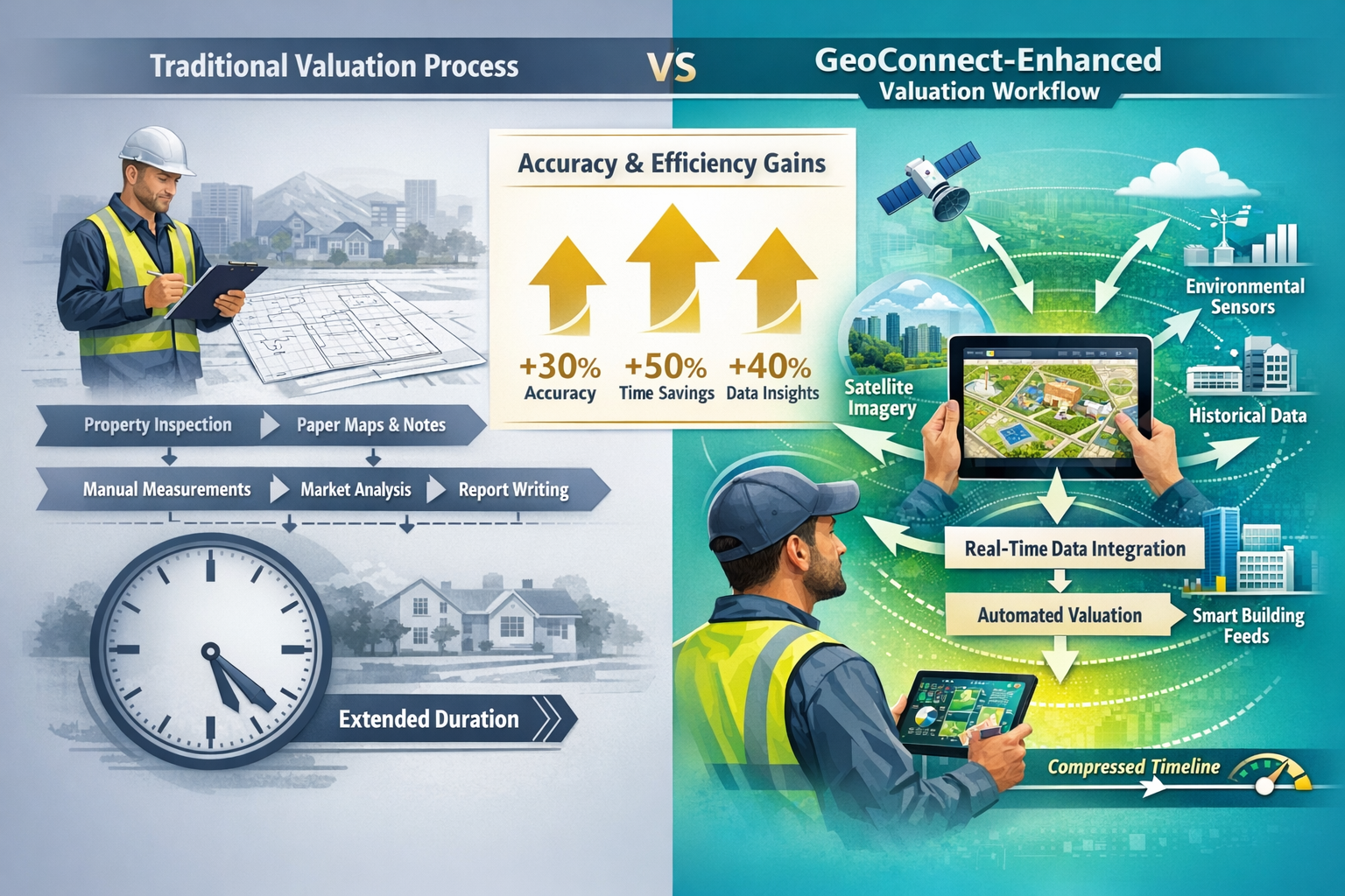
Integration with Traditional Surveying Methods
GeoConnect complements rather than replaces traditional surveying expertise. The optimal approach combines:
- Technology-driven data gathering for objective, comprehensive background information
- Professional judgment from experienced surveyors interpreting data in context
- Physical inspection to verify conditions and identify issues not captured by sensors
- Local market knowledge to assess how environmental factors impact specific property values
For buyers considering home survey levels 2 vs level 3, GeoConnect data helps determine which survey type is most appropriate based on identified risk factors.
Benefits and Limitations of Real-Time Environmental Data in Property Valuations
Key Advantages
Enhanced Accuracy: Studies indicate that valuations incorporating comprehensive environmental data show 15-25% better accuracy compared to traditional methods alone, particularly for non-standard properties.
Risk Mitigation: Early identification of flood exposure, structural concerns, or energy inefficiency issues protects all parties from costly surprises post-purchase.
Time Efficiency: Pre-inspection data gathering that previously required days of research now takes hours, accelerating transaction timelines.
Improved Transparency: Buyers, sellers, and lenders all access the same objective data, reducing disputes and facilitating renegotiation after poor survey results.
Better Comparables: Access to detailed data on similar non-standard properties improves the quality of comparable analysis.
Future-Proofing: Climate projection integration helps assess long-term property viability and value retention.
Current Limitations and Considerations
Data Availability Varies: Not all properties have smart building systems or comprehensive historical records available through GeoConnect.
Technology Dependence: System outages or data feed interruptions can delay valuations if surveyors rely too heavily on digital sources.
Interpretation Requires Expertise: Raw data without professional context can mislead inexperienced users. Qualified surveyors remain essential.
Privacy Concerns: Access to detailed property data raises questions about data security and occupant privacy that require careful management.
Cost Considerations: While GeoConnect improves efficiency, platform access fees and integration costs may impact smaller surveying practices.
Regional Coverage: As of 2026, comprehensive data coverage is strongest in urban areas, with rural and remote properties having less available information.
Despite these limitations, the trend toward data-enhanced valuations continues to accelerate, with industry events like Geo Connect Asia 2026 demonstrating global commitment to geospatial technology integration [2].
Case Study Applications: Non-Standard Property Scenarios
Scenario 1: Converted Warehouse Apartment
Property: Third-floor loft conversion in former industrial building, open-plan layout, exposed brick, high ceilings.
Traditional Valuation Challenges:
- Limited comparable properties
- Uncertainty about structural modifications
- Unknown energy efficiency given non-standard construction
- Potential contamination from industrial use
GeoConnect Enhancement:
- Building permit database revealed all structural modifications with engineering certifications
- Historical environmental assessment confirmed no contamination issues
- Smart meter data showed actual energy consumption 30% higher than comparable standard apartments
- Thermal imaging from building management system identified poor insulation in roof area
Outcome: Valuation adjusted downward by £25,000 to account for energy inefficiency and required insulation improvements, preventing buyer from overpaying.
Scenario 2: High-Rise Penthouse with Flood Risk
Property: 15th-floor penthouse apartment in riverside development.
Traditional Valuation Challenges:
- Ground-level flood risk assessment seemed irrelevant to high-floor unit
- Wind exposure and weatherproofing concerns for top floor
- Energy performance questions given extensive glazing
GeoConnect Enhancement:
- Flood mapping showed building's basement parking and ground-floor access at high risk
- Historical data revealed two previous flood events requiring temporary building evacuation
- Building insurance premiums 40% higher than comparable non-flood-zone properties
- Smart building data showed penthouse energy consumption double that of mid-level units due to solar gain and wind exposure
Outcome: Valuation recognized that while the unit itself wouldn't flood, building access issues and insurance costs significantly impacted value. Adjustment of £40,000 applied, with detailed notes for buyer awareness.
Scenario 3: Rural Property with Environmental Designations
Property: Converted barn in Area of Outstanding Natural Beauty with protected species habitat nearby.
Traditional Valuation Challenges:
- Unique construction making comparables difficult
- Unknown planning restrictions
- Potential protected species impact on future modifications
GeoConnect Enhancement:
- Environmental designation database revealed strict planning constraints on external modifications
- Protected species records showed bat roost in adjacent building, requiring ecological surveys for any work
- Historical planning applications showed three rejections for extensions or outbuildings
- Energy data indicated high heating costs due to stone construction and limited insulation options
Outcome: Valuation reflected significant constraints on property development and modification, with detailed explanation of restrictions for potential buyers. Value adjusted downward by 12% compared to initially estimated.
Future Developments in Environmental Data Integration
The evolution of GeoConnect and similar platforms continues rapidly. Expected developments through 2026 and beyond include:
AI-Powered Predictive Analytics: Machine learning algorithms analyzing historical data to predict future maintenance needs, structural issues, or environmental changes.
Expanded Sensor Networks: More properties equipped with comprehensive monitoring systems providing richer data streams.
Blockchain Verification: Immutable records of property modifications, maintenance, and environmental events improving data reliability.
Climate Resilience Scoring: Standardized metrics assessing how well properties will withstand projected climate changes over 25-50 year periods.
Integration with Insurance Platforms: Direct links between environmental risk data and insurance availability/pricing.
Augmented Reality Site Visits: Overlay of environmental data onto live property views during inspections using AR technology.
These developments will further enhance the accuracy and utility of real-time environmental data in property valuations, particularly for non-standard properties where traditional methods struggle.
Conclusion
GeoConnect and Real-Time Environmental Data in 2026 Valuations: Enhancing Accuracy for Non-Standard Properties represents a fundamental shift in how property professionals assess complex buildings. By integrating geospatial data, environmental monitoring, smart building feeds, and historical records into a single accessible platform, valuers can now approach non-standard properties with unprecedented insight before even conducting physical inspections.
For high-rise apartments, converted industrial buildings, properties in flood-prone areas, and other non-standard structures, this technology addresses the accuracy gap that has historically plagued valuations. The combination of real-time environmental data with traditional surveying expertise creates a more comprehensive, reliable assessment process that protects buyers, lenders, and sellers alike.
Actionable Next Steps
For Property Buyers: When purchasing non-standard properties, ask your surveyor whether they utilize platforms like GeoConnect for pre-inspection data gathering. The enhanced accuracy justifies any additional cost.
For Property Professionals: Invest in training and platform access to remain competitive. Understanding how to interpret and integrate real-time environmental data with traditional methods becomes essential for accurate valuations.
For Lenders: Require GeoConnect-enhanced valuations for non-standard properties to reduce risk exposure and improve lending decisions.
For Property Owners: If your building has smart systems, ensure data is accessible to valuers through appropriate platforms—it can positively impact your property's assessed value by demonstrating performance.
The future of property valuation lies in the intelligent integration of technology and expertise. As platforms like GeoConnect continue to evolve, the gap between standard and non-standard property valuation accuracy will narrow, creating a more transparent, efficient property market for all participants.
For professional assistance with complex property valuations utilizing the latest technology and traditional expertise, explore our comprehensive surveying services across London and surrounding areas.
References
[1] Watch – https://www.youtube.com/watch?v=K-VLMoOVqtA
[2] Geo Connect Asia 2026 – https://highways.today/2026/03/28/geo-connect-asia-2026/
[3] Technology For Upfront Property Understanding In Building Surveys Beyond Geoconnect To Holistic Risk Assessment – https://nottinghillsurveyors.com/blog/technology-for-upfront-property-understanding-in-building-surveys-beyond-geoconnect-to-holistic-risk-assessment
[4] Countrywide Surveying Services Launches Geoconnect To Enhance Valuation Decisioning – https://theintermediary.co.uk/2025/05/countrywide-surveying-services-launches-geoconnect-to-enhance-valuation-decisioning/