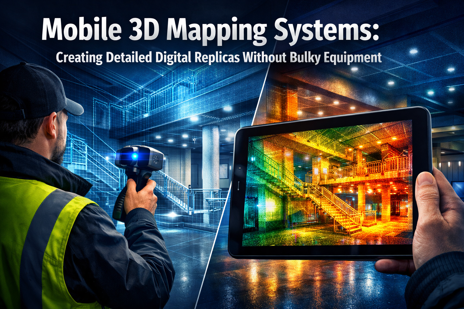
Imagine transforming a complex building interior, sprawling construction site, or historic monument into a precise digital twin—all within hours, using equipment light enough to carry in one hand. This isn't a glimpse into the distant future; it's the reality of mobile 3D mapping systems in 2026. Gone are the days when creating detailed digital replicas required teams of specialists hauling heavy laser scanners, spending weeks on data collection, and enduring months of post-processing. Today's mobile 3D mapping systems are revolutionizing how surveyors, architects, and construction professionals capture spatial data, delivering millimeter-accurate results without the burden of bulky equipment.
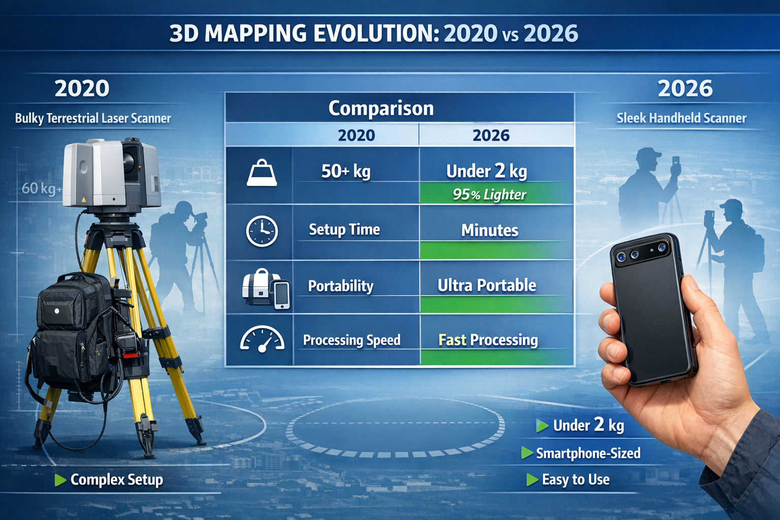
The transformation has been nothing short of remarkable. Traditional terrestrial laser scanning equipment often weighed upwards of 50 kilograms, required extensive setup time, and demanded specialized training to operate effectively. Modern mobile mapping solutions have compressed this technology into handheld devices and smartphone-compatible sensors that anyone can deploy in minutes. This democratization of 3D mapping technology is reshaping industries from property assessment to infrastructure management, making detailed spatial documentation accessible to professionals who previously couldn't justify the investment in expensive, cumbersome equipment.
Key Takeaways
✅ Mobile 3D mapping systems have reduced equipment weight by up to 95% compared to traditional laser scanners, with modern devices weighing under 2 kilograms while maintaining millimeter-level accuracy.
✅ Processing times have decreased dramatically—leading solutions now deliver usable 3D models within 24 hours instead of weeks, with AI-powered automation reducing post-processing time by 60%.[3]
✅ The mobile mapping market reached USD 51.19 billion in 2026 and is projected to grow at 17.95% annually, driven by smart city initiatives and infrastructure modernization.[3]
✅ Real-time visualization capabilities allow surveyors to verify data quality on-site, eliminating costly return visits and ensuring complete coverage before leaving the location.
✅ Cross-industry applications extend from building condition assessment and construction monitoring to heritage preservation and autonomous vehicle navigation, demonstrating unprecedented versatility.
Understanding Mobile 3D Mapping Systems: Creating Detailed Digital Replicas Without Bulky Equipment
What Makes Modern Systems "Mobile"? 📱
The term "mobile" in mobile 3D mapping systems encompasses far more than simple portability. True mobility represents a fundamental shift in how spatial data is captured, processed, and delivered. Modern systems integrate multiple technologies—LiDAR (Light Detection and Ranging), photogrammetry, GNSS (Global Navigation Satellite System), and IMU (Inertial Measurement Unit) sensors—into compact packages that professionals can operate while walking, driving, or even flying.
Key characteristics of mobile 3D mapping systems include:
- Continuous data capture while in motion, eliminating the stop-and-scan approach
- Real-time processing that provides immediate feedback on data quality
- Integrated positioning combining GNSS and IMU for accurate georeferencing
- Multi-sensor fusion that merges laser scanning with high-resolution imagery
- Cloud connectivity enabling instant data upload and collaborative workflows
The evolution toward mobility has been driven by advances in sensor miniaturization, battery technology, and computational power. What once required rack-mounted computers can now run on processors embedded within handheld devices. This technological convergence has made mobile 3D mapping systems practical for everyday surveying tasks, from structural defect documentation to comprehensive site surveys.
The Technology Behind Lightweight 3D Capture
Modern mobile 3D mapping systems leverage several complementary technologies to achieve professional-grade results without bulky equipment. LiDAR sensors form the backbone of most systems, emitting laser pulses that measure distances with millimeter precision. Contemporary mobile LiDAR units can capture up to 300,000 points per second while weighing less than a smartphone.
Photogrammetry complements LiDAR by extracting 3D geometry from overlapping photographs. Advanced algorithms process these images to generate textured 3D models that provide visual context alongside geometric accuracy. This dual approach—combining laser precision with photographic detail—creates comprehensive digital replicas that serve multiple purposes.
Recent innovations have further enhanced mobile mapping capabilities. Trimble's MX90 system, launched in February 2025, exemplifies this progress by capturing laser scans and imagery at highway speeds, enabling rapid infrastructure inspections without traffic disruption.[3] Similarly, Pix4D's integration of Topcon CR-H1 GNSS support into PIX4Dcatch in May 2025 brought precise handheld 3D scanning to iOS devices equipped with LiDAR sensors.[3]
The breakthrough in mobile 3D mapping systems extends beyond hardware miniaturization. Artificial intelligence now plays a crucial role in data processing. Trimble's TBC 2024.10 software, released in March 2025, introduced customizable AI point extraction and automated lane-line detection, with early adopters reporting a 60% reduction in post-processing time.[3] This dramatic improvement means field crews can complete projects and redeploy within 24 hours instead of waiting weeks for data processing.
Comparing Mobile vs. Traditional Mapping Equipment
| Feature | Traditional Laser Scanners | Mobile 3D Mapping Systems |
|---|---|---|
| Weight | 40-60 kg (including tripod & accessories) | 0.5-2 kg (handheld units) |
| Setup Time | 15-30 minutes per station | 2-5 minutes total |
| Data Collection | Static, station-based | Continuous while moving |
| Coverage Speed | 500-1,000 m²/hour | 5,000-50,000 m²/hour |
| Processing Time | 2-4 weeks typical | 24-48 hours with AI automation |
| Operator Training | 2-4 weeks specialized training | 1-2 days basic operation |
| Cost Range | £50,000-£150,000+ | £5,000-£40,000 |
| Accuracy | ±1-2 mm | ±2-5 mm (high-end mobile) |
This comparison reveals why mobile 3D mapping systems have gained such rapid adoption. While traditional scanners maintain a slight accuracy advantage in controlled environments, mobile systems deliver sufficient precision for the vast majority of applications while dramatically reducing project timelines and costs.
Real-World Applications of Mobile 3D Mapping Systems: Creating Detailed Digital Replicas Without Bulky Equipment
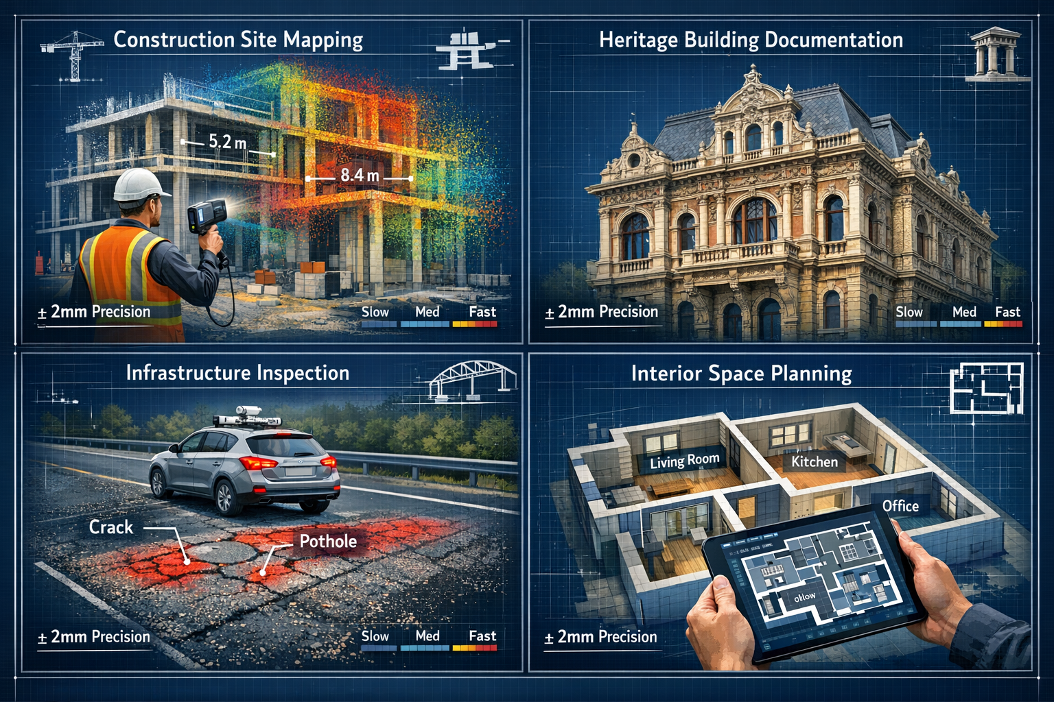
Construction and Infrastructure Documentation 🏗️
The construction industry has embraced mobile 3D mapping systems as essential tools for project monitoring and quality control. Contractors now conduct weekly progress scans using handheld devices, comparing as-built conditions against BIM (Building Information Modeling) models to identify deviations before they become costly problems. This proactive approach to building surveying prevents rework and ensures projects stay on schedule.
Infrastructure applications demonstrate particular value from mobile mapping's speed and coverage capabilities. Transportation departments deploy vehicle-mounted systems to survey hundreds of kilometers of roadway in days, capturing pavement conditions, signage locations, and structural details of bridges and tunnels. The data supports asset management programs, maintenance planning, and safety improvements without disrupting traffic flow.
Leica Geosystems' Pegasus TRK300, introduced in May 2025, exemplifies purpose-built infrastructure solutions. Its dual-head multi-beam scanner offers a 300-meter range specifically designed for smart-city and infrastructure projects, enabling rapid documentation of urban environments.[3] This extended range proves invaluable for surveying wide corridors, large facilities, and complex transportation networks where traditional scanning would require hundreds of individual setups.
The integration of mobile 3D mapping systems with construction workflows extends beyond documentation. Reality capture data now feeds directly into project management platforms, enabling automated quantity takeoffs, clash detection, and progress billing based on verified completion percentages. This seamless integration transforms raw spatial data into actionable business intelligence.
Property Surveying and Building Assessment 🏘️
For property surveyors, mobile 3D mapping systems have revolutionized how RICS surveys and building assessments are conducted. Handheld scanners enable comprehensive documentation of property conditions in a fraction of the time required for traditional measurement methods. A surveyor can now capture complete interior and exterior geometry of a residential property in 30-60 minutes, generating floor plans, elevations, and detailed condition reports from a single visit.
This efficiency proves particularly valuable for homebuyers surveys and structural assessments. The detailed 3D data provides objective evidence of property conditions, supporting accurate valuations and identifying potential issues like structural movement, damp penetration, or subsidence. Clients receive interactive 3D models they can explore remotely, improving transparency and understanding of survey findings.
Heritage building documentation represents another critical application. Mobile mapping systems capture intricate architectural details of historic structures without physical contact, preserving cultural assets in digital form while supporting restoration planning. The non-invasive nature of laser scanning makes it ideal for documenting fragile or protected buildings where traditional measurement methods might cause damage.
The technology also streamlines boundary dispute resolution by providing precise measurements of property lines, encroachments, and shared structures. The objective spatial data serves as compelling evidence in negotiations or legal proceedings, often resolving disputes without costly litigation.
Emerging Applications in Automotive and Robotics 🚗
Beyond traditional surveying applications, mobile 3D mapping systems are enabling breakthrough innovations in automotive technology and robotics. Mapbox's 3D Lanes feature, announced at CES 2026 in January, demonstrates how precise mobile mapping data enhances navigation systems. The feature provides true-to-life road detail through the Mapbox Navigation SDK, supporting both in-vehicle and mobile use cases.[1]
Cabin perception mapping represents another frontier. Seeing Machines showcased next-generation 3D Cabin Perception Mapping technology at CES 2026, delivering real-time digital reconstruction of vehicle cabin environments. The system uses three cameras to cover three rows of seating, supporting up to seven vehicle occupants simultaneously.[2]
The technology's capabilities extend far beyond simple occupancy detection. The system provides:
- Body size, shape, and full 3D pose solutions for all occupants
- Height and weight classification for optimized airbag deployment
- Out-of-position detection (driver reclining, feet on dashboard, proximity to airbags)
- Child seat detection across the entire cabin
- Random object identification (phones, bags, boxes)
- Seat configuration details (headrest presence, position, recline angle)[2]
Unlike traditional feature-by-feature approaches, this unified architecture processes the entire cabin simultaneously, improving consistency across features and maintaining accuracy even with intermittent or noisy sensor data.[2] The platform extends beyond automotive applications to robotics and human-machine interaction environments, supporting flexible deployment as sensing hardware and use cases evolve.[2]
These automotive applications demonstrate how mobile 3D mapping systems are transcending their surveying origins to become fundamental components of intelligent systems that perceive and respond to three-dimensional environments in real time.
Implementing Mobile 3D Mapping Systems: Creating Detailed Digital Replicas Without Bulky Equipment
Choosing the Right Mobile Mapping Solution 🎯
Selecting appropriate mobile 3D mapping systems requires careful consideration of project requirements, accuracy needs, and budget constraints. The market offers solutions ranging from smartphone-based photogrammetry apps to professional-grade LiDAR systems, each suited to different applications and skill levels.
Entry-level solutions leverage smartphone cameras and built-in sensors to create 3D models through photogrammetry. These systems cost little beyond the smartphone itself and deliver sufficient accuracy for basic documentation, space planning, and preliminary surveys. iOS devices with LiDAR sensors (iPhone 12 Pro and later, iPad Pro models) offer enhanced capabilities, capturing spatial data with centimeter-level accuracy suitable for many professional applications.
Mid-range handheld scanners provide dedicated LiDAR sensors, improved range, and professional-grade accuracy (±2-5mm). These devices typically cost £5,000-£20,000 and represent the sweet spot for surveying firms, architects, and construction professionals who need reliable performance without enterprise-level investment. Popular options include systems from Leica, Trimble, and Faro, offering varying combinations of range, accuracy, and processing capabilities.
Professional vehicle-mounted systems serve large-scale infrastructure projects, offering the highest productivity for corridor mapping and urban documentation. These solutions cost £40,000-£150,000+ but can survey hundreds of kilometers daily, making them cost-effective for transportation departments, utilities, and mapping companies with substantial project volumes.
Key selection criteria include:
- Accuracy requirements for your typical projects
- Range and coverage needed per scan session
- Processing workflow integration with existing software
- Training and support availability from the manufacturer
- Total cost of ownership including software licenses and maintenance
- Deliverable formats required by clients or project specifications
Best Practices for Data Capture and Processing
Successful implementation of mobile 3D mapping systems depends on following proven workflows that maximize data quality while minimizing collection time. Pre-survey planning remains essential even with mobile systems—walking the site, identifying challenging areas (reflective surfaces, dark materials, narrow spaces), and determining optimal scanning paths ensures complete coverage without gaps.
Data capture techniques vary by system type but share common principles:
- Maintain consistent walking speed (typically 0.5-1.0 m/s for handheld scanners)
- Ensure adequate overlap between scan passes (30-50% minimum)
- Capture control points or reference targets for georeferencing and accuracy verification
- Monitor real-time feedback to identify coverage gaps before leaving the site
- Document challenging conditions (lighting, weather, obstructions) that may affect data quality
Post-processing workflows have been dramatically streamlined by AI automation. Modern software automatically registers scan data, removes noise, classifies point clouds, and extracts features like walls, floors, and structural elements. The surveyor's role shifts from manual data manipulation to quality control and deliverable preparation.
Trimble's breakthrough with 60% processing time reduction through AI-powered automation exemplifies this transformation.[3] Tasks that previously required skilled technicians working for days now complete automatically overnight, freeing professionals to focus on analysis and client communication rather than data manipulation.
Quality assurance remains critical despite automation. Experienced surveyors verify:
- Registration accuracy by checking tie points and control measurements
- Completeness ensuring all required areas were captured adequately
- Classification correctness reviewing automated feature extraction results
- Deliverable accuracy confirming final outputs meet project specifications
Integration with Existing Workflows and Software
The true value of mobile 3D mapping systems emerges through seamless integration with existing professional workflows. Modern systems export data in industry-standard formats compatible with CAD, BIM, and GIS platforms, ensuring captured spatial information flows directly into design, analysis, and documentation processes.
BIM integration represents a particularly powerful application. Point cloud data from mobile scanners imports directly into Revit, ArchiCAD, and other BIM platforms, enabling as-built modeling, clash detection, and design verification. This integration supports home renovation projects by providing accurate existing conditions documentation that informs design decisions and prevents costly field conflicts.
CAD workflows benefit from automated floor plan generation, elevation extraction, and cross-section creation directly from scan data. What once required hours of manual measurement and drafting now happens automatically, with the surveyor refining and annotating computer-generated drawings rather than creating them from scratch.
Cloud-based collaboration platforms enable real-time sharing of 3D data with project stakeholders. Clients, architects, contractors, and consultants access interactive models through web browsers, reviewing progress, taking measurements, and adding annotations without specialized software. This transparency improves communication and reduces misunderstandings that lead to project delays.
The integration extends to specialized applications like party wall agreements, where precise documentation of existing conditions protects both building owners and neighbors during construction work. The objective 3D record provides indisputable evidence of pre-construction conditions, preventing disputes and supporting fair resolution if issues arise.
The Future of Mobile 3D Mapping Systems: Creating Detailed Digital Replicas Without Bulky Equipment
Market Growth and Technology Trends 📈
The mobile mapping system market is experiencing explosive growth, valued at USD 51.19 billion in 2026 and projected to reach USD 116.86 billion by 2031, representing a compound annual growth rate of 17.95%.[3] This remarkable expansion reflects increasing adoption across multiple industries and ongoing technological advancement that continues to improve capabilities while reducing costs.
Key growth drivers include:
- Smart city initiatives requiring comprehensive urban digital twins
- Infrastructure modernization programs demanding efficient asset documentation
- Autonomous vehicle development needing high-definition 3D maps
- Construction digitalization embracing reality capture for project management
- Heritage preservation efforts documenting cultural assets before deterioration
- Climate adaptation planning requiring detailed terrain and built environment models
Technological trends shaping the future of mobile 3D mapping systems point toward even greater accessibility and capability. Sensor costs continue declining while performance improves, making professional-grade systems affordable for smaller firms and individual practitioners. Processing automation powered by machine learning will further reduce the technical expertise required, enabling broader adoption across industries.
Real-time processing represents the next frontier. Current systems typically require post-processing to generate final deliverables, but emerging solutions perform registration, classification, and feature extraction on-device during capture. This capability enables immediate verification and instant deliverable generation, compressing project timelines from days to hours.
Artificial Intelligence and Automated Feature Extraction 🤖
Artificial intelligence is transforming mobile 3D mapping systems from data capture tools into intelligent analysis platforms. Modern AI algorithms automatically identify and classify objects within point clouds—walls, doors, windows, pipes, electrical fixtures, vegetation, pavement markings, and thousands of other features—without human intervention.
This automated extraction delivers multiple benefits:
- Consistency in feature identification across projects and operators
- Speed processing millions of points in minutes rather than days
- Completeness detecting features human operators might overlook
- Standardization ensuring deliverables meet specification requirements
- Cost reduction minimizing labor-intensive manual classification
The 60% processing time reduction achieved by Trimble's AI-powered solutions demonstrates the practical impact.[3] Transportation departments that previously waited weeks for processed data now receive usable results within 24 hours, enabling rapid decision-making and eliminating project delays caused by data bottlenecks.
Machine learning continues advancing, with neural networks trained on billions of labeled examples achieving near-human accuracy in complex classification tasks. Future systems will understand context—recognizing that a cylindrical object near a ceiling is likely a pipe rather than a column, or that regular pavement markings indicate lane boundaries requiring specific documentation.
Democratization and Accessibility
Perhaps the most significant trend in mobile 3D mapping systems is their increasing accessibility to non-specialists. What began as highly technical equipment requiring extensive training is evolving into user-friendly tools that professionals across disciplines can deploy effectively with minimal instruction.
Smartphone-based solutions exemplify this democratization. Millions of professionals now carry LiDAR-equipped devices in their pockets, capable of capturing spatial data sufficient for many applications. While these consumer-grade systems don't match professional scanner accuracy, they enable quick documentation, preliminary surveys, and client communication that previously required specialized equipment and expertise.
Simplified workflows remove technical barriers to adoption. Modern systems guide users through capture processes with visual feedback, automatically adjust settings for optimal results, and provide quality indicators that help non-experts achieve professional results. This user-centric design philosophy makes mobile 3D mapping systems practical tools for architects, facility managers, real estate professionals, and others who need spatial documentation but lack surveying backgrounds.
The implications extend beyond individual practitioners. As 3D capture becomes ubiquitous, expectations shift—clients increasingly expect detailed spatial documentation as standard practice rather than premium service. This normalization drives further adoption, creating a virtuous cycle where improved technology enables broader use, which justifies continued development and cost reduction.
Overcoming Challenges and Limitations

Accuracy Considerations and Quality Control ⚖️
While mobile 3D mapping systems deliver impressive results, understanding their accuracy limitations and implementing appropriate quality control measures remains essential for professional applications. Mobile systems typically achieve ±2-5mm accuracy under optimal conditions, compared to ±1-2mm for high-end terrestrial scanners. This difference matters little for many applications but becomes critical for precision engineering, manufacturing, or deformation monitoring.
Factors affecting mobile mapping accuracy include:
- GNSS signal quality in urban canyons or indoor environments
- Lighting conditions for photogrammetry-based systems
- Surface properties (reflectivity, color, texture)
- Movement speed and stability during capture
- Environmental conditions (temperature, humidity, vibration)
- Calibration status of sensors and positioning systems
Quality control protocols mitigate these factors through systematic verification. Professional surveyors establish control networks using traditional survey methods, capturing reference measurements that validate mobile mapping results. Discrepancies between control points and scan data indicate systematic errors requiring correction or recapture.
Redundant coverage provides another quality safeguard. Capturing areas from multiple directions and positions enables cross-verification, with consistent measurements across different scan passes confirming data reliability. Modern processing software automatically identifies inconsistencies, flagging areas requiring review or additional capture.
For critical applications like structural surveys or boundary determinations, combining mobile mapping with targeted traditional measurements provides optimal results—using mobile systems for comprehensive coverage while deploying precise instruments for critical dimensions and control.
Data Management and Storage Requirements 💾
The comprehensive coverage enabled by mobile 3D mapping systems creates substantial data management challenges. A single handheld scan session might generate 50-200 gigabytes of raw data, while vehicle-based systems can produce terabytes daily. Managing, storing, and processing these massive datasets requires robust infrastructure and systematic workflows.
Storage solutions range from local servers to cloud platforms, each offering distinct advantages. Local storage provides complete control and eliminates ongoing subscription costs but requires significant upfront investment and IT expertise. Cloud platforms offer scalability and accessibility but introduce recurring costs and potential security concerns for sensitive projects.
Data lifecycle management becomes critical as project volumes grow. Organizations must establish policies for:
- Active project storage with fast access for ongoing work
- Archive storage for completed projects requiring occasional retrieval
- Retention periods balancing legal requirements against storage costs
- Backup strategies protecting against data loss
- Deletion protocols securely removing obsolete data
Processing infrastructure similarly demands consideration. While modern laptops handle small projects adequately, professional workflows benefit from dedicated workstations with powerful GPUs, substantial RAM (64GB+), and fast SSD storage. Cloud-based processing services offer alternatives, enabling firms to access supercomputer-level performance without capital investment.
Training and Skill Development
Successful implementation of mobile 3D mapping systems requires appropriate training, though modern systems demand far less expertise than traditional equipment. Basic operation training typically requires 1-2 days, covering equipment setup, data capture techniques, and quality verification. However, developing true proficiency—understanding when and how to apply mobile mapping effectively—requires practical experience across diverse projects.
Training pathways include:
- Manufacturer courses covering specific equipment operation and workflows
- Professional development through surveying associations and industry organizations
- Online tutorials and user communities sharing techniques and solutions
- Mentorship programs pairing experienced practitioners with newcomers
- Certification programs validating competency for professional practice
Software proficiency represents an equally important skill component. While data capture has become more accessible, extracting maximum value from scan data requires understanding processing software, deliverable formats, and integration workflows. Many organizations find that investing in software training yields greater productivity improvements than equipment upgrades.
The democratization of mobile 3D mapping systems doesn't eliminate the value of professional expertise—it shifts the focus from equipment operation to application knowledge, quality judgment, and effective communication of results. The most successful practitioners combine technical proficiency with deep understanding of their industry's requirements, delivering insights rather than merely data.
Conclusion
Mobile 3D mapping systems have fundamentally transformed how professionals create detailed digital replicas of physical environments. The evolution from bulky, expensive equipment requiring specialized expertise to portable, user-friendly systems accessible to diverse practitioners represents one of the most significant technological shifts in surveying and spatial documentation. With the market reaching USD 51.19 billion in 2026 and processing times reduced by 60% through AI automation, the technology has matured from experimental innovation to essential professional tool.[3]
The benefits extend far beyond equipment portability. Mobile 3D mapping systems enable comprehensive documentation that was previously impractical due to time and cost constraints. Surveyors now capture complete building interiors in hours rather than days, transportation departments survey hundreds of kilometers of infrastructure weekly, and construction teams monitor progress continuously rather than periodically. This comprehensive spatial data supports better decision-making across the project lifecycle, from initial property assessment through design, construction, and facility management.
The integration of artificial intelligence, real-time processing, and cloud collaboration continues advancing capabilities while reducing technical barriers. Future systems will deliver even greater automation, accuracy, and accessibility, making detailed 3D documentation standard practice across industries. As Seeing Machines' cabin perception technology and Mapbox's 3D navigation features demonstrate, mobile mapping applications extend far beyond traditional surveying into automotive, robotics, and human-machine interaction domains.[1][2]
Actionable Next Steps 🎯
For professionals considering mobile 3D mapping systems, the path forward depends on current needs and future objectives:
Immediate actions:
- Assess your requirements—identify projects where mobile mapping would deliver the greatest value, considering accuracy needs, coverage requirements, and deliverable formats
- Research available systems—compare equipment options within your budget, focusing on solutions that integrate with existing workflows and software
- Start small—consider smartphone-based solutions or equipment rental for initial projects, gaining practical experience before major investment
- Develop skills—pursue training through manufacturers, professional organizations, or online resources to build competency
- Establish workflows—create systematic processes for data capture, processing, quality control, and deliverable generation
Strategic considerations:
- Monitor technology trends—stay informed about emerging capabilities, particularly AI-powered automation and real-time processing
- Build partnerships—connect with equipment suppliers, software vendors, and peer practitioners to share knowledge and resources
- Communicate value—educate clients about mobile mapping benefits, positioning comprehensive 3D documentation as standard rather than premium service
- Plan infrastructure—ensure adequate data storage, processing capability, and backup systems to support growing project volumes
- Invest in expertise—prioritize ongoing skill development, recognizing that technology evolution requires continuous learning
The transformation from bulky equipment to portable systems has made detailed digital replicas accessible to professionals across industries. Whether conducting RICS surveys, documenting building conditions, or managing infrastructure assets, mobile 3D mapping systems provide the spatial intelligence required for informed decision-making in 2026 and beyond. The question is no longer whether to adopt mobile mapping technology, but how quickly to implement it and how effectively to leverage its capabilities for competitive advantage.
References
[1] Watch – https://www.youtube.com/watch?v=918Xgc_CLjo
[2] Seeing Machines Breaks New Ground At Ces 2026 With 3d Cabin Perception Mapping 302659625 – https://www.prnewswire.com/news-releases/seeing-machines-breaks-new-ground-at-ces-2026-with-3d-cabin-perception-mapping-302659625.html
[3] Mobile Mapping System Market Industry – https://www.mordorintelligence.com/industry-reports/mobile-mapping-system-market-industry
[4] Real World Applications Of Mobile Mapping Systems – https://castlesurveys.co.uk/real-world-applications-of-mobile-mapping-systems/
[5] roboticstomorrow – https://www.roboticstomorrow.com/article/2026/01/3d-mobile-mapping-for-digital-twins-camera-features-that-ensure-accuracy/26045
[6] Mobile 3d Mapping Creating Digital Twins Without Bulky Equipment – https://nottinghillsurveyors.com/blog/mobile-3d-mapping-creating-digital-twins-without-bulky-equipment
[7] Mobile Mapping Market Insights Autonomous Vehicles 3 D Data And Industry Forecast To 2033 – https://vocal.media/futurism/mobile-mapping-market-insights-autonomous-vehicles-3-d-data-and-industry-forecast-to-2033