When planning to purchase property, build a new home, or resolve a boundary dispute in 2026, understanding land survey costs has become more critical than ever. With inflation continuing to impact the construction and real estate sectors, Land Survey Costs in 2026: Complete Pricing Guide, Factors, and How to Save Money Amid Rising Inflation provides essential information for homeowners, developers, and property investors navigating today's economic landscape. 🏡📊
The surveying industry has experienced moderate cost increases over the past few years, driven by technological advancements, increased demand from construction booms, and general inflationary pressures. While these factors have pushed prices upward, they've also introduced new opportunities for cost savings through improved efficiency and competitive market dynamics.
This comprehensive guide breaks down everything needed to make informed decisions about land surveying expenses, from understanding baseline costs to identifying factors that influence pricing and discovering practical strategies to reduce expenses without compromising quality.
Key Takeaways
- Average costs range from $800 to $5,500 for most residential properties, with a national average of approximately $2,300 in 2026[3]
- Property size significantly impacts pricing, with per-acre costs decreasing substantially for larger parcels (from $500-$1,000 per acre for small lots to $70-$140 per acre for 50-100 acre properties)[2]
- Regional variations create price differences of 200% or more, with urban areas like New York or San Francisco charging upwards of $1,500 compared to rural areas at $500 or less for similar services[1]
- Terrain complexity, accessibility, and lot shape can add 25-50% to baseline costs, making these factors crucial in budget planning
- Strategic timing, comparison shopping, and bundling services can reduce total survey expenses by 15-30% without sacrificing quality
Understanding Land Survey Costs in 2026
What Is a Land Survey?
A land survey represents a professional assessment that establishes precise property boundaries, identifies easements, locates improvements, and documents topographical features. Licensed surveyors use specialized equipment—from traditional transits and measuring chains to modern GPS technology and laser scanning devices—to create legally binding documentation of property characteristics.
These surveys serve multiple essential purposes: establishing clear property lines, supporting real estate transactions, facilitating construction projects, resolving boundary disputes, and ensuring compliance with zoning regulations. The accuracy and legal standing of professional surveys make them invaluable investments for property owners.
National Average Pricing in 2026
According to current market data, most homeowners pay between $800 and $5,500 for land surveys in 2026, with the national average settling around $2,300[3]. However, this broad range reflects significant variation based on multiple factors.
For budget-conscious property owners, basic surveys can start as low as $200 to $475 for tiny urban lots with straightforward boundaries[2][3]. On the opposite end of the spectrum, sprawling rural acreage with complex terrain can reach $25,000 or more[3].
Standard residential surveys typically fall within the $300 to $1,200 range, though more complex assessments can exceed $2,000[1]. These figures represent modest increases from 2024-2025 levels, with inflation accounting for approximately 8-12% of the price growth, while increased demand from construction activity and technological investments contribute additional upward pressure.
How 2026 Costs Compare to Previous Years
The surveying industry has experienced relatively stable pricing compared to other construction-related services. Between 2023 and 2026, land survey costs have increased by approximately 15-20% overall, which tracks closely with general inflation rates during this period.
Several factors have moderated cost increases:
Technology adoption has improved surveyor efficiency, allowing professionals to complete projects faster while maintaining accuracy. GPS-enabled equipment and drone surveying capabilities reduce field time requirements, partially offsetting labor cost increases.
Increased competition in many markets has kept pricing competitive, particularly in suburban areas experiencing rapid development. More licensed surveyors entering the field has expanded capacity and prevented supply constraints from driving excessive price inflation.
Standardization of processes through digital workflows and improved record-keeping systems has reduced administrative overhead, allowing firms to maintain competitive pricing structures.
However, certain cost pressures persist. Labor shortages in skilled trades, including surveying, have pushed wages higher. Equipment costs have risen due to supply chain disruptions and increased demand for advanced technology. Insurance and regulatory compliance expenses continue climbing, adding to operational overhead.
Complete Pricing Guide: Land Survey Costs by Property Size and Type
Residential Property Survey Costs
Understanding how property size affects survey costs helps property owners budget accurately and avoid surprises. The relationship between acreage and total cost isn't linear—larger properties benefit from economies of scale.
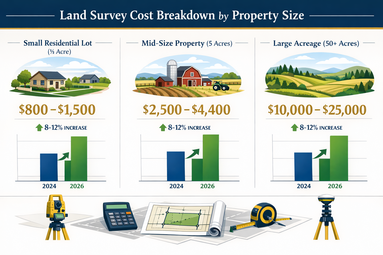
Small Properties (Under 1 Acre)
- 1/5-acre lot: $800–$1,500[3]
- 1/4-acre lot: $900–$1,600
- 1/2-acre lot: $1,000–$2,000[3]
- Single acre: $500–$1,000 (boundary survey)[2]
These smaller residential lots represent the most common survey requests. Urban and suburban properties in this range typically feature relatively straightforward boundaries with existing reference points from neighboring surveys. However, older properties without recent surveys or those in densely developed areas may require additional research, pushing costs toward the higher end of these ranges.
Mid-Sized Properties (2-10 Acres)
- 2-acre property: $1,500–$2,800
- 5-acre property: $2,500–$4,400[3]
- 10-acre property: $3,600–$6,500[3]
Mid-sized properties often involve mixed-use scenarios—residential homes with substantial yards, small hobby farms, or rural building sites. These surveys require more extensive fieldwork but benefit from reduced per-acre costs as property size increases.
Larger Acreage (10+ Acres)
- 25-acre property: $5,500–$12,000[3]
- 50-acre property: $10,000–$25,000[3]
- 100+ acre property: $15,000–$35,000[3]
- Per-acre cost for 50-100 acres: $70–$140[2]
Large parcels demonstrate significant economies of scale, with per-acre costs dropping dramatically. A 100-acre property might cost $20,000 total, representing just $200 per acre—a fraction of the $500-$1,000 per-acre cost for single-acre surveys.
Commercial and Specialized Survey Costs
Commercial properties and specialized survey types often command premium pricing due to increased complexity and liability considerations.
Commercial Property Surveys: $1,500–$10,000+
Commercial surveys require additional detail, including utility locations, parking lot layouts, building setbacks, and compliance with commercial zoning requirements. Multi-building complexes or properties with extensive improvements can easily exceed $10,000.
Topographic Surveys: $500–$6,000
These detailed surveys map elevation changes, drainage patterns, and natural features. Essential for construction planning, topographic surveys vary widely in cost based on property size and terrain complexity. A flat quarter-acre lot might cost $500-$800, while a hilly 10-acre parcel could reach $4,000-$6,000.
ALTA/NSPS Surveys: $2,000–$10,000+
These comprehensive surveys meet American Land Title Association and National Society of Professional Surveyors standards, required for commercial real estate transactions and title insurance. They include extensive detail about improvements, easements, encroachments, and zoning compliance.
For residential property buyers considering comprehensive assessments, understanding different survey types and their purposes helps in selecting appropriate services.
Key Factors Affecting Land Survey Costs in 2026
Property Size and Acreage
Property size represents the most obvious cost driver, but the relationship proves more nuanced than simple multiplication. As demonstrated in the pricing tables above, per-acre costs decrease substantially as total acreage increases[2].
This economy of scale occurs because many survey costs remain relatively fixed regardless of property size. Initial research, travel time, equipment setup, and report preparation require similar effort whether surveying one acre or fifty. The incremental cost of surveying additional contiguous acreage becomes progressively smaller.
However, this principle applies primarily to contiguous parcels with similar characteristics. Surveying multiple disconnected parcels or properties with dramatically varying terrain doesn't benefit from the same economies of scale.
Location and Regional Variations
Geographic location creates perhaps the most dramatic cost variations in land surveying. Urban areas like New York or San Francisco may charge upwards of $1,500 for basic surveys, while rural regions may offer similar services for $500 or less[1].
Several factors drive these regional differences:
Cost of living directly impacts surveyor wages and operational expenses. Firms in high-cost metropolitan areas must charge more to cover rent, insurance, and competitive salaries.
Market demand influences pricing power. Areas experiencing construction booms or high real estate transaction volumes can support premium pricing, while regions with slower activity face competitive pressure to reduce rates.
Regulatory complexity varies by jurisdiction. Some municipalities maintain excellent property records and straightforward permitting processes, while others require extensive research and documentation, increasing surveyor time and costs.
Competition levels affect pricing strategies. Markets with numerous surveying firms typically offer more competitive rates than areas with limited providers.
Property owners in high-cost regions should obtain multiple quotes and consider whether slight delays might allow scheduling during slower periods when firms offer more competitive pricing.
Terrain and Accessibility Challenges
Wooded or hilly areas and oddly-shaped lots have the highest price per acre[2]. Terrain complexity significantly impacts the time and effort required to complete accurate surveys.
Flat, cleared land represents the ideal scenario for surveyors. Unobstructed sight lines allow efficient use of surveying equipment, and easy access means crews can move quickly between measurement points.
Wooded properties require additional time to locate boundary markers, establish clear sight lines, and navigate through vegetation. Dense underbrush may necessitate clearing paths for equipment, adding labor hours.
Steep or hilly terrain complicates measurements and requires additional calculations to account for elevation changes. Surveyors may need specialized equipment and must exercise greater caution when working on slopes.
Wetlands or water features present access challenges and may require alternative measurement techniques. Properties with streams, ponds, or marshy areas often require more time and specialized approaches.
Remote locations with poor road access increase travel time and may require all-terrain vehicles or hiking to reach survey points, adding to overall project costs.
Understanding these surveying challenges helps property owners set realistic budget expectations and plan accordingly.
Lot Shape and Boundary Complexity
Property geometry significantly influences survey costs. Basic rectangular lots cost around $380–$750, while irregular lots with eight sides might cost $580–$950, with an estimated $50 additional charge for each extra side beyond a basic rectangular shape[3].
This pricing structure reflects the additional time required to establish and verify each corner point and boundary line. A simple rectangle requires locating four corners and confirming four straight boundary lines. An irregular eight-sided parcel requires identifying eight corners and eight boundary segments, potentially doubling the measurement work.
Curved boundaries add further complexity, as surveyors must establish multiple points along the curve to accurately map its path. Properties with natural boundary features like streams or ridge lines require careful documentation of these irregular features.
Boundary disputes or uncertainties dramatically increase costs. When existing markers are missing, conflicting, or disputed, surveyors must conduct extensive research, potentially including:
- Reviewing historical deeds and plats
- Locating original survey monuments
- Consulting with neighboring property owners
- Researching easements and encroachments
- Providing expert testimony if disputes escalate to legal proceedings
Properties with known or potential boundary disagreements should budget for enhanced survey services and potential legal support.
Legal Considerations and Title Research
Complicated boundary disputes or legal considerations may necessitate more extensive work, further increasing costs[1]. Thorough title research forms the foundation of accurate surveying, but the required depth varies significantly.
Clear title with recent surveys requires minimal research. When previous professional surveys exist and property records are well-maintained, surveyors can efficiently verify existing information and update as needed.
Older properties without recent surveys demand extensive historical research. Surveyors must trace ownership back through multiple transactions, reconcile historical descriptions with modern mapping systems, and locate original monuments that may be decades or centuries old.
Properties with easements require careful documentation of utility rights-of-way, access easements, and other encumbrances. Each easement must be precisely located and mapped, adding to survey complexity.
Subdivided parcels from larger tracts may require establishing new boundaries and creating legal descriptions where none previously existed, involving additional calculation and documentation work.
Properties in areas with poor record-keeping face the highest research costs. Some jurisdictions maintain incomplete or disorganized property records, forcing surveyors to piece together information from multiple sources.
Working with qualified professional surveyors ensures proper handling of complex legal considerations and reduces the risk of costly errors or disputes.
Technology and Equipment Requirements
Modern surveying technology has transformed the industry, creating both cost savings and new expense categories. The equipment and techniques employed significantly impact project costs.
Traditional surveying methods using transits, levels, and measuring chains remain cost-effective for simple projects. These time-tested approaches work well for small, accessible properties with straightforward boundaries.
GPS and GNSS technology enables rapid, highly accurate measurements over large areas. While the equipment represents a significant capital investment for surveying firms, it reduces field time and improves accuracy, often resulting in net cost savings for larger properties.
Drone surveying provides efficient aerial mapping for topographic surveys and large parcels. Unmanned aerial vehicles equipped with cameras and sensors can quickly capture detailed terrain data, though regulatory requirements and equipment costs may add to project expenses.
3D laser scanning offers unprecedented detail for complex properties or situations requiring extensive documentation. While expensive, this technology proves invaluable for commercial properties, historic sites, or projects with extensive improvements.
Digital data processing and computer-aided design software streamline report creation and data management, reducing administrative costs and improving deliverable quality.
The appropriate technology depends on project requirements. Property owners should discuss options with surveyors to understand how different approaches affect both cost and deliverable quality.
How to Save Money on Land Survey Costs in 2026
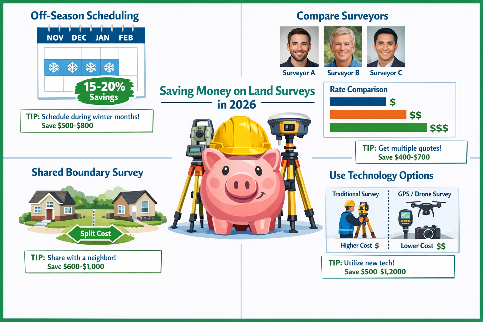
Compare Multiple Surveyor Quotes
In areas where demand for surveying services is high, prices tend to be elevated, while regions with fewer surveyors may offer more competitive pricing[1]. Obtaining quotes from at least three licensed surveyors provides valuable market intelligence and negotiating leverage.
When comparing quotes, consider:
Scope of services: Ensure all quotes include identical deliverables. Some surveyors may offer lower prices but exclude services like monumentation, detailed reports, or digital file delivery.
Timeline: Faster turnaround may command premium pricing, while flexible scheduling might unlock discounts.
Experience and qualifications: The lowest quote isn't always the best value. Experienced surveyors with strong reputations may charge more but deliver superior accuracy and service.
Technology and methods: Understanding the surveying approach helps evaluate whether pricing aligns with the complexity of techniques employed.
Included revisions: Clarify whether quotes include addressing questions or making minor adjustments after initial delivery.
Creating a standardized request for proposal ensures apples-to-apples comparisons and helps identify the best value proposition.
Schedule During Off-Peak Seasons
Surveying demand follows seasonal patterns, with peak activity during spring and summer when weather conditions optimize fieldwork and real estate transactions surge. Strategic timing can yield significant savings.
Winter months (December through February in most regions) represent the slowest period for many surveying firms. While weather may complicate fieldwork in some areas, surveyors often offer discounted rates to maintain steady workflow during slower periods. Savings of 15-20% aren't uncommon for winter scheduling.
Late fall (November) and early spring (March) provide shoulder seasons with moderate weather and reduced demand, potentially offering 10-15% savings compared to peak summer rates.
Mid-week scheduling may also provide modest discounts, as surveyors often face higher demand for weekend and Monday appointments from working professionals.
For projects without urgent deadlines, flexible timing represents one of the easiest ways to reduce costs without compromising quality.
Bundle Services with Neighboring Properties
When multiple adjacent property owners need surveys simultaneously, shared boundary surveys can substantially reduce per-property costs. This approach works particularly well in new subdivisions or situations where neighbors are collaborating on boundary clarification.
Shared setup and research costs represent the primary savings mechanism. Surveyors can amortize travel time, initial research, and equipment setup across multiple properties, reducing per-property charges.
Coordinated boundary establishment allows efficient verification of shared property lines, eliminating duplicate measurements and reducing total field time.
Bulk pricing discounts may be available when contracting for multiple properties simultaneously, as surveyors appreciate the guaranteed volume and scheduling efficiency.
Organizing neighbors to coordinate survey needs requires initiative but can save each property owner 20-30% compared to individual surveys.
Prepare the Property in Advance
Property owners can reduce surveyor field time—and therefore costs—through advance preparation:
Clear boundary areas: Trimming vegetation along suspected property lines provides easier access and clearer sight lines, reducing the time surveyors spend navigating obstacles.
Locate existing markers: Finding and flagging any visible boundary monuments, iron pins, or survey markers helps surveyors work more efficiently.
Gather existing documentation: Providing previous surveys, deeds, plats, and title reports reduces research time and helps surveyors understand property history.
Ensure access: Confirming that all areas of the property are accessible and obtaining any necessary permissions for crossing neighboring land prevents delays.
Mark utility locations: Identifying visible utility lines, septic systems, wells, and other improvements helps surveyors plan their approach and avoid complications.
While surveyors must independently verify all information, advance preparation can reduce field time by several hours on complex properties, translating to meaningful cost savings.
Consider Survey Type Alternatives
Different survey types serve different purposes, and selecting the minimum necessary level of service avoids paying for unnecessary detail.
Mortgage surveys provide basic boundary information sufficient for many residential transactions, typically costing less than comprehensive boundary surveys.
Property line stakeout establishes visible markers at corners and along boundaries without extensive documentation, offering a cost-effective option when detailed reports aren't required.
Boundary surveys provide complete documentation of property lines and are suitable for most residential purposes, including property purchases and fence installation.
ALTA surveys include extensive additional detail required for commercial transactions and title insurance but represent overkill for simple residential needs.
Discussing specific requirements with surveyors helps identify the appropriate service level, avoiding both inadequate surveys that don't meet needs and over-specified surveys that waste money on unnecessary detail.
Verify Surveyor Credentials and Insurance
While not directly reducing costs, ensuring surveyors carry proper licensing and insurance prevents potentially catastrophic expenses from errors or disputes.
State licensing confirms surveyors meet minimum competency standards and maintain continuing education. Unlicensed individuals may offer lower prices but provide no legal recourse if problems arise.
Professional liability insurance (errors and omissions coverage) protects property owners if survey errors cause financial harm. Verifying adequate coverage limits ensures protection against worst-case scenarios.
General liability insurance covers property damage or injuries during survey work, preventing property owners from bearing responsibility for accidents.
Professional association membership in organizations like the National Society of Professional Surveyors indicates commitment to industry standards and ongoing professional development.
Choosing qualified professionals may cost slightly more upfront but provides valuable protection and peace of mind.
Understanding Different Types of Land Surveys and Their Costs
Boundary Survey
Cost Range: $300–$2,000 (residential); $500–$1,000 per acre (small parcels)[1][2]
Boundary surveys represent the most common type, establishing precise property lines and corner locations. These surveys include:
- Research of property deeds and historical records
- Field measurements to locate boundary corners
- Placement of permanent monuments at corners
- Written legal description of boundaries
- Survey plat showing property lines and dimensions
Boundary surveys serve multiple purposes: supporting property purchases, planning fences or improvements, resolving neighbor disputes, and satisfying lender requirements. The comprehensive nature makes them suitable for most residential needs.
Topographic Survey
Cost Range: $500–$6,000
Topographic surveys map elevation changes, contours, and natural features across a property. These specialized surveys prove essential for:
- Architectural and engineering design
- Drainage and grading planning
- Environmental assessments
- Site development planning
- Flood risk evaluation
Costs vary based on property size, terrain complexity, and required detail level. Flat properties need less extensive elevation mapping than hilly terrain, while some projects require highly detailed contour mapping at one-foot intervals or less.
ALTA/NSPS Survey
Cost Range: $2,000–$10,000+
ALTA (American Land Title Association) surveys meet stringent standards developed jointly with the National Society of Professional Surveyors. These comprehensive surveys include:
- All boundary survey elements
- Location of all improvements and structures
- Identification of easements and encroachments
- Zoning classification and setback compliance
- Utility locations and access
- Parking and loading area details
- Detailed title research and exception documentation
Commercial real estate transactions typically require ALTA surveys to satisfy lender and title insurance requirements. The extensive detail and liability associated with these surveys justifies premium pricing.
Subdivision Survey
Cost Range: $2,000–$15,000+
Subdivision surveys divide larger parcels into multiple lots, creating new legal descriptions and establishing individual property boundaries. These complex projects involve:
- Creating subdivision plats showing all new lots
- Establishing boundaries for each resulting parcel
- Ensuring compliance with zoning and subdivision regulations
- Coordinating with planning departments and utilities
- Monumenting all new lot corners
Costs depend on the number of resulting lots, terrain complexity, and regulatory requirements. Creating a simple two-lot subdivision might cost $2,000-$4,000, while subdividing property into dozens of lots can easily exceed $15,000.
As-Built Survey
Cost Range: $1,000–$5,000
As-built surveys document completed construction, verifying that improvements match approved plans and comply with zoning requirements. These surveys typically occur after:
- New construction completion
- Major additions or renovations
- Commercial development projects
- Zoning compliance verification needs
Lenders and municipalities often require as-built surveys before issuing certificates of occupancy or releasing final construction financing.
Regional Cost Variations: What to Expect Across Different Markets
Urban vs. Rural Cost Differences
Location dramatically impacts surveying costs, with urban areas charging upwards of $1,500 for basic surveys compared to rural regions offering similar services for $500 or less[1].
Urban Market Characteristics:
- Higher operational costs (rent, insurance, wages)
- Complex property records and dense development
- Smaller lot sizes with more boundary corners per acre
- Greater demand supporting premium pricing
- More regulatory requirements and permit costs
- Better access to advanced technology and equipment
Rural Market Characteristics:
- Lower overhead costs for surveying firms
- Larger parcels with fewer boundaries per acre
- Simpler property records (though sometimes less complete)
- Less competitive pressure allowing flexible pricing
- Fewer regulatory complications
- Potential access challenges increasing field time
The cost differential reflects genuine economic factors rather than arbitrary pricing. Urban surveyors face substantially higher operating expenses that necessitate higher rates, while rural firms benefit from lower overhead but may charge premium rates for remote, difficult-to-access properties.
High-Cost Metropolitan Areas
Major metropolitan areas consistently show the highest surveying costs:
New York/New Jersey: $1,500–$3,000 for standard residential surveys
San Francisco Bay Area: $1,400–$2,800
Los Angeles: $1,200–$2,500
Boston: $1,100–$2,400
Washington, DC: $1,000–$2,300
These premium markets reflect high costs of living, complex property records, dense development patterns, and strong demand from active real estate markets.
Mid-Range Markets
Mid-sized cities and suburban areas typically offer more moderate pricing:
Atlanta: $800–$1,800
Dallas/Fort Worth: $700–$1,600
Phoenix: $750–$1,700
Denver: $850–$1,900
Charlotte: $700–$1,500
These markets balance reasonable operating costs with professional service quality, often representing the best value for survey services.
Budget-Friendly Rural Areas
Rural and small-town markets generally offer the most affordable surveying:
Rural Midwest: $400–$1,200
Rural South: $450–$1,100
Rural Mountain West: $500–$1,300
Small Town Markets: $400–$1,000
While base rates run lower, challenging terrain or remote locations can push costs upward even in generally affordable regions.
The Impact of Inflation and Economic Factors on 2026 Survey Costs
Inflation's Effect on Surveying Services
General inflation has impacted surveying costs through multiple channels, though the industry has proven relatively resilient compared to other construction-related services.
Labor costs represent the largest expense category for surveying firms, typically accounting for 50-60% of total costs. Wage inflation in skilled trades has pushed surveyor salaries up 10-15% over the past three years, directly impacting service pricing.
Equipment costs have risen due to supply chain disruptions and increased demand for advanced technology. GPS receivers, total stations, and drone equipment have seen 8-12% price increases, though longer equipment lifespans moderate the annual impact.
Fuel and transportation expenses affect firms serving large geographic areas. While fuel prices have moderated from 2022-2023 peaks, they remain elevated compared to pre-pandemic levels, adding 5-8% to operational costs.
Insurance premiums for professional liability and general liability coverage have increased 12-18% as carriers adjust to inflation and increased claim costs.
Administrative and technology costs, including software subscriptions, data storage, and office expenses, have grown 6-10% annually.
Despite these pressures, surveying firms have absorbed some costs through efficiency improvements, preventing one-to-one translation of inflation into customer pricing.
Construction Boom Impact
Strong construction activity in many markets has created sustained demand for surveying services, supporting price stability and modest increases.
Residential development surged in many suburban and exurban markets as remote work enabled geographic flexibility. This sustained demand has kept surveying firms busy and supported pricing power.
Commercial and industrial development rebounded strongly in logistics, data center, and manufacturing sectors, creating demand for commercial surveying services.
Infrastructure investment from federal and state programs has generated additional surveying work, particularly for civil engineering and public works projects.
This robust demand environment has prevented the price competition that might otherwise emerge during economic uncertainty, allowing firms to maintain rates that reflect true costs plus reasonable profit margins.
Technology Investment Trends
Surveying firms continue investing in advanced technology, creating both cost pressures and efficiency gains.
GPS and GNSS equipment has become standard for most firms, improving accuracy and reducing field time. While expensive (professional-grade systems cost $15,000-$50,000+), these tools enable surveyors to complete projects faster, often reducing total costs despite higher equipment expenses.
Drone technology adoption has accelerated, with many firms adding UAV capabilities for topographic surveys and large-parcel mapping. Initial investment costs ($5,000-$25,000 for professional systems plus training and licensing) are offset by dramatic efficiency gains on suitable projects.
3D laser scanning remains a premium service but is becoming more accessible as equipment costs decline and software improves. This technology enables unprecedented detail and accuracy for complex projects.
Cloud-based data management and collaboration tools have improved workflow efficiency and client communication, reducing administrative overhead while improving service quality.
These technology investments create upfront costs that may contribute to short-term price pressures but ultimately improve efficiency and value delivery, potentially moderating long-term price growth.
When Do You Need a Land Survey?
Property Purchase and Sale
Land surveys provide critical information for real estate transactions, protecting both buyers and sellers.
Buyers benefit from surveys that:
- Confirm property boundaries match legal descriptions
- Identify encroachments from neighboring properties
- Reveal easements that might restrict property use
- Verify setback compliance for existing structures
- Provide accurate measurements for planning improvements
Sellers benefit from proactive surveys that:
- Identify and resolve boundary issues before listing
- Provide accurate property information for marketing
- Reduce transaction delays and complications
- Demonstrate property condition transparency
- Support asking price justification
Many lenders require surveys before approving mortgages, making them practically mandatory for financed purchases. Even when not required, surveys represent wise investments that prevent costly post-purchase surprises.
Understanding the broader property survey process helps buyers make informed decisions about necessary due diligence.
New Construction and Additions
Building projects require surveys at multiple stages:
Pre-construction surveys establish boundaries and topography, enabling proper site planning and ensuring structures will be positioned correctly within property lines and setback requirements.
Foundation surveys verify that construction begins at the correct location and elevation, preventing costly errors that might require moving or modifying structures.
As-built surveys document completed construction, confirming compliance with approved plans and zoning requirements before occupancy permits are issued.
Skipping necessary surveys during construction can lead to devastating consequences, including:
- Structures built on neighboring property
- Zoning violations requiring expensive corrections
- Title insurance complications
- Inability to obtain occupancy permits
- Legal disputes with neighbors or municipalities
The relatively modest cost of proper surveying represents essential insurance against catastrophic construction errors.
Fence Installation and Property Improvements
Installing fences, walls, or other boundary improvements without accurate surveys risks:
Encroachment onto neighboring property, creating legal liability and potential requirements to remove improvements at the property owner's expense.
Setback violations that trigger code enforcement actions and potential fines or removal requirements.
Neighbor disputes that damage relationships and may escalate to costly legal proceedings.
Title complications that surface during future property sales, potentially derailing transactions or reducing property value.
A boundary survey costing $800-$1,500 provides definitive property line locations, enabling confident improvement placement and preventing problems that could cost tens of thousands to resolve.
Boundary Disputes and Legal Issues
When boundary disagreements arise with neighbors, professional surveys provide objective evidence for resolution.
Disputed property lines require authoritative determination through professional surveying. Courts give substantial weight to licensed surveyor testimony and documentation when resolving boundary disputes.
Encroachment situations need precise documentation showing the nature and extent of boundary violations, supporting negotiation or legal action.
Easement questions benefit from surveys that clearly identify easement locations and determine whether uses comply with easement terms.
Adverse possession claims require detailed boundary documentation and historical research that professional surveyors provide.
While survey costs for disputed properties may run higher due to additional research and documentation requirements, they represent essential investments for protecting property rights and resolving conflicts.
Subdivision and Land Development
Dividing property into multiple parcels requires comprehensive surveying to:
Create legal descriptions for each resulting lot that meet regulatory requirements and provide clear boundary definitions.
Establish monumentation at all lot corners, enabling future surveys and preventing boundary confusion.
Ensure regulatory compliance with subdivision regulations, zoning requirements, and utility access standards.
Coordinate with planning departments to obtain necessary approvals and permits.
Provide documentation for title companies, lenders, and buyers of individual lots.
Subdivision surveys represent significant investments ($2,000-$15,000+) but are essential for legally dividing property and maximizing development value.
Questions to Ask When Hiring a Land Surveyor
Licensing and Credentials
"Are you licensed in this state?" State licensing ensures surveyors meet minimum competency standards and maintain continuing education. Only licensed professionals can provide legally valid surveys.
"How long have you been practicing?" Experience matters significantly in surveying, where knowledge of local property records, regulations, and terrain challenges improves accuracy and efficiency.
"Are you a member of professional organizations?" Membership in groups like the National Society of Professional Surveyors indicates commitment to industry standards and professional development.
"Do you carry professional liability insurance?" Errors and omissions coverage protects clients if survey errors cause financial harm. Verify coverage limits are adequate for the property value and project scope.
Project Scope and Deliverables
"What type of survey do I need for my specific situation?" Experienced surveyors help clients understand which survey type best serves their needs without paying for unnecessary services.
"What will the survey include?" Clarify exactly what deliverables are provided—field staking, written reports, digital files, monumentation, etc.
"Will you set permanent monuments?" Boundary markers at corners provide lasting reference points for future surveys and improvements.
"What format will I receive the survey in?" Digital files (PDF, CAD, GIS formats) provide flexibility for sharing with contractors, architects, and authorities.
"Will you provide a legal description?" Written boundary descriptions are essential for deeds, title work, and legal proceedings.
Timeline and Process
"How long will the survey take?" Realistic timelines help coordinate other project activities and identify whether rush fees might apply.
"What factors might delay completion?" Understanding potential complications (weather, access issues, research challenges) helps set appropriate expectations.
"Will you need access to neighboring properties?" Some surveys require crossing adjacent land to establish reference points or verify boundaries.
"What preparation should I complete before you begin?" Clarifying property owner responsibilities helps ensure efficient project completion.
Pricing and Payment
"What is your total fee, and what does it include?" Detailed pricing breakdowns help compare quotes and identify potential additional charges.
"Are there any circumstances that might increase the cost?" Understanding potential additional charges for complications prevents surprise bills.
"What is your payment schedule?" Typical arrangements include deposits before fieldwork begins and final payment upon delivery.
"Do you offer any discounts?" Asking about off-season pricing, multi-property discounts, or other savings opportunities may unlock cost reductions.
"Is the quote guaranteed, or is it an estimate?" Fixed-price quotes provide budget certainty, while estimates may adjust based on actual conditions encountered.
Working with qualified surveying professionals ensures projects proceed smoothly and deliver accurate, legally valid results.
Common Land Survey Mistakes to Avoid
Choosing Based Solely on Price
The lowest quote rarely represents the best value in surveying. Extremely low prices may indicate:
Inexperience that leads to errors, omissions, or inadequate research
Inadequate insurance leaving clients exposed to liability
Incomplete scope that excludes necessary services
Poor equipment that compromises accuracy
Rushed work that increases error risk
Survey errors can cost thousands or tens of thousands to resolve through legal proceedings, property disputes, or construction corrections. Saving $200-$300 on survey costs while accepting substantially higher error risk represents false economy.
Focus on value rather than price alone, considering surveyor qualifications, reputation, insurance coverage, and scope of services when making decisions.
Skipping the Survey to Save Money
Foregoing surveys to reduce transaction or construction costs creates enormous risk exposure:
Boundary uncertainties that surface during improvement projects or future sales
Encroachment issues discovered only after expensive improvements are completed
Zoning violations that require costly corrections or prevent occupancy
Title problems that derail sales or reduce property value
Legal disputes with neighbors over boundary locations
The $800-$2,000 cost of a standard residential survey represents trivial expense compared to potential problems that surveys prevent. This is one area where penny-wise, pound-foolish decisions can prove catastrophic.
Not Verifying Surveyor Credentials
Unlicensed individuals or out-of-state surveyors without local licensing cannot provide legally valid surveys. Using unqualified providers creates multiple problems:
Legal invalidity of survey results for transactions, title work, or court proceedings
No recourse if errors occur or disputes arise
Liability exposure if problems surface later
Transaction complications when lenders or title companies reject inadequate surveys
Always verify current state licensing before engaging surveying services. Most state licensing boards provide online verification tools for confirming surveyor credentials.
Failing to Communicate Project Needs Clearly
Surveyors offer various service levels and deliverables. Failing to clearly communicate specific requirements leads to:
Inadequate surveys that don't meet actual needs
Unnecessary services that waste money on unneeded detail
Missing deliverables discovered only after completion
Timeline mismatches that delay other project activities
Discuss specific requirements thoroughly before work begins, ensuring mutual understanding of scope, deliverables, and timeline.
Not Preserving Survey Monuments
Survey monuments—iron pins, concrete markers, or other permanent reference points—provide lasting evidence of boundary locations. Removing, disturbing, or failing to protect these markers creates problems:
Future survey complications requiring extensive research to re-establish boundaries
Increased costs for subsequent surveys that must recreate lost reference points
Boundary uncertainties that may lead to disputes
Legal complications in some jurisdictions where monument destruction carries penalties
Protect survey monuments and educate contractors, landscapers, and others working on the property about their importance and location.
Conclusion: Making Informed Decisions About Land Survey Costs in 2026
Understanding Land Survey Costs in 2026: Complete Pricing Guide, Factors, and How to Save Money Amid Rising Inflation empowers property owners, buyers, and developers to make informed decisions about this essential investment. While inflation and market dynamics have pushed costs moderately higher over recent years, surveying remains a relatively stable expense that provides enormous value relative to the risks it mitigates.
The wide range of surveying costs—from $200 for simple projects to $25,000+ for complex large parcels—reflects genuine differences in project complexity, regional economics, and service requirements rather than arbitrary pricing. Property size, terrain characteristics, boundary complexity, and location all significantly influence total costs, making individualized quotes essential for accurate budgeting.
Strategic approaches can reduce expenses without compromising quality: comparing multiple quotes, scheduling during off-peak periods, coordinating with neighbors for shared surveys, and preparing properties in advance all offer meaningful savings opportunities. However, choosing qualified, licensed, and insured professionals remains paramount—survey errors can cost far more to resolve than any savings from cut-rate providers.
Actionable Next Steps
For Property Buyers:
- Budget $800-$2,000 for standard residential surveys when planning purchase costs
- Request surveys early in the transaction process to allow time for addressing any issues discovered
- Review survey results carefully with your property surveyor before finalizing purchases
- Ensure surveys meet lender and title company requirements to prevent transaction delays
For Construction Projects:
- Obtain surveys before finalizing site plans to ensure proposed improvements fit within property boundaries and setback requirements
- Schedule foundation surveys before beginning construction to verify correct positioning
- Plan for as-built surveys in project budgets and timelines
- Coordinate survey timing with other project activities to prevent delays
For Property Owners:
- Maintain existing survey documents and monuments for future reference
- Obtain surveys before undertaking boundary improvements like fences or walls
- Address boundary uncertainties proactively before they escalate to disputes
- Consider surveys as valuable investments in property rights protection rather than optional expenses
For Developers:
- Budget comprehensively for all required survey types throughout development processes
- Engage surveyors early in planning to identify potential complications
- Coordinate with planning departments to ensure surveys meet regulatory requirements
- Consider long-term value of thorough surveying in preventing costly corrections and disputes
The surveying profession continues evolving with advancing technology and changing market conditions, but its fundamental purpose remains constant: providing accurate, legally defensible documentation of property boundaries and characteristics. In an era of rising costs across all sectors, land surveys continue representing excellent value—protecting property rights, preventing disputes, enabling confident improvements, and supporting smooth real estate transactions.
By understanding the factors that influence costs, recognizing when surveys are necessary, and implementing strategic approaches to obtain quality services at fair prices, property stakeholders can navigate the 2026 surveying market successfully. The investment in professional surveying services pays dividends through prevented problems, protected rights, and peace of mind that property boundaries are clearly established and legally documented. 📐✅
References
[1] Blog Land Survey Costs 2026 – https://www.thelandgeek.com/blog-land-survey-costs-2026/
[2] Land Survey Cost – https://homeguide.com/costs/land-survey-cost
[3] Land Survey Cost – https://todayshomeowner.com/lawn-garden/cost/land-survey-cost/
[4] Property Survey Cost Guide – https://www.inchcalculator.com/property-survey-cost-guide/
[5] Land Surveyor Los Angeles Costs – https://www.homeyou.com/ca/land-surveyor-los-angeles-costs
[6] Land Survey Cost – https://www.mysiteplan.com/blogs/news/land-survey-cost
[7] How Much Does A Land Survey Cost 2 – https://goldenstatede.com/how-much-does-a-land-survey-cost-2/
[8] How Much Is A Property Survey – https://www.benzinga.com/money/how-much-is-a-property-survey