
The world is witnessing an unprecedented transformation in land surveying, with 57% of surveying firms planning strategic expansion into high-growth emerging markets. As rapid urbanization reshapes skylines across Asia, Africa, and Latin America, the global land surveying market is experiencing explosive growth that's creating remarkable opportunities for professionals and businesses alike. The Global Land Surveying Market Boom: Growth Drivers in Asia, Africa, and Latin America represents more than just market expansion—it signals a fundamental shift in how developing nations approach infrastructure, urban planning, and economic development in 2026.
With the global land surveying services market valued at approximately USD 694.86 million in 2026 and projected to reach USD 968.47 million by 2035, this industry is riding a wave of technological innovation and infrastructure investment[2]. Meanwhile, the land survey equipment market stands at an impressive USD 9.7 billion in 2026, with forecasts indicating growth to USD 12.47 billion by 2031[4]. These figures tell a compelling story of opportunity, particularly in regions where urbanization and development are accelerating at unprecedented rates.
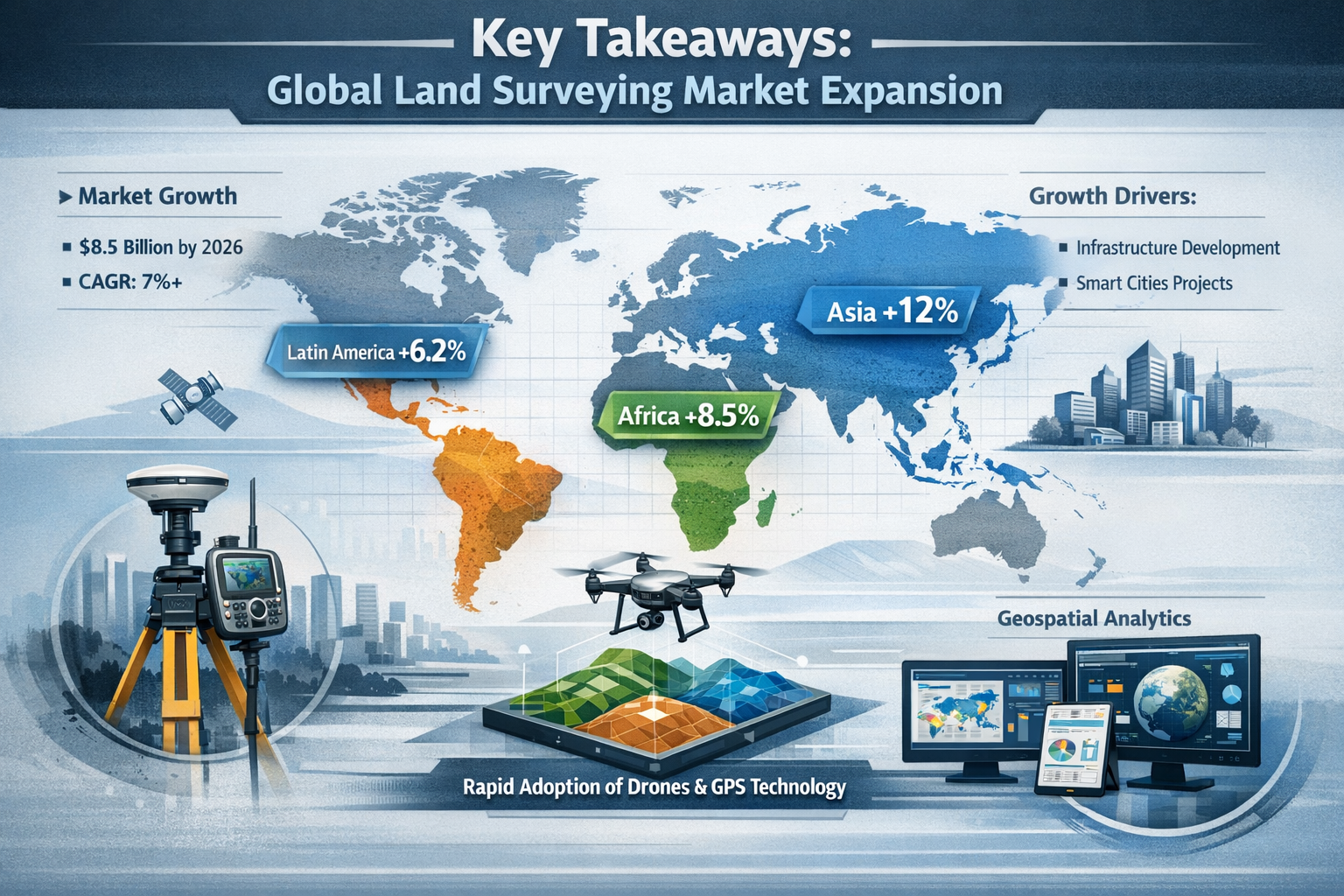
Key Takeaways
- 📈 The global land surveying services market is valued at USD 694.86 million in 2026, with growth to USD 968.47 million expected by 2035, driven primarily by emerging market expansion[2]
- 🌏 Asia-Pacific dominates as the largest regional market with 20% global share, while the Middle East & Africa represents the fastest-growing region at 15% market share[2]
- 🚁 Drone-based surveys increased by 28% year-on-year in 2023, with over 35,000 commercial drones now deployed globally for surveying tasks, revolutionizing data collection methods[2]
- 🇮🇳 India leads regional growth at 11.6% annually, followed by China at 8.7%, fueled by massive infrastructure initiatives and urban development projects[5]
- 💡 Digital transformation is accelerating rapidly, with GIS and BIM adoption increasing by 32% since 2022, and 60-65% of new U.S. projects now employing digital surveying tools[2]
Understanding the Global Land Surveying Market Landscape in 2026
The land surveying industry has evolved dramatically from its traditional roots. Today's market encompasses both surveying services and advanced equipment, creating a comprehensive ecosystem that supports global development initiatives. Understanding this landscape requires examining both market segments and their interconnected growth patterns.
Market Size and Valuation Overview
The surveying industry operates across two primary market segments that work in tandem to deliver accurate land measurement and mapping services:
Land Surveying Services Market:
- Current valuation: USD 694.86 million (2026)[2]
- Projected value: USD 968.47 million by 2035
- Growth trajectory: Steady expansion driven by service demand
Land Survey Equipment Market:
- Current valuation: USD 9.7 billion (2026)[4]
- Projected value: USD 12.47 billion by 2031
- CAGR: 5.17% through 2031[4]
- Extended forecast: USD 13.2 billion by 2036 with 4.2% CAGR[5]
These valuations demonstrate the capital-intensive nature of modern surveying operations, where sophisticated equipment investments enable service delivery at unprecedented scales and accuracy levels.
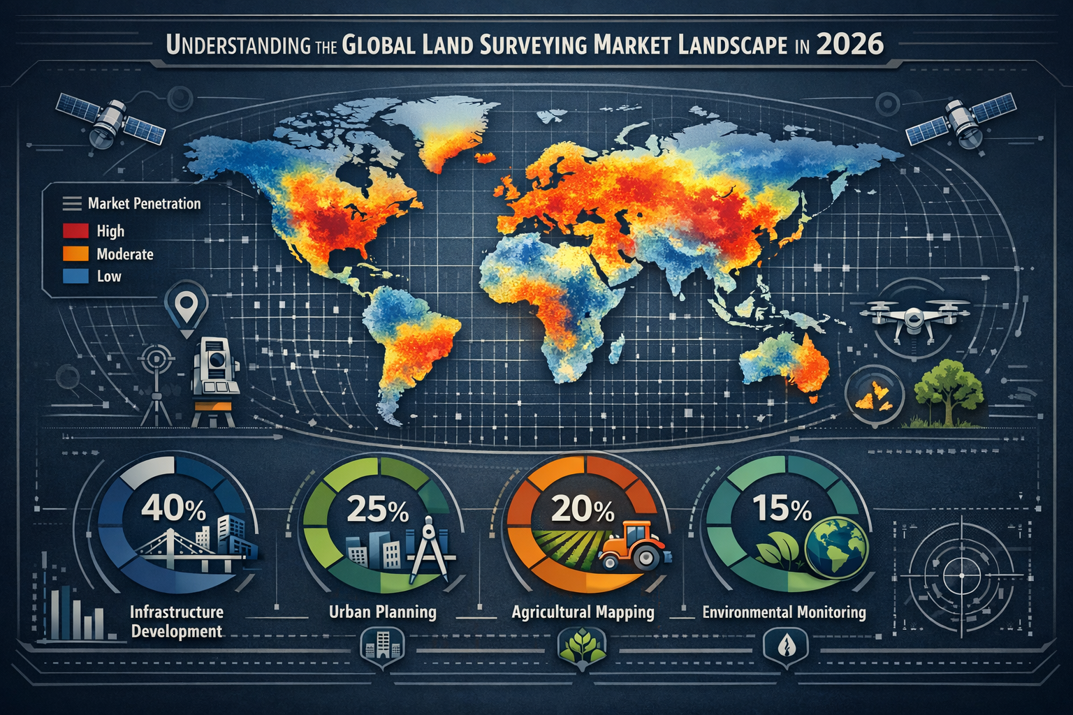
Regional Market Distribution and Dominance
The global surveying market exhibits distinct regional characteristics that reflect varying stages of economic development and infrastructure needs:
| Region | Market Share | Growth Rate | Key Characteristics |
|---|---|---|---|
| North America | ~40% | Moderate | Infrastructure renewal, regulatory compliance[2] |
| Europe | 25% | Steady | Urban regeneration, sustainability projects[2] |
| Asia-Pacific | 20% | Rapid | Urbanization, industrial expansion[2][4] |
| Middle East & Africa | 15% | Fastest | Mega-projects, resource development[2] |
While North America currently dominates with approximately 40% of global market share, the momentum is shifting toward emerging markets. This distribution reflects mature markets maintaining substantial volume while developing regions accelerate their growth trajectories[2].
The Asia-Pacific region, despite holding 20% market share, represents the largest absolute market when considering both services and equipment combined. This apparent contradiction highlights how market share percentages can mask the true scale of regional activity, particularly in populous developing nations[2][4].
The Technology Revolution Reshaping Surveying
Modern land surveying bears little resemblance to the chain-and-compass methods of previous generations. The industry has undergone a digital transformation that's fundamentally changing how professionals collect, process, and deliver spatial data.
Key Technology Adoption Metrics:
🚁 Drone Technology Explosion
- 28% year-on-year increase in drone-based surveys (2023)[2]
- Over 35,000 commercial drones now deployed globally for surveying (up from 25,000 in 2021)[2]
- Reduced survey time by 60-70% for large-scale projects
- Enhanced safety by eliminating hazardous terrain access requirements
💻 Digital Integration Systems
- 32% increase in GIS and BIM adoption since 2022[2]
- 60-65% of new U.S. projects now employ digital surveying tools[2]
- Real-time data integration with construction management systems
- Improved accuracy reducing errors by up to 90%
These technological advances have created a competitive advantage for firms that invest in modern equipment and training. Property inspection methodologies have evolved significantly, incorporating many of these same technological innovations to deliver more comprehensive assessments.
The Global Land Surveying Market Boom: Regional Growth Drivers in Asia
Asia represents the epicenter of the global land surveying market boom, with multiple countries experiencing simultaneous infrastructure explosions that demand sophisticated surveying services. The region's growth story is multifaceted, driven by urbanization, government initiatives, and private sector investment.
India's Leadership Position at 11.6% Annual Growth
India has emerged as the fastest-growing major market for land surveying services, with an impressive 11.6% annual growth rate[5]. This extraordinary expansion reflects several converging factors that create sustained demand for surveying expertise.
Key Growth Drivers in India:
🏗️ Infrastructure Mega-Projects
- National Infrastructure Pipeline: USD 1.4 trillion investment through 2025
- Smart Cities Mission: 100 cities undergoing comprehensive urban transformation
- Bharatmala highway project: 83,677 km of road development
- Dedicated Freight Corridors requiring extensive land surveys
🌆 Rapid Urbanization Patterns
- 600 million people expected in urban areas by 2031
- 40% urbanization rate creating massive housing demand
- New satellite cities requiring comprehensive planning surveys
- Metro rail expansions in 27+ cities
The Indian government's push toward digital land records has further accelerated surveying demand. The Digital India Land Records Modernization Programme (DILRMP) aims to computerize 6.2 lakh villages, creating unprecedented opportunities for surveying professionals equipped with modern technology[5].
China's Steady 8.7% Growth and Belt & Road Impact
While China's growth rate of 8.7% annually appears modest compared to India, the absolute market size makes this expansion enormously significant[5]. China's surveying market benefits from both domestic development and international infrastructure initiatives.
China's Surveying Market Catalysts:
🌐 Belt and Road Initiative (BRI)
- Infrastructure projects across 70+ countries
- Chinese surveying firms expanding internationally
- Technology transfer creating equipment demand
- Cross-border collaboration increasing service exports
🏙️ Domestic Urban Renewal
- 19 megacities with populations exceeding 10 million
- Urban renewal projects in tier-2 and tier-3 cities
- High-speed rail network expansion (40,000 km operational)
- Green building initiatives requiring precise land assessment
China's surveying market also benefits from domestic equipment manufacturing capabilities. Chinese manufacturers now produce competitive surveying equipment at lower price points, making advanced technology accessible to smaller firms and emerging markets[4].
Southeast Asian Expansion and ASEAN Connectivity
The Association of Southeast Asian Nations (ASEAN) represents a collective market of 650 million people experiencing rapid economic development. Infrastructure connectivity projects across the region create substantial surveying demand.
ASEAN Surveying Market Highlights:
- Master Plan on ASEAN Connectivity 2025: Regional infrastructure integration
- Indonesia: New capital city (Nusantara) requiring comprehensive surveying
- Vietnam: Industrial zone expansion and port development
- Thailand: Eastern Economic Corridor infrastructure projects
- Philippines: "Build, Build, Build" program with 75+ major projects
The region's geographic diversity—from island nations to mainland territories—creates unique surveying challenges that drive innovation in building surveyor services and specialized methodologies adapted to tropical environments and varied terrain.
Technology Adoption Patterns Across Asia
Asian markets demonstrate varying technology adoption rates that influence surveying service delivery:
High-Tech Leaders:
- Singapore, South Korea, Japan: Advanced automation, AI integration
- Early adopters of LiDAR and 3D scanning technologies
- Government-mandated BIM requirements driving digital surveying
Rapid Adopters:
- China, India, Malaysia: Fast-growing technology integration
- Drone deployment accelerating rapidly
- Mobile mapping systems gaining traction
Emerging Adopters:
- Vietnam, Indonesia, Philippines: Traditional methods transitioning
- Increasing equipment investment
- Growing demand for training and capacity building
This technology gradient creates opportunities for surveying firms to offer technology transfer services alongside traditional surveying, particularly in markets where local expertise is developing.
The Global Land Surveying Market Boom: Africa's Unprecedented Opportunities
Africa represents the fastest-growing regional market for land surveying services, with the Middle East & Africa collectively accounting for approximately 15% of global market share[2]. The continent's unique combination of resource wealth, urbanization pressures, and infrastructure deficits creates exceptional growth potential for surveying professionals.
Urbanization at Unprecedented Scale
Africa is urbanizing faster than any other continent, with profound implications for land surveying demand. By 2050, Africa's urban population will triple, adding 950 million urban residents—more than the current population of Europe.
African Urbanization Metrics:
📊 Population Dynamics
- Current urban population: 472 million (40% of total)
- Projected 2050 urban population: 1.5 billion (60% of total)
- 24 cities expected to exceed 5 million residents by 2030
- Lagos, Kinshasa, and Cairo approaching 30+ million inhabitants
🏘️ Urban Expansion Patterns
- Horizontal sprawl requiring extensive boundary surveys
- Informal settlements necessitating land tenure formalization
- New planned cities and satellite developments
- Industrial zones and special economic areas
This rapid urbanization creates sustained demand for surveying services across multiple applications, from land boundary disagreement resolution to comprehensive master planning surveys for new developments.
Infrastructure Investment and Development Corridors
African governments and international partners are investing heavily in infrastructure development, creating substantial surveying opportunities across the continent.
Major Infrastructure Initiatives:
🚄 Transportation Networks
- African Union's Programme for Infrastructure Development (PIDA): USD 360 billion investment
- Trans-African Highway network: 56,683 km across the continent
- Railway modernization: Standard Gauge Railways in East Africa
- Port expansions: Lamu, Bagamoyo, and Abidjan mega-ports
⚡ Energy and Utilities
- Grand Ethiopian Renaissance Dam and hydroelectric projects
- Solar and wind farm developments requiring land assessment
- Power transmission corridors across national borders
- Water infrastructure and irrigation schemes
These projects demand comprehensive surveying services, from initial feasibility studies through construction monitoring and final as-built documentation. The cross-border nature of many initiatives creates opportunities for firms with regional capabilities and international standards expertise.
Natural Resource Development and Mining
Africa's abundant natural resources drive significant surveying demand in extractive industries. The continent holds 30% of global mineral reserves, including critical minerals essential for renewable energy technologies.
Resource Sector Surveying Demand:
⛏️ Mining Operations
- Exploration surveys for new deposits
- Mine planning and development surveys
- Tailings management and environmental monitoring
- Reclamation and closure surveys
🛢️ Oil and Gas Development
- Offshore platform positioning and pipeline routes
- Onshore field development and facility surveys
- Environmental baseline assessments
- Infrastructure corridor mapping
The resource sector typically requires high-precision surveying with specialized equipment and expertise, commanding premium rates and creating opportunities for firms with technical capabilities beyond standard construction surveying.
Land Tenure Formalization and Property Rights
One of Africa's most significant surveying opportunities lies in land tenure formalization—the process of documenting and registering property rights that currently exist informally.
Land Tenure Challenges and Opportunities:
📋 Current Situation
- Only 10% of rural African land is formally documented
- 90% of land transactions occur outside formal systems
- Customary land rights lack legal documentation
- Urban informal settlements house 60% of city residents
🎯 Formalization Initiatives
- World Bank Land Administration Projects in 20+ countries
- National cadastral modernization programs
- Community land mapping initiatives
- Digital land registry development
These formalization efforts require massive surveying inputs to establish boundaries, create cadastral maps, and document existing land use patterns. The scale of this work—potentially covering hundreds of millions of parcels—represents a multi-decade opportunity for surveying professionals.
Regional Variation Across Africa
Africa's surveying market exhibits significant regional variation reflecting different development stages and economic structures:
| Sub-Region | Market Characteristics | Primary Drivers |
|---|---|---|
| North Africa | Mature markets, oil/gas focus | Energy projects, urban renewal |
| West Africa | Rapid urbanization, mining | Lagos expansion, resource development |
| East Africa | Infrastructure boom | Regional integration, port development |
| Southern Africa | Mining-dominated, established | Platinum, diamonds, coal operations |
| Central Africa | Emerging opportunities | Resource extraction, conflict recovery |
Understanding these regional nuances enables surveying firms to target specific opportunities aligned with their capabilities and risk tolerance. Property evaluation standards also vary significantly across regions, requiring adaptation to local regulatory frameworks.
The Global Land Surveying Market Boom: Latin America's Emerging Potential
While specific market data for Latin America remains limited in current research, the region represents significant untapped potential within the global land surveying market boom. Latin America's 650 million population, ongoing urbanization, and infrastructure needs create substantial opportunities for surveying professionals.
Infrastructure Deficits Driving Investment
Latin America faces a well-documented infrastructure gap estimated at 2-3% of regional GDP annually. Addressing this deficit requires comprehensive surveying support across multiple sectors.
Infrastructure Investment Areas:
🌉 Transportation Infrastructure
- Road network expansion and rehabilitation
- Urban metro systems in major cities
- Port modernization for Pacific and Atlantic trade
- Airport expansions supporting tourism and commerce
🏗️ Urban Development Projects
- Social housing programs addressing deficits
- Urban renewal in historic city centers
- Smart city initiatives in Brazil, Chile, and Colombia
- Coastal development and tourism infrastructure
The Inter-American Development Bank and other multilateral institutions provide substantial infrastructure financing to the region, with surveying services forming essential components of project preparation and implementation.
Natural Resource and Agricultural Development
Latin America's abundant natural resources and agricultural productivity create specialized surveying demand across rural and remote areas.
Resource Sector Opportunities:
🌾 Agricultural Modernization
- Precision agriculture requiring detailed topographic surveys
- Irrigation system planning and implementation
- Land consolidation and productivity improvements
- Sustainable forestry management
⚡ Renewable Energy Expansion
- Wind farm development in Brazil, Mexico, and Argentina
- Solar installations requiring land assessment
- Hydroelectric projects and reservoir surveys
- Geothermal exploration in volcanic regions
These applications often require surveying in challenging environments—from Amazon rainforest to Andean highlands—demanding specialized equipment and expertise that command premium pricing.
Urbanization and Land Regularization
Latin America is already highly urbanized at 80%, but faces significant challenges with informal settlements and unclear property rights that create surveying opportunities.
Urban Surveying Needs:
🏘️ Informal Settlement Regularization
- Favela mapping and land tenure formalization in Brazil
- Villa upgrading programs in Argentina
- Barrio improvement initiatives across the region
- Community land trust establishment
📍 Cadastral Modernization
- Digital property registry development
- Tax assessment and revenue enhancement
- Property transaction facilitation
- Urban planning data infrastructure
Countries like Colombia have implemented innovative cadastral modernization programs that combine satellite imagery, drone surveys, and community participation to document millions of previously unregistered properties—creating models that other nations are now replicating.
Regional Economic Integration
Latin American economic integration initiatives create cross-border infrastructure projects requiring surveying expertise:
Integration Projects:
- IIRSA (Initiative for the Integration of Regional Infrastructure in South America): 562 projects across 10 countries
- Pacific Alliance infrastructure connectivity
- Central American Integration System transportation corridors
- Amazon Cooperation Treaty sustainable development projects
These regional initiatives often involve international surveying standards and cross-border coordination, creating opportunities for firms with multi-country capabilities and experience navigating different regulatory environments.
Technology Adoption and Digital Transformation
Latin American surveying markets show increasing technology adoption, though at varying rates across countries:
Technology Leaders:
- Chile: Advanced mining sector drives high-tech surveying
- Brazil: Large-scale agriculture adopting precision technologies
- Mexico: Manufacturing sector integration with North American standards
Emerging Markets:
- Central America: Growing drone adoption for infrastructure
- Andean nations: Mining driving specialized equipment investment
- Caribbean: Tourism development creating surveying demand
The region's technology adoption creates opportunities for equipment suppliers and firms offering training and capacity building alongside traditional surveying services, similar to approaches used in property survey template development and standardization.
Technology as the Great Enabler of Market Expansion
The Global Land Surveying Market Boom: Growth Drivers in Asia, Africa, and Latin America would be impossible without the technological revolution transforming how surveying services are delivered. Modern technology enables firms to operate at scales and speeds unimaginable a decade ago.
Drone Technology and Aerial Surveying
The explosive growth in drone-based surveying represents perhaps the single most transformative technology in the industry. With a 28% year-on-year increase in 2023 alone, drones have moved from novelty to necessity[2].
Drone Surveying Advantages:
✈️ Operational Benefits
- 60-70% time reduction for large-area surveys
- Access to hazardous or inaccessible terrain
- Minimal ground disturbance and environmental impact
- Rapid deployment for emergency response
📊 Data Quality Improvements
- High-resolution imagery (sub-centimeter accuracy)
- 3D terrain modeling and volumetric calculations
- Multispectral data for vegetation and land use analysis
- Repeatable flights for change detection monitoring
The global fleet of 35,000+ commercial surveying drones (up from 25,000 in 2021) demonstrates the technology's rapid adoption[2]. Emerging markets particularly benefit from drones' ability to survey large areas quickly without extensive ground infrastructure.
Geographic Information Systems (GIS) and Data Integration
GIS technology adoption increased by 32% since 2022, reflecting the industry's shift toward integrated spatial data management[2]. Modern surveying increasingly delivers not just measurements but comprehensive spatial intelligence.
GIS Integration Benefits:
🗺️ Enhanced Data Utility
- Multi-layer spatial analysis capabilities
- Integration with planning and engineering systems
- Real-time data sharing with stakeholders
- Historical data comparison and trend analysis
💼 Business Value Creation
- Expanded service offerings beyond traditional surveying
- Recurring revenue from data management services
- Value-added analysis and consulting opportunities
- Integration with client decision-making processes
The shift toward GIS-integrated surveying aligns with broader digital transformation trends, similar to how condition survey London practices have evolved to incorporate comprehensive data management.
Building Information Modeling (BIM) Integration
BIM has transformed construction project delivery, with surveying playing a crucial role in providing accurate as-built data and site verification throughout project lifecycles.
BIM-Surveying Integration:
🏗️ Project Lifecycle Support
- Pre-construction site surveys feeding BIM models
- Construction progress monitoring and verification
- Clash detection between design and existing conditions
- As-built documentation for facility management
📈 Market Impact
- 60-65% of new U.S. projects now employ digital surveying tools integrated with BIM[2]
- Government mandates in UK, Singapore, and other markets driving adoption
- Enhanced accuracy reducing costly construction errors
- Improved collaboration across project teams
This integration creates opportunities for surveying firms to position themselves as technology partners rather than commodity service providers, commanding higher margins and building long-term client relationships.
Mobile Mapping and LiDAR Technology
Mobile mapping systems combining LiDAR (Light Detection and Ranging) with GPS and imaging sensors enable rapid corridor mapping for transportation and utility projects.
Mobile Mapping Applications:
🚗 Transportation Projects
- Highway and railway corridor surveys
- Pavement condition assessment
- Asset inventory and management
- Clearance verification for utilities
🌆 Urban Environments
- Streetscape documentation
- Utility mapping and conflict detection
- Smart city digital twin creation
- Heritage preservation documentation
The technology's ability to capture millions of data points per second while moving at highway speeds makes it ideal for linear infrastructure projects common in developing markets.
Artificial Intelligence and Machine Learning
AI and machine learning are beginning to transform surveying data processing, automating tasks that previously required extensive manual effort.
AI Applications in Surveying:
🤖 Automated Processing
- Feature extraction from imagery and point clouds
- Automated classification of land cover types
- Change detection and anomaly identification
- Quality control and error detection
📊 Predictive Analytics
- Settlement prediction for construction monitoring
- Deformation analysis for infrastructure assets
- Optimal survey planning and resource allocation
- Cost estimation and project scheduling
While AI adoption remains in early stages, forward-thinking firms are investing in these capabilities to maintain competitive advantages as the technology matures.
Challenges and Barriers to Market Expansion
Despite extraordinary growth opportunities, the Global Land Surveying Market Boom: Growth Drivers in Asia, Africa, and Latin America faces significant challenges that firms must navigate to succeed in these markets.
Skills Shortages and Capacity Constraints
The surveying industry globally faces a critical skills shortage that's particularly acute in emerging markets experiencing rapid growth.
Workforce Challenges:
👥 Demographic Issues
- Aging workforce in developed markets
- Insufficient training capacity in emerging markets
- Competition from related professions (engineering, GIS)
- Brain drain from developing to developed countries
📚 Education and Training Gaps
- Limited surveying programs in many African and Latin American countries
- Outdated curricula not reflecting modern technology
- Insufficient practical training opportunities
- Lack of continuing education for technology updates
Addressing these challenges requires strategic workforce development investments, including partnerships with educational institutions, internal training programs, and technology that enables less-experienced staff to perform complex tasks with appropriate supervision.
Regulatory and Licensing Complexity
Operating across multiple countries requires navigating diverse regulatory frameworks, licensing requirements, and professional standards.
Regulatory Challenges:
⚖️ Licensing Variations
- Different professional qualification requirements
- Reciprocity limitations between countries
- Local practice restrictions favoring domestic firms
- Varying liability and insurance requirements
📋 Technical Standards
- Differing accuracy requirements and specifications
- Incompatible coordinate systems and datums
- Varied documentation and deliverable formats
- Conflicting environmental and safety regulations
Successful firms develop regulatory expertise as a competitive advantage, often partnering with local firms to navigate complex requirements while maintaining quality standards. Understanding legal requirements becomes essential for international expansion.
Technology Investment Requirements
Modern surveying demands substantial capital investment in equipment and software that creates barriers to entry, particularly for firms in emerging markets.
Investment Challenges:
💰 Capital Requirements
- High-end surveying equipment: USD 50,000-200,000 per unit
- Drone systems with processing software: USD 15,000-100,000
- Mobile mapping systems: USD 200,000-500,000+
- Software licenses and annual subscriptions
🔧 Ongoing Costs
- Equipment maintenance and calibration
- Technology upgrades and obsolescence
- Training and certification expenses
- Data storage and processing infrastructure
These investment requirements favor larger firms with access to capital, though equipment financing and rental models are emerging to democratize access to advanced technology.
Political and Economic Instability
Many high-growth markets face political uncertainty and economic volatility that create business risks.
Risk Factors:
🌍 Political Challenges
- Government instability affecting project continuity
- Corruption and procurement irregularities
- Expropriation risks for foreign firms
- Regulatory unpredictability
💱 Economic Volatility
- Currency fluctuations affecting profitability
- Payment delays and default risks
- Inflation eroding project margins
- Capital controls limiting fund repatriation
Managing these risks requires sophisticated risk assessment and mitigation strategies, including appropriate contract structures, insurance coverage, and diversification across multiple markets and client types.
Infrastructure and Logistics Constraints
Operating in emerging markets often means working with limited infrastructure that complicates project execution.
Operational Challenges:
🚧 Physical Infrastructure
- Poor road access to project sites
- Unreliable power supply affecting equipment
- Limited telecommunications for data transfer
- Security concerns in remote areas
📦 Logistics Issues
- Equipment import restrictions and delays
- Spare parts availability and support
- Calibration and repair service access
- Data transfer bandwidth limitations
These constraints require operational adaptability and contingency planning that experienced firms build into project schedules and budgets, similar to considerations in property survey expenses planning.
Strategic Approaches for Market Entry and Expansion
Successfully capitalizing on the Global Land Surveying Market Boom: Growth Drivers in Asia, Africa, and Latin America requires thoughtful strategy that balances opportunity with risk management.
Partnership and Joint Venture Models
Strategic partnerships with local firms offer the fastest path to market entry while mitigating regulatory and operational risks.
Partnership Strategies:
🤝 Local Firm Collaboration
- Joint ventures combining international expertise with local knowledge
- Subcontracting arrangements for specific capabilities
- Technology transfer agreements
- Training and capacity building partnerships
Benefits:
- Immediate local market access and relationships
- Regulatory compliance and licensing facilitation
- Cultural understanding and language capabilities
- Risk sharing and reduced capital requirements
Challenges:
- Partner selection and due diligence
- Intellectual property protection
- Quality control and standards maintenance
- Profit sharing and governance structures
Successful partnerships require clear agreements defining roles, responsibilities, quality standards, and exit provisions, with ongoing relationship management to ensure alignment.
Technology-Led Differentiation
Firms can differentiate themselves in emerging markets through superior technology and capabilities that local competitors cannot easily replicate.
Technology Strategies:
🔬 Advanced Capabilities
- Specialized equipment for challenging environments
- Proprietary processing methodologies
- Integrated service offerings (surveying + GIS + BIM)
- Rapid mobilization and delivery capabilities
Market Positioning:
- Premium pricing for superior accuracy and speed
- Value-added services beyond basic surveying
- Technology demonstration and education
- Thought leadership and standards development
This approach works particularly well for complex projects where accuracy, speed, or specialized expertise justify premium pricing, though it requires ongoing investment to maintain technological advantages.
Sector Specialization
Focusing on specific industry sectors enables firms to develop deep expertise that creates competitive advantages.
Sector Focus Options:
⛏️ Natural Resources
- Mining and exploration surveying
- Oil and gas development
- Renewable energy projects
- Environmental monitoring
🏗️ Infrastructure
- Transportation corridor surveys
- Utility mapping and design
- Water resources and irrigation
- Urban development projects
🏘️ Land Administration
- Cadastral surveying and mapping
- Land tenure formalization
- Property boundary determination
- Geographic information system development
Sector specialization enables firms to develop repeatable methodologies, build specialized equipment inventories, and establish industry relationships that generate recurring business and referrals.
Capacity Building and Local Development
Forward-thinking firms invest in local capacity development as both a market entry strategy and corporate social responsibility initiative.
Capacity Building Approaches:
📚 Education and Training
- University partnerships and curriculum development
- Internship and graduate recruitment programs
- Technical training for local professionals
- Equipment operation and maintenance training
🌱 Local Firm Development
- Subcontractor development programs
- Equipment leasing or financing support
- Quality management system implementation
- Technology transfer and knowledge sharing
These investments create sustainable local presence while building goodwill with governments and communities, often leading to preferential consideration for public sector projects and development partner initiatives.
Geographic Diversification
Rather than concentrating in single markets, successful firms often pursue regional strategies that spread risk across multiple countries.
Diversification Benefits:
- Reduced exposure to country-specific political and economic risks
- Ability to shift resources to highest-value opportunities
- Economies of scale in regional equipment and personnel deployment
- Enhanced credibility with multinational clients and development partners
Implementation Approaches:
- Regional hub-and-spoke models
- Mobile teams serving multiple countries
- Shared services and support functions
- Standardized systems adapted to local requirements
This approach requires sophisticated management to coordinate across borders while maintaining quality and efficiency, but provides resilience against market-specific disruptions.
Future Outlook: The Next Decade of Growth
The Global Land Surveying Market Boom: Growth Drivers in Asia, Africa, and Latin America shows no signs of slowing, with multiple trends suggesting sustained growth through 2035 and beyond.
Market Projections and Growth Trajectories
Current market forecasts indicate robust expansion across all segments and regions through the next decade.
Projected Market Growth:
📈 Services Market
- 2026: USD 694.86 million[2]
- 2035: USD 968.47 million
- CAGR: ~3.8% annually
- Growth driver: Emerging market demand expansion
📊 Equipment Market
- 2026: USD 9.7 billion[4]
- 2031: USD 12.47 billion
- 2036: USD 13.2 billion[5]
- CAGR: 4.2-5.17% annually
These projections assume continued urbanization, infrastructure investment, and technology adoption in emerging markets, with Asia, Africa, and Latin America contributing disproportionately to incremental growth.
Emerging Technology Trends
Several technology trends will shape surveying service delivery over the next decade:
🚀 Next-Generation Technologies:
Autonomous Systems
- Self-operating surveying robots for repetitive tasks
- Autonomous drone swarms for large-area mapping
- AI-driven data processing and analysis
- Automated quality control and verification
Quantum Positioning
- Quantum sensors for ultra-precise measurements
- Independence from satellite-based positioning
- Enhanced accuracy in challenging environments
- New applications in deformation monitoring
Digital Twin Integration
- Real-time surveying data feeding digital city models
- Continuous monitoring and updating
- Predictive analytics for infrastructure management
- Integration with IoT sensor networks
Augmented Reality
- Field visualization of design overlays
- Real-time stake-out and verification
- Enhanced client communication and understanding
- Training and education applications
Firms investing early in these emerging technologies will establish competitive advantages as they mature and become commercially viable.
Sustainability and Climate Change Impacts
Climate change and sustainability concerns are creating new surveying applications while transforming existing ones.
Climate-Related Opportunities:
🌍 Adaptation and Resilience
- Coastal zone mapping for sea-level rise planning
- Flood risk assessment and modeling
- Infrastructure vulnerability analysis
- Relocation and retreat planning surveys
♻️ Sustainability Projects
- Renewable energy site assessment and monitoring
- Carbon sequestration measurement (forestry, agriculture)
- Wetland restoration and monitoring
- Green infrastructure planning and verification
Environmental Monitoring
- Deforestation tracking and enforcement
- Biodiversity habitat mapping
- Water resource management
- Climate impact assessment
These applications often involve long-term monitoring relationships that provide recurring revenue and deeper client relationships, moving beyond transactional project-based work.
Evolving Business Models
The surveying industry is experimenting with new business models that leverage technology and data to create value beyond traditional fee-for-service arrangements.
Innovative Business Models:
💡 Subscription Services
- Continuous monitoring and updating
- Data-as-a-service platforms
- Software and analytics subscriptions
- Managed services for asset owners
📊 Outcome-Based Pricing
- Value-based fees tied to project outcomes
- Risk-sharing arrangements
- Performance guarantees
- Equity participation in developments
🤝 Platform Models
- Marketplaces connecting surveyors with clients
- Crowdsourced data collection and validation
- Open data platforms with premium services
- Collaborative industry platforms
These models require different capabilities than traditional surveying, including software development, data science, and business model innovation, but offer potential for higher margins and more defensible competitive positions.
Policy and Regulatory Evolution
Government policies and regulations will significantly influence market development over the next decade.
Policy Trends:
📋 Digital Transformation Mandates
- BIM requirements for public projects
- Digital land registry initiatives
- Open data and transparency requirements
- Interoperability standards
🌱 Sustainability Regulations
- Environmental impact assessment requirements
- Climate risk disclosure mandates
- Green building certification
- Natural resource management regulations
🏘️ Land Governance Reforms
- Property rights formalization programs
- Cadastral modernization initiatives
- Spatial planning framework development
- Infrastructure planning requirements
Firms that actively engage in policy development and standards-setting can shape regulatory environments to favor their capabilities and business models while contributing to improved industry practices.
Conclusion: Seizing the Global Opportunity
The Global Land Surveying Market Boom: Growth Drivers in Asia, Africa, and Latin America represents a once-in-a-generation opportunity for surveying professionals and firms willing to embrace change and expand beyond traditional markets. With the services market growing from USD 694.86 million in 2026 to nearly USD 1 billion by 2035, and the equipment market expanding from USD 9.7 billion to over USD 13 billion, the scale of opportunity is unprecedented[2][4][5].
Key success factors for capitalizing on this boom include:
✅ Technology Investment: Embracing drones, GIS, BIM, and emerging technologies that enable competitive service delivery
✅ Strategic Partnerships: Collaborating with local firms to navigate regulatory requirements and cultural contexts
✅ Workforce Development: Investing in training and capacity building to address critical skills shortages
✅ Sector Specialization: Developing deep expertise in high-value sectors like infrastructure, resources, or land administration
✅ Risk Management: Implementing sophisticated approaches to political, economic, and operational risks in emerging markets
The 57% of surveying firms planning expansion into high-growth regions demonstrate industry recognition of these opportunities. Those who move decisively while managing risks prudently will establish positions in markets that will drive industry growth for decades to come.
For surveying professionals, this boom creates career opportunities in international work, technology specialization, and leadership roles in expanding organizations. For firms, it offers growth trajectories far exceeding mature market possibilities. For equipment manufacturers and technology providers, it represents expanding markets for innovation.
Actionable Next Steps
Organizations and professionals seeking to participate in this market boom should consider these concrete actions:
For Surveying Firms:
- Conduct market assessment: Evaluate specific countries and sectors aligned with your capabilities
- Develop technology roadmap: Plan investments in equipment and software to remain competitive
- Identify partnership opportunities: Research potential local partners in target markets
- Build international capabilities: Develop expertise in cross-border operations and regulations
- Start small and scale: Begin with pilot projects to learn before major commitments
For Individual Professionals:
- Acquire technology skills: Gain proficiency in drones, GIS, BIM, and data processing
- Develop language capabilities: Learn languages relevant to target regions
- Build cultural competence: Study business practices and customs in emerging markets
- Pursue specialized certifications: Obtain credentials in high-demand specializations
- Network internationally: Connect with professionals in target markets
For Educational Institutions:
- Modernize curricula: Incorporate current technology and international perspectives
- Develop partnerships: Collaborate with institutions in emerging markets
- Create practical opportunities: Provide internships and project-based learning
- Address capacity gaps: Expand programs to meet growing workforce demand
- Support continuing education: Offer professional development for practicing surveyors
The global land surveying market boom is not a temporary phenomenon but a structural shift driven by urbanization, infrastructure needs, and technological transformation that will reshape the industry for decades. Those who recognize this shift and position themselves strategically will thrive in an expanding global market, while those who remain focused solely on mature markets may find themselves increasingly marginalized.
The opportunity is clear, the drivers are strong, and the time to act is now. Whether through property evaluation expertise, specialized building surveyor capabilities, or comprehensive real estate assessment services, professionals who embrace the global opportunity will define the future of land surveying.
References
[1] Global Land Surveying Services Forecast 43669571 – https://www.marketresearch.com/APO-Research-Inc-v4273/Global-Land-Surveying-Services-Forecast-43669571/
[2] Land Surveying Market 111958 – https://www.marketgrowthreports.com/market-reports/land-surveying-market-111958
[3] Land Survey Equipment Market – https://www.skyquestt.com/report/land-survey-equipment-market
[4] Land Survey Equipment Market – https://www.mordorintelligence.com/industry-reports/land-survey-equipment-market
[5] Land Survey Equipment Market – https://www.futuremarketinsights.com/reports/land-survey-equipment-market
[6] Future Land Surveying 2026 – https://haller-blanchard.com/future-land-surveying-2026/
[7] Land Surveying Market Report – https://www.cognitivemarketresearch.com/land-surveying-market-report