
The surveying industry has reached a tipping point. What once required teams of professionals, weeks of fieldwork, and budgets stretching into tens of thousands of dollars can now be accomplished by a single operator with a drone in a matter of hours—often at a fraction of the cost. Drone Surveying in 2026: Cost Savings, Accuracy Improvements, and Practical Implementation represents not just an evolution but a revolution in how surveying firms, construction companies, and property professionals gather spatial data.
In 2026, drone technology has matured beyond the early-adopter phase. The barriers that once kept smaller firms on the sidelines—prohibitive costs, complex processing workflows, and steep learning curves—have largely disappeared. Today's drone surveying platforms deliver sub-5cm precision, process data with minimal human intervention, and produce deliverables within hours of flight completion.[1] This transformation has democratized access to survey-grade accuracy, enabling firms of all sizes to compete on technical merit rather than equipment budgets.
The implications extend far beyond simple cost reduction. Drone surveying has fundamentally changed project timelines, risk management strategies, and the very nature of how professionals approach spatial data collection. From monitoring construction milestones to documenting property conditions, the technology has become so integral that its absence is now questioned rather than its presence.[1]
Key Takeaways
- 💰 Cost reductions of 60-80% compared to traditional surveying methods make drone technology accessible to firms of all sizes
- 🎯 Sub-5cm RTK precision delivers survey-grade accuracy suitable for construction verification, earthwork calculations, and regulatory compliance
- ⚡ Processing times cut from days to hours through push-button automation and AI-powered data interpretation
- 🔄 Periodic monitoring becomes economically viable, enabling project lifecycle tracking that was previously cost-prohibitive
- 🚀 GPS-denied sensor technology opens new applications in tunnels, mines, and interior spaces where traditional drones cannot operate
Understanding the Cost Revolution in Drone Surveying
The Traditional Surveying Cost Burden
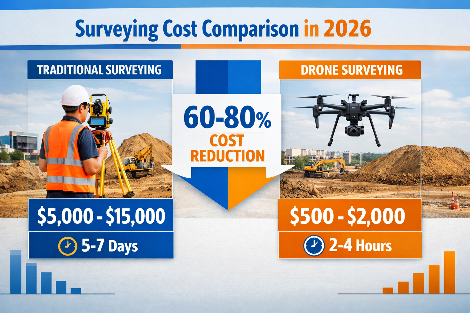
Traditional ground-based surveying has long represented a significant expense for construction projects, property assessments, and land development initiatives. A typical topographic survey using conventional methods requires multiple personnel, specialized equipment, and several days of fieldwork. Costs for traditional surveys routinely range from $5,000 to $15,000 for medium-sized sites, with larger or more complex projects escalating into six-figure territory.
These expenses compound when projects require periodic monitoring. Construction sites need regular surveys to verify earthwork volumes, track progress, and ensure compliance with design specifications. Under traditional approaches, the cost of frequent surveys becomes prohibitive, forcing project managers to limit data collection to critical milestones only—leaving gaps in documentation that can lead to costly disputes or rework.
How Drone Surveying Reduces Operational Costs
The economics of drone surveying fundamentally differ from traditional methods. A single operator with a RTK-enabled drone can capture comprehensive site data in 2-4 hours, compared to the 5-7 days typically required for ground crews.[1] This dramatic reduction in field time translates directly to labor cost savings, often representing the largest component of total surveying expenses.
Equipment costs have also decreased substantially. While professional-grade RTK drones represented significant capital investments just a few years ago, 2026 models offer survey-grade accuracy at price points accessible to small and medium-sized firms. The total cost for a drone survey now typically ranges from $500 to $2,000 for sites that would have cost $5,000-$15,000 using traditional methods—a reduction of 60-80%.[3]
Beyond direct costs, drone surveying eliminates many hidden expenses:
- Reduced site disruption: Aerial data collection doesn't interfere with ongoing construction activities
- Improved safety: Fewer personnel exposed to hazardous site conditions
- Faster turnaround: Compressed timelines reduce project delays and associated costs
- Minimal mobilization: Single operator deployment versus multi-person survey crews
Making Periodic Monitoring Economically Viable
Perhaps the most transformative cost benefit lies in what drone surveying makes newly affordable: regular, comprehensive site monitoring. Projects that previously received surveys at 2-3 critical milestones can now be monitored weekly or even daily without budget strain.[1]
This capability fundamentally changes project management dynamics. Construction managers can track earthwork progress continuously, identify discrepancies before they become costly problems, and maintain complete documentation throughout the project lifecycle. The Halawa View Apartments project in Hawaii exemplified this new standard, where drone mapping became so routine that missing a scheduled scan raised internal questions—a complete reversal from viewing surveys as expensive, occasional events.[1]
For property surveyors and chartered surveyors, this economic shift enables more comprehensive condition survey reports that incorporate detailed aerial documentation at costs that remain competitive with traditional approaches.
Cost Comparison Table: Drone vs. Traditional Surveying
| Factor | Traditional Surveying | Drone Surveying (2026) | Savings |
|---|---|---|---|
| Field Time | 5-7 days | 2-4 hours | 90%+ reduction |
| Personnel Required | 3-5 crew members | 1 operator | 70-80% reduction |
| Typical Project Cost | $5,000-$15,000 | $500-$2,000 | 60-80% reduction |
| Site Disruption | Significant | Minimal | Productivity gains |
| Processing Time | 3-5 days | 2-6 hours | 85%+ reduction |
| Monitoring Frequency | 2-3 times/project | Weekly or daily | Unlimited improvement |
Accuracy Improvements: From Adequate to Survey-Grade Precision
The Evolution to Sub-5cm RTK Accuracy
Accuracy has been the critical battleground for drone surveying acceptance among professional surveyors. Early drone mapping systems struggled with precision, often delivering results suitable for visualization but inadequate for engineering applications. The landscape in 2026 looks dramatically different.
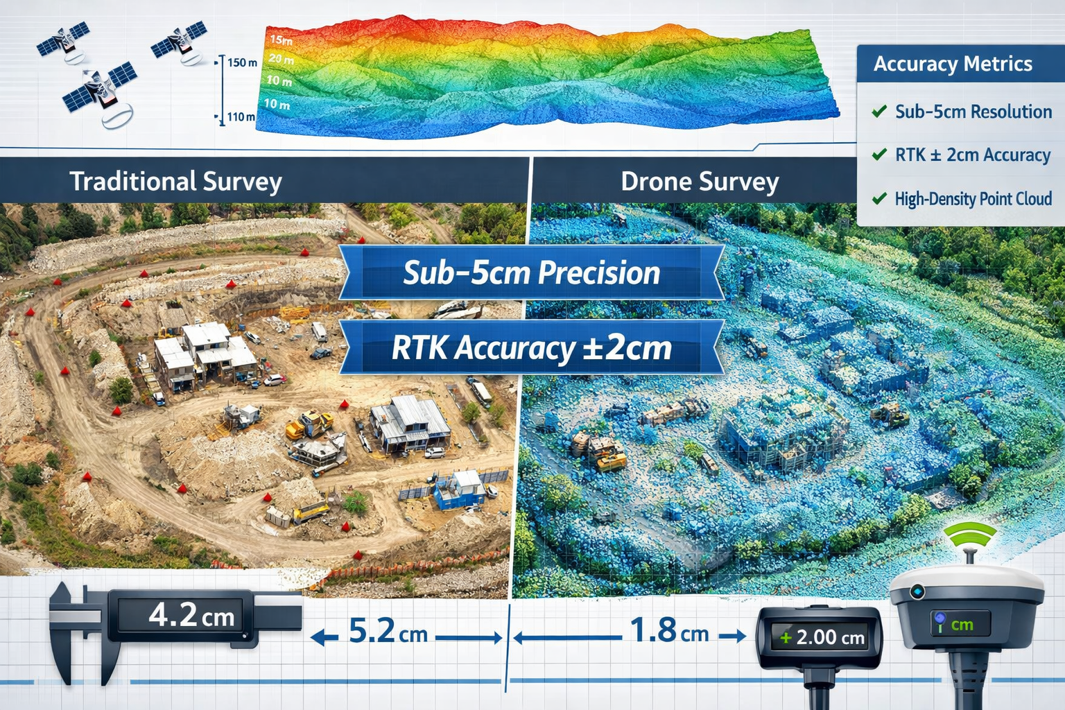
Real-Time Kinematic (RTK) positioning has become standard on professional drone surveying platforms, delivering sub-5cm horizontal and vertical precision—accuracy levels that meet or exceed requirements for most construction and engineering applications.[1] This precision is essential for verifying earthwork volumes, confirming slab elevations, and validating utility placement in construction environments.
The technical foundation for this accuracy lies in several converging technologies:
- RTK/PPK GNSS integration: Direct georeferencing eliminates or minimizes ground control point requirements
- Advanced sensor calibration: Out-of-the-box camera calibration for newer sensors reduces systematic errors[2]
- Improved IMU systems: Better inertial measurement units enhance positioning during GNSS signal interruptions
- Sensor fusion: Combining multiple data sources improves overall accuracy and reliability[4]
Orthomosaic Maps and Centimeter-Level Measurements
The deliverables from modern drone surveying systems demonstrate accuracy that would have been unthinkable from aerial platforms a decade ago. Orthomosaic maps—composite images corrected for lens distortion, camera tilt, and terrain variation—now provide uniform scale across entire project sites, enabling accurate distance and area calculations directly from imagery.[1]
This orthorectification process transforms raw aerial photographs into measurement-grade documents. Surveyors can extract dimensions, calculate areas, and measure distances with centimeter-level confidence—capabilities that make drone-derived orthomosaics suitable for regulatory submissions, design verification, and legal documentation.
Point cloud data from photogrammetry or LiDAR sensors provides three-dimensional accuracy that rivals terrestrial laser scanning. Modern processing algorithms generate millions of precisely positioned points, creating detailed digital elevation models that capture subtle terrain variations critical for drainage design, cut-fill calculations, and grading verification.
GPS-Denied Environments: Expanding Accuracy Beyond Open Skies
One of the most significant accuracy breakthroughs in 2026 involves GPS-denied sensor technology that enables drone surveying in environments where satellite positioning is unavailable or unreliable.[4] This capability opens entirely new application areas that were previously inaccessible to drone platforms:
- 🏗️ Bridge inspections: Interior and underside documentation without GPS signals
- 🚇 Tunnel surveying: Complete as-built documentation in subterranean environments
- 🏭 Industrial facilities: Interior plant surveys and confined space mapping
- ⛏️ Underground mining: Drift and stope surveys without surface GNSS reference
These GPS-denied sensors rely on visual-inertial odometry, LiDAR SLAM (Simultaneous Localization and Mapping), and other advanced positioning techniques that maintain accuracy through sensor fusion and algorithmic processing rather than satellite signals. The result is survey-grade data collection in spaces that previously required manual measurement or expensive specialized equipment.
Validation and Quality Assurance in 2026
Professional surveying standards demand rigorous quality control, and 2026 drone surveying workflows incorporate multiple validation mechanisms:
Automated accuracy reporting built into processing software flags potential issues before deliverables reach clients. Systems analyze tie-point distributions, calculate root-mean-square errors, and identify areas of uncertainty—providing transparency that builds confidence in drone-derived data.
Ground control point verification remains important for critical applications, but the number of points required has decreased dramatically with RTK/PPK systems. Where early drone mapping might have required 10-15 ground control points for a small site, modern RTK workflows often need only 2-3 checkpoints for validation purposes.
This combination of improved sensor accuracy, advanced processing algorithms, and robust quality control has elevated drone surveying from a "good enough" alternative to a preferred method for many applications—particularly when structural survey requirements demand comprehensive documentation.
Practical Implementation: Making Drone Surveying Work for Your Firm
The 2026 Roadmap: Fast Results, Survey-Grade Accuracy, Minimal Intervention
Industry leaders have identified three core requirements that define successful drone surveying implementation in 2026: fast results, survey-grade accuracy, and minimal operator intervention.[2] These aren't aspirational goals but mandatory capabilities that clients now expect as standard.
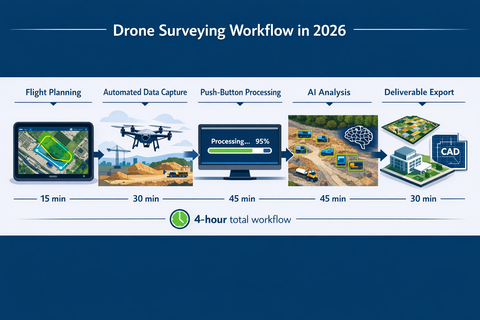
Processing speed has become non-negotiable. Defense organizations, emergency response agencies, national mapping agencies, and surveying firms demand finished, actionable mapping products within hours of the final photo being captured. Multi-day processing workflows are considered obsolete.[2] This urgency reflects the reality that data loses value with time—construction decisions happen in hours, not days.
The accuracy requirement has been addressed through RTK integration and improved sensors, as discussed previously. The third pillar—minimal operator intervention—represents the current development frontier.
Push-Button Automation and Workflow Simplification
The complexity that plagued early drone surveying systems has given way to push-button automation that requires minimal specialized training.[2] Modern platforms implement:
- ✅ Fully automatic project tiling: Software intelligently divides large sites into manageable processing chunks
- ✅ Distributed processing: Cloud-based systems leverage remote computing power to accelerate deliverable generation
- ✅ Out-of-the-box camera calibration: Pre-calibrated sensor profiles eliminate manual calibration workflows
- ✅ Automated ground control detection: Targets are identified and measured automatically from imagery
- ✅ AI-powered quality control: Algorithms flag potential issues before human review
This automation has cut documentation time in half compared to traditional methods, while simultaneously reducing the skill level required to operate systems effectively.[1] Firms can train new operators in weeks rather than months, and experienced personnel can focus on interpretation and client service rather than technical processing tasks.
AI-Powered Data Interpretation and Object Recognition
Perhaps the most transformative practical improvement in 2026 involves AI-powered automated data interpretation.[4] Modern drone surveying platforms incorporate machine learning algorithms that:
- 🔍 Identify objects automatically: Buildings, vehicles, vegetation, utilities, and infrastructure
- 🚨 Detect defects: Cracks, spalling, corrosion, and other condition issues
- 📊 Recognize patterns: Change detection between survey epochs
- 🗂️ Perform automated classification: Point cloud segmentation into ground, vegetation, buildings, etc.
- 📈 Generate analytics: Volume calculations, progress tracking, and compliance reporting
These capabilities eliminate days of manual processing work that previously consumed significant portions of project budgets. What once required skilled technicians reviewing imagery point-by-point now happens automatically, with human operators reviewing and validating AI-generated results rather than creating them from scratch.
For property surveyors conducting comprehensive assessments, AI-powered analysis can identify potential issues—from roof damage to drainage problems—that might be missed in manual review, enhancing the thoroughness of building surveys and condition reports.
Sensor Fusion and Multi-Modal Data Collection
Sensor fusion—combining data from multiple sensor types—has become standard practice across construction, forestry, and utility companies in 2026.[4] Rather than choosing between photogrammetry, LiDAR, thermal imaging, or multispectral sensors, firms increasingly deploy platforms that integrate multiple sensors simultaneously.
This multi-modal approach provides complementary data that addresses different analytical needs:
- RGB imagery: High-resolution visual documentation and photogrammetric modeling
- LiDAR: Penetration through vegetation and precise elevation data
- Thermal imaging: Heat loss detection, moisture identification, electrical hotspot location
- Multispectral sensors: Vegetation health, drainage analysis, material differentiation
Sensor fusion reduces post-flight data cleanup time and improves integration with other technologies, creating comprehensive datasets that support diverse analytical requirements from a single flight mission.
Building Drone Surveying into Standard Workflows
The maturity of drone surveying technology in 2026 enables integration into standard project workflows rather than treating it as a special-purpose tool. Construction projects now standardize drone monitoring as part of their workflows, scheduling regular flights as routine project activities.[1]
Successful implementation follows several best practices:
1. Define clear deliverable requirements: Specify accuracy needs, output formats, and turnaround times upfront
2. Establish regular flight schedules: Weekly or bi-weekly monitoring for active construction, monthly for maintenance applications
3. Integrate with existing software: Ensure drone data flows into CAD, BIM, GIS, and project management platforms
4. Train multiple operators: Avoid single-person dependencies that create bottlenecks
5. Develop standard operating procedures: Document flight planning, data processing, quality control, and delivery workflows
6. Maintain regulatory compliance: Stay current with FAA regulations and local operating restrictions[8]
For firms providing property condition assessments, integrating drone surveying into standard service offerings enhances report quality while maintaining competitive pricing—particularly valuable when preparing comprehensive documentation for property purchase decisions.
Regulatory Considerations for 2026
The regulatory landscape continues evolving. The June 2025 Trump administration executive order "Unleashing American Drone Dominance" initiated regulatory changes aimed at jumpstarting the industry, with a proposed ban on foreign-made drones intended to affect 2026 operations.[5] While implementation details remain uncertain, surveying firms should monitor developments that may impact equipment procurement and operational procedures.
The FAA has stepped up enforcement in 2025, emphasizing proper registration, airspace authorization, and remote identification compliance.[8] Professional surveying firms must maintain rigorous regulatory compliance to avoid operational disruptions and liability exposure.
Real-World Applications Across Industries
Construction and Civil Engineering
Construction represents the largest and most mature application area for drone surveying in 2026. Projects of all sizes now incorporate aerial data collection for:
- Site preparation verification: Confirming clearing, grubbing, and rough grading before foundation work
- Earthwork volume calculations: Measuring cut and fill quantities for progress billing and material management
- Progress documentation: Creating visual records of construction milestones for stakeholder communication
- As-built verification: Comparing constructed conditions against design intent
- Safety monitoring: Identifying hazards and ensuring compliance with safety protocols
The technology has proven particularly valuable for complex projects. The Halawa View Apartments project used drone mapping to monitor milestones, document active decks, and track MEP rough-in on a build that included a 25-story high-rise—applications that would have been extremely difficult and expensive using traditional surveying methods.[1]
Property and Real Estate Surveying
Property professionals have embraced drone surveying for comprehensive site documentation that enhances traditional survey deliverables. Applications include:
- 📋 Condition surveys: Roof inspections, facade assessments, and overall property documentation
- 🏡 Boundary surveys: Aerial context for boundary determinations and dispute resolution
- 🌳 Site analysis: Topography, drainage, vegetation, and improvement documentation
- 📐 Measurement verification: Area calculations for property valuations and tax assessments
Drone-derived imagery and elevation models complement ground-based surveys, providing context and detail that improve client understanding. For firms offering homebuyers reports and building surveys, aerial documentation adds value without proportionally increasing costs—a competitive advantage in price-sensitive markets.
Infrastructure Inspection and Maintenance
Infrastructure assets—bridges, dams, transmission lines, pipelines, and transportation facilities—require regular inspection to ensure safety and functionality. Drone surveying has revolutionized these inspections by:
- 🔧 Improving inspector safety: Eliminating dangerous climbing and confined space entry
- ⏱️ Reducing inspection duration: Completing in hours what previously took days
- 📸 Enhancing documentation quality: High-resolution imagery captures details invisible from ground level
- 💾 Creating historical records: Successive inspections enable condition trending and predictive maintenance
GPS-denied sensor technology has been particularly transformative for bridge and tunnel inspections, where satellite positioning is blocked or unavailable.[4] Interior structural elements can now be documented with survey-grade accuracy without scaffolding or lane closures.
Environmental and Natural Resource Management
Environmental applications leverage drone surveying's ability to cover large areas quickly and repeatedly monitor changing conditions:
- 🌲 Forestry management: Tree counting, height measurement, and biomass estimation
- 💧 Wetland delineation: Precise boundary mapping for regulatory compliance
- ⛰️ Mining operations: Stockpile volumes, highwall monitoring, and reclamation verification
- 🌾 Agricultural assessment: Crop health monitoring and precision agriculture applications
The economic viability of periodic monitoring enables environmental professionals to track changes over time—detecting erosion, monitoring restoration success, and documenting compliance with environmental permits.
Overcoming Implementation Challenges
Selecting Appropriate Equipment for Your Needs
The drone market in 2026 offers overwhelming choices, from consumer-grade quadcopters to enterprise mapping platforms. Selecting appropriate equipment requires matching capabilities to application requirements:
For occasional use or supplementary documentation: Mid-range consumer drones with good cameras provide adequate imagery for visual documentation and basic measurements. Costs range from $1,000-$3,000.
For regular surveying and construction monitoring: RTK-enabled mapping drones deliver survey-grade accuracy suitable for engineering applications. Professional platforms typically cost $10,000-$25,000 but provide precision and reliability that justify the investment for firms performing regular surveying work.
For specialized applications: LiDAR-equipped drones, thermal imaging platforms, or GPS-denied systems address specific technical requirements. These specialized systems range from $25,000-$100,000+ but enable applications impossible with standard photogrammetric drones.
Industry leaders report that customers are rejecting solutions with excessive complexity, extravagant hardware demands, and long processing times.[2] Simpler, more integrated systems that deliver results quickly often provide better value than technically sophisticated platforms that require extensive training and support.
Training and Skill Development
While automation has reduced technical barriers, effective drone surveying still requires competency in several areas:
- ✈️ Flight operations: Safe piloting, mission planning, and regulatory compliance
- 📊 Data processing: Software operation, quality control, and deliverable generation
- 📐 Surveying principles: Understanding accuracy requirements, coordinate systems, and measurement standards
- 🔍 Data interpretation: Analyzing results and extracting meaningful information
Most firms find that existing surveying staff can develop drone competency with 2-4 weeks of focused training, combining online courses, manufacturer training programs, and supervised field experience. The investment in training pays dividends through improved data quality and more efficient workflows.
Professional certifications—such as the FAA Part 107 Remote Pilot Certificate—are mandatory for commercial operations in the United States.[8] Additional specialized training in photogrammetry, LiDAR processing, or specific software platforms enhances capabilities and service offerings.
Managing Data Volume and Storage
Drone surveying generates substantial data volumes—a single construction site survey can produce 500-2,000 images totaling 10-50 GB of raw data. Processed deliverables (orthomosaics, point clouds, 3D models) add additional storage requirements.
Effective data management strategies include:
- 💾 Structured file organization: Consistent naming conventions and folder hierarchies
- ☁️ Cloud storage integration: Automated backup and remote access capabilities
- 🗄️ Archive protocols: Long-term storage for completed projects
- 🔄 Processing workflow optimization: Deleting intermediate files after final deliverables are approved
Cloud-based processing platforms address storage challenges by maintaining data remotely and providing access through web browsers rather than requiring local storage of massive datasets.
Integration with Existing Survey Workflows
Successful drone surveying implementation requires integration with existing survey workflows and software ecosystems. Modern platforms export data in standard formats compatible with:
- CAD software: AutoCAD, Civil 3D, MicroStation
- GIS platforms: ArcGIS, QGIS
- BIM systems: Revit, Navisworks
- Construction management: Procore, PlanGrid, BIM 360
This interoperability ensures drone-derived data flows seamlessly into existing project deliverables rather than creating isolated datasets that require manual integration.
For property surveying firms, integration with report generation systems enables drone imagery and measurements to enhance condition survey reports and other deliverables without disrupting established workflows.
Cost-Benefit Analysis: Calculating ROI for Your Firm
Direct Cost Savings
Calculating return on investment begins with quantifying direct cost savings compared to traditional methods:
Labor cost reduction: A $15,000 traditional survey requiring 40 person-hours versus a $2,000 drone survey requiring 6 person-hours represents $13,000 in direct savings per project.
Equipment efficiency: A $20,000 RTK drone system that completes 30 surveys annually generates $390,000 in value ($13,000 savings × 30 projects) while replacing $450,000 in traditional survey costs—a first-year ROI exceeding 1,850%.
Reduced mobilization: Single-operator deployment eliminates vehicle costs, reduces travel time, and minimizes site disruption.
These direct savings typically justify drone surveying investment within 3-10 projects for firms performing regular survey work.
Indirect Value Creation
Beyond direct cost savings, drone surveying creates value through capabilities that were previously impractical:
Enhanced service offerings: Firms can provide comprehensive aerial documentation as standard rather than premium services, differentiating from competitors still using traditional methods.
Faster project delivery: Compressed survey timelines reduce project duration and associated carrying costs—particularly valuable in construction where schedule delays multiply expenses.
Improved client communication: Visual documentation enhances stakeholder understanding and reduces miscommunication that leads to disputes and rework.
Risk mitigation: Comprehensive documentation protects against liability claims and provides evidence for dispute resolution.
New market opportunities: GPS-denied sensors and specialized capabilities open application areas previously inaccessible to surveying firms.
Competitive Positioning
In 2026, drone surveying capability has shifted from competitive advantage to competitive necessity in many markets. Firms without drone capabilities face disadvantages when competing against providers offering faster turnaround, lower costs, and more comprehensive documentation.
The technology has become so routine that clients increasingly expect aerial documentation as standard—particularly in construction and property development sectors. Firms that haven't adopted drone surveying risk losing market share to more technologically current competitors.
For established surveying firms, the question has evolved from "Should we invest in drones?" to "How quickly can we implement drone capabilities to remain competitive?"
Future Developments and Emerging Trends
Autonomous Operations and Beyond Visual Line of Sight
Current regulations require drone operators to maintain visual line of sight with aircraft during operations—a limitation that constrains survey efficiency for large sites. Regulatory developments toward beyond visual line of sight (BVLOS) operations and fully autonomous missions promise to further reduce costs and expand capabilities.
Several jurisdictions are piloting BVLOS authorization programs, and industry observers expect broader approvals in coming years. Autonomous operations would enable:
- 🤖 Unattended monitoring: Drones automatically conducting scheduled surveys without operator presence
- 📏 Extended range: Surveying linear infrastructure (pipelines, transmission lines) in single missions
- 🔄 Continuous monitoring: Persistent surveillance of critical infrastructure or environmental conditions
Advanced AI and Machine Learning Applications
AI capabilities in 2026 represent only the beginning of machine learning applications in drone surveying. Emerging developments include:
- Predictive analytics: Identifying potential failures before they occur based on condition trending
- Automated design compliance: Comparing as-built conditions against design intent and flagging discrepancies
- Intelligent flight planning: AI-optimized mission planning that adapts to site conditions and objectives
- Natural language queries: Asking questions of survey data in plain language and receiving analytical responses
These capabilities will further reduce the technical expertise required to extract value from drone surveying data, making the technology accessible to even broader user bases.
Integration with Digital Twins and BIM
The convergence of drone surveying with digital twin technology and Building Information Modeling (BIM) creates opportunities for dynamic, continuously updated digital representations of physical assets. Regular drone surveys feed current conditions into digital twins, enabling:
- 📊 Real-time progress tracking: Automatic comparison of construction progress against schedules
- 🔧 Predictive maintenance: Condition monitoring that triggers maintenance before failures occur
- 📐 Design optimization: Using as-built data to inform future design decisions
- 💰 Lifecycle cost analysis: Comprehensive data supporting total cost of ownership calculations
This integration transforms drone surveying from periodic data collection into continuous asset intelligence—a fundamental shift in how organizations manage physical infrastructure.
Regulatory Evolution and Industry Standardization
The regulatory landscape will continue evolving as aviation authorities balance innovation with safety. The Trump administration's 2025 executive order signals potential shifts in equipment requirements and operational frameworks.[5] Surveying firms should monitor:
- Remote identification requirements: Broadcast identification becoming mandatory for most operations
- Airspace integration: Unmanned Traffic Management (UTM) systems enabling coordinated operations
- Equipment restrictions: Potential limitations on foreign-manufactured drones
- Operator certification: Evolving training and competency requirements
Industry standardization efforts aim to establish consistent accuracy standards, deliverable specifications, and quality control protocols—developments that will enhance client confidence and facilitate broader adoption.
Conclusion
Drone Surveying in 2026: Cost Savings, Accuracy Improvements, and Practical Implementation represents a fundamental transformation in how surveying professionals gather and deliver spatial data. The technology has matured from experimental to essential, delivering cost reductions of 60-80%, sub-5cm RTK precision, and processing times measured in hours rather than days.
The barriers that once limited drone surveying to large firms with specialized expertise have largely disappeared. Push-button automation, AI-powered data interpretation, and simplified workflows enable firms of all sizes to deliver survey-grade accuracy at costs that make periodic monitoring economically viable. This democratization has leveled the competitive landscape, allowing technical merit and service quality to differentiate providers rather than equipment budgets.
For surveying firms, construction companies, and property professionals, the question is no longer whether to adopt drone surveying but how quickly to implement it effectively. The technology has become so integral to modern practice that its absence raises questions—clients expect aerial documentation, compressed timelines, and comprehensive monitoring as standard rather than premium services.
Actionable Next Steps
For firms considering drone surveying adoption:
- Assess your application requirements: Identify which services would benefit most from aerial data collection
- Calculate potential ROI: Quantify cost savings and value creation for your specific use cases
- Research equipment options: Match platform capabilities to your accuracy and application needs
- Invest in training: Develop internal expertise through manufacturer programs and professional courses
- Start with pilot projects: Prove capabilities on internal or friendly client projects before full deployment
- Establish standard workflows: Document processes for flight planning, data processing, and quality control
- Monitor regulatory developments: Stay current with FAA requirements and industry standards
For firms with existing drone capabilities:
- Evaluate current technology: Assess whether equipment and software meet 2026 client expectations
- Expand service offerings: Leverage GPS-denied sensors, thermal imaging, or specialized capabilities
- Optimize workflows: Implement AI-powered automation to reduce processing time and costs
- Standardize quality control: Establish rigorous validation protocols that build client confidence
- Integrate with existing systems: Ensure drone data flows seamlessly into CAD, BIM, and GIS platforms
The convergence of accessible technology, survey-grade accuracy, and simplified workflows has made 2026 the ideal time for surveying firms to embrace or expand drone capabilities. Those who act decisively will position themselves competitively for the next decade of industry evolution, while those who delay risk losing ground to more technologically current competitors.
The revolution in drone surveying isn't coming—it has arrived. The question is how effectively your firm will leverage it to deliver superior value to clients while building sustainable competitive advantages in an increasingly technology-driven marketplace.
Whether you're conducting building surveys, managing construction projects, or providing property condition assessments, drone surveying technology offers transformative capabilities that enhance service quality, reduce costs, and create new opportunities for growth and differentiation.
References
[1] The Rise Of Drone Mapping In Construction Speed Accuracy And Efficiency From The Sky – https://www.dronedeploy.com/blog/the-rise-of-drone-mapping-in-construction-speed-accuracy-and-efficiency-from-the-sky
[2] Drone Mapping Trends 2026 Simactive – https://dronelife.com/2025/12/03/drone-mapping-trends-2026-simactive/
[3] Drone Surveying – https://uavcoach.com/drone-surveying/
[4] Next Generation Drone Sensors And The Future Of Surveying – https://www.commercialuavnews.com/next-generation-drone-sensors-and-the-future-of-surveying
[5] Three Things Geospatial Professionals Should Know About The Drone Industry In 2026 – https://www.geoweeknews.com/news/three-things-geospatial-professionals-should-know-about-the-drone-industry-in-2026
[8] Faa Steps Drone Enforcement 2025 – https://www.faa.gov/newsroom/faa-steps-drone-enforcement-2025