
}

The surveying profession stands at a technological crossroads in 2026. Picture a surveyor entering a sprawling industrial facility—not with a cart loaded with heavy tripods, laser scanners, and miles of cables, but wearing a sleek backpack system that continuously captures millimeter-accurate 3D data while walking at normal speed. This isn't science fiction; it's the reality of Mobile 3D Mapping for Surveyors: Creating Digital Twins Without Bulky Equipment, a transformation that's reshaping how professionals document, analyze, and manage physical spaces.
Traditional surveying methods have served the industry well for decades, but they come with significant limitations: time-consuming setup procedures, disruption to facility operations, and equipment so cumbersome that accessing tight spaces or hazardous areas becomes impractical. Today's mobile mapping systems eliminate these barriers, enabling surveyors to create comprehensive digital twins—high-fidelity virtual replicas of real-world environments—with unprecedented speed and flexibility.
From documenting entire new town developments like Northstowe with over 40,000 georeferenced aerial photographs [3] to conducting remote road safety audits with sub-centimeter accuracy [7], mobile 3D mapping technology is proving its value across diverse applications. This article explores how these lightweight, versatile systems are transforming surveying workflows, the technical innovations driving their capabilities, and what this means for professionals navigating the industry's digital future.
Key Takeaways
- Portability Revolution: Modern mobile mapping systems like wearable scanners and handheld devices eliminate bulky equipment, enabling continuous data capture while walking at normal speed without disrupting facility operations [2].
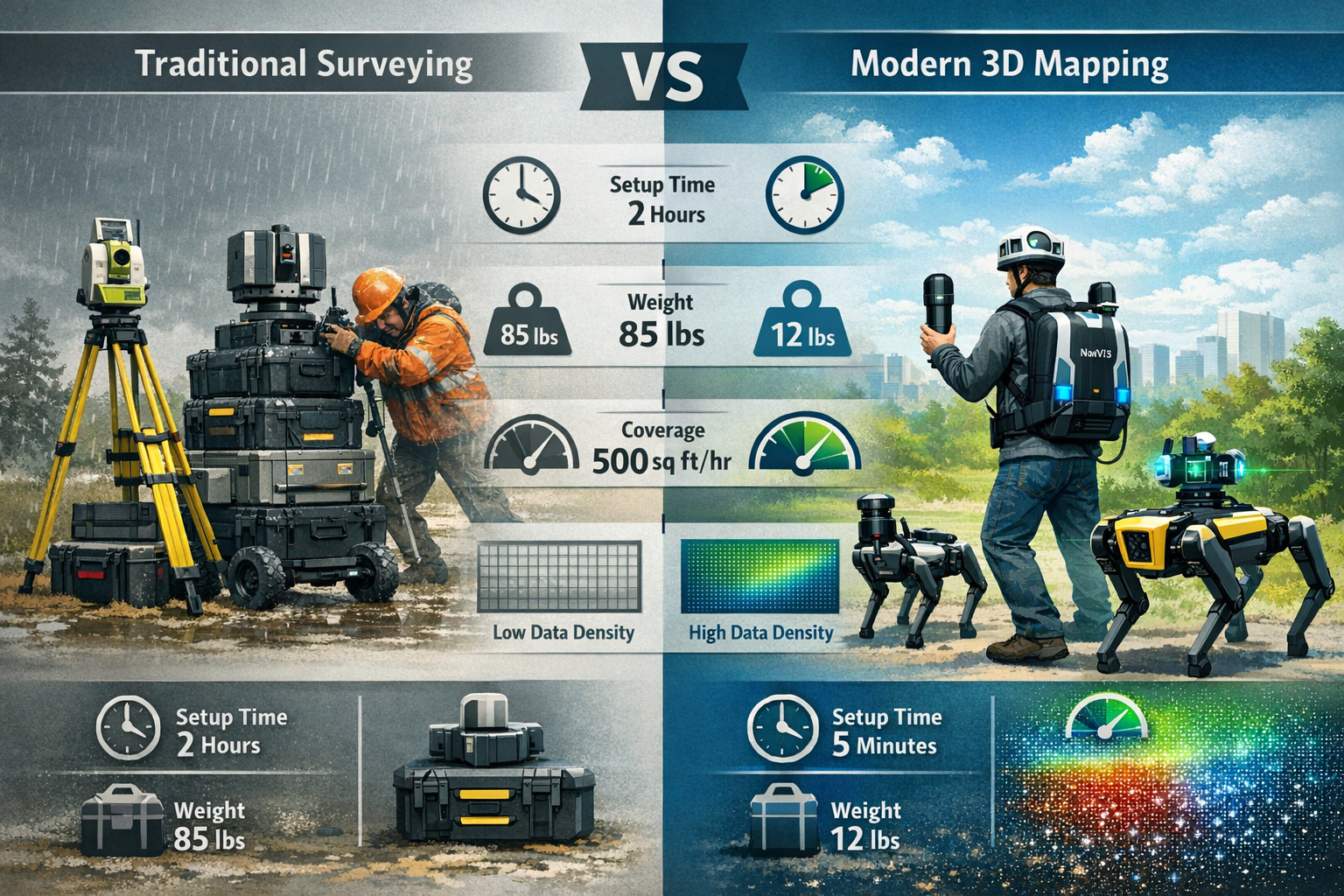
- Speed and Efficiency Gains: Mobile systems cover ground significantly faster than traditional methods—capturing up to 5,000 square feet per hour compared to 500 with static equipment—reducing project timelines and site visit requirements [1].
- Multi-Environment Versatility: The same mobile mapping platform handles both indoor and outdoor environments seamlessly, from confined building interiors to expansive urban developments, without workflow disruption [1].
- Integration-Ready Data: Modern systems produce survey-grade point clouds and models that integrate directly with GIS platforms, BIM software, and asset management systems, creating operational digital twins rather than static archives [2].
- Accessibility Without Compromise: Lightweight, portable systems access restricted spaces, hazardous areas, and complex facilities that traditional equipment cannot reach, while maintaining millimeter-scale accuracy for professional applications [5].
Understanding Digital Twins and Their Growing Importance
What Are Digital Twins?
A digital twin is a high-fidelity, interactive 3D model that serves as a virtual replica of a physical environment, asset, or system. Unlike simple 3D models or CAD drawings, true digital twins are dynamic—they integrate real-world data, update continuously as conditions change, and enable sophisticated analysis that would be impossible or dangerous to conduct in the physical world [6].
Digital twins transform how industries design, operate, optimize, and plan across sectors including geospatial, construction, transportation, infrastructure, utilities, and smart agriculture [4]. In the surveying context, digital twins provide:
- 📊 Accurate spatial documentation with millimeter-scale precision
- 🔄 Real-time or periodic updates reflecting current conditions
- 📐 Measurement capabilities for remote analysis and planning
- 🗂️ Asset integration linking physical objects to maintenance records, specifications, and operational data
- 🎯 Scenario testing for "what-if" planning before committing resources
Why Traditional Survey Methods Fall Short
Traditional surveying approaches rely on static equipment—total stations, tripod-mounted laser scanners, and terrestrial LiDAR systems—that require:
Time-Intensive Setup: Each scanning position demands careful leveling, calibration, and registration, consuming hours before data collection even begins.
Operational Disruption: Facilities must often shut down or restrict access while surveyors work, creating costly downtime and safety concerns.
Limited Coverage: Heavy equipment restricts access to confined spaces, upper floors without elevators, hazardous areas, or locations with challenging terrain.
Multiple Site Visits: Incomplete data or changing conditions frequently necessitate return trips, extending project timelines and increasing costs.
Fragmented Workflows: Different equipment for indoor versus outdoor environments creates data compatibility challenges and processing bottlenecks.
For professionals conducting building condition assessments or structural surveys, these limitations translate directly into project delays, increased expenses, and reduced competitiveness in a market demanding faster turnaround times.
Mobile 3D Mapping for Surveyors: Creating Digital Twins Without Bulky Equipment – The Technology Revolution
Core Technologies Enabling Mobile Mapping
Mobile mapping systems integrate three fundamental technologies into compact, portable packages that revolutionize data capture [1]:
1. LiDAR Sensors (Light Detection and Ranging)
Modern mobile LiDAR units emit millions of laser pulses per second, measuring the time-of-flight to calculate precise distances to surrounding surfaces. These measurements create dense point clouds—collections of millions of georeferenced 3D coordinates that represent the physical environment with extraordinary detail.
Advanced systems like the RIEGL VMY-2 employ dual LiDAR sensor configurations with spherical cameras to capture high-density 3D point clouds at millimeter-scale resolution [5]. This level of detail meets modern urban analysis requirements that traditional aerial datasets simply cannot provide.
2. Camera Arrays and Photogrammetry
High-resolution camera systems capture overlapping photographs that software processes through photogrammetry algorithms to generate textured 3D models. Critical camera features optimized for mobile mapping include [1]:
- High-resolution sensors that reduce interpolation errors and detect micro-cracks or surface wear
- High Dynamic Range (HDR) capabilities handling lighting extremes from bright reflective surfaces to shadowed interiors
- Multi-camera synchronization preventing temporal drift and frame mismatches during continuous movement
3. Positioning and Navigation Systems
Mobile mapping relies on sophisticated positioning technology combining:
- GNSS (Global Navigation Satellite Systems) for outdoor georeferencing
- IMU (Inertial Measurement Units) tracking acceleration and rotation
- SLAM (Simultaneous Localization and Mapping) algorithms that build maps while simultaneously determining the sensor's position within them—essential for GPS-denied indoor environments
Together, these technologies enable the three-method capture workflow: mobile mapping systems integrate LiDAR sensors, cameras, and positioning systems to generate dense point clouds and textured models through photogrammetry and SLAM pipelines, with data requiring fewer field passes than traditional static survey methods [1].
Wearable and Handheld Systems Leading the Market
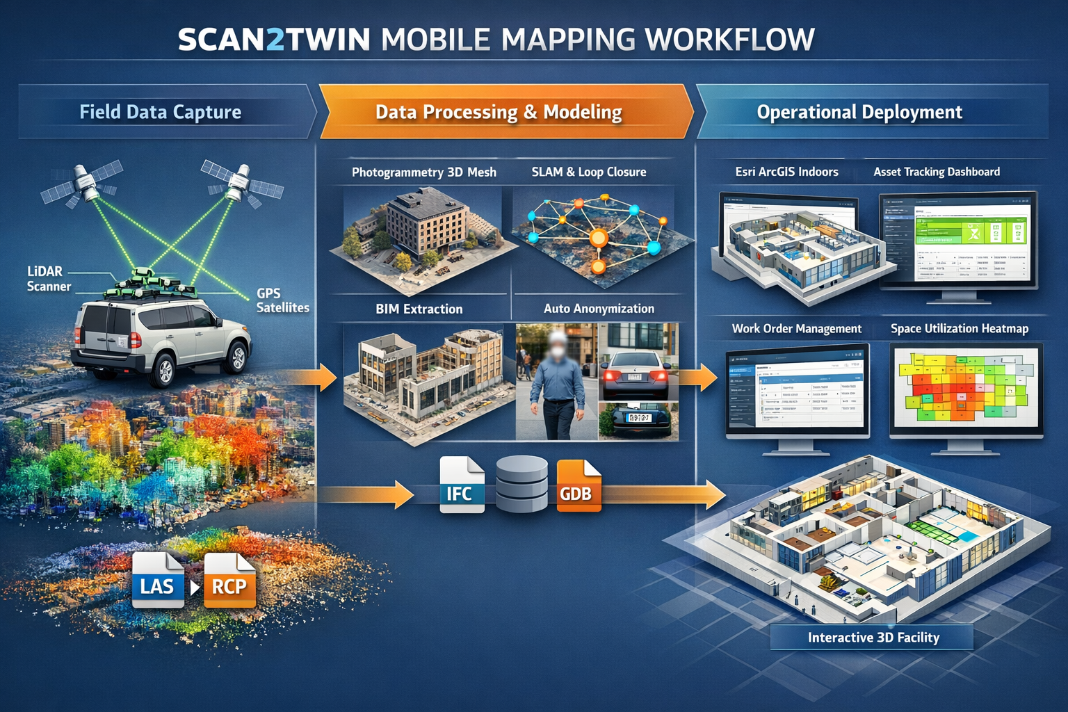
The evolution toward truly portable systems reached a milestone with wearable platforms that surveyors can operate while moving naturally through environments. At Geo Week 2026 in February, geoConvergence demonstrated Scan2Twin, a methodology combining [2]:
NavVis VLX3 Wearable Systems: Backpack-mounted units enabling continuous mobile mapping as surveyors walk through facilities at normal speed, capturing comprehensive data without disrupting operations.
BLK2GO Handheld Scanners: Compact devices for detailed scanning of specific areas, offering flexibility in confined spaces or when targeting particular assets.
Robotic Quadrupeds: Sensor-equipped robots accessing restricted or hazardous spaces that would be dangerous or impossible for human surveyors to enter.
This multi-platform approach delivers survey-grade data collection across diverse environments while maintaining workflow continuity [2]. The same methodology and data processing pipeline handles indoor facilities, outdoor sites, and everything in between—a level of versatility impossible with traditional equipment.
From Point Clouds to Operational Digital Twins
Raw data capture represents only the first step. The true power of mobile mapping emerges through integration with operational systems that transform static 3D models into actionable digital twins.
Scan2Twin exemplifies this evolution as an Esri-native methodology controlling the full pipeline from LiDAR point clouds through BIM processing to operational ArcGIS Indoors deployment [2]. This structured approach organizes data around:
- Assets: Individual equipment, fixtures, and building components linked to specifications, maintenance histories, and replacement schedules
- Work Orders: Maintenance tasks, repairs, and inspections connected to specific spatial locations
- Space Use: Occupancy patterns, utilization metrics, and optimization opportunities for facility management
This integration ensures digital twins serve immediate operational applications rather than becoming archived documentation that gathers digital dust. For surveyors working with property inspection and facility documentation, this operational focus creates ongoing value that justifies investment in mobile mapping technology.
Privacy and Compliance Built Into the Workflow
As mobile mapping systems capture increasingly detailed imagery of facilities and public spaces, privacy concerns naturally arise. Modern platforms address these challenges through automated anonymization ensuring PII (Personally Identifiable Information) and HIPAA compliance where required [2].
These systems automatically detect and blur faces, license plates, and other identifying information during processing, enabling surveyors to capture comprehensive spatial data while respecting privacy regulations and organizational policies.
Comparing Mobile 3D Mapping with Traditional Survey Methods
Speed and Efficiency: A Quantitative Analysis
The productivity advantages of mobile mapping systems become clear when comparing key performance metrics:
| Metric | Traditional Static Scanning | Mobile Mapping Systems | Improvement Factor |
|---|---|---|---|
| Setup Time per Position | 15-30 minutes | Continuous (no setup) | ⚡ Eliminated |
| Coverage Speed | 500-1,000 sq ft/hour | 5,000-10,000 sq ft/hour | 🚀 5-10× faster |
| Equipment Weight | 60-85 lbs (multiple cases) | 10-15 lbs (wearable/handheld) | 💪 75-85% reduction |
| Site Visits Required | 2-4 (typical project) | 1-2 (most projects) | ⏱️ 50% reduction |
| Operational Disruption | High (area closures required) | Minimal (walk-through capture) | ✅ Near-elimination |
Mobile mapping covers ground quickly and requires fewer site visits than traditional methods, cutting project hours and keeping projects on schedule even in areas with limited access [1]. For time-sensitive projects or facilities that cannot afford extended shutdowns, this speed advantage often determines project feasibility.
Accuracy Considerations: Meeting Professional Standards
A common concern about mobile systems centers on accuracy—can lightweight, portable equipment match the precision of traditional survey-grade instruments?
The answer depends on application requirements:
Traditional Static Scanning delivers the highest absolute accuracy (±1-3mm at typical ranges) and remains the gold standard for:
- Precise engineering measurements
- Deformation monitoring requiring sub-millimeter precision
- Legal boundary surveys
- Control network establishment
Mobile Mapping Systems achieve impressive accuracy (±5-20mm depending on conditions and processing) suitable for:
- Building documentation and digital twins
- Facility management and asset tracking
- Construction progress monitoring
- Infrastructure condition assessment
- Urban planning and development
Modern mobile systems like those equipped with dual LiDAR sensors capture data at millimeter-scale resolution [5], meeting professional requirements for the vast majority of surveying applications. Road safety audits, for example, can now be analyzed remotely with sub-centimeter accuracy to reveal hazards like poor sightlines or hazardous curves [7].
For professionals conducting topographic mapping or comprehensive condition surveys, mobile systems deliver accuracy well within acceptable tolerances while dramatically reducing field time.
Accessibility and Versatility Advantages
Perhaps the most transformative advantage of mobile mapping lies in accessing environments that traditional equipment cannot:
Confined Spaces: Handheld scanners navigate narrow corridors, crawl spaces, attics, and mechanical rooms where tripod-mounted equipment won't fit.
Multi-Story Buildings: Wearable systems climb stairs continuously, eliminating the need to transport heavy equipment between floors or arrange elevator access.
Hazardous Areas: Robotic platforms enter contaminated zones, structurally compromised buildings, or active industrial areas without risking surveyor safety.
Active Facilities: Walk-through capture proceeds while facilities remain operational, eliminating costly shutdowns and scheduling conflicts.
Mixed Environments: The same system handles both indoor and outdoor environments without workflow disruption [1], maintaining data consistency across complex sites.
This versatility proves especially valuable for building surveyors documenting diverse property types, from historic structures with challenging access to modern facilities requiring minimal operational disruption.
Cost-Benefit Analysis: Total Project Economics
Initial equipment costs for mobile mapping systems appear higher than traditional instruments, but total project economics tell a different story:
Reduced Labor Costs: Faster data capture means fewer billable hours and smaller field crews.
Fewer Site Visits: Single-visit capture eliminates travel time, mobilization costs, and scheduling overhead for return trips.
Operational Savings: Clients avoid costly facility shutdowns, production delays, and access coordination.
Expanded Market Access: Ability to efficiently handle projects that would be impractical with traditional methods opens new revenue opportunities.
Data Reuse Value: Comprehensive digital twins serve multiple purposes—documentation, facility management, renovation planning, asset tracking—maximizing return on data capture investment.
For surveying practices evaluating technology investments, mobile mapping systems typically achieve ROI within 6-18 months through productivity gains and expanded service capabilities.
Real-World Applications: Mobile 3D Mapping for Surveyors Creating Digital Twins
Large-Scale Urban Development: The Northstowe Case Study
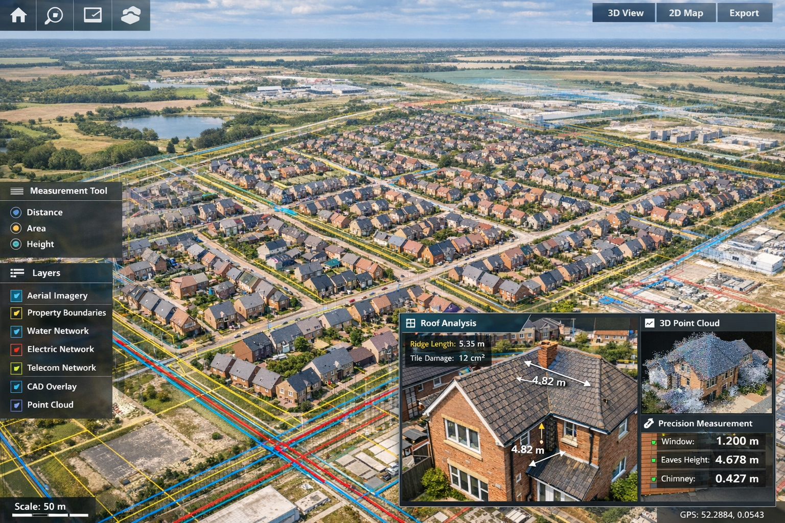
One of the most impressive demonstrations of mobile mapping scalability comes from Northstowe, a new town development in the UK. Skytech Cambridge captured more than 40,000 high-resolution aerial photographs to create a browser-based digital twin of the entire development [3].
Project Scope and Methodology:
The digital twin encompasses all data fully georeferenced and integrated with existing GIS datasets and CAD drawings, creating a unified spatial database accessible through standard web browsers. As of summer 2025, approximately 1,750 homes in Northstowe were occupied and are now visible and measurable in the digital twin model [3].
Operational Benefits:
This comprehensive digital twin enables:
- Development Monitoring: Track construction progress across the entire town development in real-time
- Infrastructure Planning: Visualize utility networks, transportation systems, and public spaces in spatial context
- Asset Management: Link individual buildings and infrastructure components to maintenance schedules and specifications
- Public Engagement: Share accessible visualizations with stakeholders and residents through browser-based interfaces
The Northstowe project demonstrates the scalability of mobile mapping systems across entire facility portfolios [3], proving these technologies handle projects ranging from individual buildings to entire communities.
Transportation Infrastructure and Road Safety
Transportation agencies face unique challenges documenting extensive linear infrastructure—highways, railways, transit systems—where traditional surveying methods prove prohibitively time-consuming and disruptive to traffic.
Mobile mapping systems mounted on vehicles capture continuous data along transportation corridors at normal driving speeds, creating comprehensive digital twins of roadway assets including:
- Pavement conditions and surface distress
- Traffic signs and markings
- Guardrails and safety barriers
- Drainage infrastructure
- Vegetation encroachment
- Sight distance and geometric compliance
Road safety audits can now be analyzed remotely with sub-centimeter accuracy to reveal hazards like poor sightlines or hazardous curves, and planners can test "what-if" scenarios virtually before committing resources [7]. This capability transforms safety analysis from periodic field inspections to continuous monitoring and proactive intervention.
For agencies managing extensive networks, digital twins created through mobile mapping provide the spatial foundation for asset management systems tracking billions of dollars in infrastructure investments.
Facility Management and Industrial Applications
Industrial facilities, hospitals, universities, and commercial real estate portfolios represent ideal applications for mobile mapping technology. These environments demand:
- Minimal Operational Disruption: Facilities cannot shut down for extended survey periods
- Comprehensive Documentation: Thousands of assets require spatial tracking and maintenance coordination
- Regular Updates: Facilities evolve through renovations, equipment changes, and space reconfigurations
- Multi-System Integration: Spatial data must connect with CMMS, BIM, and enterprise asset management platforms
The Scan2Twin methodology specifically addresses these requirements by structuring data around assets, work orders, and space use for immediate operational application [2]. Facility managers gain interactive 3D models where clicking on equipment instantly reveals:
- Manufacturer specifications and installation dates
- Maintenance histories and upcoming service schedules
- Warranty information and replacement costs
- Energy consumption and performance metrics
This operational integration transforms digital twins from documentation tools into active management platforms driving efficiency improvements and cost reductions.
Heritage Documentation and Historic Preservation
Historic structures present unique surveying challenges: complex architectural details, fragile materials, restricted access, and the need to document without physical contact or disruption. Mobile mapping systems excel in these applications through:
Non-Contact Capture: LiDAR and photogrammetry document structures without physical measurement or mounting equipment on historic fabric.
Comprehensive Detail: High-resolution scanning captures ornamental details, surface textures, and structural conditions at millimeter scale.
Accessibility: Handheld and wearable systems navigate tight staircases, attics, bell towers, and other spaces where traditional equipment cannot operate.
Archival Quality: Digital twins preserve accurate spatial records for future restoration, research, and virtual access.
For professionals conducting structural surveys of historic properties, mobile mapping provides documentation quality impossible to achieve through traditional measurement methods while respecting conservation principles.
The Future of Mobile 3D Mapping: Emerging Trends for 2026 and Beyond
Real-Time Digital Twins and Continuous Updates
The next evolution in digital twin technology involves real-time updates—high-fidelity, interactive 3D models that update continuously as new data is collected [6]. This capability allows developers and planners to:
- Visualize how environments behave under various conditions
- Detect subtle wear or new construction early
- Monitor compliance with design specifications during construction
- Track facility changes automatically without manual surveys
Integration with IoT sensors, building automation systems, and monitoring equipment creates digital twins that reflect not just spatial geometry but also dynamic conditions—temperature, occupancy, equipment status, and environmental parameters.
Artificial Intelligence and Automated Feature Extraction
Manual processing of point cloud data remains time-consuming, requiring skilled technicians to identify and classify features. AI-powered automation is transforming this workflow through:
Automated Object Recognition: Machine learning algorithms identify assets, infrastructure components, and building elements directly from point clouds.
Defect Detection: AI systems flag cracks, corrosion, deformation, and other condition issues automatically, prioritizing areas requiring professional review.
Change Detection: Comparing sequential scans reveals modifications, construction progress, or unauthorized alterations without manual comparison.
Semantic Enrichment: Automated classification tags objects with metadata, linking spatial features to asset databases and specifications.
These capabilities reduce processing time from weeks to days while improving consistency and completeness of deliverables.
Integration with Augmented Reality (AR)
Augmented reality applications overlay digital twin data onto real-world views through smartphones, tablets, or AR glasses, creating powerful field tools for:
- Construction Verification: Compare as-built conditions against design models in real-time
- Maintenance Guidance: Display equipment locations, access routes, and service procedures overlaid on physical spaces
- Facility Navigation: Guide visitors or emergency responders through complex buildings with spatial overlays
- Renovation Planning: Visualize proposed changes in context before construction begins
For surveyors, AR integration transforms digital twins from office analysis tools into field-deployable resources supporting decision-making at the point of work.
Democratization Through Cloud Platforms
Cloud-based processing and hosting platforms are making mobile mapping accessible to smaller practices and individual professionals who previously lacked the infrastructure for large-scale 3D data management. These platforms provide:
- Browser-Based Processing: Upload field data and receive processed models without local computing infrastructure
- Collaborative Access: Share digital twins with clients, consultants, and stakeholders through web links
- Scalable Storage: Host extensive point cloud libraries without local server investments
- Subscription Models: Access professional-grade capabilities through monthly subscriptions rather than capital equipment purchases
This democratization expands mobile mapping adoption beyond large firms to the broader surveying community, including practices offering homebuyers surveys and residential property services.
Implementing Mobile 3D Mapping in Your Surveying Practice
Evaluating System Options and Requirements
Selecting appropriate mobile mapping technology requires careful assessment of:
Project Types and Environments:
- Primarily indoor, outdoor, or mixed applications?
- Typical site sizes and complexity levels?
- Access constraints and operational limitations?
- Required accuracy specifications?
Integration Requirements:
- Existing software platforms (CAD, GIS, BIM)?
- Client deliverable formats and standards?
- Data management and storage infrastructure?
- Workflow compatibility with current processes?
Budget and ROI Considerations:
- Equipment acquisition costs (purchase vs. lease)?
- Training and learning curve investments?
- Processing software and cloud platform subscriptions?
- Expected productivity gains and revenue opportunities?
For practices serving diverse markets—from London property surveyors conducting residential inspections to commercial facility documentation—versatile systems handling multiple applications provide the best return on investment.
Training and Skill Development
Mobile mapping technology requires new competencies beyond traditional surveying skills:
Field Capture Techniques: Understanding optimal walking speeds, scanning patterns, and coverage strategies for different environments.
SLAM Principles: Recognizing conditions that challenge simultaneous localization and mapping algorithms and implementing mitigation strategies.
Point Cloud Processing: Managing large datasets, registration workflows, and quality control procedures.
Software Proficiency: Mastering processing platforms, visualization tools, and integration with CAD/GIS/BIM environments.
Client Communication: Explaining digital twin capabilities, deliverable formats, and application possibilities to non-technical stakeholders.
Manufacturers typically provide training programs, and professional organizations offer continuing education addressing mobile mapping workflows and best practices.
Data Management and Processing Workflows
Mobile mapping generates massive datasets—individual projects can produce hundreds of gigabytes of point cloud data, imagery, and derivative products. Effective data management requires:
Structured Storage: Organized file hierarchies, naming conventions, and metadata standards ensuring data remains accessible and usable long-term.
Processing Pipelines: Standardized workflows from field data through registration, cleaning, classification, and deliverable generation.
Quality Control: Systematic verification procedures confirming accuracy, completeness, and deliverable compliance with project specifications.
Archival Strategies: Long-term retention policies balancing storage costs against potential future value and professional liability requirements.
Security and Backup: Protecting client data through encryption, access controls, and redundant backup systems.
For practices handling sensitive property inspections and confidential facility documentation, robust data security protocols are essential professional responsibilities.
Marketing Mobile Mapping Capabilities
Differentiating your practice through advanced technology requires effective communication of capabilities and benefits:
Client Education: Help clients understand how digital twins solve their specific challenges—facility management, renovation planning, asset tracking, compliance documentation.
Visual Demonstrations: Showcase interactive 3D models, virtual walkthroughs, and measurement capabilities through portfolio examples and case studies.
Value Proposition: Emphasize speed, minimal disruption, comprehensive documentation, and ongoing utility rather than technical specifications.
Service Packaging: Bundle mobile mapping with complementary services—building surveys, condition assessments, facility audits—creating comprehensive solutions.
Industry Positioning: Participate in professional forums, publish case studies, and engage with industry trends demonstrating thought leadership and technical expertise.
Effective marketing transforms mobile mapping from a technical capability into a competitive advantage attracting clients seeking modern, efficient surveying solutions.
Overcoming Common Challenges and Limitations
Environmental Conditions Affecting Data Quality
Mobile mapping systems face challenges in certain environmental conditions:
Reflective Surfaces: Glass, polished metal, and water can create erroneous returns or data gaps in LiDAR scans.
Lighting Extremes: Very bright or very dark areas challenge camera systems, though HDR capabilities mitigate many issues [1].
GPS-Denied Environments: Indoor spaces and urban canyons require SLAM algorithms that can drift over extended capture sessions without loop closures.
Dynamic Scenes: Moving people, vehicles, or equipment create noise in point clouds requiring filtering during processing.
Vegetation: Dense foliage can obscure ground surfaces and structures in outdoor applications.
Understanding these limitations enables surveyors to implement mitigation strategies—optimal capture times, supplementary control measurements, and processing techniques addressing specific challenges.
Balancing Automation with Professional Judgment
While mobile mapping systems automate data capture and processing increasingly handles routine tasks, professional expertise remains essential:
- Interpreting data quality and identifying artifacts or errors
- Determining appropriate accuracy specifications for specific applications
- Recognizing structural conditions, defects, and safety concerns
- Communicating findings effectively to clients and stakeholders
- Applying regulatory knowledge and professional standards
Technology augments rather than replaces professional judgment. The most effective implementations combine automated efficiency with experienced interpretation and analysis.
Managing Client Expectations
Digital twin technology generates excitement, but managing client expectations prevents misunderstandings:
Accuracy Limitations: Clearly communicate precision specifications and appropriate applications versus situations requiring traditional survey methods.
Data Processing Time: Explain that comprehensive processing requires time despite rapid field capture—clients should understand realistic delivery schedules.
File Sizes and Access: Large point cloud files may challenge client systems; provide appropriate formats and viewing options for different technical capabilities.
Ongoing Maintenance: Digital twins become outdated as facilities change; discuss update frequencies and long-term data management responsibilities.
Cost Justification: Help clients understand value proposition—comprehensive documentation, operational integration, and long-term utility justify investment versus traditional approaches.
Clear communication establishes realistic expectations and positions mobile mapping as a professional service rather than a commodity product.
Conclusion: Embracing the Future of Surveying
Mobile 3D mapping for surveyors creating digital twins without bulky equipment represents far more than incremental technological improvement—it's a fundamental transformation in how professionals document, analyze, and manage the built environment. The convergence of lightweight LiDAR sensors, sophisticated SLAM algorithms, high-resolution imaging, and cloud-based processing has created capabilities that seemed impossible just a few years ago.
The evidence is compelling: wearable systems capturing survey-grade data while walking at normal speed [2], entire town developments documented with over 40,000 georeferenced photographs [3], road safety analyses conducted remotely with sub-centimeter accuracy [7], and comprehensive facility digital twins integrated directly with operational asset management systems [2]. These aren't future possibilities—they're current realities transforming surveying practice in 2026.
For surveying professionals, the strategic question isn't whether to adopt mobile mapping technology but how to implement it most effectively within their specific practice context. The productivity advantages, expanded service capabilities, and competitive differentiation these systems provide make them increasingly essential for practices seeking to thrive in a digital-first industry.
Actionable Next Steps
1. Assess Your Practice Needs: Evaluate your typical project types, client requirements, and operational constraints to identify where mobile mapping delivers the greatest value.
2. Research Available Systems: Investigate platforms ranging from handheld scanners to wearable systems and vehicle-mounted solutions, comparing capabilities against your specific requirements.
3. Develop Implementation Plan: Create a phased adoption strategy addressing equipment acquisition, training, workflow integration, and client communication.
4. Invest in Training: Prioritize skill development for yourself and your team, leveraging manufacturer programs, professional education, and hands-on practice.
5. Start Small, Scale Strategically: Begin with pilot projects demonstrating capabilities and building confidence before expanding to full-scale implementation.
6. Engage with Industry Trends: Stay current with evolving technologies, emerging applications, and best practices through professional organizations and industry publications.
The future of surveying belongs to professionals who embrace technological innovation while maintaining the professional judgment, ethical standards, and client focus that define the profession. Mobile 3D mapping technology provides the tools; your expertise, experience, and commitment to excellence determine the outcomes.
Whether you're conducting property surveys across London, documenting complex industrial facilities, or managing large-scale infrastructure projects, mobile mapping systems offer capabilities that enhance your professional practice and deliver exceptional value to your clients. The transformation is underway—the question is how you'll participate in shaping the future of surveying.
References
[1] 3d Mobile Mapping For Digital Twins – https://www.electronicspecifier.com/studentzone/learning/year-2/digital-systems-and-design/3d-mobile-mapping-for-digital-twins/
[2] Geoconvergence Introduces Scan2twin Mobile Mapping For Digital Twin Creation Gis Integration – https://www.geoweeknews.com/news/geoconvergence-introduces-scan2twin-mobile-mapping-for-digital-twin-creation-gis-integration
[3] Mapping A New Town With 3d Digital Twin Technology – https://www.gim-international.com/content/news/mapping-a-new-town-with-3d-digital-twin-technology
[4] How Intelligent Digital Replicas Are Reshaping The World – https://geospatial.trimble.com/blog/geospatial/en-US/article/how-intelligent-digital-replicas-are-reshaping-the-world
[5] Mobile Mapping System For Urban Infrastructure Monitoring Digital Twin Implementation In Road Asset Management – https://www.riegl.com/en-austria/news-insights/article/mobile-mapping-system-for-urban-infrastructure-monitoring-digital-twin-implementation-in-road-asset-management
[6] Future Land Surveying 2026 – https://haller-blanchard.com/future-land-surveying-2026/
[7] Mapping The Future Of Digital Twins Transforming Transportation Cad To Gis – https://sanborn.com/blog/mapping-the-future-of-digital-twins-transforming-transportation-cad-to-gis/