

Nearly one in five boundary disputes handled by the First-tier Tribunal (Property Chamber) involves a narrow strip or gap between adjoining plots that neither neighbour can confidently claim. For homeowners, buyers and conveyancers across England and Wales, understanding property boundaries and gap issues between adjoining UK properties is not a theoretical exercise, it is a practical necessity that can affect property values, planning applications, and the outcome of a sale.
This article explains what boundary gaps are, why they arise, how surveyors identify and measure them, and what legal routes exist to resolve them.
Key Takeaways
- Most registered properties in England and Wales have general boundaries only, meaning the exact legal line is not defined on the title plan.
- A gap between two adjoining properties may belong to one owner, the other, or may represent genuinely unallocated land.
- HM Land Registry cannot resolve boundary disputes directly; owners must reach agreement or apply for a determined boundary.
- A professional boundary or building survey provides the evidence base needed to resolve gap disputes efficiently.
- Formal resolution options include a boundary agreement, a determined boundary application (Form DB), or, where land has changed hands, a transfer deed.
What Is a Boundary Gap and Why Does It Happen
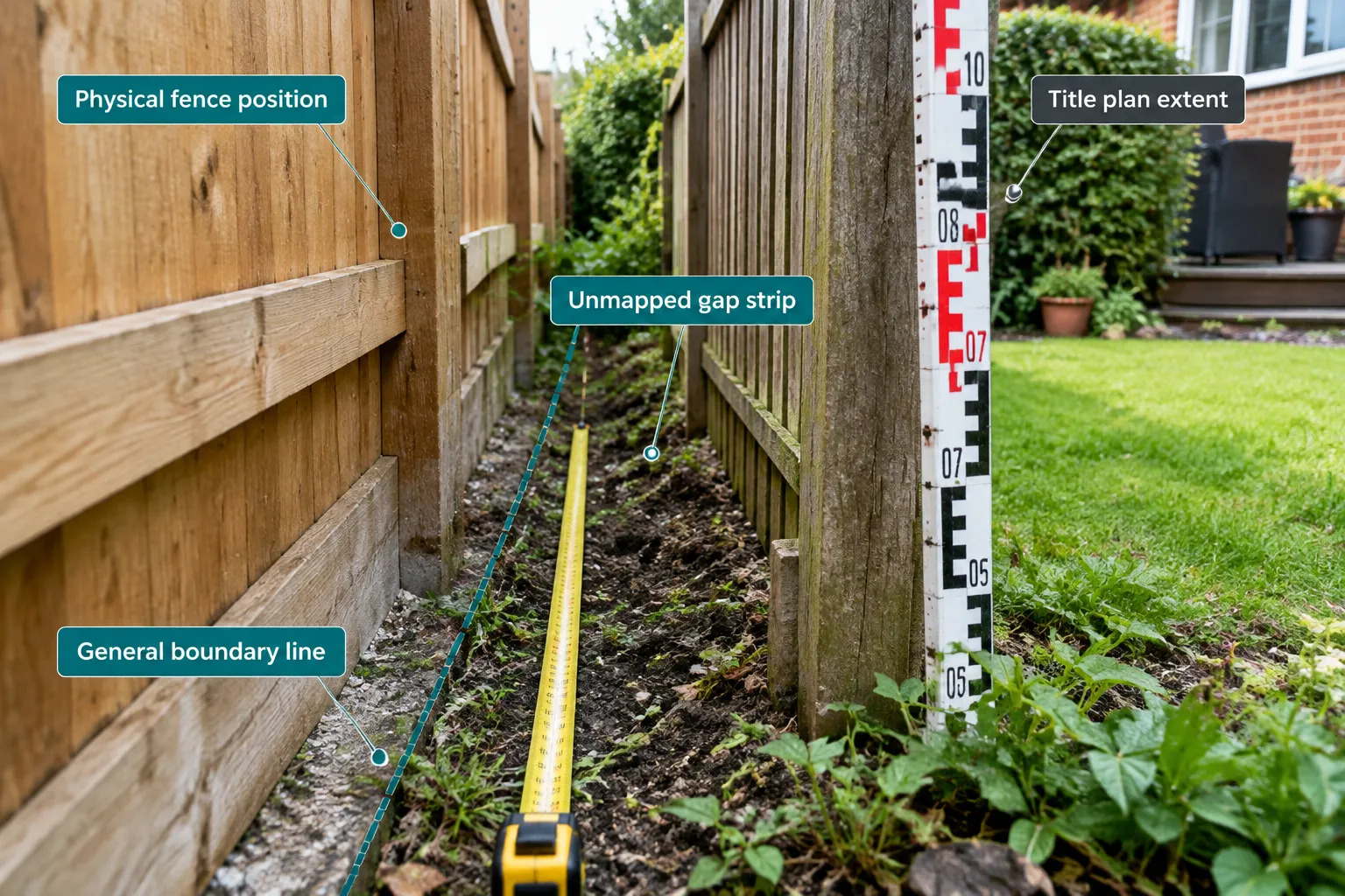
A boundary gap is a narrow strip of land, sometimes only a few centimetres wide, sometimes a metre or more, that sits between the physical features marking two adjoining properties. It may appear as an unoccupied space between two fences, a strip of ground between a wall and a hedge, or an unmaintained corridor running along the side of a driveway.
These gaps arise for several interconnected reasons.
The general boundary rule is the most fundamental cause. HM Land Registry's Practice Guide 40, Supplement 3 makes clear that the boundary shown on a title plan is a general boundary only, not a precise legal line [2]. Title plans are based on Ordnance Survey mapping, which uses a scale that can represent a metre or more of ground as a hairline on paper. The filed plan shows an approximate position, not an exact one [1].
Incremental physical changes compound the problem. Over decades, fences are replaced and repositioned, hedges grow outward or are cut back, and walls are rebuilt slightly off their original line. Each small change can create or widen an apparent gap between what the plan shows and what exists on the ground.
Subdivision and development errors are another common source. When a larger plot is divided, for example, when a house is sold with part of its garden as a separate building plot, the transfer plan may not perfectly account for every physical feature, leaving a sliver of land that does not clearly fall within either new title.
"The legal boundary is an imaginary or invisible line dividing one person's property from that of another.", HM Land Registry Practice Guide 40, Supplement 3 [2]
Because the legal boundary is invisible, it is entirely possible for two neighbours to each believe their fence or wall sits on the correct line, yet for a gap to exist between them. Neither party is necessarily wrong about their own title; the gap may simply reflect the imprecision built into the registration system from the outset.
For a broader understanding of how UK property boundaries are recorded and interpreted, it is worth reviewing the Land Registry's own guidance alongside a professional surveyor's assessment.
How Surveyors Identify and Measure Boundary Gaps
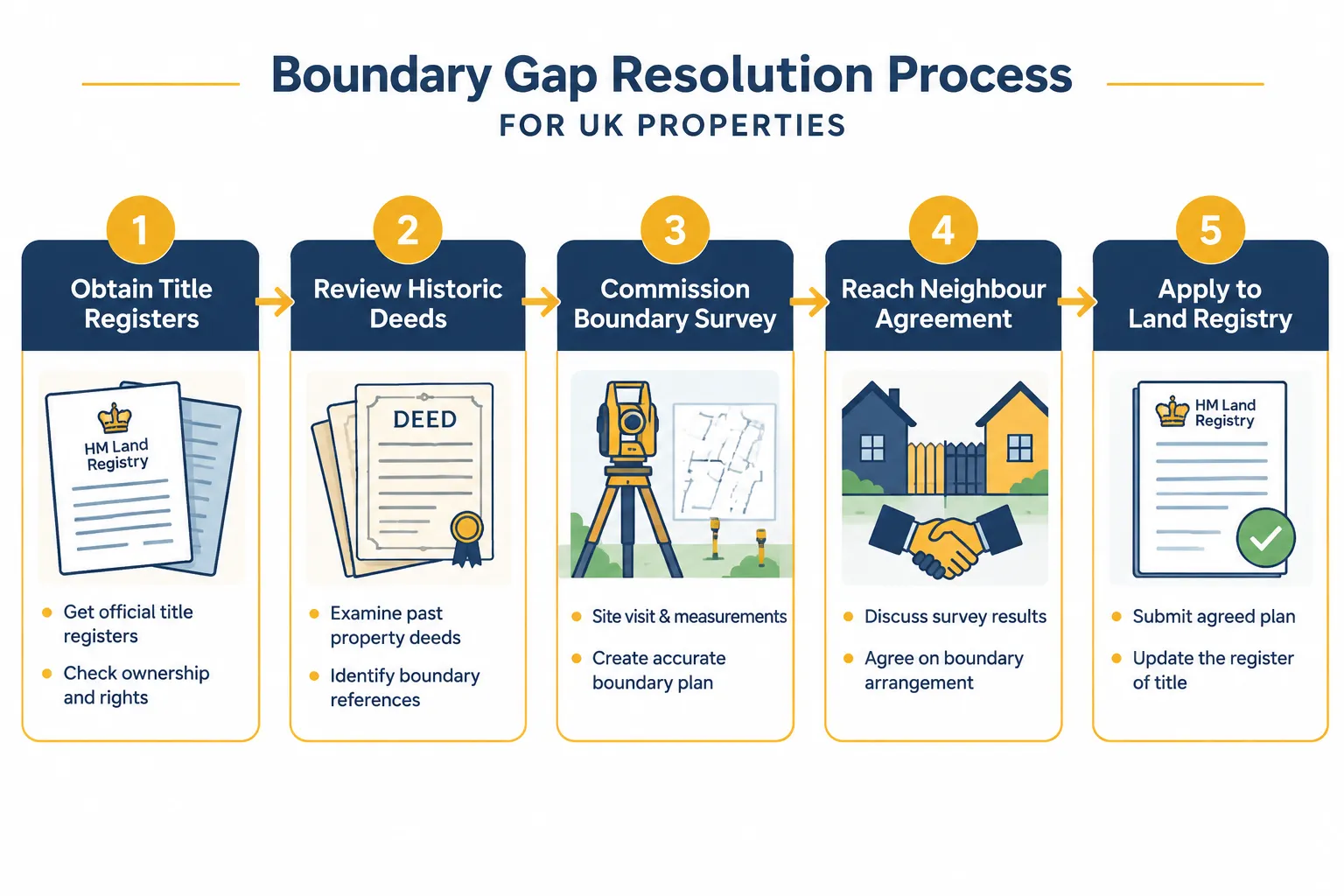
Identifying a boundary gap requires a structured approach that combines document analysis with precise physical measurement. This is where a qualified surveyor adds significant value, both in establishing the facts and in producing evidence that can support a legal resolution.
Document Review: The Starting Point
Before any site work begins, a thorough document review is essential. Owners and their advisers should examine:
- The title register and title plan for each adjoining property
- All deeds and deed plans copied by Land Registry at the time of registration
- Any original uncopied deeds held by the owner or their solicitor
- Historic conveyances, which often contain more precise descriptions of boundary features and measurements than modern transfers [11]
- Lease plans where either property is leasehold
Older conveyances are particularly valuable. They frequently describe boundaries by reference to specific physical features, "the fence on the north side", "the wall belonging to the vendor", and may include measurements that allow the intended line to be reconstructed on the ground [11].
HM Land Registry's own blog notes that a combination of title registers, historic deeds, physical features and professional advice is needed to understand boundaries, and that apparent gaps should not be assumed to belong to either neighbour without proper investigation [1].
Site Survey: Measuring the Gap
Once the documentary picture is assembled, a surveyor carries out a measured site survey. The key steps are:
- Identify all physical boundary features, fences, walls, hedges, ditches, kerbs, and record their positions using a total station or GPS equipment capable of high-accuracy measurement.
- Measure the gap between the physical features of each property, recording width at multiple points along its length.
- Photograph all features systematically, including any markers, pegs or notches that may indicate historic boundary positions.
- Compare measured positions with the title plans, noting discrepancies between the physical features and the general boundary shown.
- Assess ownership indicators such as which side of a fence the posts sit on, the direction of any arris rails, and evidence of maintenance.
The surveyor then produces a scaled plan showing both the general boundary from the title plan and the measured positions of physical features, clearly identifying the gap and its dimensions.
This type of detailed property inspection is distinct from a standard homebuyer's survey, though a building survey may flag boundary issues as part of its scope. For properties where boundary certainty is critical, such as those with narrow side accesses, shared driveways or recent development, commissioning a dedicated boundary survey is strongly advisable.
A property evaluation that overlooks boundary gaps can expose buyers to disputes that emerge only after completion, so raising the issue early in the transaction is always the better course.
Common Dispute Scenarios Involving Gaps
The table below summarises the most frequently encountered gap scenarios and their typical causes.
| Scenario | Typical Cause | Key Evidence Needed |
|---|---|---|
| Gap between two garden fences | Fences repositioned over time | Historic deeds, aerial photographs |
| Strip alongside a shared driveway | Subdivision plan imprecision | Transfer deed plan, measurements |
| Gap between wall and title plan line | Wall rebuilt off original line | Original conveyance, site measurements |
| Unoccupied strip after new build | Developer’s plan did not allocate strip | Developer’s transfer plans, site survey |
| Gap revealed during planning application | General boundary imprecision | High-accuracy survey, title plans |
Legal Routes for Resolving Boundary Gap Issues
Once a gap has been identified and measured, the question becomes: how is ownership resolved? Understanding property boundaries and gap issues between adjoining UK properties requires knowing that Land Registry does not automatically resolve these situations. Owners must take proactive steps [14].
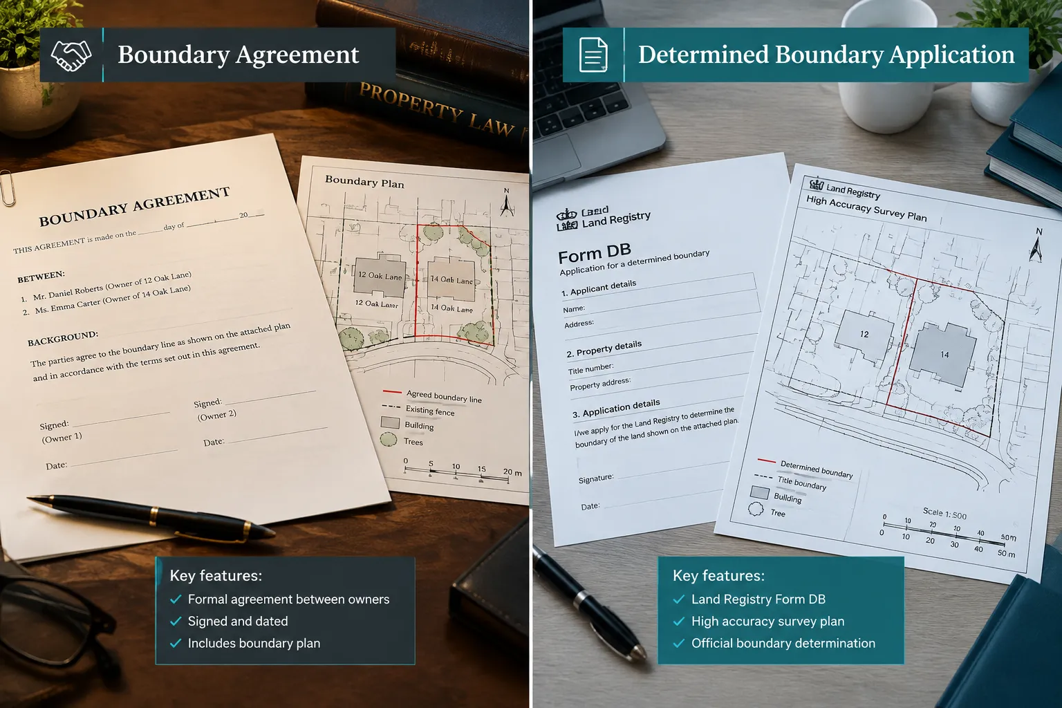
There are three principal routes, each suited to different circumstances.
Route 1: Boundary Agreement
A boundary agreement is the most straightforward option when both neighbours accept a particular line. The parties enter into a written agreement that:
- Describes the agreed boundary in unambiguous terms
- Attaches a supporting plan showing the exact agreed line in relation to physical features
- Is signed by both parties
Once signed, either party can apply using Form AP1 to have the agreement noted on the title registers of both properties [12]. This does not change the registered titles but adds a record that increases certainty for future buyers, mortgage lenders and planners.
A boundary agreement is particularly well-suited to resolving a narrow gap where both owners are content to accept the physical features, such as an existing fence, as the boundary, even if the title plan is slightly inconsistent.
Route 2: Determined Boundary Application
Where a more conclusive and binding record is needed, or where the gap has been contentious, owners can apply for a determined boundary under section 60 of the Land Registration Act 2002 using Form DB [4].
A determined boundary application requires:
- A high-quality, high-accuracy plan precisely showing the claimed line in relation to physical features
- Supporting evidence such as historic deeds, measurements and photographs
- Agreement from the adjoining owner, or service of notice on them
If the neighbour agrees, the registrar records the determined boundary on both title registers, making it conclusive [7][8]. If the neighbour objects, Land Registry will typically refer the dispute to the First-tier Tribunal (Property Chamber) for a decision [4].
It is important to note that Land Registry cannot mediate or directly resolve boundary disputes. Its staff cannot use the register or title plans to establish the precise legal boundary, and owners cannot rely on the plan alone to allocate a gap [10]. The determined boundary process exists precisely because the general boundary system does not provide this certainty by default.
Route 3: Transfer Deed
Where the gap represents land that has effectively been used, maintained or occupied by one neighbour for a significant period, or where both parties agree that the strip should formally pass from one title to the other, the appropriate mechanism is a transfer deed and transfer plan [9]. This records the change of ownership and is then registered at Land Registry, adding the strip to the transferee's title.
This route is also used where adverse possession, long, uninterrupted occupation of land without the owner's permission, may have given one party a claim to the strip, though adverse possession claims under the Land Registration Act 2002 involve a separate notification process.
When Disputes Escalate
If informal negotiation and the routes above fail, parties face either tribunal proceedings or court litigation. The Civil Justice Council's Boundary Disputes Guidance Note strongly urges the use of mediation, expert determinations and pre-litigation protocols before resorting to litigation [3]. Tribunal hearings typically occur around six months after referral, and costs can quickly become disproportionate to the value of the land in dispute, a particular concern when the gap is only a few centimetres wide [3].
For those dealing with property disputes involving boundary gaps, early specialist legal advice is essential. Moving fences, cutting hedges or building on a disputed strip before taking advice can seriously prejudice a party's position [4].
Owners of adjoining properties who are considering construction near a shared boundary should also be aware of the Party Wall etc. Act 1996, which imposes separate notice requirements for work on or near boundary walls and structures. For guidance on building walls on property lines, a surveyor can advise on both the boundary position and the party wall implications simultaneously.
The Role of a Building Survey in Evidencing Boundary Gaps
A standard valuation or mortgage survey will not investigate boundary gaps in detail. A Level 3 Building Survey (formerly a full structural survey) or a dedicated boundary survey is the appropriate tool when boundary certainty is needed.
A building survey commissioned before purchase can identify:
- Discrepancies between the physical features and the title plan
- Signs that a fence or wall has been moved
- Evidence of encroachment by a neighbour's structure
- Gaps that may affect planning permission for extensions or outbuildings
For buyers, raising boundary questions before exchange, rather than after completion, preserves negotiating options and avoids inheriting a dispute. Reviewing a homebuyers report or building survey guide can help buyers understand which level of survey is appropriate for their circumstances.
Surveyors in areas with high property density, such as those served by Ealing property surveyors or Wandsworth property surveyors, regularly encounter boundary gap issues in terraced and semi-detached properties where side accesses and narrow plots make precise boundaries especially important.
Key questions a surveyor should be asked to address:
- Does the physical boundary match the title plan?
- Is there any visible gap between this property and the adjoining plot?
- Are there signs that boundary features have been moved?
- Are there any structures that appear to encroach on or over the boundary?
- Are there any rights of way or access arrangements affecting the boundary area?
Practical Steps for Owners Facing a Boundary Gap
The following sequence reflects best practice for owners who discover or suspect a boundary gap:
- Obtain the title registers and title plans for both properties from HM Land Registry.
- Gather all available deeds, including any original conveyances predating registration.
- Commission a measured boundary survey to establish the physical position of all features and the extent of any gap.
- Photograph all boundary features systematically, recording dates.
- Do not move, remove or alter any boundary features until legal advice has been obtained.
- Open a dialogue with the neighbour at an early stage, ideally before positions become entrenched.
- Seek specialist legal advice from a solicitor experienced in property and boundary law.
- Consider mediation before making any formal application or commencing proceedings.
- Formalise any agreement by boundary agreement or determined boundary application, and register it at Land Registry.
Conclusion
Understanding property boundaries and gap issues between adjoining UK properties is a matter that deserves serious attention from owners, buyers and conveyancers alike. The general boundary system that underpins land registration in England and Wales is efficient for most purposes, but it was never designed to resolve narrow strips of disputed or unallocated land with precision.
The practical reality is that a gap between two properties will not resolve itself. Land Registry cannot allocate it, and neither neighbour can safely assume ownership without evidence. The combination of a thorough document review, a high-accuracy measured survey and early dialogue with the adjoining owner is the most cost-effective path to resolution.
Actionable next steps:
- If buying a property with a narrow side access, shared driveway or boundary features that do not obviously match the title plan, commission a Level 3 Building Survey or dedicated boundary survey before exchange.
- If a gap has already been identified, gather all deeds and title plans and seek specialist legal advice before taking any physical action.
- If both neighbours are willing to agree the line, formalise that agreement promptly and register it at Land Registry to protect both parties in future transactions.
- Where agreement cannot be reached, explore mediation before pursuing a tribunal or court route, the costs of litigation rarely reflect the value of the land in dispute.
Early, evidence-based action is always less expensive than a contested tribunal hearing. A qualified surveyor is the right first call.
References
[1] Drawing The Line On Boundaries – hmlandregistry.blog.gov.uk
[2] Land Registry Plans Boundaries Practice Guide 40 Supplement 3 – gov.uk
[3] CJC Boundary Disputes Guidance Note Aug 2018 – judiciary.uk
[4] Boundary Disputes Land Registry – towers-richardson.co.uk
[6] Land Registration Practice Guides – gov.uk
[7] Practice Guide 40 Land Registry Plans Supplement 4 Boundary Agreements And Determined Boundaries – gov.uk
[8] Practice Guide 40 Land Registry Plans Supplement 4 Boundary Agreements And Determined Boundaries – gov.uk
[9] Guide to Resolving Boundary Disputes – boundary-problems.co.uk
[10] HM Land Registry Customer Help Forum – customerhelp.landregistry.gov.uk