
{"cover":"Professional landscape format (1536×1024) hero image with bold text overlay: 'Virtual Tours & AR/VR in Property Surveying' in extra large 72pt white bold sans-serif font with dark semi-transparent background panel, centered upper-third composition. Background shows a surveyor wearing a mixed-reality headset standing inside a period London townhouse, with holographic floor plan overlays and 3D measurement grids floating in the air around them. Color scheme: deep navy blue, white text, gold accent lines. Editorial magazine quality, high contrast, futuristic yet professional aesthetic.","content":["Landscape format (1536×1024) editorial illustration showing a split-screen composition: left side depicts a traditional RICS surveyor with clipboard inside a brick Victorian property in London; right side shows the same property rendered as a photorealistic 3D virtual tour on a laptop screen with AR measurement overlays, hotspot markers, and drone footage thumbnail. Bold label 'From Physical to Digital: The Surveying Revolution' in dark navy text at bottom. Clean infographic style, professional color palette of slate grey, white, and teal accents.","Landscape format (1536×1024) technical infographic-style image showing a drone hovering above a row of London terraced houses, transmitting data wirelessly to a tablet held by a property surveyor on the ground. The tablet screen displays an AR overlay with structural annotations, damp risk zones highlighted in amber, and 3D point-cloud mapping lines. Small inset panels show VR headset view of interior spaces with measurement callouts. Color scheme: charcoal, electric blue, amber highlights. Data-driven, proptech aesthetic, editorial quality.","Landscape format (1536×1024) forward-looking concept image depicting a remote property investor sitting at a modern home-office desk in 2026, wearing a lightweight AR headset, viewing an immersive virtual walkthrough of a London flat. On the desk, multiple screens show RICS survey data, condition ratings, and a condition survey report dashboard. Through the window behind them, a London skyline is visible. Overlay text reads 'Remote Assessments: The Future of Property Due Diligence'. Professional, aspirational tone, color palette of warm white, deep blue, and gold."]
By 2026, the global AR/VR ecosystem has surged to USD 118.79 billion — up from USD 75.18 billion just one year prior — representing nearly 25% compound annual growth [1]. Within that broader wave, the dedicated VR real estate market is valued at USD 1.21 billion and is projected to reach USD 3.03 billion by 2035 [1]. These are not speculative figures. They reflect a structural shift already reshaping how chartered surveyors, property investors, and buyers conduct due diligence. Virtual Tours and AR/VR in Property Surveying: Enhancing Remote Assessments is no longer a futuristic concept — it is an active professional discipline with measurable commercial impact.
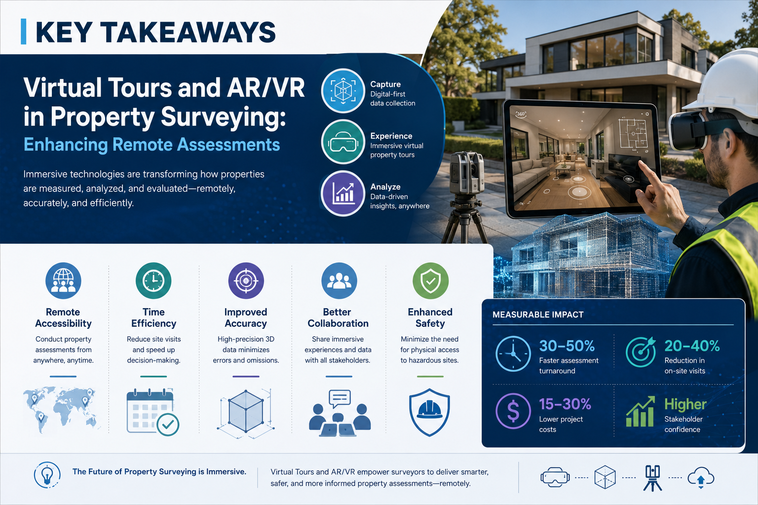
Key Takeaways
- The global VR real estate market reached USD 1.21 billion in 2026 and is on track to triple by 2035, driven by demand for remote property assessment tools.
- AR and VR technologies allow surveyors to conduct immersive, data-rich remote inspections that reduce travel costs and accelerate transaction timelines.
- Drone integration with AR/VR platforms creates layered aerial and interior datasets, giving investors and surveyors unprecedented property visibility.
- Virtual tours do not replace RICS-accredited physical surveys but serve as powerful pre-inspection and investor-screening tools.
- Adoption is accelerating across London and the wider UK market, with proptech platforms increasingly embedding these tools into standard workflows.
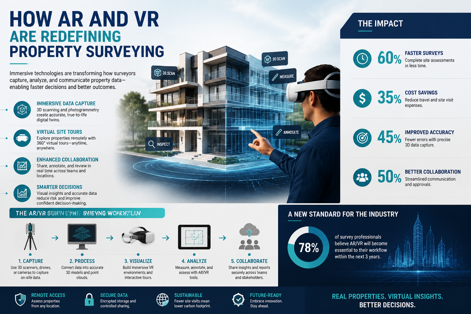
How AR and VR Are Redefining Property Surveying
Traditional property surveying has always been constrained by geography and time. A surveyor must physically travel to a site, conduct a visual inspection, and produce a written report — a process that can take days from instruction to delivery. AR (augmented reality) and VR (virtual reality) technologies are dismantling those constraints by enabling immersive, data-rich assessments that can be conducted, reviewed, and shared remotely.
Virtual reality creates a fully immersive digital environment. In a property context, this means a photorealistic 360-degree walkthrough of a building that a surveyor or client can navigate from any location using a headset or browser-based viewer. Augmented reality, by contrast, overlays digital information — measurements, structural annotations, condition flags — onto a live or recorded view of a real space.
The distinction matters for surveyors. VR is primarily used for remote viewing and client presentations, while AR is increasingly embedded into active inspection workflows. A surveyor using an AR-enabled tablet on-site can, for example, overlay historical building data, flag suspected damp zones in real time, or annotate structural cracks with severity ratings that feed directly into a digital report.
Goldman Sachs estimated VR's value in real estate at USD 2.6 billion by 2026, a figure that aligns closely with independent market analyses [5]. These numbers reflect adoption across property marketing, transaction due diligence, and — critically — professional surveying services.
The Role of 360-Degree Virtual Tours
360-degree virtual tours have become the most widely adopted entry point for immersive property technology. Platforms such as Matterport and similar tools capture spatial data using LiDAR or structured-light scanning, producing navigable 3D models that preserve accurate room dimensions and surface detail.
For property professionals, these models offer several concrete advantages:
- Pre-inspection screening: A surveyor can review a virtual tour before visiting a property, identifying areas that warrant closer physical examination.
- Client communication: Buyers and investors can explore a property remotely before committing to a physical viewing or instructing a survey.
- Documentation: The 3D model serves as a timestamped record of a property's condition at a specific point in time — valuable in dispute resolution or reinspection scenarios.
Before instructing any formal assessment, understanding what to do before an RICS home survey remains essential. Virtual tours support that preparation process by giving all parties a shared visual reference point.
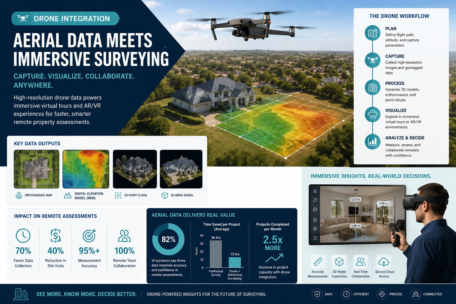
Drone Integration: Aerial Data Meets Immersive Surveying
One of the most significant proptech developments supporting Virtual Tours and AR/VR in Property Surveying: Enhancing Remote Assessments is the integration of drone technology with immersive platforms. Drones equipped with high-resolution cameras, thermal imaging sensors, and LiDAR scanners can capture exterior data — rooflines, chimney stacks, guttering, cladding — that is difficult or dangerous to access on foot.
When that aerial data is combined with interior virtual tours, the result is a comprehensive digital twin of a property: a layered, navigable model that captures both the visible structure and underlying condition indicators.
Thermal Imaging and Condition Mapping
Thermal drone surveys are particularly relevant for identifying heat loss, moisture ingress, and insulation deficiencies — issues that are often invisible to standard visual inspection. When these thermal datasets are rendered as AR overlays within a virtual tour, a surveyor can pinpoint problem areas with spatial precision.
This is especially relevant for damp surveys in London, where older housing stock and variable drainage conditions make moisture-related defects a persistent concern. Thermal AR overlays can flag suspected damp zones before a physical inspection, allowing the surveyor to focus time and equipment on the most critical areas.
Investor Appeal in the Remote Work Era
The remote work era has fundamentally altered where people live and how they buy property. Buyers are increasingly purchasing homes in locations they have never physically visited, relying on digital tools to conduct preliminary due diligence. Property investors — particularly those operating across multiple geographies — are among the most active adopters of AR/VR surveying tools [3].
For London-based investors evaluating properties in outer boroughs or commuter zones, virtual tours combined with drone-captured exterior surveys reduce the need for multiple site visits before committing to a formal inspection. This efficiency translates directly into reduced acquisition costs and faster transaction timelines.
Surveyors covering areas such as Bromley, Newham, and Romford are increasingly fielding requests from investors who have conducted initial virtual assessments and want a formal RICS survey to validate their findings before exchange.
Practical Applications: Virtual Tours and AR/VR in Property Surveying: Enhancing Remote Assessments
The practical deployment of these technologies spans several distinct use cases within the surveying profession. Understanding where they add genuine value — and where they have limitations — is essential for both practitioners and clients.
Pre-Purchase Due Diligence
For buyers and their advisers, virtual tours provide an efficient first filter. Rather than instructing a full building survey on every property under consideration, a buyer can use a high-quality virtual tour to shortlist properties that merit formal inspection. This is particularly valuable in competitive markets where speed matters.
AR tools can further enhance this process by enabling remote annotation — a surveyor reviewing a virtual tour can flag visible defects, note areas of concern, and share a preliminary condition summary with the client before any physical visit takes place.
Condition Surveys and Dilapidations
Commercial property professionals have been early adopters of AR/VR tools in the context of dilapidations and condition survey reports. At lease end, landlords and tenants often dispute the condition of a property. A timestamped virtual tour conducted at lease commencement provides an objective baseline against which end-of-lease condition can be compared.
AR overlays can highlight specific defects, cross-reference them with schedule of condition entries, and produce annotated reports that are far more visually compelling — and legally defensible — than written descriptions alone.
Remote Valuations and Red Book Assessments
While RICS standards require physical inspection for most formal valuations, virtual tours are increasingly used as a supplementary tool in desktop review and preliminary valuation stages. Surveyors conducting Red Book valuations can use high-quality virtual tour data to inform comparable analysis and identify features or defects that affect value, reducing the number of follow-up visits required.
Comparing Survey Types: Where AR/VR Adds the Most Value
The table below summarises how AR/VR tools integrate with different survey types and the degree of value they add at each stage.
| Survey Type | AR/VR Application | Value Added |
|---|---|---|
| RICS Level 1 Condition Report | Virtual tour for client review | Moderate — supports client understanding |
| RICS Level 2 Homebuyer Report | Pre-inspection virtual screening | High — focuses surveyor attention |
| RICS Level 3 Building Survey | Drone + thermal AR overlays | Very High — supplements physical inspection |
| Damp and Timber Survey | Thermal imaging AR mapping | High — identifies moisture zones pre-visit |
| Dilapidations / Condition Survey | Timestamped 3D model baseline | Very High — provides objective evidence |
| Commercial Valuation | Virtual tour + desktop review | Moderate — supports comparable analysis |
Understanding which home survey is right for a given property remains a decision that requires professional judgement — but AR/VR tools are increasingly informing that decision earlier in the process.
Limitations and Professional Standards
It would be misleading to present AR/VR as a wholesale replacement for physical surveying. RICS professional standards are explicit: a formal survey requires physical inspection by a qualified chartered surveyor. Virtual tools are supplementary, not substitutional.
Several limitations are worth noting:
- Scan quality variability: Consumer-grade 360-degree cameras produce lower-resolution models than professional LiDAR scanners. Defects such as hairline cracks, early-stage damp, or minor structural movement may not be visible in a virtual tour.
- Hidden elements: No virtual tour can reveal what is behind walls, beneath floors, or within roof voids. Physical inspection remains essential for assessing concealed construction.
- Liability: A surveyor who relies solely on a virtual tour for a formal assessment carries significant professional liability risk. RICS guidance is clear that virtual tools support but do not replace on-site inspection.
- Technology access: Not all clients have access to VR headsets or high-bandwidth internet connections, which can limit the practical utility of immersive formats in some markets.
These limitations do not diminish the value of AR/VR tools — they define the appropriate context for their use. The most effective workflows combine immersive digital tools with rigorous physical inspection, using each to enhance the other.
The London Market: Adoption Trends in 2026
London's property market presents a particularly compelling case for AR/VR adoption. The city's geographic spread, diverse housing stock, and high transaction values create strong incentives for efficiency tools that reduce time-on-market and due diligence costs.
Surveyors operating across inner and outer London boroughs — from Westminster and Knightsbridge to Lewisham and Hounslow — are reporting increased client requests for virtual tour integration as part of pre-survey briefings.
The commercial sector has moved furthest and fastest. AR/VR tools are now considered standard practice in commercial real estate marketing and due diligence across major London submarkets [9]. Residential adoption is accelerating, particularly among buyers purchasing new-build or off-plan properties, where a physical structure may not yet exist.
"The ability to walk through a property virtually before instructing a survey is not a luxury — it is rapidly becoming a baseline expectation among informed buyers and investors." — Industry consensus, 2026 [9]
Proptech platforms are also driving adoption from the supply side. Major portals and estate agency groups have invested heavily in virtual tour infrastructure, meaning that high-quality 3D models are now available for a growing proportion of listed properties. This creates a ready data source for surveyors who want to conduct preliminary remote assessments before visiting a site.
Looking Ahead: The Next Phase of AR/VR in Surveying
Several emerging developments are likely to shape the next phase of AR/VR adoption in property surveying:
AI-assisted defect detection: Machine learning models trained on large datasets of property defects are being integrated with virtual tour platforms. These tools can flag potential issues — such as crack patterns consistent with subsidence or staining patterns associated with damp — automatically within a 3D model, before a surveyor has reviewed the tour.
Mixed reality (MR) headsets: Lightweight MR devices that blend physical and digital environments are becoming more affordable and practical for on-site use. A surveyor wearing an MR headset can overlay building plans, previous survey reports, and real-time measurement data onto their physical view of a property — dramatically accelerating the inspection process [8].
BIM integration: Building Information Modelling (BIM) data is increasingly being linked to virtual tour platforms, allowing surveyors to access detailed construction specifications, material schedules, and maintenance histories within an immersive environment.
Blockchain-verified condition records: Timestamped, tamper-proof virtual tour records stored on distributed ledgers are being explored as a mechanism for creating verifiable property condition histories — with obvious implications for conveyancing, insurance, and dispute resolution [7].
These developments reinforce the trajectory: AR/VR tools will become more deeply embedded in professional surveying workflows, not as novelties, but as standard instruments of practice.
Conclusion
The integration of Virtual Tours and AR/VR in Property Surveying: Enhancing Remote Assessments represents one of the most consequential shifts in property due diligence in a generation. The market data is unambiguous — investment in immersive property technology is accelerating, adoption among professionals is broadening, and client expectations are rising in step.
Actionable next steps for property professionals and buyers in 2026:
- Request virtual tour data early: When instructing a survey, ask whether a high-quality 3D model or drone survey is available. Use it to brief your surveyor and focus their attention on priority areas.
- Understand the boundaries: Virtual tours are a powerful screening and communication tool, but they do not replace a physical RICS-accredited inspection. Always instruct a qualified chartered surveyor for formal assessments.
- Evaluate AR tools for commercial work: If you manage a commercial portfolio or are involved in dilapidations, explore AR-enabled condition survey platforms that can produce annotated, timestamped reports.
- Stay current with RICS guidance: Professional standards around the use of remote assessment tools are evolving. Chartered surveyors should monitor RICS updates to ensure their use of AR/VR remains compliant.
- Engage a local specialist: Whether buying in central London or an outer borough, work with surveyors who are familiar with the specific housing stock and can integrate digital tools with local market knowledge.
The technology is here. The market has validated it. The professionals who master the combination of immersive digital tools and rigorous physical inspection will define the next standard of property surveying practice.
References
[1] Virtual Reality Property Tours 2026 – https://www.coradvisors.net/2026/02/virtual-reality-property-tours-2026.html
[2] Revolutionizing Property Viewing With Ar Vr Technology In Real Estate – https://nexgits.com/revolutionizing-property-viewing-with-ar-vr-technology-in-real-estate/
[3] Virtual And Augmented Reality Are Redefining Property Exploration – https://www.bostonbrandmedia.com/news/virtual-and-augmented-reality-are-redefining-property-exploration
[4] How Virtual Reality And Augmented Reality Are Revolutionizing Real Estate – https://aurorealty.com/blog/how-virtual-reality-and-augmented-reality-are-revolutionizing-real-estate/
[5] The Rise Of Ar In Real Estate Virtual Property Tours And Remote Home Buying – https://hello.ar/the-rise-of-ar-in-real-estate-virtual-property-tours-and-remote-home-buying/
[6] Vr Property Tours Usa Virtual Reality Real Estate Marketing 2026 – https://www.chasingillusions.com/vr-property-tours-usa-virtual-reality-real-estate-marketing-2026/
[7] Virtual And Augmented Reality Tours A Deep Dive Into The Future Of Commercial Real Estate – https://lumicre.com/realestate/virtual-and-augmented-reality-tours-a-deep-dive-into-the-future-of-commercial-real-estate/
[8] Jeffreyeberger How Vr Ar And Mr Are Redefining Real Estate Activity – https://www.linkedin.com/posts/jeffreyeberger_how-vr-ar-and-mr-are-redefining-real-estate-activity-7461755081043050496-plGZ
[9] Ar Property Tours Why They Re Standard In 2026 – https://vocal.media/01/ar-property-tours-why-they-re-standard-in-2026
[10] How Real Estate Sites Are Moving To Ar Vr Experience For Home Buyers And Builders – https://www.cisin.com/coffee-break/how-real-estate-sites-are-moving-to-ar-vr-experience-for-home-buyers-and-builders.html


