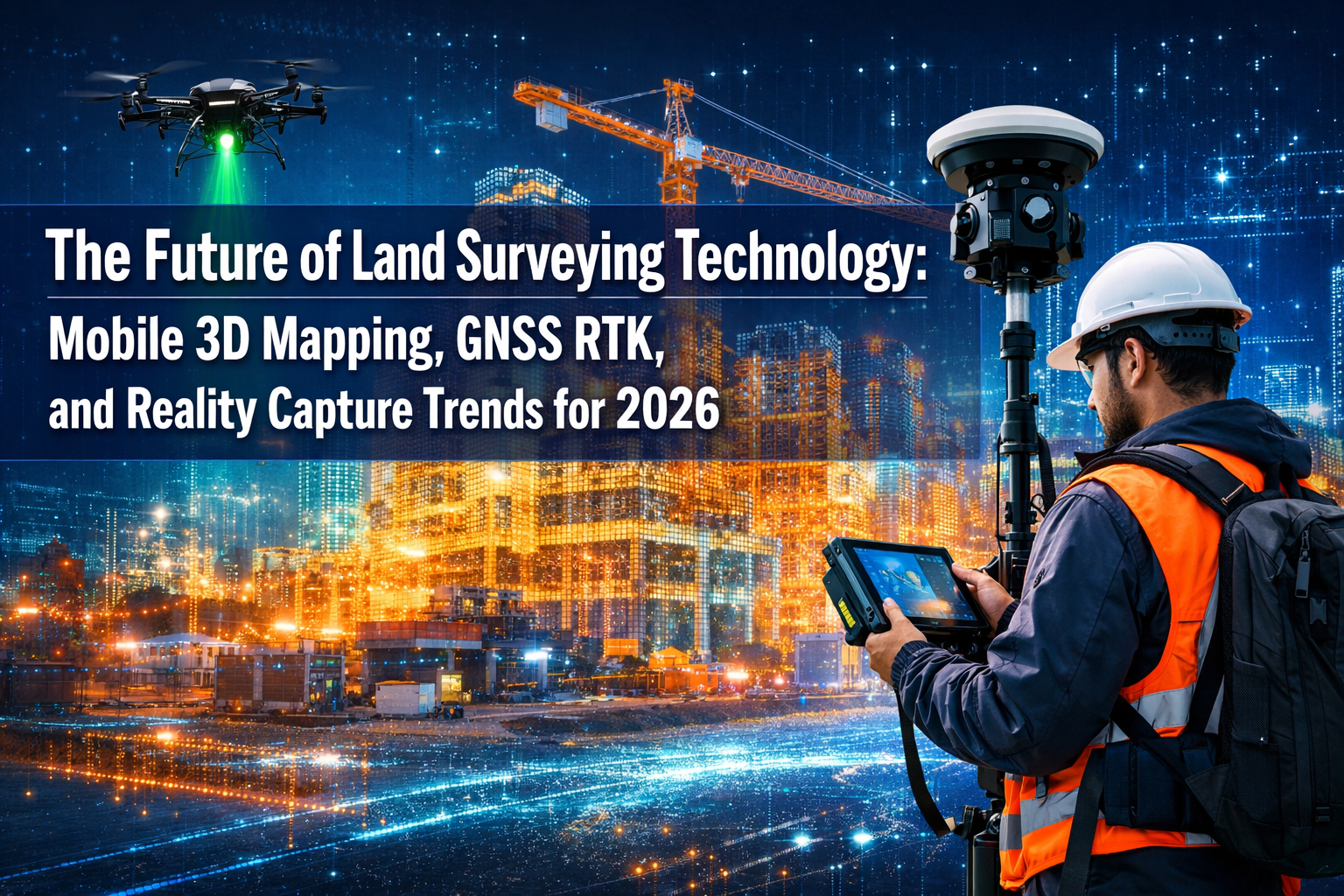
The land surveying industry stands at a remarkable turning point in 2026. What once required weeks of fieldwork, heavy equipment, and extensive manual calculations can now be accomplished in days—or even hours—using advanced mobile 3D mapping systems, precision GNSS RTK technology, and reality capture platforms. The Future of Land Surveying Technology: Mobile 3D Mapping, GNSS RTK, and Reality Capture Trends for 2026 represents more than just incremental improvements; it signals a fundamental transformation in how surveyors collect, process, and deliver spatial data to clients.
Small and medium-sized surveying firms, which historically struggled to compete with larger organizations equipped with expensive technology, now find themselves on increasingly level ground. Mobile mapping solutions have become remarkably accessible, drone-based LiDAR systems have dropped dramatically in price, and cloud-based processing platforms eliminate the need for costly in-house computing infrastructure. This democratization of advanced surveying technology is reshaping the competitive landscape while accelerating project timelines across residential, commercial, and infrastructure sectors.
Key Takeaways
- 📱 Mobile 3D mapping systems enable surveyors to create detailed indoor and outdoor digital models without bulky equipment, significantly reducing processing time and making advanced technology accessible to smaller firms
- 🛰️ GNSS RTK technology delivers centimeter-level accuracy in real-time, allowing faster and more precise surveys even in challenging environments when combined with post-processing kinematic (PPK) positioning
- 🚁 Multi-sensor autonomous drones equipped with synchronized LiDAR, photogrammetry cameras, and thermal imaging transform data collection by covering large areas quickly while surveying previously inaccessible terrain
- 🤖 AI-assisted processing is now embedded directly into surveying workflows, instantly classifying terrain, identifying markers, and generating preliminary models while providing quality control alerts before projects reach drafting stages
- ☁️ Cloud-based platforms have shifted deliverables from static documents to interactive 3D digital twins that update continuously, enabling real-time collaboration among surveyors, engineers, architects, and clients
Understanding Mobile 3D Mapping Technology in Modern Surveying
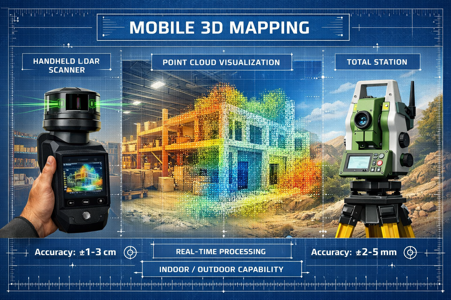
Mobile 3D mapping has emerged as one of the most transformative technologies reshaping land surveying in 2026. Unlike traditional surveying methods that require stationary equipment and extensive setup time, mobile mapping systems allow surveyors to capture comprehensive spatial data while moving through environments—both indoors and outdoors—with unprecedented speed and flexibility.[1]
What Makes Mobile 3D Mapping Revolutionary
At its core, mobile 3D mapping combines several technologies into a single portable system. These typically include LiDAR sensors (Light Detection and Ranging), high-resolution cameras, inertial measurement units (IMUs), and GNSS receivers. The integration of these components creates a synchronized data collection platform that captures millions of measurement points per second while maintaining precise positional accuracy.[1]
The real breakthrough lies in how these systems process data. Modern mobile mapping platforms can generate digital replicas rapidly, with significantly reduced processing time compared to traditional methods.[1] What once required days of post-processing can now be accomplished in hours, allowing surveyors to deliver preliminary results to clients almost immediately after fieldwork completion.
Indoor and Outdoor Versatility: A Game-Changer for Small Firms
One of the most significant advantages of mobile 3D mapping technology is its ability to seamlessly transition between indoor and outdoor environments. This versatility proves particularly valuable for projects involving:
- Mixed-use developments requiring both interior space planning and exterior site surveys
- Industrial facilities where equipment layouts must be documented alongside surrounding infrastructure
- Historic buildings needing detailed interior documentation for renovation planning
- Commercial properties requiring comprehensive as-built documentation for property condition assessments
For smaller surveying firms, this versatility eliminates the need to invest in separate equipment systems for different project types. A single mobile mapping unit can handle diverse assignments that previously would have required multiple specialized tools, making advanced surveying capabilities financially accessible to organizations of all sizes.
Accessibility and Cost Considerations
The democratization of mobile 3D mapping technology represents a fundamental shift in the surveying industry. While early systems cost hundreds of thousands of dollars and required specialized training, modern solutions have become significantly more affordable and user-friendly.[1]
Key accessibility improvements include:
| Feature | Traditional Systems | Modern Mobile 3D Mapping |
|---|---|---|
| Equipment Weight | 50-100+ lbs | 5-15 lbs |
| Setup Time | 30-60 minutes | 5-10 minutes |
| Training Required | Weeks to months | Days to weeks |
| Processing Software | Specialized workstations | Cloud-based platforms |
| Cost Range | $150,000-$500,000 | $25,000-$150,000 |
This accessibility enables smaller firms to compete for projects that previously went exclusively to larger organizations with extensive equipment inventories. The reduced physical demands also mean that a wider range of professionals can operate these systems effectively, addressing workforce challenges facing the surveying industry.
Project Acceleration Through Mobile Technology
Perhaps the most compelling benefit of mobile 3D mapping is its impact on project timelines. Traditional surveying methods require surveyors to establish control points, set up equipment repeatedly, and manually record measurements at discrete locations. Mobile systems, by contrast, capture continuous data as the surveyor moves through the site.
A typical commercial property survey that might require three to five days using traditional methods can often be completed in a single day with mobile 3D mapping.[2] This acceleration doesn't compromise accuracy—modern systems maintain precision comparable to or exceeding traditional techniques while dramatically increasing data density.
The time savings extend beyond fieldwork. Because mobile systems capture comprehensive spatial information in a single pass, surveyors spend less time returning to sites for additional measurements. This reduces travel costs, minimizes disruption to clients, and allows firms to complete more projects with the same staff resources.
GNSS RTK Technology: Achieving Centimeter-Level Precision in Real-Time
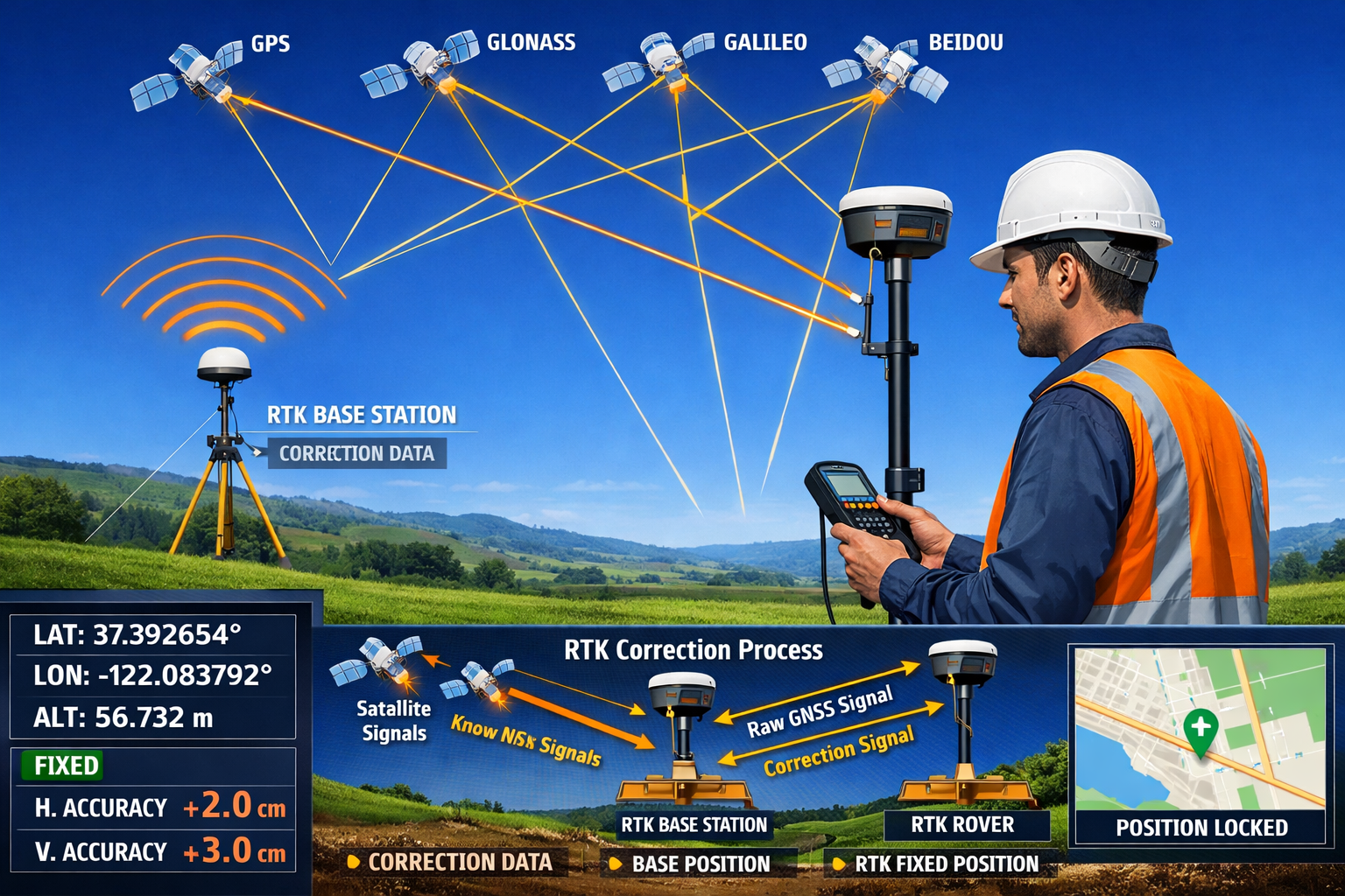
Global Navigation Satellite System (GNSS) Real-Time Kinematic (RTK) technology has revolutionized positioning accuracy in land surveying. In 2026, RTK systems have become standard equipment for surveyors requiring centimeter-level accuracy in real-time, enabling faster and more accurate work even in challenging environments.[4]
How GNSS RTK Systems Deliver Unprecedented Accuracy
Traditional GPS technology provides accuracy within several meters—sufficient for navigation but inadequate for professional surveying. RTK technology achieves precision improvements of 100-fold or more by using a two-receiver system that corrects satellite signal errors in real-time.
The RTK system consists of:
- Base Station: A stationary receiver positioned at a known coordinate that receives satellite signals and calculates correction data
- Rover Receiver: A mobile unit carried by the surveyor that receives both satellite signals and correction data from the base station
- Communication Link: Radio, cellular, or internet connection transmitting corrections from base to rover
By comparing the satellite signals received at both locations and applying differential corrections, RTK systems achieve horizontal accuracy of ±8-15mm and vertical accuracy of ±15-20mm—precise enough for virtually all surveying applications.[4]
RTK and PPK: Complementary Approaches to Precision Positioning
While RTK provides real-time corrections, Post-Processing Kinematic (PPK) positioning offers an alternative approach that proves valuable in certain situations. PPK records raw satellite data during fieldwork and applies corrections afterward using specialized software.[1]
When to use RTK versus PPK:
RTK Advantages:
- ✅ Immediate confirmation of measurement quality
- ✅ Instant stakeout and layout capabilities
- ✅ No post-processing delay
- ✅ Immediate detection of positioning errors
PPK Advantages:
- ✅ Works in areas with poor cellular/radio coverage
- ✅ Allows data collection to continue if base station connection is lost
- ✅ Can apply corrections from multiple reference stations for improved accuracy
- ✅ Enables reprocessing if initial results are questionable
Many modern surveying workflows combine both approaches, using RTK for real-time guidance while simultaneously logging raw data for PPK verification. This redundancy provides an additional quality assurance layer, particularly valuable for professional surveyor services requiring the highest accuracy standards.
Overcoming Environmental Challenges with Modern RTK
Traditional surveying methods struggled in environments with limited sky visibility, such as dense urban areas, forested sites, or locations near tall structures. Modern GNSS RTK systems incorporate several technologies to maintain accuracy in challenging conditions:
Multi-Constellation Support: Contemporary RTK receivers track signals from GPS (United States), GLONASS (Russia), Galileo (Europe), and BeiDou (China) simultaneously. This multi-constellation approach provides more satellite visibility in obstructed environments, improving positioning reliability and reducing initialization time.
Tilt Compensation Technology: Advanced RTK rovers now include IMU sensors that measure the pole angle, allowing surveyors to collect accurate measurements even when the pole isn't perfectly vertical. This feature proves particularly valuable when working on slopes, near obstacles, or in tight spaces where maintaining vertical pole position is difficult.
Network RTK Services: Rather than deploying a physical base station, many surveyors now subscribe to network RTK services that provide correction data from permanent reference station networks. These services offer several advantages:
- 🌐 Eliminate base station setup and breakdown time
- 🌐 Provide consistent accuracy across large geographic areas
- 🌐 Reduce equipment requirements and transportation logistics
- 🌐 Enable instant startup without initialization delays
Integration with Mobile Mapping and Drone Systems
The true power of GNSS RTK technology in 2026 emerges through its integration with other surveying platforms. Mobile 3D mapping systems incorporate RTK receivers to provide precise positioning for every laser scan point, ensuring that the resulting 3D models maintain survey-grade accuracy throughout large sites.
Similarly, drone-based surveying systems use RTK-enabled flight controllers to geotag images and LiDAR data with centimeter-level precision. This integration eliminates or significantly reduces the number of ground control points required for photogrammetry processing, accelerating workflows while maintaining accuracy standards.[1]
For firms conducting stock condition surveys or comprehensive property assessments, RTK-enabled mobile systems allow rapid collection of precise exterior measurements that can be directly integrated with interior survey data, creating seamless digital models of entire properties.
Reality Capture and Drone-Based LiDAR: Transforming Data Collection Workflows
Reality capture technology—the process of digitally documenting physical environments in three dimensions—has evolved from a specialized niche to a mainstream surveying methodology in 2026. The integration of drone-based LiDAR systems with advanced photogrammetry and multi-sensor platforms represents one of the most significant developments shaping The Future of Land Surveying Technology: Mobile 3D Mapping, GNSS RTK, and Reality Capture Trends for 2026.
Multi-Sensor Autonomous Drones: The New Industry Standard
Modern UAV (Unmanned Aerial Vehicle) systems have progressed far beyond simple camera-equipped quadcopters. Today's professional surveying drones carry synchronized sensor arrays combining LiDAR, photogrammetry cameras, multispectral sensors, and thermal imaging in a single integrated platform.[2]
This multi-sensor approach provides several critical advantages:
Comprehensive Data Collection: Rather than conducting separate flights for different data types, surveyors can capture LiDAR point clouds, high-resolution imagery, thermal data, and multispectral information simultaneously. This efficiency reduces fieldwork time, minimizes battery consumption, and ensures all datasets are perfectly synchronized.
Autonomous Flight Capabilities: Advanced flight planning software uses predictive modeling to automatically adjust altitude, angle, and sensor selection for optimal readings.[2] The drone can autonomously navigate complex terrain, maintain consistent overlap for photogrammetry processing, and adjust flight parameters based on real-time conditions.
Adaptive Sensor Management: Intelligent systems automatically switch between sensors based on environmental conditions and survey objectives. For example, the drone might use photogrammetry cameras in well-lit open areas but switch to LiDAR when flying over vegetation or in low-light conditions.
Drone-Based LiDAR: Speed, Accessibility, and Precision
The integration of LiDAR technology with drone platforms has emerged as an industry standard for specific surveying applications in 2026.[1] Unlike photogrammetry, which requires visible surfaces to create 3D models, LiDAR uses laser pulses to measure distances directly, providing several unique capabilities:
Vegetation Penetration: LiDAR laser pulses can penetrate gaps in vegetation canopy, capturing ground surface data even in densely forested areas. This capability proves invaluable for topographic surveys, utility corridor mapping, and environmental assessments where traditional methods would require extensive vegetation clearing.
Consistent Accuracy in Variable Lighting: While photogrammetry quality depends heavily on lighting conditions, LiDAR maintains consistent accuracy regardless of time of day or weather (within operational limits). This flexibility allows surveyors to work during optimal windows for other project activities rather than waiting for perfect lighting.
Direct Distance Measurement: LiDAR systems measure distances directly rather than calculating them from image triangulation. This approach often provides superior vertical accuracy, particularly important for structural surveys and infrastructure monitoring applications.
Surveying Inaccessible and Dangerous Terrain
One of the most transformative aspects of drone-based reality capture is its ability to safely survey terrain that would be difficult, dangerous, or impossible to access using traditional methods. UAVs can survey hard-to-reach places while covering larger land areas in shorter timeframes than ground-based approaches.[1]
Applications in challenging environments include:
- 🚧 Active construction sites where ground access is restricted or unsafe
- ⛰️ Steep slopes and cliff faces requiring rope access or scaffolding with traditional methods
- 🏭 Industrial facilities with hazardous materials or processes
- 🌊 Coastal erosion monitoring in areas with unstable ground conditions
- ⚠️ Disaster zones where structural integrity is compromised
This capability proves particularly valuable for dangerous areas such as construction sites, mines, and disaster zones, enabling more frequent and accurate surveys with real-time data.[4] The ability to conduct regular monitoring flights without exposing personnel to risk allows for proactive identification of potential issues before they become critical problems.
From Data Collection to Digital Twins: The Reality Capture Workflow
The reality capture process in 2026 extends far beyond simple data collection. Modern workflows transform raw sensor data into interactive, high-fidelity 3D digital twins that update continuously as new information is gathered.[2]
The contemporary reality capture workflow includes:
-
Mission Planning: Automated software analyzes site boundaries, obstacles, and survey objectives to generate optimized flight paths that ensure complete coverage with appropriate overlap and resolution.
-
Multi-Sensor Data Collection: Drones execute autonomous flights while capturing synchronized LiDAR, imagery, and specialized sensor data with RTK-level positioning accuracy.
-
AI-Assisted Processing: Machine learning algorithms automatically classify terrain features, identify markers, detect changes from previous surveys, and generate preliminary surface models.[1] This automated processing dramatically reduces the manual effort required to transform raw data into usable deliverables.
-
Quality Control Integration: AI-assisted quality checks alert surveyors to inconsistencies, gaps in coverage, or anomalies before projects reach the drafting stage.[2] This early detection prevents costly rework and ensures deliverables meet accuracy standards.
-
Cloud-Based Collaboration: Processed data is uploaded to cloud platforms where clients, engineers, and architects can access interactive 3D models through web browsers without specialized software.[2] These platforms enable real-time revision syncing and integrated communication among project stakeholders.
-
Continuous Updates: As new survey data is collected, digital twins update automatically, creating a living record of site evolution throughout project lifecycles. This capability proves particularly valuable for monitoring construction progress, tracking earthwork quantities, or documenting property condition changes over time.
Cost-Effectiveness and ROI for Small Surveying Firms
The dramatic reduction in drone costs and the emergence of subscription-based processing platforms have made reality capture technology accessible to organizations of all sizes. Drones have become significantly cheaper and more accessible than in previous years, transitioning from specialized tools to standard equipment for certain surveying tasks in the industry.[1]
Financial considerations for small firms:
Initial Investment: Professional surveying drones with integrated LiDAR systems now range from $15,000 to $75,000—a fraction of the cost of traditional aerial survey methods requiring manned aircraft. Entry-level photogrammetry drones suitable for many applications start below $5,000.
Processing Costs: Cloud-based processing platforms operate on subscription or pay-per-project models, eliminating the need for expensive in-house computing infrastructure. Monthly subscriptions typically range from $200 to $2,000 depending on processing volume and feature requirements.
Productivity Gains: The ability to survey large sites in hours rather than days allows small firms to accept more projects with existing staff. Many organizations report 300-500% increases in surveying productivity after implementing drone-based workflows.
Competitive Advantages: Offering reality capture services enables small firms to compete for projects previously reserved for larger organizations, opening new revenue streams and client relationships.
For firms considering whether to invest in reality capture technology, the decision increasingly centers not on whether the technology is affordable, but on whether firms can remain competitive without it. As client expectations evolve to include 3D deliverables and rapid turnaround times, reality capture capabilities are becoming essential rather than optional.
AI and Machine Learning: Automating Processing and Quality Control
Artificial intelligence has moved beyond conceptual applications to become directly embedded in core surveying workflows in 2026. AI systems now instantly classify terrain, identify markers, flag anomalies, and generate preliminary surface models, reducing manual data processing requirements substantially.[2]
AI-Assisted Data Processing: From Raw Data to Deliverables
The volume of data generated by modern surveying systems presents both opportunities and challenges. A single drone flight might capture hundreds of thousands of images or billions of LiDAR points. Processing this information manually would be impractical, but AI-powered algorithms excel at identifying patterns and extracting meaningful information from massive datasets.
Current AI applications in surveying data processing include:
Automatic Point Cloud Classification: Machine learning algorithms trained on millions of classified points can automatically categorize LiDAR data into ground, vegetation, buildings, power lines, vehicles, and other feature classes. This automated classification reduces processing time from days to hours while maintaining consistency across large projects.
Feature Extraction and Vectorization: AI systems can identify and extract specific features from point clouds or imagery—including building edges, road centerlines, curbs, utility poles, and drainage structures—automatically converting them into CAD-compatible vector data. This capability dramatically accelerates the creation of traditional surveying deliverables from 3D data sources.
Change Detection: When comparing current survey data against historical information, AI algorithms automatically identify and highlight areas where changes have occurred. This proves particularly valuable for monitoring applications, construction progress tracking, and property inspection workflows.
Surface Model Generation: Neural networks can generate preliminary digital elevation models (DEMs) and digital terrain models (DTMs) from raw point cloud data, automatically removing vegetation, buildings, and other above-ground features to reveal bare earth surfaces.
Quality Control Integration: Preventing Errors Before Delivery
One of the most valuable applications of AI in surveying workflows is its role in quality assurance. Firms are integrating AI-assisted quality checks into review pipelines to alert surveyors to inconsistencies before projects reach the drafting stage.[2]
AI-powered quality control systems can detect:
- 📊 Gaps in data coverage that might not be visible in raw datasets
- 📊 Positioning inconsistencies between overlapping survey sections
- 📊 Anomalous measurements that deviate from expected patterns
- 📊 Classification errors where features are incorrectly categorized
- 📊 Georeferencing problems causing misalignment with control points
This automated quality control provides an additional verification layer beyond traditional standards, catching potential issues that might escape manual review. For professional surveyor services where accuracy and reliability are paramount, AI-assisted quality control reduces risk while improving efficiency.
Predictive Analytics and Future Development Modeling
Beyond processing current survey data, machine learning algorithms can analyze massive datasets to identify patterns, detect changes, and predict future developments.[1] This predictive capability opens new service opportunities for surveying firms.
Emerging predictive applications include:
Subsidence Prediction: By analyzing historical survey data showing ground elevation changes over time, AI systems can identify areas at risk for future subsidence, providing early warnings for infrastructure monitoring programs. This proves particularly relevant for firms offering subsidence assessment services.
Erosion Modeling: Coastal and riverbank surveys conducted over time provide training data for algorithms that predict future erosion patterns based on environmental factors, enabling proactive planning and mitigation strategies.
Infrastructure Deterioration Forecasting: Regular monitoring of bridges, buildings, and other structures creates datasets that AI can analyze to predict when maintenance or repairs will be necessary, supporting condition-based maintenance programs.
Vegetation Growth Modeling: Utility corridor surveys combined with environmental data allow AI systems to predict vegetation encroachment patterns, optimizing maintenance schedules and reducing service interruptions.
Accessibility of AI Tools for Small Surveying Firms
The integration of AI into surveying workflows doesn't require firms to develop their own machine learning models or hire data scientists. Most modern surveying software platforms and cloud processing services include AI-powered features as standard functionality.
Accessible AI implementation approaches:
Integrated Software Solutions: Leading surveying software packages now include AI-powered classification, feature extraction, and quality control tools that work automatically in the background. Users benefit from AI capabilities without needing to understand the underlying technology.
Cloud Processing Services: Subscription-based platforms handle AI processing in the cloud, eliminating the need for specialized hardware or software installation. Firms simply upload raw data and receive processed deliverables with AI-enhanced accuracy and completeness.
Pre-Trained Models: Rather than training custom AI models—a process requiring extensive datasets and expertise—firms can use pre-trained models optimized for common surveying tasks. These models work effectively across diverse projects without customization.
Continuous Improvement: Cloud-based AI systems improve automatically as they process more data, with updates deployed transparently to all users. This ensures firms always benefit from the latest algorithmic improvements without manual software updates.
For small and medium-sized surveying organizations, these accessible AI implementations level the playing field, providing capabilities that would have required dedicated research teams just a few years ago. The technology handles routine processing tasks, allowing surveyors to focus on interpretation, client communication, and value-added services.
Cloud Collaboration and Interactive Deliverables: Transforming Client Relationships
The shift from static surveying deliverables to interactive cloud-based platforms represents one of the most significant changes in how surveyors communicate results to clients in 2026. Surveying deliverables have evolved from static documents to interactive cloud-based platforms enabling instant file sharing, 3D visualization in browsers, real-time revision syncing, and integrated communication with engineers and architects.[2]
From Paper Plans to Interactive Digital Twins
Traditional surveying deliverables consisted primarily of printed plans, PDF documents, and CAD files that required specialized software to view and interpret. While these formats remain relevant for certain applications, they present significant limitations:
- 📄 Static documents don't update when conditions change
- 📄 CAD files require expensive software and training to access
- 📄 2D representations make spatial relationships difficult to understand
- 📄 Collaboration requires emailing files back and forth with version control challenges
Modern cloud-based platforms address these limitations by providing high-fidelity, interactive 3D models that update continuously as new data is collected.[2] Clients, engineers, and planners can visualize how land parcels behave under various conditions, exploring survey data from any angle and accessing detailed measurements with simple point-and-click interfaces.
Key Features of Modern Cloud Surveying Platforms
Contemporary cloud-based surveying platforms provide comprehensive functionality that extends far beyond simple file storage:
Browser-Based 3D Visualization: Clients can explore detailed 3D models directly in web browsers without installing specialized software. These viewers support point clouds, mesh models, and traditional CAD data, allowing users to measure distances, calculate volumes, and extract cross-sections interactively.
Real-Time Collaboration Tools: Multiple stakeholders can view and annotate the same model simultaneously, with comments and markups visible to all team members instantly. This eliminates the confusion of email threads and ensures everyone works from the current information.
Automated Progress Tracking: For construction projects, platforms can automatically compare current site conditions against design models, highlighting deviations and calculating completion percentages. This capability proves valuable for monitoring progress and managing payment applications.
Integrated Communication: Rather than switching between survey data, email, and project management tools, cloud platforms integrate communication directly with 3D models. Team members can attach comments to specific locations, creating clear context for discussions and decisions.
Version Control and History: Platforms automatically maintain complete history of all changes, allowing users to compare current conditions against any previous survey date. This temporal dimension proves particularly valuable for monitoring applications and dispute resolution.
Benefits for Different Stakeholders
The shift to cloud-based interactive deliverables provides distinct advantages for each participant in the development process:
For Clients:
- ✅ Access survey data anytime, anywhere from any device
- ✅ Share information with team members without file distribution logistics
- ✅ Understand spatial relationships more intuitively through 3D visualization
- ✅ Make faster decisions with comprehensive information at their fingertips
For Engineers and Architects:
- ✅ Extract measurements and cross-sections directly from survey models
- ✅ Overlay design models on existing conditions to identify conflicts
- ✅ Collaborate with surveyors to clarify questions without project delays
- ✅ Access the most current survey data without waiting for file transfers
For Contractors:
- ✅ Use 3D models for construction planning and equipment positioning
- ✅ Verify as-built conditions against design intent in real-time
- ✅ Identify potential issues before they impact construction schedules
- ✅ Document progress with visual evidence linked to specific locations
For Surveyors:
- ✅ Reduce time spent creating static deliverables and responding to information requests
- ✅ Demonstrate value through advanced visualization and analysis tools
- ✅ Maintain ongoing client relationships through continuous data updates
- ✅ Differentiate services from competitors still using traditional delivery methods
Implementation Considerations for Small Firms
While cloud-based platforms offer compelling benefits, successful implementation requires thoughtful planning and client education:
Platform Selection: Numerous cloud surveying platforms are available, ranging from specialized surveying solutions to general AEC (Architecture, Engineering, Construction) collaboration tools. Small firms should evaluate options based on:
- Integration with existing surveying software and workflows
- Pricing models (per-project, subscription, storage-based)
- Client accessibility and ease of use for non-technical users
- Mobile device support for field access
- Security and data protection features
- Customer support and training resources
Client Education: Many clients remain unfamiliar with interactive 3D deliverables and may need guidance to maximize value. Successful firms invest in client training, providing brief tutorials on platform navigation, measurement tools, and collaboration features. This education transforms cloud platforms from novel technology into essential project tools.
Workflow Integration: Cloud platforms work best when integrated throughout the surveying workflow rather than added as a final delivery step. Leading firms upload preliminary data as soon as processing is complete, allowing clients to view progress and provide feedback before final deliverables are prepared. This iterative approach catches misunderstandings early and ensures final products meet client expectations.
Data Management: Cloud platforms generate significant data storage requirements, particularly for firms conducting regular monitoring surveys or maintaining historical records. Establishing clear data retention policies and archiving strategies prevents storage costs from escalating while ensuring important information remains accessible.
For firms considering implementation, the investment in cloud collaboration platforms typically pays for itself through reduced delivery time, decreased support requests, and improved client satisfaction. As client expectations continue to evolve, interactive deliverables are becoming standard rather than premium offerings, making early adoption a competitive advantage.
Practical Implementation: Getting Started with Advanced Surveying Technology
Understanding The Future of Land Surveying Technology: Mobile 3D Mapping, GNSS RTK, and Reality Capture Trends for 2026 is one thing; successfully implementing these technologies in a surveying practice is another. Small and medium-sized firms face unique challenges when adopting advanced tools, from budget constraints to training requirements to workflow integration.
Assessing Your Firm's Technology Needs
Before investing in new technology, firms should conduct a thorough assessment of their current capabilities, client demands, and growth objectives:
Project Type Analysis: Review recent projects to identify which would have benefited most from mobile 3D mapping, RTK positioning, or reality capture capabilities. Calculate potential time savings and quality improvements to establish baseline ROI expectations.
Client Demand Evaluation: Survey existing clients about their interest in 3D deliverables, cloud-based collaboration, and faster turnaround times. Understanding client priorities helps prioritize technology investments that directly support revenue growth.
Competitive Positioning: Research which technologies competitors are offering and identify gaps in local market coverage. Being the first firm in a region to offer specific capabilities can create significant competitive advantages.
Staff Capabilities: Assess current team members' technical skills and willingness to learn new systems. Technology investments succeed or fail based on staff adoption, making team readiness a critical consideration.
Phased Implementation Strategies
Rather than attempting to transform all workflows simultaneously, successful firms typically adopt phased implementation approaches:
Phase 1: Foundation (Months 1-3)
- Invest in entry-level mobile mapping or drone system for pilot projects
- Establish relationships with cloud processing service providers
- Complete initial training and certification requirements
- Execute 2-3 pilot projects to develop workflow proficiency
Phase 2: Expansion (Months 4-8)
- Add complementary technologies (RTK system if starting with drones, or vice versa)
- Transition additional project types to new workflows
- Develop client education materials and demonstration projects
- Refine internal processes based on pilot project lessons
Phase 3: Integration (Months 9-12)
- Implement cloud collaboration platforms for project delivery
- Integrate AI-assisted processing into standard workflows
- Market new capabilities actively to existing and prospective clients
- Establish new technology as default approach for applicable project types
This gradual approach allows firms to generate revenue from new capabilities while building expertise, rather than facing extended periods of investment without return.
Training and Skill Development
Technology is only as valuable as the people operating it. Successful implementation requires comprehensive training programs:
Manufacturer Training: Most equipment manufacturers offer training programs ranging from basic operation to advanced applications. These programs provide essential foundation knowledge and often include certification that demonstrates competency to clients.
Industry Associations: Professional organizations like RICS (Royal Institute of Chartered Surveyors) offer continuing education programs focused on emerging technologies, providing broader context beyond specific equipment operation.
Peer Learning: Regional surveying groups and online communities provide opportunities to learn from peers who have already implemented similar technologies, offering practical insights that complement formal training.
Ongoing Education: Technology evolves rapidly, making continuous learning essential. Firms should budget time and resources for staff to stay current with software updates, new features, and evolving best practices.
Marketing New Capabilities
Acquiring advanced technology provides value only when clients know about and request these services. Effective marketing strategies include:
Demonstration Projects: Offer discounted or complimentary technology demonstrations to key clients, creating impressive case studies that showcase capabilities to prospective customers.
Educational Content: Develop blog posts, videos, and presentations explaining how new technologies benefit clients, positioning the firm as a knowledgeable technology leader rather than simply another service provider.
Visual Differentiation: Use 3D visualizations, interactive models, and compelling imagery in marketing materials to visually demonstrate the difference between traditional and advanced deliverables.
Client Testimonials: Feature satisfied clients discussing how advanced technology solved specific problems or accelerated their projects, providing social proof that encourages adoption.
For firms already offering traditional surveying services, adding advanced capabilities creates opportunities to deepen existing client relationships while attracting new clients seeking cutting-edge solutions.
Measuring Success and ROI
Establishing clear metrics helps firms evaluate whether technology investments are delivering expected returns:
Productivity Metrics:
- Average time required to complete similar projects before and after implementation
- Number of projects completed per surveyor per month
- Reduction in field revisit frequency
Financial Metrics:
- Revenue per project compared to traditional methods
- Profit margin changes accounting for equipment costs and processing fees
- New client acquisition attributed to advanced capabilities
Quality Metrics:
- Client satisfaction scores and feedback
- Revision requests and rework frequency
- Accuracy verification against independent checks
Competitive Metrics:
- Win rate on competitive proposals
- Premium pricing achieved for advanced deliverables
- Market share changes in target project categories
Regular review of these metrics allows firms to identify which technologies provide the greatest value and where additional training or process refinement might improve results.
Challenges and Considerations for the Future

While The Future of Land Surveying Technology: Mobile 3D Mapping, GNSS RTK, and Reality Capture Trends for 2026 presents tremendous opportunities, several challenges and considerations merit attention:
Regulatory and Licensing Considerations
Technology often advances faster than regulations, creating uncertainty about compliance requirements:
Drone Regulations: Aviation authorities continue to refine rules governing commercial drone operations, including pilot licensing, flight restrictions, and privacy considerations. Surveyors must stay current with evolving regulations to maintain compliance.
Professional Standards: Surveying boards and professional organizations are developing standards for 3D deliverables, AI-assisted processing, and digital signatures. Understanding how these standards apply to new workflows ensures deliverables meet professional requirements.
Data Privacy: Reality capture systems inevitably capture information beyond project boundaries, raising privacy questions about incidental data collection. Firms must develop policies addressing data retention, access controls, and privacy protection.
Technology Obsolescence and Upgrade Cycles
Rapid technological advancement creates concerns about equipment obsolescence:
Planned Obsolescence: Some manufacturers release new models frequently, potentially leaving recent purchases outdated. Firms should evaluate manufacturers' track records for supporting older equipment with software updates and service availability.
Upgrade Timing: Determining when to upgrade existing equipment versus continuing to use functional but older technology requires balancing competitive pressure against financial considerations. Establishing clear upgrade criteria helps avoid both premature replacement and falling behind competitors.
Backward Compatibility: Ensuring new systems can work with data from older equipment protects investments in historical project archives and allows gradual fleet updates rather than complete replacement.
Skills Gap and Workforce Development
The surveying industry faces workforce challenges that technology both helps and complicates:
Aging Workforce: Many experienced surveyors are approaching retirement, taking decades of knowledge with them. While technology can capture and preserve some institutional knowledge, mentorship and knowledge transfer remain critical.
Attracting New Talent: Advanced technology makes surveying careers more appealing to younger professionals comfortable with digital tools, potentially helping address recruitment challenges. Firms that embrace modern technology often find hiring easier than those using exclusively traditional methods.
Continuous Learning Requirements: Rapid technological change requires ongoing education throughout careers. Firms must budget time and resources for continuous professional development or risk staff skills becoming outdated.
Balancing Technology with Traditional Skills
While embracing new technology, firms must maintain fundamental surveying competencies:
Understanding Principles: Technology can automate calculations and processing, but surveyors must still understand underlying principles to recognize when results are incorrect or unreasonable.
Backup Capabilities: Technology failures happen—batteries die, software crashes, and equipment breaks. Maintaining proficiency with traditional methods ensures projects can continue when technology fails.
Professional Judgment: AI and automation handle routine tasks effectively, but complex situations still require professional judgment that technology cannot replace. The most successful surveyors use technology to enhance rather than replace their expertise.
Conclusion: Embracing the Future of Land Surveying Technology
The Future of Land Surveying Technology: Mobile 3D Mapping, GNSS RTK, and Reality Capture Trends for 2026 represents more than incremental improvements to existing methods—it signals a fundamental transformation in how spatial data is collected, processed, and delivered to clients. Mobile 3D mapping systems enable comprehensive documentation of indoor and outdoor environments with unprecedented speed and flexibility. GNSS RTK technology provides centimeter-level positioning accuracy in real-time, accelerating fieldwork while maintaining precision. Reality capture platforms combining drone-based LiDAR with multi-sensor arrays transform data collection in challenging environments while making advanced capabilities accessible to firms of all sizes.
The democratization of these technologies levels the competitive playing field, allowing small and medium-sized surveying firms to offer services that were previously exclusive to large organizations with extensive equipment inventories. Cloud-based processing platforms eliminate the need for costly in-house computing infrastructure, while AI-assisted workflows reduce manual processing requirements and enhance quality control. Interactive deliverables replace static documents, transforming client relationships through continuous collaboration and real-time visualization.
Actionable Next Steps for Surveying Firms
For firms ready to embrace these technological advances, consider these concrete actions:
-
Conduct a Technology Assessment: Evaluate your current capabilities against client demands and competitive offerings. Identify which technologies would provide the greatest impact for your specific project mix and market position.
-
Start with Pilot Projects: Rather than transforming all workflows simultaneously, select 2-3 projects ideal for testing new technologies. Use these pilots to develop expertise, refine processes, and create compelling case studies.
-
Invest in Training: Technology investments fail without adequate training. Budget time and resources for comprehensive education, including manufacturer programs, industry certifications, and ongoing professional development.
-
Develop Client Education Materials: Create demonstrations, videos, and presentations that help clients understand how advanced technologies benefit their projects. Position your firm as a knowledgeable partner rather than simply a service provider.
-
Join Professional Communities: Engage with industry associations, online forums, and peer groups to learn from others' experiences. The surveying community is remarkably collaborative, with professionals willing to share insights about implementation challenges and solutions.
-
Establish Clear Metrics: Define success criteria before implementing new technologies. Track productivity, profitability, client satisfaction, and competitive positioning to evaluate whether investments deliver expected returns.
-
Plan for Continuous Evolution: Technology will continue advancing rapidly. Establish processes for staying current with developments, evaluating new capabilities, and making informed decisions about when to adopt emerging tools.
The surveying firms that thrive in 2026 and beyond will be those that view technology not as a threat to traditional practice but as a powerful enabler that amplifies professional expertise. By combining advanced tools with fundamental surveying principles, firms can deliver unprecedented value to clients while building sustainable, competitive practices.
Whether you're conducting property inspections, structural surveys, or comprehensive site assessments, the technologies discussed in this article offer opportunities to work faster, more accurately, and more profitably than ever before. The future of land surveying technology is not something to wait for—it's here now, accessible and ready to transform your practice.
The question is no longer whether to adopt these technologies, but how quickly you can integrate them into your workflows to serve clients better and build competitive advantages in an evolving marketplace. The firms that act decisively today will be the industry leaders of tomorrow.
References
[1] The Future Of Land Surveying Technology And Upcoming Trends In 2026 – https://metricop.com/blogs/land-surveying/the-future-of-land-surveying-technology-and-upcoming-trends-in-2026
[2] Future Land Surveying 2026 – https://haller-blanchard.com/future-land-surveying-2026/
[3] The Future Of Engineering Surveying Technology Tools And Trend – https://2survey.com.au/the-future-of-engineering-surveying-technology-tools-and-trend/
[4] Future Of Surveying Technology Unveiled – https://mcclurevision.com/future-of-surveying-technology-unveiled/