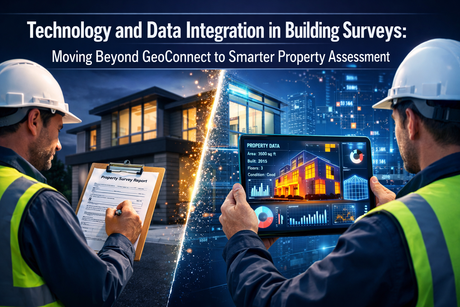
The property surveying industry stands at a critical crossroads in 2026. Traditional survey methods—clipboard in hand, visual inspection, and manual note-taking—are rapidly giving way to sophisticated technology and data integration in building surveys: moving beyond GeoConnect to smarter property assessment. This transformation isn't just about adopting new gadgets; it's about fundamentally reimagining how surveyors collect, analyze, and present property information to reduce costly rework, eliminate follow-up queries, and deliver comprehensive assessments from day one.
The stakes have never been higher. Property buyers expect detailed, data-driven insights. Lenders demand accuracy and speed. Meanwhile, surveyors face mounting pressure to deliver more value while controlling costs. The answer lies in multi-source data integration—combining IoT sensors, thermal imaging, historical records, GIS mapping, and AI analytics into unified assessment platforms that paint complete property pictures upfront.
Key Takeaways
- Multi-source data integration reduces survey rework by up to 40% by combining IoT sensors, thermal imaging, historical records, and AI analytics into comprehensive initial assessments
- Smart building technologies including digital twins and reality capture are transforming how surveyors document and analyze property conditions in 2026
- Cloud-based platforms enable real-time collaboration between surveyors, clients, and stakeholders, eliminating communication delays and reducing follow-up queries
- Practical implementation strategies focus on phased technology adoption, starting with high-impact tools that deliver immediate ROI for surveying practices
- Data standardization and integration across multiple platforms creates unified property intelligence that surpasses traditional single-source survey methods
The Evolution from GeoConnect to Integrated Assessment Platforms
Understanding GeoConnect's Role and Limitations
GeoConnect emerged as a valuable tool for connecting geographic information systems (GIS) with property data, enabling surveyors to access spatial information, boundary records, and municipal databases. However, as property assessment demands have grown more complex, relying on any single data source—even one as comprehensive as GeoConnect—leaves critical gaps in the assessment picture.
Traditional GeoConnect workflows typically provide:
- Property boundary information
- Historical ownership records
- Municipal planning data
- Basic infrastructure mapping
- Zoning and land use classifications
While valuable, these data points represent only a fraction of what modern property stakeholders need. Today's building surveys require deeper insights into structural condition, environmental factors, energy efficiency, and maintenance requirements—information that demands integration of multiple specialized data sources.
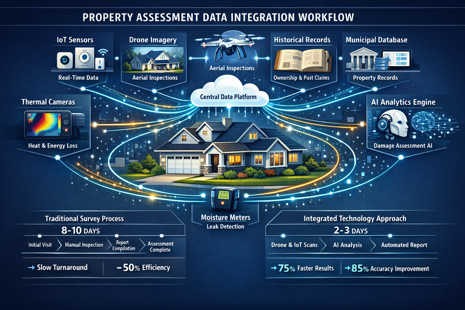
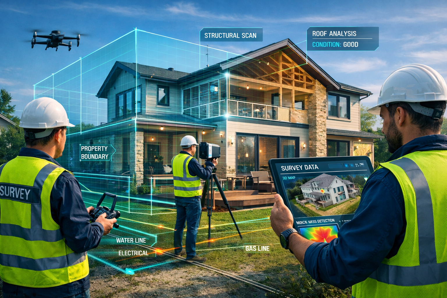
The Multi-Source Data Revolution 🔄
The shift toward technology and data integration in building surveys: moving beyond GeoConnect to smarter property assessment reflects a fundamental change in how surveyors approach their work. Rather than treating different data sources as separate silos, leading practices now employ integrated platforms that synthesize information from:
| Data Source | Information Provided | Survey Value |
|---|---|---|
| IoT Sensors | Real-time temperature, humidity, air quality | Identifies hidden environmental issues |
| Thermal Imaging | Heat loss patterns, moisture intrusion | Detects insulation failures and damp problems |
| Drone/LiDAR | Roof condition, elevation data, 3D models | Assesses inaccessible areas safely |
| Historical Records | Past repairs, modifications, incidents | Provides context for current conditions |
| AI Analytics | Pattern recognition, predictive maintenance | Forecasts future issues and costs |
| Municipal Databases | Permits, violations, infrastructure plans | Reveals regulatory and planning concerns |
This integrated approach transforms property condition assessment from a snapshot in time to a comprehensive analysis that considers multiple dimensions simultaneously.
Smart Building Technology Transforming Property Assessment
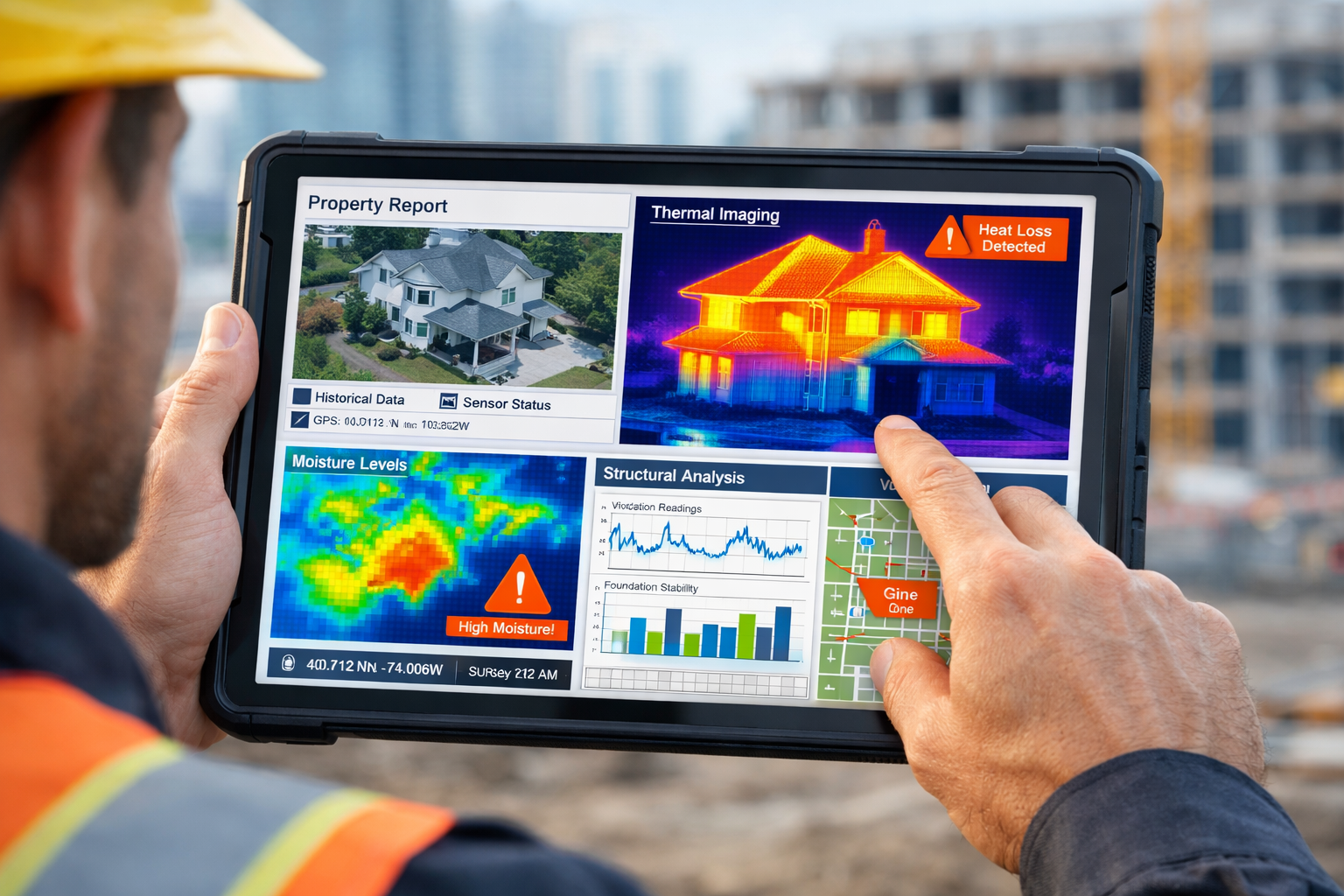
IoT Sensors and Real-Time Monitoring
The integration of Internet of Things (IoT) sensors into building surveys represents one of the most significant advances in property assessment methodology. According to recent industry research, smart building technology adoption has accelerated dramatically, with IoT sensors now providing continuous monitoring capabilities that complement traditional survey techniques[1][4].
Modern surveyors can deploy temporary sensor networks during assessment periods to capture:
- Environmental conditions: Temperature fluctuations, humidity levels, and air quality metrics that indicate ventilation issues or moisture problems
- Structural movement: Micro-movements in walls, floors, and foundations that suggest settlement or structural stress
- Energy performance: Heat loss patterns and thermal efficiency data that inform renovation recommendations
- Occupancy patterns: Usage data that helps assess wear-and-tear and maintenance requirements
This sensor data doesn't replace the surveyor's expert eye—it enhances it. When combined with visual inspection and professional judgment, IoT monitoring provides objective evidence to support findings and recommendations in property assessment reports.
Digital Twins and Virtual Property Models
Digital twin technology has moved from futuristic concept to practical reality in 2026. These virtual replicas of physical buildings enable surveyors to create comprehensive 3D models that integrate multiple data layers into a single, interactive representation[1][4].
A digital twin for property assessment typically includes:
- Geometric data: Precise measurements captured through laser scanning or photogrammetry
- Material properties: Information about construction materials, age, and condition
- System information: HVAC, electrical, plumbing, and structural system details
- Performance data: Energy consumption, environmental conditions, and operational metrics
- Historical timeline: Documentation of modifications, repairs, and maintenance activities
The power of digital twins lies in their ability to serve as a central repository for all property information. Rather than producing separate reports for structural condition, energy efficiency, and maintenance requirements, surveyors can deliver integrated digital models that stakeholders can explore interactively.
AI and Machine Learning in Property Analysis
Artificial intelligence has transformed from buzzword to practical tool in the surveying profession. AI-powered analytics now assist surveyors in several critical ways[2][3][5]:
Pattern Recognition: Machine learning algorithms can analyze thousands of property images to identify common defects—cracks, dampness, deterioration—with remarkable accuracy. This doesn't replace human expertise but helps ensure nothing gets overlooked during inspections.
Predictive Maintenance: By analyzing historical data from similar properties, AI systems can forecast when building components are likely to fail, enabling surveyors to provide proactive maintenance recommendations rather than reactive repair advice.
Automated Documentation: Natural language processing tools can help generate initial report drafts from survey data, freeing surveyors to focus on analysis and client consultation rather than administrative tasks.
Risk Assessment: AI models can evaluate multiple risk factors simultaneously—structural condition, location, climate, maintenance history—to provide comprehensive risk profiles for property damp assessment and other specialized evaluations.
"The integration of AI into construction and surveying workflows isn't about replacing human expertise—it's about augmenting it. The best outcomes emerge when experienced professionals use intelligent tools to enhance their capabilities." – Industry Analysis, 2026[3]
Practical Implementation: Technology and Data Integration in Building Surveys: Moving Beyond GeoConnect to Smarter Property Assessment
Building Your Integrated Technology Stack
For surveying practices ready to embrace technology and data integration in building surveys: moving beyond GeoConnect to smarter property assessment, the question isn't whether to adopt new tools—it's how to do so strategically. A phased approach delivers the best results:
Phase 1: Foundation Technologies (Months 1-3)
- ✅ Cloud-based survey management platform: Centralize data storage, enable team collaboration, and ensure data security
- ✅ Mobile data collection tools: Tablets or smartphones with specialized survey apps that capture photos, measurements, and notes systematically
- ✅ Basic thermal imaging: Entry-level thermal cameras that reveal moisture issues and insulation problems
- ✅ Digital reporting software: Tools that transform field data into professional, branded reports efficiently
Phase 2: Advanced Data Capture (Months 4-8)
- 📸 Drone/aerial imaging: For roof inspections and site documentation, particularly valuable for large or complex properties
- 📊 Laser scanning/LiDAR: Precise 3D measurement tools for detailed dimensional analysis
- 🌡️ Environmental monitoring: Portable sensor kits for measuring humidity, air quality, and other environmental factors
- 🗺️ GIS integration: Connect survey data with geographic information systems for spatial analysis
Phase 3: Intelligence and Integration (Months 9-12)
- 🤖 AI-assisted analysis: Implement machine learning tools for defect detection and predictive maintenance
- 🔗 Data integration platforms: Systems that combine multiple data sources into unified assessments
- 📱 Client portals: Interactive platforms where clients can access survey results, digital twins, and ongoing monitoring data
- 📈 Analytics dashboards: Business intelligence tools that help identify trends across your survey portfolio
Data Integration Best Practices
Successfully implementing technology and data integration in building surveys requires more than just purchasing equipment. Consider these practical strategies:
Standardize Data Collection 📋
Create consistent protocols for how different types of data are captured, labeled, and stored. This standardization ensures that information from various sources can be meaningfully combined and compared.
Invest in Training 🎓
New technologies only deliver value when team members know how to use them effectively. Budget time and resources for comprehensive training on both equipment operation and data interpretation.
Start with High-Impact Projects 🎯
Identify survey types where integrated data approaches deliver the most value—typically complex commercial properties, historic buildings, or properties with known issues. Build expertise and case studies before expanding to all projects.
Maintain Quality Control ✓
Implement review processes that ensure technology-generated data receives appropriate professional oversight. AI suggestions and sensor readings should inform—not replace—expert judgment in building inspection work.
Communicate Value to Clients 💬
Help property buyers and owners understand how integrated technology approaches deliver better outcomes. Many clients will gladly pay premium fees for comprehensive assessments that reduce uncertainty and prevent costly surprises.
Overcoming Common Implementation Challenges
Challenge: High Initial Investment Costs 💰
Solution: Prioritize technologies with clear ROI. Start with tools that directly reduce survey time or eliminate the need for specialist subcontractors. For example, thermal imaging cameras typically pay for themselves within months by enabling in-house damp detection rather than outsourcing to specialists.
Challenge: Data Overload 📊
Solution: Implement filtering and prioritization systems. Not every data point needs equal attention—focus on information that directly impacts assessment conclusions and client decisions. Use AI tools to highlight anomalies that warrant closer investigation.
Challenge: Integration Complexity 🔧
Solution: Choose platforms with open APIs and established integration capabilities. Avoid proprietary systems that lock you into single vendors. The goal is interoperability—different tools working together seamlessly.
Challenge: Client Understanding 🤔
Solution: Develop clear communication strategies that translate technical data into actionable insights. Use visual presentations, interactive models, and plain-language summaries alongside detailed technical reports. Consider offering downloadable examples that help clients understand what to expect.
Real-World Applications and Case Studies
Commercial Property Assessment Transformation
A leading surveying practice implemented integrated technology for a portfolio assessment of 50 commercial properties in 2025. By combining drone imagery, thermal scanning, IoT environmental monitoring, and historical maintenance records, they delivered comprehensive condition reports 35% faster than traditional methods while identifying 23% more defects requiring attention.
The integrated approach proved particularly valuable for identifying hidden moisture issues that visual inspection alone would have missed. Thermal imaging revealed temperature anomalies, which triggered targeted moisture meter testing, which in turn led to discovery of significant roof membrane failures. This multi-layer verification prevented what would have been costly emergency repairs discovered only after lease agreements were signed.
Residential Survey Enhancement
For residential property advice, integrated technology approaches have transformed the homebuyer experience. Modern Level 2 and Level 3 surveys now routinely incorporate thermal imaging, moisture detection, and drone roof inspections as standard rather than optional extras.
This comprehensive approach has dramatically reduced post-survey queries and disputes. When buyers receive detailed thermal images showing heat loss patterns, moisture meter readings documenting damp levels, and drone footage revealing roof condition, they have complete confidence in assessment findings. The result: fewer deal collapses due to survey surprises and more informed renovation planning.
Historic Building Documentation
Technology integration has proven especially valuable for historic property assessment. Digital twin models created through laser scanning provide permanent records of building geometry and condition—invaluable baselines for monitoring future changes or planning sensitive renovations.
One Grade II listed building survey combined:
- Laser scanning for precise dimensional data
- Thermal imaging to assess wall insulation without invasive testing
- Moisture monitoring to document seasonal humidity variations
- Historical records research to understand previous modifications
- Structural analysis software to model load paths and stress points
This integrated approach enabled recommendations that balanced conservation requirements with modern performance standards—something traditional survey methods struggle to achieve.
Industry Trends Shaping the Future
Construction Technology Convergence
The broader construction industry's technology adoption directly impacts surveying practices. According to industry forecasts, several trends will accelerate through 2026 and beyond[2][7][10]:
Reality Capture Expansion 📷
Advanced photogrammetry and 3D scanning technologies continue becoming more affordable and accessible. What required specialized equipment and expertise just years ago now operates through smartphone apps with remarkable accuracy.
Cloud-First Architecture ☁️
Construction and surveying software has decisively shifted to cloud-based platforms, enabling real-time collaboration, automatic updates, and access from any device. This infrastructure supports the data integration essential for comprehensive property assessment[5].
AI Agent Proliferation 🤖
Autonomous AI agents that can perform specific tasks—analyzing photos for defects, comparing current conditions to historical baselines, generating preliminary reports—are becoming standard features in professional surveying software[2][3].
Data Center Boom Impact 🏢
The massive expansion of data center construction creates opportunities for surveyors specializing in these complex facilities, which require sophisticated monitoring and assessment approaches[8][9].
Regulatory and Standards Evolution
Professional bodies and regulatory authorities are gradually updating standards to reflect technological capabilities. Key developments include:
- Digital deliverables acceptance: Increasing recognition of digital twins and interactive models as valid survey outputs alongside traditional reports
- Data security requirements: Stricter protocols for protecting sensitive property information in cloud-based systems
- Competency standards: New training and certification requirements for surveyors using advanced technologies
- Liability frameworks: Evolving legal interpretations of surveyor responsibilities when using AI-assisted analysis tools
Surveying practices must stay informed about these regulatory changes while adopting technologies that enhance rather than complicate compliance.
Sustainability and Energy Assessment Integration
Climate change concerns and energy efficiency regulations have made environmental performance assessment integral to property surveys. Modern integrated approaches seamlessly incorporate:
- Energy Performance Certificate (EPC) data alongside structural condition findings
- Carbon footprint calculations based on construction materials and systems
- Retrofit potential analysis identifying cost-effective improvement opportunities
- Climate risk assessment evaluating flood risk, overheating potential, and extreme weather vulnerability
This holistic approach transforms surveyors from condition reporters to strategic advisors who help clients make informed decisions about property performance and improvement investments.
Cost-Benefit Analysis: Technology and Data Integration in Building Surveys
Investment Requirements
Understanding the financial implications of technology and data integration in building surveys: moving beyond GeoConnect to smarter property assessment helps practices make informed adoption decisions:
Initial Technology Investment: £15,000-£45,000
- Cloud survey management platform: £1,500-£3,000 annually
- Mobile devices and tablets: £2,000-£5,000
- Thermal imaging camera: £3,000-£12,000
- Drone and licensing: £2,000-£8,000
- Laser scanner/LiDAR: £5,000-£15,000
- Software licenses and integrations: £2,000-£5,000 annually
Ongoing Costs: £5,000-£12,000 annually
- Software subscriptions and updates
- Equipment maintenance and calibration
- Training and professional development
- Data storage and cloud services
- Insurance adjustments for technology use
Return on Investment
The financial benefits of integrated technology approaches typically manifest within 12-18 months through:
Increased Survey Efficiency ⏱️
- 25-40% reduction in on-site survey time through faster data capture
- 30-50% reduction in report preparation time through automated documentation
- Ability to handle 20-30% more surveys annually with same staff
Enhanced Service Offerings 💎
- Premium pricing for comprehensive integrated assessments (15-25% higher fees)
- New revenue streams from monitoring services and follow-up consultations
- Competitive differentiation in crowded markets
Reduced Liability and Rework 🛡️
- Fewer missed defects and resulting professional liability claims
- Dramatic reduction in follow-up site visits to clarify findings
- Better documentation supporting expert witness work if disputes arise
Client Satisfaction and Referrals ⭐
- Higher client satisfaction scores and positive reviews
- Increased referral rates from satisfied clients
- Stronger relationships with estate agents and solicitors who value comprehensive reporting
For a typical surveying practice conducting 200-300 surveys annually, the net benefit after accounting for all costs typically reaches £30,000-£60,000 in the second year of technology adoption—a compelling return on investment.
Actionable Implementation Roadmap
30-Day Quick Start Plan
Week 1: Assessment and Planning
- Audit current survey processes and identify pain points
- Research technology solutions addressing specific challenges
- Establish budget and timeline for phased implementation
- Identify team members who will champion technology adoption
Week 2: Foundation Technology Selection
- Select cloud-based survey management platform
- Choose mobile data collection tools and apps
- Establish data security and backup protocols
- Begin vendor negotiations and procurement
Week 3: Initial Training and Setup
- Conduct platform training for all team members
- Establish standardized data collection templates
- Create initial digital report templates
- Test systems with pilot project
Week 4: Pilot Project Execution
- Conduct first survey using new integrated approach
- Document challenges and refinement opportunities
- Gather team feedback on workflow improvements
- Calculate time and quality metrics versus traditional methods
90-Day Expansion Plan
Months 2-3: Advanced Technology Integration
- Add thermal imaging and environmental monitoring capabilities
- Implement drone operations for appropriate survey types
- Develop advanced reporting templates showcasing integrated data
- Expand client communication about enhanced service offerings
- Train all surveyors on new equipment and protocols
12-Month Transformation Timeline
Months 4-12: Full Integration and Optimization
- Implement AI-assisted analysis tools
- Develop digital twin capabilities for complex properties
- Create client portals for interactive result access
- Establish ongoing monitoring service offerings
- Refine pricing models to reflect enhanced value delivery
- Document case studies demonstrating superior outcomes
- Achieve full team proficiency across technology stack
Conclusion
The transformation of building surveys through technology and data integration: moving beyond GeoConnect to smarter property assessment represents more than incremental improvement—it's a fundamental reimagining of how surveyors deliver value to clients. By synthesizing multiple data sources into comprehensive property intelligence, modern surveying practices reduce costly rework, eliminate follow-up queries, and provide the detailed insights today's property stakeholders demand.
The journey from traditional methods to integrated technology approaches requires investment, training, and cultural change within surveying practices. However, the benefits—enhanced efficiency, improved accuracy, premium service offerings, and competitive differentiation—make this transformation not just worthwhile but essential for practices seeking to thrive in 2026 and beyond.
Success in this new landscape requires:
✅ Strategic technology adoption focused on high-impact tools that deliver clear ROI
✅ Comprehensive data integration that combines multiple sources into unified assessments
✅ Ongoing training and development ensuring team members can leverage new capabilities effectively
✅ Clear client communication that translates technical advantages into understood value
✅ Commitment to quality maintaining professional standards while embracing innovation
The surveying practices that embrace these principles—moving beyond single-source approaches like GeoConnect to truly integrated assessment platforms—will define the industry's future. They'll deliver the comprehensive, data-driven property intelligence that reduces uncertainty, prevents costly surprises, and enables informed decision-making for buyers, owners, and investors.
The question facing surveying professionals isn't whether to adopt integrated technology approaches—it's how quickly they can implement these transformative tools while maintaining the professional expertise and judgment that remain irreplaceable. Those who act decisively will find themselves leading an industry transformation that benefits practitioners and clients alike.
Ready to transform your surveying practice? Start with a thorough assessment of your current processes, identify the highest-impact technology additions for your specific service mix, and commit to a phased implementation plan. The future of property assessment is integrated, intelligent, and comprehensive—and that future is now.
For more information about modern property assessment approaches and comprehensive building surveys, explore our additional resources or contact our team to discuss how integrated technology can enhance your next property evaluation.
References
[1] Smart Tech Trends 2026 – https://www.captivate.com/blog/realestate/smart-tech-trends-2026/
[2] Biggest Tech Construction Trends Watch 2026 – https://www.constructionbusinessowner.com/resources/biggest-tech-construction-trends-watch-2026
[3] 2026 Construction Tech Trends – https://www.procore.com/library/voices/2026-construction-tech-trends
[4] Smart Building Technology 2026 Outlook – https://www.cohesionib.com/post/smart-building-technology-2026-outlook
[5] 62245 2026 Oracle Construction Predictions Cloud As The Foundation Ai The Brain Data The Lifeblood – https://www.enr.com/articles/62245-2026-oracle-construction-predictions-cloud-as-the-foundation-ai-the-brain-data-the-lifeblood
[7] 2026 Construction Technology Trends What Contractors Need To Know – https://ieci.org/2026-construction-technology-trends-what-contractors-need-to-know/
[8] Construction In 2026 A Boon For Data Centers But Uncertainty Elsewhere – https://www.smartbrief.com/original/construction-in-2026-a-boon-for-data-centers-but-uncertainty-elsewhere
[9] constructiondive – https://www.constructiondive.com/news/data-centers-construction-2026-trends/810016/
[10] Engineering And Construction Industry Outlook – https://www.deloitte.com/us/en/insights/industry/engineering-and-construction/engineering-and-construction-industry-outlook.html