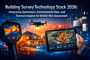
The surveying industry has undergone a dramatic transformation. What once required weeks of fieldwork, expensive equipment mobilization, and teams navigating hazardous terrain can now be accomplished in hours with advanced remote technologies. Remote Surveying Techniques: Reducing On-Site Visits with Drones and Digital Tools in 2026 represents not just an evolution in methodology, but a fundamental shift in how professionals approach land mapping, construction monitoring, and property assessment.
In 2026, the integration of artificial intelligence, LiDAR-equipped drones, and real-time kinematic GPS systems has elevated remote surveying from a convenient alternative to the industry standard. These technologies deliver centimeter-level accuracy while dramatically reducing costs, improving safety, and accelerating project timelines.[2][5] The post-pandemic world has accelerated adoption of these remote workflows, proving that physical presence on-site is no longer always necessary for high-quality surveying outcomes.
This comprehensive guide explores how Remote Surveying Techniques: Reducing On-Site Visits with Drones and Digital Tools in 2026 are reshaping professional practice across construction, mining, archaeology, infrastructure inspection, and property assessment sectors.
Key Takeaways
- 🚁 Drones equipped with RTK GPS and LiDAR sensors achieve centimeter-level accuracy, making them suitable for precision applications like boundary surveys and topographic mapping
- ⏱️ Time efficiency has transformed dramatically: drone surveys complete in hours what traditional methods required days or weeks to accomplish
- 🤖 AI-powered autonomous data collection enables real-time processing, automated flight planning, and intelligent feature detection without constant human oversight
- 💰 Operational costs are substantially lower than conventional surveying approaches, despite initial technology investment requirements
- 🛡️ Safety improvements are significant: drones eliminate crew exposure to hazardous terrain, active construction zones, and dangerous infrastructure
The Evolution of Remote Surveying Technology
From Traditional Methods to Digital Transformation
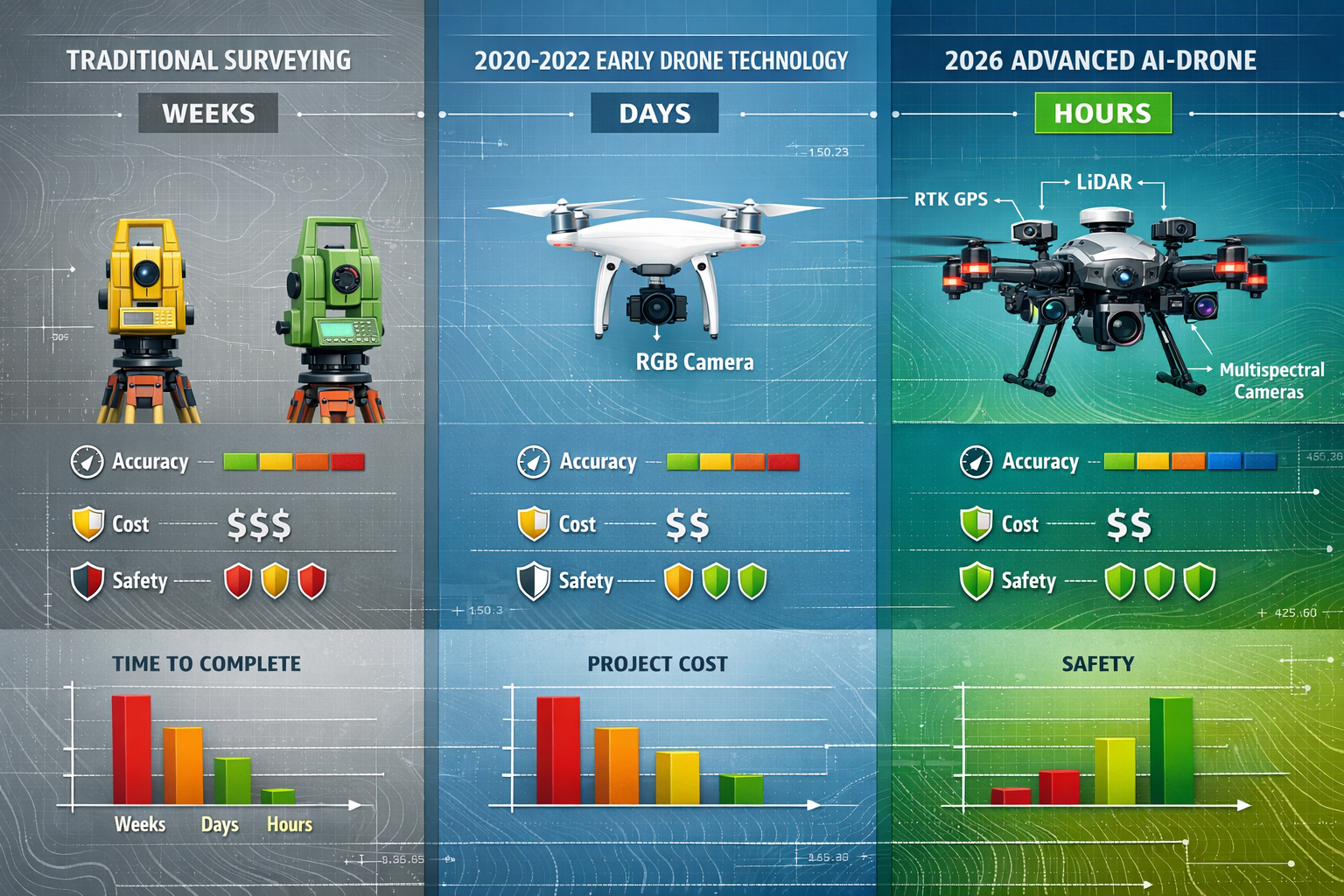
Traditional surveying methods have served the industry for centuries, relying on skilled professionals using theodolites, total stations, and GPS receivers to manually collect ground-based measurements. These approaches required extensive fieldwork, with surveyors physically accessing every measurement point regardless of terrain difficulty or environmental hazards.
The digital revolution began gradually with GPS technology in the 1990s, but the real transformation arrived with affordable commercial drone platforms in the mid-2010s. By 2026, drone-based surveying has transitioned from experimental technology to one of the pillars of modern aerial mapping.[4]
Key Technological Advances Driving Adoption
Several breakthrough technologies have converged to make Remote Surveying Techniques: Reducing On-Site Visits with Drones and Digital Tools in 2026 both practical and superior to traditional methods:
RTK GPS Integration: Real-Time Kinematic positioning systems now deliver centimeter-level accuracy in drone-captured data, eliminating the need for extensive ground control point networks.[2][5]
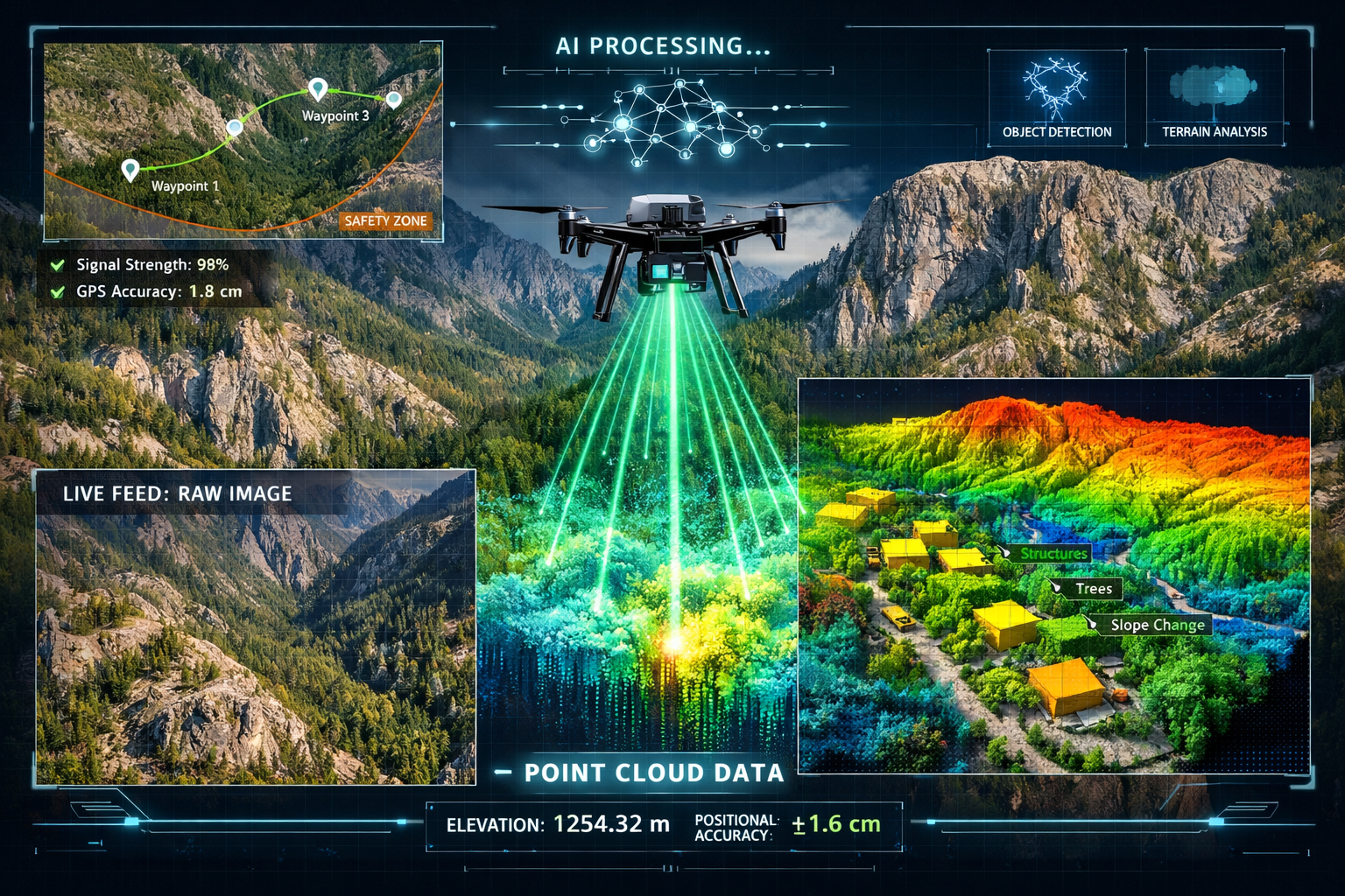
LiDAR Miniaturization: Light Detection and Ranging sensors, once restricted to aircraft and ground-based platforms, are now compact enough for drone deployment while maintaining the ability to penetrate dense vegetation and produce highly accurate 3D models.[1]
AI-Powered Automation: Artificial intelligence enables autonomous flight planning, real-time data processing, and intelligent feature detection, significantly reducing manual labor requirements.[2]
Multi-Sensor Platforms: Modern surveying drones carry LiDAR, calibrated RTK cameras, RGB cameras, and multispectral sensors, enabling one platform to support multiple use cases from construction monitoring to environmental assessment.[1][3]
Industry Integration and Workflow Standardization
According to Geo Week 2026 coverage, drone-based data collection has moved beyond being a "parallel track" to becoming fully integrated into industry-standard workflows. Companies now seamlessly blend piloted aircraft, drones, and terrestrial sensors, with photogrammetry software emphasizing interoperability between platforms.[4]
This integration means building surveyors can now incorporate drone-captured data alongside traditional inspection methods, creating comprehensive property assessments that combine aerial perspectives with detailed interior evaluations.
Core Technologies Enabling Remote Surveying in 2026
Drone Platforms and Sensor Systems
The foundation of modern remote surveying rests on sophisticated unmanned aerial systems equipped with specialized sensors. Understanding these technologies helps professionals select appropriate tools for specific applications.
Fixed-Wing vs. Multi-Rotor Platforms
| Platform Type | Best Applications | Coverage Area | Flight Time | Accuracy Level |
|---|---|---|---|---|
| Multi-rotor drones | Small sites, detailed inspection, vertical structures | Up to 200 acres | 20-45 minutes | ±1-3 cm with RTK |
| Fixed-wing drones | Large area mapping, linear infrastructure | 500+ acres | 45-90 minutes | ±2-5 cm with RTK |
| Hybrid VTOL | Medium to large sites, varied terrain | 200-800 acres | 60-120 minutes | ±1-4 cm with RTK |
LiDAR Technology Advantages
LiDAR (Light Detection and Ranging) uses laser measurements to create point cloud data representing terrain and structures. This technology has enabled archaeologists to discover new sites previously obscured by vegetation and allows surveyors to penetrate dense forest canopy to map ground surfaces.[1]
Key LiDAR benefits include:
- ✅ Vegetation penetration for accurate ground modeling
- ✅ High point density (100+ points per square meter)
- ✅ Consistent accuracy regardless of lighting conditions
- ✅ Ability to capture multiple returns per laser pulse
- ✅ Excellent performance in challenging terrain
Photogrammetry and RGB Imaging
While LiDAR excels at terrain modeling, high-resolution RGB cameras enable photogrammetric processing that creates detailed orthomosaics, digital surface models, and 3D reconstructions from overlapping photographs.[3]
Industrial drones generate multiple output formats in single flights, enabling surveyors to extract distances, volumes, elevations, and temporal changes without additional site visits.[3]
AI and Machine Learning Integration
Artificial intelligence has transformed remote surveying from a data collection exercise into an intelligent analysis platform. AI-powered drones now perform autonomous flight and real-time data processing, dramatically accelerating project timelines.[2]
AI applications in remote surveying include:
🤖 Autonomous Flight Planning: AI algorithms analyze terrain, weather conditions, and project requirements to optimize flight paths automatically
🤖 Real-Time Feature Detection: Machine learning models identify buildings, vegetation, infrastructure, and terrain features during data collection
🤖 Automated Quality Control: AI systems detect data gaps, poor image quality, or insufficient overlap before crews leave the field
🤖 Change Detection: Algorithms automatically compare survey data across time periods to identify modifications, construction progress, or environmental changes
🤖 Predictive Maintenance: AI analyzes infrastructure imagery to predict maintenance needs before failures occur
Geographic Information Systems (GIS) Integration
Modern remote surveying workflows integrate seamlessly with Geographic Information Systems (GIS), enabling professionals to combine drone-captured data with existing spatial databases, property records, and planning information.
This integration allows surveyors to deliver comprehensive spatial analysis rather than simple measurements, adding significant value to client deliverables.
Practical Applications of Remote Surveying Techniques
Construction Progress Monitoring and Quality Control
AI-enabled drones have revolutionized construction oversight by enabling real-time monitoring of construction progress through comparison of aerial data against design models to detect deviations and ensure quality control.[2][3]
Construction monitoring benefits:
- 📊 Weekly or daily progress documentation without disrupting site operations
- 📊 Automated volume calculations for earthwork verification and payment applications
- 📊 As-built verification comparing constructed elements against design specifications
- 📊 Safety compliance monitoring identifying hazards and unsafe conditions
- 📊 Stakeholder communication through visual progress reports and 3D models
For professionals conducting building surveys, drone data provides valuable context about site conditions, access constraints, and surrounding development that informs property assessments.
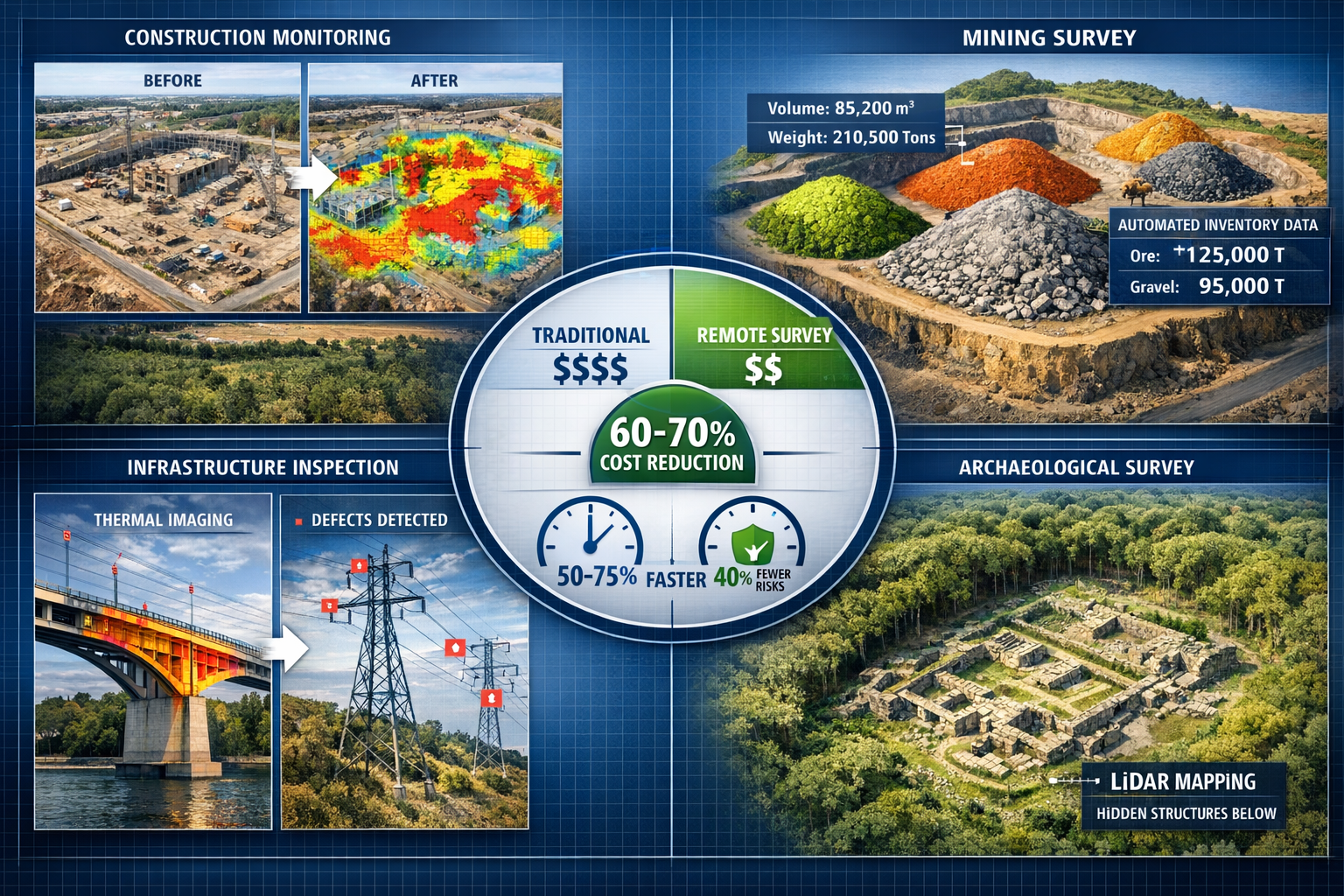
Mining and Quarry Operations
The mining and quarrying sectors have embraced remote surveying for operational efficiency and safety improvements. 3D mapping tools enable professionals to conduct automated volume calculations and inventory checks from drone data, supporting oversight work in these industries.[1]
Mining applications include:
- ⛏️ Stockpile volume measurement for inventory management
- ⛏️ Pit progression monitoring and planning
- ⛏️ Haul road condition assessment
- ⛏️ Slope stability analysis
- ⛏️ Environmental compliance documentation
Drones can survey large mining operations in a matter of hours compared to traditional ground-based surveying which requires days or even weeks for the same coverage.[1]
Infrastructure Inspection and Asset Management
Remote surveying techniques excel at inspecting difficult-to-access infrastructure including bridges, power lines, telecommunications towers, and pipelines. Drones eliminate the need for crews to work in steep terrain, active construction zones, or live infrastructure, reducing exposure to unnecessary risk while documenting hazardous locations.[3]
Infrastructure inspection advantages:
- 🔍 Close-range visual inspection without scaffolding or rope access
- 🔍 Thermal imaging to detect electrical hotspots or insulation failures
- 🔍 Detailed documentation of defects with precise GPS coordinates
- 🔍 Historical comparison tracking deterioration over time
- 🔍 Reduced inspection costs by 50-70% compared to traditional methods
Archaeological and Environmental Surveying
LiDAR technology has transformed archaeological research by revealing structures hidden beneath vegetation. This same capability supports environmental monitoring, forestry management, and ecological assessment.
Environmental applications benefit from multispectral sensors that capture data beyond visible light, enabling vegetation health analysis, water quality assessment, and habitat mapping.
Property Assessment and Boundary Surveys
While traditional property surveys still require some ground verification, remote surveying techniques significantly reduce on-site time requirements. RICS surveyors increasingly incorporate drone data into comprehensive property assessments, particularly for large estates, commercial properties, and sites with access challenges.
Drone surveys provide valuable information for homebuyers surveys by documenting roof conditions, drainage patterns, boundary features, and surrounding development without requiring extensive physical access.
Cost-Benefit Analysis: Remote vs. Traditional Surveying Methods
Understanding the Investment Requirements
Implementing Remote Surveying Techniques: Reducing On-Site Visits with Drones and Digital Tools in 2026 requires upfront investment in equipment, software, and training. However, operational costs for drone surveying are significantly lower than conventional surveying approaches.[1]
Initial investment components:
💰 Drone platform: £3,000-£25,000 depending on sensors and capabilities
💰 RTK/PPK GPS base station: £5,000-£15,000 for centimeter accuracy
💰 Processing software licenses: £1,500-£8,000 annually
💰 Training and certification: £2,000-£5,000 per operator
💰 Insurance coverage: £1,500-£4,000 annually
Operational Cost Comparisons
The true economic advantage becomes apparent when comparing operational costs per project:
| Survey Type | Traditional Method Cost | Remote Surveying Cost | Time Required (Traditional) | Time Required (Remote) |
|---|---|---|---|---|
| 50-acre topographic survey | £8,000-£12,000 | £2,500-£4,000 | 5-7 days | 4-6 hours |
| Construction progress monitoring | £3,500-£5,000 | £800-£1,500 | 2-3 days | 2-3 hours |
| Infrastructure inspection | £6,000-£10,000 | £1,500-£3,000 | 3-5 days | 3-5 hours |
| Boundary survey (10 acres) | £4,000-£6,000 | £1,200-£2,200 | 2-3 days | 3-4 hours |
These cost reductions stem from reduced field crew requirements, minimal equipment mobilization, faster data collection, and automated processing workflows.
Return on Investment Timeline
Most surveying firms implementing remote techniques achieve positive ROI within 12-18 months based on:
- ✔️ Ability to complete more projects with existing staff
- ✔️ Reduced travel and accommodation expenses
- ✔️ Lower insurance costs due to reduced field exposure
- ✔️ Competitive advantage in winning time-sensitive projects
- ✔️ Additional revenue from new service offerings
For firms conducting condition surveys, drone capabilities enable more comprehensive property documentation without proportional cost increases.
Hidden Value Beyond Direct Cost Savings
Beyond measurable cost reductions, remote surveying delivers additional value:
Safety improvements: Eliminating hazardous site access reduces injury risk and associated costs
Client satisfaction: Faster turnaround times and visual deliverables enhance client relationships
Data richness: Comprehensive 3D models support multiple analysis types from single data collection
Archive value: Historical drone data enables temporal analysis and change detection years later
Safety Advantages and Risk Reduction
Eliminating Hazardous Site Access
One of the most compelling advantages of Remote Surveying Techniques: Reducing On-Site Visits with Drones and Digital Tools in 2026 is the dramatic improvement in worker safety. Drones eliminate the need for surveyors to access:
⚠️ Steep or unstable terrain where falls present serious injury risk
⚠️ Active construction zones with moving equipment and overhead hazards
⚠️ Live electrical infrastructure including substations and transmission lines
⚠️ Contaminated sites with environmental or chemical hazards
⚠️ High-traffic roadways where ground crews face vehicle strike risk
⚠️ Unstable structures in demolition or deteriorated buildings
Quantifying Safety Improvements
Industry data shows that drone-based surveying reduces field crew exposure to hazardous conditions by 60-80% compared to traditional methods. This translates to:
- 📉 Fewer lost-time injuries requiring workers' compensation
- 📉 Reduced insurance premiums for surveying operations
- 📉 Lower liability exposure for firms and clients
- 📉 Improved employee retention and recruitment
- 📉 Enhanced corporate safety culture and compliance
For professionals conducting structural inspections, drones provide detailed visual documentation of roofs, chimneys, and upper-story elements without ladder access or scaffolding.
Regulatory Compliance and Documentation
Remote surveying techniques also improve safety documentation and regulatory compliance by:
✅ Creating permanent visual records of site conditions
✅ Enabling safety planning before crews access sites
✅ Documenting hazards for risk assessment
✅ Providing evidence of safety compliance
✅ Supporting incident investigation if accidents occur
Workflow Integration and Best Practices
Designing Effective Remote Surveying Workflows
Successfully implementing Remote Surveying Techniques: Reducing On-Site Visits with Drones and Digital Tools in 2026 requires thoughtful workflow design that integrates new technologies with existing processes.
Essential workflow components:
1. Pre-Flight Planning and Site Assessment
- Review project requirements and accuracy specifications
- Analyze airspace restrictions and obtain necessary authorizations
- Assess weather forecasts and optimal collection timing
- Plan ground control point locations if required
- Coordinate with site personnel and stakeholders
2. Data Collection Execution
- Deploy RTK base station or verify PPK reference data
- Execute autonomous flight missions with real-time monitoring
- Perform in-field quality checks of captured data
- Collect ground control measurements for verification
- Document collection parameters and conditions
3. Data Processing and Analysis
- Import raw data into photogrammetry or LiDAR processing software
- Generate point clouds, orthomosaics, and 3D models
- Perform quality control and accuracy verification
- Extract measurements, volumes, and feature data
- Apply AI-powered analysis for automated feature detection
4. Deliverable Preparation and Client Communication
- Export data in client-specified formats (CAD, GIS, PDF)
- Create visual reports with annotated imagery
- Prepare volumetric calculations and change detection analysis
- Deliver web-based 3D model viewers for stakeholder access
- Provide metadata documentation and accuracy statements
Combining Remote and Traditional Techniques
The most effective surveying workflows in 2026 blend remote and traditional techniques rather than completely replacing ground-based methods. This hybrid approach leverages the strengths of each methodology:
Remote techniques excel at:
- Large area coverage and initial site documentation
- Hazardous or difficult-to-access locations
- Visual inspection and condition assessment
- Temporal monitoring and change detection
- Stakeholder communication through visual deliverables
Traditional techniques remain essential for:
- Legal boundary establishment requiring monumentation
- Underground utility location and verification
- Detailed interior building surveys
- Precise control networks for large projects
- Verification of critical measurements
Chartered surveyors conducting comprehensive property assessments typically use drone data for exterior documentation and site context while performing traditional interior inspections for Level 2 surveys and detailed condition reporting.
Quality Control and Accuracy Verification
Maintaining quality standards requires systematic verification procedures:
Accuracy verification methods:
- ✓ Independent check measurements on known control points
- ✓ Comparison against existing survey data where available
- ✓ Statistical analysis of point cloud precision
- ✓ Peer review of processing parameters and outputs
- ✓ Client feedback and deliverable acceptance procedures
Data Management and Archive Strategies
Remote surveying generates substantial data volumes requiring organized management:
Best practices for data management:
- 📁 Standardized folder structures and naming conventions
- 📁 Metadata documentation for future reference
- 📁 Redundant backup systems (local and cloud-based)
- 📁 Version control for processed deliverables
- 📁 Long-term archive planning for historical analysis
Regulatory Considerations and Professional Standards
Drone Operation Regulations in 2026
Operating drones for commercial surveying requires compliance with aviation regulations that vary by jurisdiction. In the UK, the Civil Aviation Authority (CAA) establishes operational requirements including:
- 🛂 Operator registration and pilot competency certification
- 🛂 Operational authorization for specific flight categories
- 🛂 Airspace awareness and restriction compliance
- 🛂 Privacy and data protection considerations
- 🛂 Insurance coverage requirements
Professional Surveying Standards
While drone technology has advanced rapidly, professional standards for survey accuracy and deliverables remain unchanged. Surveyors must ensure that Remote Surveying Techniques: Reducing On-Site Visits with Drones and Digital Tools in 2026 meet the same quality benchmarks as traditional methods.
Key professional considerations:
RICS Standards Compliance: The Royal Institution of Chartered Surveyors maintains professional standards that apply regardless of collection methodology. RICS surveyors must ensure drone-based surveys meet appropriate accuracy specifications.
Accuracy Specifications: Different applications require different accuracy levels:
- Topographic mapping: ±5-10 cm typically acceptable
- Construction layout: ±2-3 cm required
- Boundary surveys: ±1-2 cm or better needed
- Volume calculations: ±3-5% accuracy standard
Professional Liability: Surveyors remain professionally liable for deliverables regardless of collection method, emphasizing the importance of quality control procedures.
Data Privacy and Security
Remote surveying raises privacy considerations that professionals must address:
- 🔒 Obtaining property owner consent for aerial data collection
- 🔒 Protecting sensitive client data during storage and transmission
- 🔒 Complying with GDPR and data protection regulations
- 🔒 Managing public privacy concerns in populated areas
- 🔒 Securing drone footage from unauthorized access
Future Developments and Emerging Technologies
Autonomous Surveying Systems
The trajectory of Remote Surveying Techniques: Reducing On-Site Visits with Drones and Digital Tools in 2026 points toward increasingly autonomous systems requiring minimal human intervention. Emerging developments include:
Fully Autonomous Operations: AI systems that plan missions, execute flights, process data, and deliver results with human oversight rather than constant control
Swarm Technology: Multiple drones working cooperatively to survey large areas simultaneously, dramatically reducing collection time
Persistent Monitoring: Automated systems conducting regular surveys on predetermined schedules, enabling continuous change detection
Edge Processing: Onboard AI processors analyzing data during flight, eliminating post-processing delays
Sensor Technology Advances
Next-generation sensors will expand remote surveying capabilities:
- 🔬 Hyperspectral imaging for detailed material identification
- 🔬 Ground-penetrating radar integration for subsurface mapping
- 🔬 Advanced thermal sensors for building performance analysis
- 🔬 Miniaturized LiDAR with higher point densities and longer ranges
- 🔬 Multi-sensor fusion combining complementary data streams automatically
Integration with Building Information Modeling (BIM)
The convergence of remote surveying with BIM workflows enables:
- Direct import of as-built data into BIM environments
- Automated comparison of constructed elements versus design intent
- Real-time construction progress tracking against project schedules
- Facilities management integration for lifecycle asset monitoring
Artificial Intelligence Evolution
AI capabilities will continue expanding to include:
Predictive Analytics: Forecasting maintenance needs, structural deterioration, and project risks based on survey data patterns
Automated Reporting: AI-generated survey reports with minimal human editing required
Intelligent Feature Extraction: Automatic identification and classification of site features, vegetation, infrastructure, and structures
Natural Language Queries: Conversational interfaces allowing clients to ask questions about survey data and receive automated responses
Overcoming Implementation Challenges
Technical Skill Development
Successfully adopting Remote Surveying Techniques: Reducing On-Site Visits with Drones and Digital Tools in 2026 requires developing new competencies:
Essential skills for remote surveying professionals:
📚 Drone piloting proficiency including emergency procedures and manual control
📚 Photogrammetry principles understanding image overlap, ground sampling distance, and processing parameters
📚 LiDAR technology knowledge including point cloud classification and accuracy assessment
📚 Software competency in processing platforms and CAD/GIS systems
📚 Data analysis skills for quality control and deliverable preparation
Training investment strategies:
- Manufacturer-provided training on specific platforms
- Professional development courses from surveying associations
- Online learning platforms for software skills
- Mentorship programs pairing experienced and new practitioners
- Incremental skill building through progressively complex projects
Managing Client Expectations
Educating clients about remote surveying capabilities and limitations ensures successful project outcomes:
Key client communication points:
✉️ Accuracy capabilities: Explaining what precision levels are achievable with different technologies
✉️ Weather dependencies: Clarifying how conditions affect data collection scheduling
✉️ Deliverable formats: Demonstrating output options and their applications
✉️ Timeline expectations: Setting realistic schedules for collection and processing
✉️ Cost structures: Explaining pricing based on area, complexity, and deliverables
For clients accustomed to traditional homebuyers reports, demonstrating how drone data enhances rather than replaces conventional inspection methods builds confidence in hybrid approaches.
Addressing Weather and Environmental Limitations
Remote surveying faces environmental constraints that require management strategies:
Weather considerations:
- ☁️ Wind speed limitations (typically 15-25 mph maximum)
- ☁️ Precipitation preventing flight operations
- ☁️ Lighting conditions affecting photogrammetric quality
- ☁️ Temperature extremes impacting battery performance
- ☁️ Seasonal vegetation affecting ground visibility
Mitigation approaches:
- Flexible scheduling with backup dates
- Multi-day weather windows for critical projects
- Seasonal planning for optimal collection timing
- LiDAR deployment for vegetation penetration needs
- Client communication about weather-related delays
Maintaining Equipment and Technology Currency
Remote surveying technology evolves rapidly, requiring ongoing investment:
Equipment lifecycle management:
- Regular maintenance and calibration procedures
- Replacement planning for aging platforms (3-5 year cycles)
- Software updates and subscription renewals
- Sensor calibration and accuracy verification
- Backup equipment for business continuity
Case Studies: Real-World Applications
Large-Scale Residential Development Monitoring
A major residential development in London required monthly progress monitoring across 45 acres with multiple active construction zones. Traditional surveying would have required 3-4 days of fieldwork monthly with significant safety concerns from active equipment.
Remote surveying solution:
- Monthly drone flights completed in 4 hours
- RTK-equipped multirotor capturing 2cm GSD imagery
- Automated processing generating orthomosaics and 3D models
- AI-powered change detection comparing monthly datasets
- Visual progress reports delivered to stakeholders within 48 hours
Results:
- 70% cost reduction compared to traditional monitoring
- Zero safety incidents from eliminated ground crew exposure
- Earlier identification of construction deviations
- Improved stakeholder communication through visual documentation
Historic Property Assessment
A Grade II listed estate required comprehensive condition assessment for property survey purposes, including detailed roof inspection and grounds documentation across 12 acres.
Hybrid surveying approach:
- Drone-based roof inspection eliminating scaffolding requirements
- Thermal imaging identifying heat loss and moisture issues
- Traditional interior inspection by chartered surveyors
- Grounds mapping documenting drainage, boundaries, and landscaping
- 3D model enabling virtual property tours for remote stakeholders
Results:
- £8,000 savings from eliminated scaffolding costs
- Comprehensive roof documentation without heritage fabric disturbance
- Thermal data identifying previously unknown insulation deficiencies
- Enhanced deliverable value through 3D visualization
Mining Operation Volume Verification
A quarry operation required monthly stockpile volume calculations for inventory management and sales verification across 200 acres.
Remote surveying implementation:
- Fixed-wing drone completing site coverage in 90 minutes
- Automated volume calculation software processing results
- Monthly temporal comparison tracking inventory changes
- Integration with operational management systems
- Accuracy verification against truck scale data
Results:
- 85% time reduction compared to manual surveying methods
- ±2% accuracy verified against physical measurements
- Improved operational planning from frequent data availability
- ROI achieved within 8 months of implementation
Conclusion: Embracing the Future of Surveying
Remote Surveying Techniques: Reducing On-Site Visits with Drones and Digital Tools in 2026 represents far more than technological innovation—it fundamentally reimagines how surveying professionals serve clients, manage projects, and ensure worker safety. The convergence of centimeter-accurate RTK positioning, vegetation-penetrating LiDAR sensors, AI-powered autonomous operations, and seamless workflow integration has created capabilities that were science fiction just a decade ago.[1][2][4]
The evidence is compelling: drone-based remote surveying delivers 60-80% cost reductions, completes projects in hours rather than weeks, eliminates hazardous site access, and produces richer datasets than traditional methods.[1][3] These advantages explain why remote techniques have transitioned from experimental approaches to industry-standard practice across construction, mining, infrastructure, and property assessment sectors.
Key Success Factors for Implementation
Organizations successfully implementing remote surveying share common characteristics:
✅ Strategic technology investment balancing capability needs with budget realities
✅ Comprehensive training programs developing technical competencies across teams
✅ Systematic quality control ensuring deliverables meet professional standards
✅ Hybrid workflows combining remote and traditional techniques appropriately
✅ Client education managing expectations and demonstrating value
✅ Continuous improvement adapting to evolving technologies and methodologies
Actionable Next Steps
For surveying professionals ready to embrace remote techniques:
1. Assess Current Capabilities and Gaps
- Evaluate which projects would benefit most from remote surveying
- Identify technical skill gaps requiring training investment
- Analyze equipment needs based on typical project requirements
- Review regulatory requirements for commercial drone operations
2. Start with Pilot Projects
- Select low-risk projects for initial remote surveying applications
- Partner with experienced providers for knowledge transfer
- Document lessons learned and refine workflows
- Build internal case studies demonstrating value
3. Invest in Training and Equipment
- Obtain necessary pilot certifications and operational authorizations
- Purchase or lease appropriate drone platforms and sensors
- Acquire processing software and develop competency
- Establish quality control procedures and verification methods
4. Develop Client Communication Strategies
- Create educational materials explaining remote surveying benefits
- Demonstrate deliverable examples and visualization capabilities
- Address common concerns about accuracy and reliability
- Highlight safety improvements and cost efficiencies
5. Plan for Continuous Evolution
- Monitor emerging technologies and capability improvements
- Participate in professional development and industry forums
- Evaluate workflow efficiency and identify optimization opportunities
- Stay current with regulatory changes and professional standards
The Competitive Imperative
In 2026, remote surveying capabilities are no longer optional differentiators—they're competitive necessities. Firms that fail to adopt these techniques face disadvantages in project timelines, cost competitiveness, safety performance, and service offerings. Conversely, organizations embracing Remote Surveying Techniques: Reducing On-Site Visits with Drones and Digital Tools in 2026 position themselves for sustained success in an increasingly technology-driven industry.
The transformation of surveying practice through remote technologies demonstrates how digital innovation enhances rather than replaces professional expertise. The most successful practitioners combine cutting-edge data collection methods with traditional surveying knowledge, professional judgment, and client service excellence.
Whether conducting building surveys, monitoring construction progress, assessing infrastructure condition, or documenting property boundaries, remote surveying techniques offer compelling advantages that benefit professionals and clients alike. The future of surveying is here—and it's flying overhead, capturing centimeter-accurate data, and revolutionizing how the built and natural environment is measured, analyzed, and understood.
References
[1] Drone Surveying – https://uavcoach.com/drone-surveying/
[2] Ai Drones For Surveying Enhancing Land Mapping Precision And Efficiency – https://www.arcsurveyors.com/ai-drones-for-surveying-enhancing-land-mapping-precision-and-efficiency/
[3] Drones For Surveying And Mapping – https://acecoretechnologies.com/drones-for-surveying-and-mapping/
[4] Drones Transformed Photogrammetry Geo Week 2026 – https://www.commercialuavnews.com/drones-transformed-photogrammetry-geo-week-2026
[5] Drone For Mapping – https://www.jouav.com/blog/drone-for-mapping.html