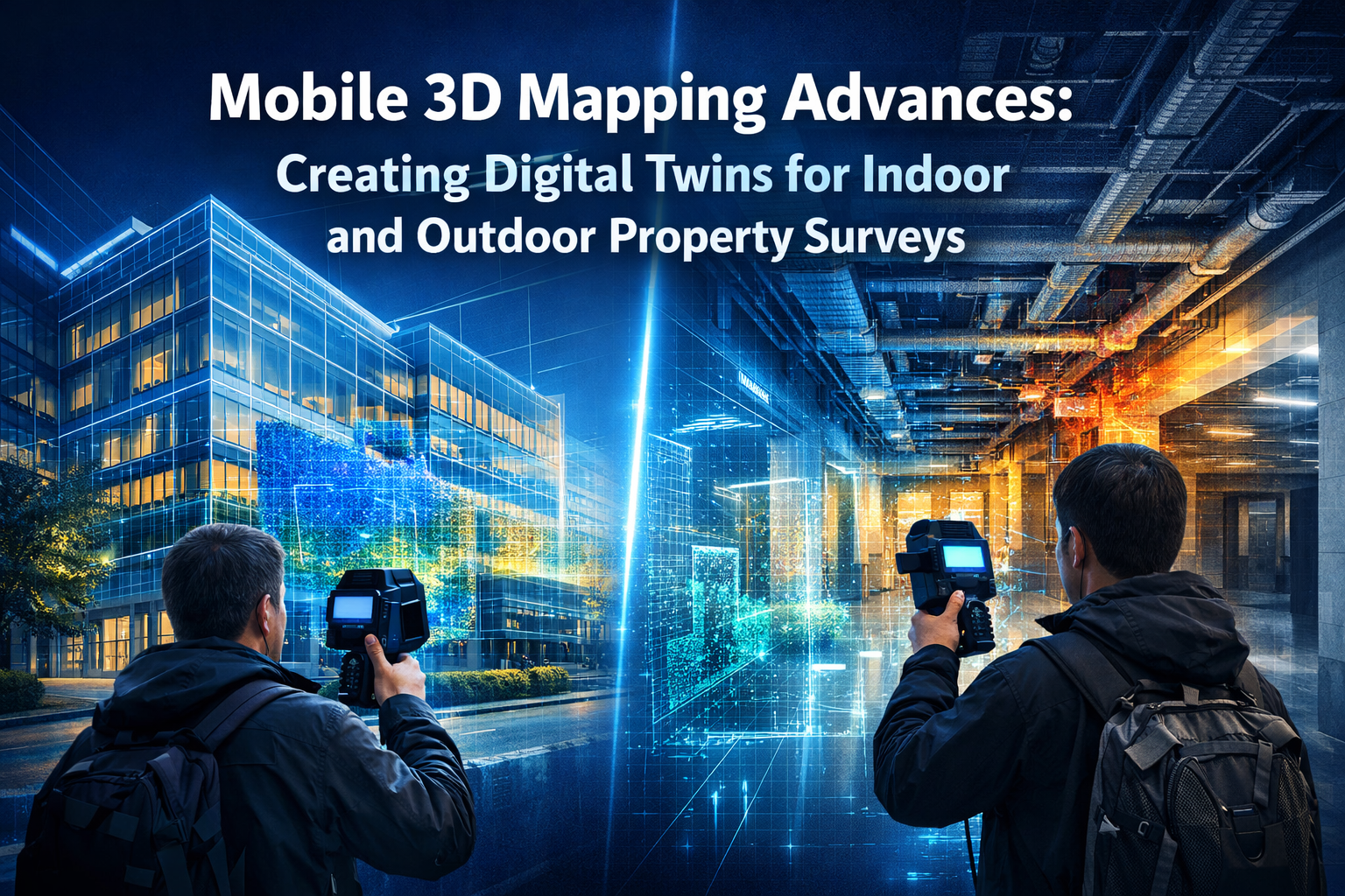
Picture this: A surveyor walks through a sprawling commercial property with nothing more than a backpack-mounted scanner, capturing millions of data points per second. Within hours, a complete digital replica of the entire facility—inside and out—exists in the cloud, ready for analysis, planning, and decision-making. This isn't science fiction. Mobile 3D Mapping Advances: Creating Digital Twins for Indoor and Outdoor Property Surveys represent one of the most transformative shifts in property assessment technology in decades.
Gone are the days when property surveys required bulky equipment, multiple site visits, and weeks of processing time. Today's mobile mapping systems combine lightweight sensors, advanced cameras, and sophisticated software to generate detailed 3D models quickly and accurately. These digital twins are revolutionizing how professionals approach everything from routine property inspections to complex urban development projects.
The technology has evolved from theoretical applications to active deployment across industries. Whether assessing a residential property for potential buyers or mapping an entire city block for infrastructure planning, mobile 3D mapping delivers unprecedented detail and efficiency. The digital twin market is projected to reach $45 billion by 2026, with approximately $25 billion in total addressable market for the geospatial industry[8].
Key Takeaways
- 📱 Portable Power: Modern mobile mapping systems use handheld, backpack, and wearable devices that capture complex environments quickly without bulky traditional survey equipment
- 🎯 Sub-Centimeter Accuracy: Advanced systems achieve exceptional precision for property surveys, enabling remote analysis and detailed defect identification
- ⚡ Speed Advantage: Mobile mapping completes property surveys in hours instead of days, reducing site visit costs and project timelines by up to 70%
- 🏢 Facility-Ready Output: Digital twins now integrate directly with operational systems, supporting asset management, work orders, and space utilization planning
- 🔒 Built-In Compliance: Modern systems include automated anonymization and security protocols for sensitive environments and regulatory requirements
Understanding Digital Twins in Property Surveying

What Are Digital Twins?
A digital twin is a virtual replica of a physical asset, space, or system that mirrors its real-world counterpart in remarkable detail. In property surveying, digital twins go far beyond simple 3D models or photographs. They capture precise spatial relationships, surface textures, structural elements, and environmental conditions in a format that supports measurement, analysis, and simulation.
Think of a digital twin as a living, interactive copy of a building or property. Professionals can navigate through spaces virtually, take measurements, identify defects, and plan modifications—all without returning to the physical site. This capability transforms how property surveys are conducted and utilized.
The Evolution from Static to Dynamic Models
Traditional property surveys produced static documentation: floor plans, elevation drawings, and written reports. While valuable, these documents captured a single moment in time and required interpretation to understand spatial relationships.
Digital twins have transitioned from theoretical applications to active deployment in urban planning, factory operations, and construction project delivery[1]. Modern systems now integrate real-time data feeds from traffic sensors, condition monitoring systems, and environmental sensors with geospatial data to create living models that support predictive maintenance and virtual scenario testing[3].
This evolution is particularly valuable for commercial property inspections where ongoing monitoring and analysis provide long-term value beyond the initial survey.
Key Components of Property Digital Twins
Effective digital twins for property surveys combine several essential elements:
| Component | Purpose | Benefit |
|---|---|---|
| Point Cloud Data | Captures millions of spatial coordinates | Provides foundation for accurate measurements |
| Textured 3D Models | Adds visual realism to geometric data | Enables defect identification and material assessment |
| Metadata Integration | Links assets, spaces, and systems | Supports facility management and planning |
| GIS Integration | Connects to geographic information systems | Enables spatial analysis and urban planning |
| Real-Time Updates | Incorporates sensor and monitoring data | Supports predictive maintenance and scenario testing |
Mobile 3D Mapping Technology Fundamentals
Hardware Systems Driving the Revolution
Mobile 3D Mapping Advances: Creating Digital Twins for Indoor and Outdoor Property Surveys rely on three primary hardware configurations, each optimized for different scenarios:
Handheld Scanners like the BLK2GO offer maximum flexibility for navigating tight spaces and complex interiors. These devices combine rotating LiDAR sensors with visual cameras, allowing surveyors to walk naturally through properties while capturing comprehensive data. They're ideal for residential surveys and smaller commercial properties.
Wearable Systems such as the NavVis VLX3 mount on backpacks, freeing both hands and enabling longer scanning sessions. These systems integrate cameras, LiDAR, and GNSS positioning on platforms that balance comfort with capability[1]. They excel at large facility surveys where extended scanning sessions are necessary.
Robotic Platforms including quadruped robots access areas too dangerous or restricted for human surveyors. These autonomous systems navigate construction sites, industrial facilities, and hazardous environments while maintaining consistent data quality.
The Scan2Twin methodology developed by geoConvergence combines three reality capture methods: NavVis VLX3 wearable systems, BLK2GO handheld scanners, and robotic quadrupeds for accessing restricted spaces[2]. This multi-platform approach ensures comprehensive coverage regardless of property complexity.
Sensor Integration and Data Capture
Modern mobile mapping systems orchestrate multiple sensors simultaneously to build comprehensive digital twins:
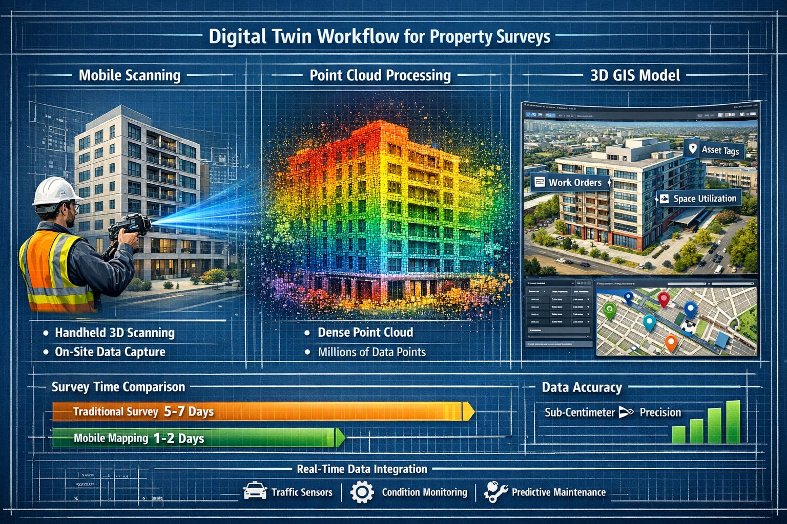
LiDAR (Light Detection and Ranging) emits laser pulses and measures return times to calculate precise distances. This creates dense point clouds with millions of spatial coordinates. Mobile LiDAR systems can capture 300,000 to 700,000 points per second, ensuring complete coverage even when moving through spaces quickly.
High-Resolution Cameras capture visual information that adds context and detail to geometric data. Multi-camera arrays positioned around mobile mapping devices ensure complete coverage without blind spots. High-resolution camera systems reduce interpolation errors during photogrammetry by providing richer raw input for algorithms[1].
GNSS/GPS Receivers provide geographic positioning for outdoor surveys, anchoring digital twins to real-world coordinates. This integration is essential for urban planning and infrastructure projects.
IMU (Inertial Measurement Units) track device orientation and movement, helping software understand the scanner's position and trajectory as it moves through space. This data is critical for accurate point cloud registration.
Processing Pipelines: From Raw Data to Digital Twin
Captured data flows through sophisticated processing pipelines that transform millions of raw measurements into usable digital twins. Understanding this workflow helps appreciate the technology's capabilities.
Photogrammetry Pipelines analyze overlapping images to reconstruct 3D geometry. Software identifies common features across multiple photographs, calculates their spatial positions, and generates textured 3D models. This process benefits from high-resolution cameras and proper multi-camera synchronization, which prevents temporal drift and frame mismatches when combining data from multiple sensors[1].
SLAM (Simultaneous Localization and Mapping) algorithms solve a fundamental challenge: building a map while simultaneously determining the scanner's position within that map. SLAM processes LiDAR and visual data in real-time, continuously refining both the 3D model and the device's trajectory through space.
Data flows through photogrammetry and SLAM pipelines to generate dense point clouds and textured 3D models[1]. Modern systems can process data automatically, delivering preliminary results within hours of completing fieldwork.
Mobile 3D Mapping Advances: Creating Digital Twins for Property Surveys
Speed and Efficiency Advantages
One of the most compelling benefits of Mobile 3D Mapping Advances: Creating Digital Twins for Indoor and Outdoor Property Surveys is the dramatic reduction in survey time. Mobile mapping captures complex environments quickly with fewer field passes compared to static survey methods, reducing project timelines and site visit costs[1].
Consider a typical commercial property survey:
Traditional Method:
- Multiple site visits over 3-5 days
- Static laser scanning from 20-30 fixed positions
- Manual photography and note-taking
- 2-3 weeks processing and report generation
- Limited ability to revisit or verify measurements
Mobile Mapping Method:
- Single site visit lasting 2-4 hours
- Continuous scanning while walking through property
- Automatic data capture and synchronization
- 2-3 days processing with preliminary results same-day
- Complete digital twin available for unlimited virtual revisits
This efficiency translates directly to cost savings. Fewer site visits mean lower travel expenses, reduced disruption to property occupants, and faster project delivery. For structural surveys requiring detailed analysis, the ability to capture comprehensive data in a single visit is invaluable.
Accuracy and Precision Standards
Speed means nothing without accuracy. Modern mobile mapping systems achieve sub-centimeter accuracy for infrastructure analysis and property surveys[3]. This precision enables remote road safety audits, hazard detection, and detailed defect identification without physical measurements.
Several factors contribute to this exceptional accuracy:
Sensor Quality: Professional-grade LiDAR sensors and cameras capture data with minimal noise and maximum resolution. Higher point densities and better image quality directly improve final model accuracy.
Calibration Protocols: Regular calibration ensures sensors maintain accuracy over time. Professional systems include automated calibration routines and verification procedures.
Registration Algorithms: Advanced software aligns multiple scans and images with sub-millimeter precision, ensuring the final digital twin maintains accuracy throughout.
Ground Control Points: For projects requiring absolute accuracy, surveyors can establish reference points with known coordinates, allowing software to optimize the entire digital twin against verified measurements.
This level of precision makes mobile 3D mapping suitable for applications previously requiring traditional surveying methods, including specific defect surveys and monitoring surveys tracking structural changes over time.
Indoor and Outdoor Versatility
Mobile 3D Mapping Advances: Creating Digital Twins for Indoor and Outdoor Property Surveys excel in both environments, adapting seamlessly to different conditions:
Indoor Applications:
- Residential property surveys for homebuyers
- Commercial facility documentation
- Heritage building preservation
- Interior space planning and renovation design
- As-built documentation for construction projects
- Lease documentation and dilapidations assessments
Outdoor Applications:
- Building exterior condition assessment
- Site planning and development analysis
- Urban infrastructure mapping
- Transportation corridor surveys
- Landscape documentation
- Property boundary verification
The same mobile system that captures a building's interior can immediately transition to documenting its exterior and surrounding site. This continuity ensures complete property coverage without switching equipment or methodologies.
Applications in Property Assessment and Surveying
Residential Property Surveys
For homebuyers and property owners, digital twins created through mobile 3D mapping offer unprecedented insight into property condition. A comprehensive homebuyers survey can now include an interactive 3D model alongside traditional reporting.
Benefits for Residential Surveys:
🏠 Complete Documentation: Every room, surface, and structural element captured in detail
📏 Accurate Measurements: Virtual measurements of rooms, ceiling heights, and features without physical access
🔍 Defect Identification: Visual documentation of cracks, damp, settlement, and other issues
📊 Comparative Analysis: Ability to compare property condition over time with repeat scans
💰 Negotiation Support: Detailed evidence for price negotiations based on identified defects
The technology supports different survey levels, from basic condition assessments to comprehensive Level 3 structural surveys, with digital twins providing the foundation for detailed analysis.
Commercial Property and Facility Management
Commercial properties benefit even more dramatically from digital twin technology. Scan2Twin delivers facility-ready digital twins structured around assets, work orders, and space use rather than visualization alone, enabling immediate operational application[2].
Commercial Applications Include:
Asset Management: Link equipment, systems, and building components to their precise locations within the digital twin. Maintenance teams can locate assets instantly and access service history, specifications, and documentation.
Space Utilization: Analyze how spaces are used, identify inefficiencies, and plan reconfigurations. Digital twins support workplace optimization and tenant fit-out planning.
Lease Documentation: Create accurate as-built records for lease agreements and dilapidations assessments. The digital twin provides objective documentation of property condition at lease commencement and termination.
Renovation Planning: Architects and contractors can work directly from the digital twin, reducing site visits and improving design accuracy. Clash detection identifies conflicts before construction begins.
Emergency Planning: First responders can familiarize themselves with building layouts, access routes, and hazard locations through virtual walkthroughs.
Urban Planning and Infrastructure
At the urban scale, Mobile 3D Mapping Advances: Creating Digital Twins for Indoor and Outdoor Property Surveys support comprehensive city planning and infrastructure management. Entire neighborhoods, transportation corridors, and public spaces can be captured and analyzed digitally.
Infrastructure analysis using digital twins can achieve sub-centimeter accuracy for remote road safety audits and hazard detection[3]. Transportation agencies use digital twins to:
- Assess road surface conditions and identify maintenance needs
- Plan infrastructure improvements and expansions
- Simulate traffic flow and test design alternatives
- Document existing conditions before construction projects
- Monitor structural health of bridges and tunnels
A recent project demonstrated this capability by mapping a new town with 3D digital twin technology, creating a comprehensive baseline for future development[4].
Integration with Existing Surveying Workflows
Complementing Traditional Survey Methods
Mobile 3D mapping doesn't replace traditional surveying—it enhances and accelerates it. Professional surveyors integrate mobile mapping with established methodologies to deliver more comprehensive services.
Traditional surveys excel at:
- Establishing precise legal boundaries
- Providing expert interpretation and recommendations
- Conducting invasive investigations when necessary
- Offering professional opinions on defects and risks
Mobile 3D mapping adds:
- Comprehensive visual documentation
- Detailed spatial measurements
- Interactive client presentations
- Long-term reference models for future comparison
The combination provides clients with both expert analysis and detailed documentation. A RICS Homebuyer Survey can include a digital twin alongside the surveyor's report, giving buyers both professional assessment and the ability to virtually revisit the property.
GIS and BIM Integration
Modern digital twins integrate seamlessly with Geographic Information Systems (GIS) and Building Information Modeling (BIM) platforms. This interoperability ensures digital twins become working tools rather than isolated visualizations.
GIS Integration connects property-level digital twins to broader geographic context. Surveyors can analyze properties in relation to:
- Flood zones and environmental hazards
- Transportation networks and accessibility
- Utility infrastructure and services
- Zoning regulations and planning constraints
- Neighboring properties and development patterns
BIM Integration supports construction and renovation projects by providing accurate as-built conditions. Architects and engineers can:
- Design renovations based on precise existing conditions
- Identify structural elements and systems
- Coordinate new construction with existing buildings
- Generate accurate quantity takeoffs and cost estimates
- Detect clashes between proposed and existing elements
The Scan2Twin methodology specifically targets this integration, delivering digital twins that work within existing GIS and asset management platforms[2].
Data Management and Accessibility
Digital twins generate substantial data volumes—a comprehensive property scan can produce gigabytes of point cloud data and hundreds of high-resolution images. Effective data management ensures this information remains accessible and useful.
Cloud-Based Platforms provide:
- Centralized storage accessible from anywhere
- Collaborative access for multiple stakeholders
- Automated backup and version control
- Integration with analysis and visualization tools
- Scalable storage as project requirements grow
Security Considerations are paramount, especially for sensitive properties. Systems support automated anonymization and HIPAA compliance for Personally Identifiable Information (PII) protection in sensitive environments[2]. This capability is essential for healthcare facilities, government buildings, and properties where privacy is critical.
Long-Term Archiving ensures digital twins remain valuable for years. Property owners can compare current conditions against historical scans, tracking changes, deterioration, or improvements over time. This longitudinal data supports monitoring surveys and condition assessments.
Overcoming Challenges and Limitations
Environmental and Lighting Conditions
While mobile 3D mapping works in diverse conditions, certain environments present challenges:
Low Light Situations: Indoor spaces with minimal lighting can affect camera-based photogrammetry. However, LiDAR sensors function independently of lighting, ensuring geometric data capture continues. Some systems include integrated lighting to supplement ambient conditions.
Reflective Surfaces: Glass, mirrors, and polished metals can confuse both LiDAR and cameras. Experienced operators recognize these challenges and adjust scanning approaches accordingly, sometimes applying temporary coatings to highly reflective surfaces.
Outdoor Weather: Rain, snow, and fog affect outdoor scanning accuracy. Professional projects schedule fieldwork during favorable conditions or use weather-resistant systems designed for challenging environments.
GNSS Interference: Indoor environments and urban canyons can block GPS signals. Modern systems rely on SLAM algorithms and visual positioning to maintain accuracy when GNSS is unavailable.
Data Processing Requirements
The processing pipeline from raw scans to finished digital twins requires significant computational resources:
Processing Time: While faster than traditional methods, processing still takes hours to days depending on project size and desired output quality. Cloud-based processing services accelerate this timeline by distributing computational work across multiple servers.
Technical Expertise: Operating mobile mapping systems and processing data requires training. Professional surveyors invest in education and certification to ensure quality results.
Software Costs: Professional processing software represents a significant investment. However, the efficiency gains and expanded service offerings typically justify these costs for established surveying practices.
Quality Control and Verification
Ensuring digital twin accuracy requires systematic quality control:
Field Verification: Experienced operators verify scan coverage during fieldwork, ensuring no areas are missed and data quality meets requirements.
Registration Checks: Processing software includes tools to verify point cloud alignment and identify registration errors. Operators review these metrics to ensure accuracy standards are met.
Measurement Validation: Comparing digital twin measurements against known dimensions or traditional survey measurements validates accuracy.
Client Review: Providing clients access to preliminary digital twins allows them to identify missing areas or request additional detail before final delivery.
Future Trends in Mobile 3D Mapping for Property Surveys
Artificial Intelligence and Automated Analysis
The next frontier in Mobile 3D Mapping Advances: Creating Digital Twins for Indoor and Outdoor Property Surveys involves artificial intelligence that automatically identifies and classifies features within digital twins.
AI-Powered Defect Detection will automatically identify:
- Cracks in walls and foundations
- Damp and moisture damage
- Structural settlement and movement
- Material deterioration
- Building code violations
This automation will accelerate survey reporting and ensure consistent defect identification across projects. Surveyors will focus on interpreting findings and providing recommendations rather than manually documenting every defect.
Automated Asset Recognition will catalog building components, systems, and equipment without manual tagging. AI will recognize HVAC units, electrical panels, plumbing fixtures, and structural elements, automatically populating facility management databases.
Real-Time Processing and Edge Computing
Current workflows involve post-processing after fieldwork completion. Emerging technologies enable real-time processing during scanning:
On-Device Processing using powerful mobile processors and edge computing will provide immediate feedback to operators. Surveyors will see preliminary digital twins forming as they scan, identifying coverage gaps and quality issues before leaving the site.
Immediate Client Access will allow stakeholders to view developing digital twins remotely while scanning continues. This transparency improves communication and ensures client requirements are met.
Miniaturization and Accessibility
Mobile mapping systems continue becoming smaller, lighter, and more affordable:
Smartphone Integration: Advanced smartphones already include LiDAR sensors. While not yet matching professional system accuracy, consumer devices enable basic digital twin creation for simple properties.
Wearable Sensors: Future systems may integrate into standard safety equipment or clothing, making scanning an automatic byproduct of property visits rather than a dedicated activity.
Democratized Access: As costs decrease, more surveyors and property professionals will adopt mobile 3D mapping, making digital twins standard rather than premium offerings.
Enhanced Interoperability and Standards
Industry standards for digital twin data formats and exchange protocols will improve interoperability:
Universal Formats: Standardized file formats will ensure digital twins work across different software platforms and applications without conversion or data loss.
API Integration: Application programming interfaces will connect digital twins to diverse systems—from facility management software to property valuation platforms.
Blockchain Verification: Distributed ledger technology may provide tamper-proof verification of digital twin authenticity and accuracy, supporting legal and regulatory applications.
Practical Implementation for Surveying Professionals
Selecting Appropriate Systems
Surveying professionals considering mobile 3D mapping should evaluate systems based on their specific needs:
Project Types: Residential surveyors may prioritize handheld systems for maneuverability, while commercial specialists might need wearable systems for larger facilities.
Accuracy Requirements: Different applications demand different precision levels. Understanding client needs and regulatory requirements guides system selection.
Budget Considerations: Systems range from consumer-grade smartphone solutions to professional platforms costing tens of thousands. Starting with mid-range systems and expanding as demand grows provides a balanced approach.
Training and Support: Vendor training programs and ongoing technical support ensure successful implementation. Choosing systems with strong user communities and educational resources accelerates learning.
Building Client Demand
Educating clients about digital twin benefits drives adoption:
Demonstration Projects: Offering digital twins as value-added services on select projects demonstrates capabilities and generates referrals.
Visual Communication: Showing clients interactive digital twins is far more compelling than describing the technology. Creating portfolio examples showcases possibilities.
Competitive Differentiation: In competitive markets, offering advanced services like digital twins distinguishes forward-thinking surveying practices from traditional competitors.
Value Proposition: Emphasizing time savings, comprehensive documentation, and long-term value helps clients understand why digital twins justify investment.
Regulatory and Professional Standards
Professional surveyors must ensure mobile 3D mapping work meets regulatory requirements:
RICS Standards: The Royal Institution of Chartered Surveyors provides guidance on incorporating new technologies while maintaining professional standards. Digital twins should complement, not replace, professional judgment and reporting.
Data Protection: Compliance with data protection regulations (GDPR, etc.) requires careful handling of property information and images that may include personal data.
Professional Indemnity: Insurance coverage should explicitly include mobile 3D mapping activities and digital twin deliverables.
Documentation Standards: Maintaining clear documentation of scanning methodologies, accuracy verification, and processing procedures supports professional accountability.
Case Studies and Real-World Applications

Urban Development Preview
A major urban development project utilized mobile 3D mapping to create a comprehensive digital twin of an entire neighborhood slated for redevelopment. The digital twin enabled:
- Stakeholder Engagement: Community members virtually explored proposed changes and provided feedback
- Design Optimization: Architects tested multiple design alternatives within the accurate existing context
- Heritage Preservation: Historical buildings were documented in detail before any construction began
- Infrastructure Planning: Utility companies coordinated new services based on precise existing conditions
The project demonstrated how Mobile 3D Mapping Advances: Creating Digital Twins for Indoor and Outdoor Property Surveys support complex, multi-stakeholder projects requiring extensive coordination.
Commercial Facility Management
A large corporate campus implemented digital twins for ongoing facility management. Mobile mapping captured all buildings, creating a comprehensive baseline. The facility management team now:
- Tracks asset locations and maintenance history within the 3D environment
- Plans renovations and space reconfigurations using accurate as-built data
- Conducts virtual site visits with contractors before projects begin
- Monitors building condition through periodic re-scanning and comparison
The digital twin reduced facility management costs by 25% while improving service quality and response times.
Residential Survey Enhancement
A surveying practice integrated mobile 3D mapping into their residential survey services. Clients receive traditional survey reports alongside interactive digital twins. Benefits include:
- Enhanced Client Satisfaction: Buyers appreciate comprehensive documentation and virtual access
- Reduced Callbacks: Clients can virtually measure and verify details without requesting additional site visits
- Marketing Differentiation: The practice attracts clients specifically seeking advanced survey services
- Efficiency Gains: Single site visits capture all necessary data, reducing survey costs and timelines
Client feedback indicates digital twins significantly improve understanding of property conditions compared to traditional reports alone.
Conclusion
Mobile 3D Mapping Advances: Creating Digital Twins for Indoor and Outdoor Property Surveys represent a fundamental shift in how property professionals capture, analyze, and communicate spatial information. The technology has matured from experimental applications to reliable, accurate tools that enhance traditional surveying methodologies.
The benefits are clear and compelling:
✅ Dramatic time savings through rapid data capture and reduced site visits
✅ Exceptional accuracy meeting professional surveying standards
✅ Comprehensive documentation providing long-term reference value
✅ Enhanced client communication through interactive, visual deliverables
✅ Operational integration supporting facility management and planning
As the digital twin market continues its projected growth toward $45 billion by 2026[8], property surveying professionals who adopt these technologies position themselves at the forefront of industry evolution. The question is no longer whether to incorporate mobile 3D mapping, but how quickly to implement it and which applications will provide the greatest value.
Actionable Next Steps
For surveying professionals ready to embrace mobile 3D mapping:
-
Research Available Systems: Evaluate handheld, wearable, and robotic platforms based on your typical project requirements and budget
-
Invest in Training: Pursue vendor certification programs and professional development courses focused on mobile mapping and digital twin creation
-
Start Small: Implement digital twins on select projects to build expertise and demonstrate value before full-scale adoption
-
Educate Clients: Develop clear communication materials explaining digital twin benefits and applications relevant to your market
-
Establish Workflows: Integrate mobile mapping into existing survey processes, developing standard operating procedures for data capture, processing, and delivery
-
Monitor Technology Evolution: Stay informed about AI integration, processing advances, and emerging applications that may expand service offerings
-
Join Professional Networks: Connect with other surveyors implementing mobile 3D mapping to share experiences and best practices
The future of property surveying increasingly involves digital twins created through mobile 3D mapping. Those who adapt and innovate will lead the profession forward, delivering unprecedented value to clients while building sustainable, competitive practices.
Whether conducting a detailed homebuyers report, assessing commercial facilities, or supporting urban development, mobile 3D mapping provides the tools to work faster, more accurately, and more comprehensively than ever before.
The technology is ready. The market is growing. The opportunity is now.
References
[1] 3d Mobile Mapping For Digital Twins Camera Features That Ensure Accuracy – https://www.e-consystems.com/blog/camera/applications/3d-mobile-mapping-for-digital-twins-camera-features-that-ensure-accuracy/
[2] Geoconvergence Introduces Scan2twin Mobile Mapping For Digital Twin Creation Gis Integration – https://www.geoweeknews.com/news/geoconvergence-introduces-scan2twin-mobile-mapping-for-digital-twin-creation-gis-integration
[3] Mapping The Future Of Digital Twins Transforming Transportation Cad To Gis – https://sanborn.com/blog/mapping-the-future-of-digital-twins-transforming-transportation-cad-to-gis/
[4] Mapping A New Town With 3d Digital Twin Technology – https://www.gim-international.com/content/news/mapping-a-new-town-with-3d-digital-twin-technology
[5] Digital Twins For Event Planning In 2026 Predictive Simulations To Eliminate Surprises – https://www.ticketfairy.com/blog/digital-twins-for-event-planning-in-2026-predictive-simulations-to-eliminate-surprises/
[6] WordPress – https://gaeatech.com/wordpress/?p=537
[7] 2026 Industrial Digital Reality Summit – https://www.industrialdigitalreality.com/2026-industrial-digital-reality-summit
[8] Wgic Policy Report 2022 01 Spatial Digital Twins – https://wgicouncil.org/wp-content/uploads/2023/11/WGIC-Policy-Report-2022-01-Spatial-Digital-Twins.pdf