Property owners face a crucial question when planning construction projects, resolving boundary disputes, or purchasing land: how much will a land survey actually cost? Understanding Land Survey Costs in 2026: Price Trends, Technology's Impact, and Budget Planning for Property Owners has become increasingly important as the surveying industry undergoes significant technological transformation while navigating modest inflationary pressures.
The landscape of land surveying has evolved dramatically over the past few years. While traditional surveying methods remain foundational, cutting-edge technologies like GPS systems, drone mapping, and LiDAR scanning have revolutionized how professionals measure and document property boundaries. These innovations initially increase service costs but promise greater accuracy and long-term value for property owners.
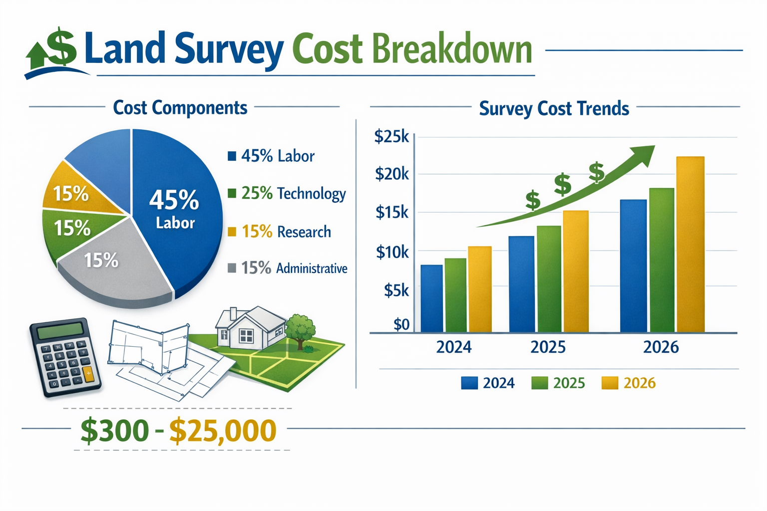
In 2026, the national average for land surveys in the United States stands at approximately $2,300, though actual costs range dramatically from $475 to $25,000 depending on numerous factors[3]. Basic residential surveys typically fall between $300 and $1,200, while complex commercial or large-acreage surveys can exceed $2,000[1]. Understanding these pricing dynamics helps property owners budget effectively and make informed decisions about when and how to invest in professional surveying services.
Key Takeaways
📊 Average survey costs in 2026 range from $300 for basic residential properties to over $25,000 for complex commercial surveys, with a national average of $2,300[3]
🚁 Technology investments in GPS, drones, and LiDAR initially raise survey prices but deliver superior accuracy, faster turnaround times, and comprehensive digital documentation
📍 Location significantly impacts pricing, with urban areas charging $1,500+ for basic surveys compared to $350-$650 in rural regions[1][3]
🏘️ Property characteristics like lot shape, size, terrain complexity, and availability of existing records can add $50 to $1,000+ to base survey costs[3]
💡 Strategic planning and understanding pricing factors help property owners budget effectively and select the right survey type for their specific needs
Understanding Current Land Survey Pricing Structures in 2026
The cost of land surveys in 2026 reflects a complex interplay of traditional surveying fundamentals and modern technological capabilities. Property owners need to understand how surveyors calculate fees and what factors drive pricing variations across different regions and property types.
National Average Costs and Regional Variations
The national average land survey cost has settled at $2,300 in 2026, representing a modest increase from previous years driven primarily by inflation and rising operational expenses[3]. However, this figure masks significant regional variations that property owners must consider when budgeting.
Urban versus rural pricing disparities remain substantial:
- Metropolitan areas (New York, San Francisco, Los Angeles): $1,500+ for basic residential surveys[1]
- Suburban regions: $550-$1,100 for standard properties[3]
- Rural areas: $350-$650 for comparable surveys[3]
These differences stem from several factors, including higher operational costs in cities, increased demand for surveying services in developing areas, and the complexity of navigating dense property records in established urban centers.
| Survey Type | Price Range | Typical Use Case |
|---|---|---|
| Basic Boundary Survey | $300-$1,200 | Residential property lines |
| Topographic Survey | $800-$2,500 | Construction planning |
| ALTA/NSPS Survey | $2,000-$5,000 | Commercial transactions |
| Subdivision Survey | $5,000-$25,000+ | Land development |
| Mortgage Survey | $350-$600 | Home purchase verification |
Property-Specific Cost Factors
Several property characteristics directly influence survey costs, creating significant price variations even within the same geographic region.
Lot shape complexity plays a surprisingly important role in pricing:
- Rectangular lots: $380-$750 baseline cost[3]
- Irregular lots with multiple sides: $580-$950[3]
- Each additional side beyond a basic rectangle adds approximately $50[3]
Property size naturally affects costs, as larger parcels require more time, equipment deployment, and boundary marker placement. A quarter-acre suburban lot might cost $500 to survey, while a 10-acre rural property could easily exceed $2,000.
Terrain complexity significantly impacts pricing:
- Flat, cleared land: baseline pricing
- Hills and slopes: 15-25% premium
- Wooded areas: 20-35% premium
- Properties with water bodies: 25-50% premium
These premiums reflect the additional time required to navigate challenging terrain, the need for specialized equipment, and the increased difficulty of establishing accurate measurements in complex environments.
Research and Documentation Requirements
One of the most overlooked cost drivers involves the research intensity required before fieldwork even begins. When existing property records are missing, outdated, or inaccurate, surveyors must invest considerable time reconstructing property history through deed research, courthouse visits, and neighboring property analysis.
Research-intensive surveys can add $500 to $1,000 to baseline costs[3]. This premium reflects:
- Hours spent reviewing historical deeds and plat maps
- Travel to county offices and record repositories
- Analysis of conflicting boundary descriptions
- Coordination with neighboring property surveys
- Resolution of discrepancies in historical records
Property owners can potentially reduce these costs by gathering available documentation before engaging a surveyor, including previous survey plats, property deeds, title insurance documents, and any correspondence regarding boundary disputes.
For property owners seeking professional surveyor services, understanding these baseline cost structures helps set realistic budget expectations and facilitates more productive conversations with surveying firms.
Technology's Impact on Land Survey Costs in 2026
The surveying industry has undergone a technological revolution that fundamentally changed how professionals measure, document, and deliver survey data. Understanding how these innovations affect Land Survey Costs in 2026: Price Trends, Technology's Impact, and Budget Planning for Property Owners requires examining both the initial investment costs and the long-term value proposition.
Modern Surveying Equipment and Initial Cost Increases
The land survey equipment market has experienced substantial growth, with the global market expanding significantly as firms invest in advanced technologies[5]. This equipment modernization has created upward pressure on survey costs, particularly for firms that have recently upgraded their capabilities.
Key technologies driving cost changes include:
🛰️ GPS and GNSS Systems: Modern Real-Time Kinematic (RTK) GPS systems provide centimeter-level accuracy but represent significant capital investments for surveying firms. These costs are partially passed to clients through service fees.
🚁 Drone Technology: Unmanned aerial vehicles equipped with high-resolution cameras and sensors enable rapid data collection over large areas. While drone surveys can reduce field time by 50-70%, the equipment, licensing, and specialized training required create initial cost premiums[6].
📡 LiDAR Scanning: Light Detection and Ranging technology captures millions of data points to create detailed 3D models of properties. This technology delivers unprecedented accuracy but requires substantial equipment investments and specialized expertise.
💻 Advanced Software Systems: Modern surveying relies on sophisticated software for data processing, CAD drafting, and 3D modeling. Annual licensing fees and training costs contribute to operational expenses.
The future of land surveying technology in 2026 emphasizes integration of these systems to deliver comprehensive property data that extends far beyond traditional boundary markers[6]. Property owners benefit from detailed topographic information, digital terrain models, and precise measurements that support construction planning and development decisions.
Long-Term Value and Efficiency Gains
While technology investments initially increase survey costs, they deliver substantial long-term benefits that often justify premium pricing:
Accuracy improvements reduce the likelihood of costly boundary disputes and construction errors. Modern GPS systems achieve accuracy within 1-2 centimeters, compared to 5-10 centimeters for traditional methods[6]. This precision prevents expensive mistakes during construction and provides stronger legal documentation for property boundaries.
Faster turnaround times mean property owners receive survey results in days rather than weeks. Drone surveys that might have required a week of traditional fieldwork can now be completed in hours, with data processing following shortly after.
Comprehensive digital deliverables provide ongoing value beyond the initial survey. Property owners receive:
- High-resolution aerial imagery
- 3D topographic models
- CAD files compatible with architectural software
- Digital boundary files for GPS marking
- Comprehensive documentation for future reference
Cost comparison example:
| Survey Method | Initial Cost | Accuracy | Turnaround | Digital Assets |
|---|---|---|---|---|
| Traditional | $800 | ±5-10 cm | 2-3 weeks | Basic plat map |
| Technology-Enhanced | $1,200 | ±1-2 cm | 3-5 days | Full digital package |
The $400 premium for technology-enhanced surveys often proves worthwhile when considering the superior accuracy, faster project timelines, and comprehensive documentation provided.
Market Trends and Equipment Investment
The land survey equipment market is projected to continue growing as surveying firms recognize the competitive advantages of technological capabilities[8]. This ongoing investment cycle creates interesting market dynamics:
Established firms that have already absorbed technology costs may offer competitive pricing as they amortize equipment investments across numerous projects. Newer firms or those recently upgrading may charge premium rates to recoup capital expenditures more quickly.
Property owners can sometimes benefit from this dynamic by:
- Requesting quotes from multiple firms with varying technology adoption levels
- Understanding which technological capabilities their specific project actually requires
- Timing surveys during slower periods when firms offer competitive rates
The land surveying industry continues evolving, with 2026 representing a maturation point where technology adoption has become standard rather than exceptional. This normalization gradually reduces the technology premium as equipment costs are distributed across larger project volumes.
Breaking Down Price Trends: Why Survey Costs Have Increased Modestly
Understanding the modest cost increases in land surveying requires examining multiple economic factors that have influenced the industry over recent years. Land Survey Costs in 2026: Price Trends, Technology's Impact, and Budget Planning for Property Owners reflect these broader economic trends while remaining relatively stable compared to other professional services.
Inflation and Operational Cost Pressures
Inflation has exerted steady upward pressure on survey costs throughout the early 2020s, though the surveying industry has experienced more modest increases than many other sectors. Several operational cost categories have contributed to overall price trends:
Labor costs represent the largest expense for surveying firms, typically accounting for 40-50% of total project costs. Professional surveyors require extensive education, licensing, and ongoing training. As wages have increased across professional services, surveying firms have adjusted pricing accordingly.
Fuel and transportation expenses significantly impact survey costs, particularly for rural or large-acreage projects. Field crews must travel to sites, often with heavy equipment, and may need to make multiple visits for complex surveys. Fuel price fluctuations directly affect operational budgets.
Insurance and licensing costs have risen steadily, reflecting the professional liability risks surveyors assume. Errors and omissions insurance, general liability coverage, and professional licensing fees all contribute to overhead expenses that must be recovered through project pricing.
Equipment maintenance and calibration ensures surveying instruments maintain required accuracy standards. Modern electronic equipment requires regular calibration, software updates, and occasional replacement of components, creating ongoing operational expenses.
Despite these pressures, base prices for standard residential surveys have not dramatically changed from 2024-2025 levels[1]. The industry has largely absorbed inflationary pressures through efficiency improvements and technological capabilities that enable surveyors to complete more projects in less time.
Specialized Services and Premium Pricing
While basic boundary surveys have experienced modest price increases, specialized surveying services have become increasingly expensive due to technological advancements and evolving regulatory requirements[1].
Specialized survey types commanding premium pricing:
🏗️ ALTA/NSPS Surveys: These comprehensive surveys meet stringent standards required for commercial real estate transactions, incorporating boundary determination, improvements location, easements documentation, and zoning compliance verification. Costs typically range from $2,000 to $5,000 or more.
🌍 Topographic Surveys: Detailed elevation and terrain mapping for construction planning requires extensive data collection and processing. Modern topographic surveys utilizing LiDAR and drone technology range from $800 to $2,500 for residential properties.
🏘️ Subdivision Surveys: Land development projects requiring platting, utility easements, and regulatory compliance documentation can cost $5,000 to $25,000+ depending on parcel count and complexity.
🔬 Soil and Geotechnical Surveys: When combined with engineering analysis, these specialized surveys range from £750 to £12,500 (approximately $950 to $15,800 USD) in the UK market[2], with similar pricing structures in the US.
The premium pricing for specialized services reflects not only the additional fieldwork required but also the professional liability assumed by surveyors. These surveys often form the foundation for significant financial decisions or construction projects, creating higher stakes for accuracy and completeness.
Supply and Demand Dynamics
Regional demand and supply factors heavily influence pricing, with high-demand periods and areas commanding premium rates[1]. Understanding these market dynamics helps property owners time their survey needs strategically.
High-demand scenarios that increase costs:
- Real estate booms: Increased property transactions create surges in survey demand
- Construction seasons: Spring and summer months see higher demand for construction-related surveys
- Development activity: Areas experiencing rapid growth often face surveyor shortages
- Regulatory changes: New zoning or building requirements can trigger survey demand spikes
Lower-cost opportunities may arise during:
- Winter months in northern climates (weather permitting)
- Economic slowdowns reducing transaction volumes
- Areas with multiple competing surveying firms
- Off-peak periods for specific survey types
The surveying industry in 2026 has experienced renewed demand following pandemic-related disruptions, with firms reporting strong project pipelines driven by continued real estate activity and infrastructure development[4]. This sustained demand supports current pricing levels while preventing significant cost reductions.
Property owners seeking property assessment services should recognize that survey costs represent a relatively small percentage of total property transaction or construction costs. A $1,000 survey on a $500,000 property represents just 0.2% of the transaction value while providing critical legal protection and construction planning data.
Budget Planning Strategies for Property Owners in 2026

Effective budget planning for land surveys requires understanding not only current pricing but also strategic approaches to obtaining maximum value from surveying investments. Property owners who approach surveys strategically can optimize costs while ensuring they receive the comprehensive data needed for their specific situations.
Determining Which Survey Type You Actually Need
One of the most effective cost-control strategies involves selecting the appropriate survey type for your specific needs rather than defaulting to the most comprehensive (and expensive) option.
Common survey types and appropriate use cases:
Boundary Survey ($300-$1,200): Ideal for:
- Fence installation planning
- Resolving minor boundary questions
- Property line verification before landscaping
- Basic property understanding for homeowners
Mortgage/Location Survey ($350-$600): Appropriate for:
- Residential property purchases
- Refinancing requirements
- Title insurance purposes
- Basic improvement location verification
Topographic Survey ($800-$2,500): Necessary for:
- Construction planning and design
- Drainage and grading analysis
- Architectural project development
- Engineering studies
ALTA/NSPS Survey ($2,000-$5,000+): Required for:
- Commercial property transactions
- Complex title situations
- Lender requirements for commercial properties
- Comprehensive easement documentation
Many property owners over-purchase surveying services by requesting comprehensive surveys when simpler options would suffice. Conversely, some underestimate their needs and later require additional surveys to address gaps in initial documentation.
Questions to ask when determining survey needs:
✅ What specific questions do you need answered?
✅ Are there lender or title company requirements?
✅ Will construction or development follow the survey?
✅ Do local regulations mandate specific survey types?
✅ Are there known boundary disputes or easement questions?
Consulting with surveying firms about appropriate survey types for your situation often reveals cost-effective options that still meet your actual needs. Similar to understanding what surveyors do, knowing which services you require prevents unnecessary expenses.
Cost-Saving Strategies Without Compromising Quality
Several legitimate strategies can reduce survey costs while maintaining professional quality and accuracy:
1. Gather Existing Documentation
Providing surveyors with previous survey plats, property deeds, title commitments, and any historical boundary documentation can reduce research time by several hours, potentially saving $200-$500 on research-intensive projects.
2. Prepare the Property
Clearing vegetation along suspected boundary lines, marking known monuments or corners, and ensuring site access can reduce field time. While surveyors will verify and establish official boundaries, preliminary preparation can streamline their work.
3. Schedule Strategically
Requesting surveys during slower periods (typically late fall through early spring in many regions) may result in more competitive pricing as firms seek to maintain steady workflow.
4. Bundle Multiple Services
If you need both a boundary survey and topographic information, requesting combined services from a single firm often costs less than separate engagements.
5. Request Multiple Quotes
Obtaining proposals from 2-4 reputable surveying firms allows price comparison while understanding service variations. However, the lowest price doesn't always represent the best value—consider firm reputation, technology capabilities, and turnaround time.
6. Understand What's Included
Some survey quotes include only basic deliverables, while others provide comprehensive digital files, multiple copies, and detailed documentation. Comparing quotes requires understanding exactly what each firm provides.
7. Consider Long-Term Value
Investing in comprehensive digital deliverables during the initial survey may cost slightly more but provides ongoing value for future construction, property modifications, or boundary verifications.
Regional Considerations and Local Resources
Property location significantly influences both costs and available resources for surveying services. Property owners in different regions should consider location-specific factors when budget planning.
Urban property owners in areas like Camden, Wandsworth, or Kingston typically face higher survey costs but benefit from:
- Multiple competing surveying firms
- Faster turnaround times due to proximity
- Advanced technology adoption
- Specialized expertise for complex urban properties
Suburban property owners in regions like Ealing, Hounslow, or Barnet often find:
- Moderate pricing between urban and rural rates
- Good availability of surveying services
- Balanced technology and traditional methods
- Reasonable turnaround times
Rural property owners may experience:
- Lower base pricing for standard surveys
- Premiums for travel and mobilization
- Longer scheduling timelines
- Potential challenges with complex terrain
Understanding these regional dynamics helps property owners set realistic expectations and identify the most cost-effective local resources for their surveying needs.
Creating a Comprehensive Survey Budget
Property owners should approach survey budgeting as part of overall project planning rather than as an isolated expense. A comprehensive budget framework includes:
Base Survey Cost: The quoted price for surveying services
Contingency Reserve (10-15%): Buffer for unexpected complications like difficult terrain access, weather delays, or additional research requirements
Related Costs:
- Property line marking or monument installation
- Copies and certifications for multiple parties
- Rush fees if accelerated timelines are needed
- Follow-up consultations or site visits
Opportunity Costs:
- Project delays if survey reveals boundary issues
- Potential construction modifications based on survey findings
- Time investment in reviewing and understanding survey results
A $1,500 survey might actually require a $1,800-$2,000 budget allocation when accounting for these additional factors. This realistic budgeting prevents surprises and ensures adequate resources for complete project execution.
For property owners undertaking significant projects, survey costs should be considered alongside other professional services like property condition assessments and structural evaluations to create a comprehensive due diligence budget.
Navigating Survey Selection and Vendor Evaluation
Selecting the right surveying firm represents a critical decision that extends beyond simple price comparison. The quality, accuracy, and completeness of survey work can significantly impact property transactions, construction projects, and legal protections.
Evaluating Surveying Firms and Proposals
Professional surveying requires technical expertise, proper licensing, and professional liability insurance. Property owners should evaluate potential surveyors across multiple dimensions:
Professional Qualifications:
- State licensure and registration status
- Professional association memberships (NSPS, state societies)
- Years of experience and specialization areas
- Continuing education and technology training
Technology Capabilities:
- Equipment inventory and technology adoption
- Digital deliverable options
- Software compatibility for CAD files
- Data accuracy specifications
Business Practices:
- Professional liability insurance coverage
- Client references and testimonials
- Project timeline commitments
- Communication and responsiveness
Proposal Completeness:
- Detailed scope of work description
- Specific deliverables listed
- Timeline and milestone commitments
- Payment terms and schedule
- Warranty or guarantee provisions
The most comprehensive proposals clearly articulate what will be surveyed, how fieldwork will be conducted, what research will be performed, and exactly what the client will receive upon completion.
Understanding Survey Deliverables and Documentation
Modern surveys provide far more than simple paper plats. Understanding deliverable options helps property owners ensure they receive maximum value:
Standard Deliverables:
- Certified survey plat showing boundaries, improvements, and easements
- Written legal description of property boundaries
- Monument or marker location documentation
- Surveyor's certification and seal
Enhanced Digital Deliverables:
- CAD files compatible with architectural software
- GPS coordinates for boundary corners
- Digital terrain models (DTM) or digital elevation models (DEM)
- High-resolution aerial imagery
- 3D visualization files
- GIS-compatible data formats
Supporting Documentation:
- Research summary and deed analysis
- Historical survey comparisons
- Easement and encroachment documentation
- Photographs of monuments and site conditions
- Field notes and calculation records
Property owners should request digital files in commonly used formats that remain accessible for future use. Proprietary file formats that require specialized software may limit long-term utility.
Red Flags and Quality Concerns
While most professional surveyors maintain high standards, property owners should recognize warning signs that might indicate quality concerns:
⚠️ Unusually low pricing that significantly undercuts competitive proposals may indicate:
- Incomplete scope understanding
- Inadequate insurance coverage
- Use of outdated equipment or methods
- Inexperienced personnel
- Shortcuts in research or fieldwork
⚠️ Vague proposals lacking specific deliverables or methodology descriptions
⚠️ Pressure tactics or rush to sign contracts without adequate review time
⚠️ Unlicensed practitioners offering "survey-like" services without proper credentials
⚠️ Unwillingness to provide references or examples of previous work
⚠️ No professional liability insurance or inadequate coverage limits
Property owners should verify surveyor licensing through state regulatory boards and request proof of insurance before engaging services. The minimal time investment in due diligence prevents potentially costly problems with inaccurate or legally insufficient survey work.
For those seeking comprehensive property inspection guidance, understanding surveyor qualifications parallels the evaluation process for other property professionals.
Future Outlook: Survey Costs Beyond 2026
Looking beyond 2026, several trends will likely influence land survey costs and service delivery models. Property owners benefit from understanding these emerging patterns when planning long-term property strategies.
Technology Evolution and Cost Trajectories
The future of land surveying technology points toward continued innovation that may eventually reduce costs while expanding capabilities[6]:
Artificial Intelligence and Machine Learning applications will increasingly automate data processing, boundary analysis, and anomaly detection. These capabilities may reduce the professional time required for survey completion, potentially lowering costs for standard surveys.
Autonomous surveying systems combining drones, robotic total stations, and AI-powered data processing could enable single-person survey crews for many projects, reducing labor costs while maintaining accuracy.
Blockchain-based property records may eventually streamline title research and boundary verification, reducing the research component of survey costs.
Augmented reality applications will enable property owners to visualize boundaries and improvements in real-time using smartphones or AR glasses, adding value to survey deliverables without significant cost increases.
However, these technological advances require substantial industry investment, meaning cost reductions may not materialize for several years. The 2026-2030 period will likely see continued modest cost increases as firms invest in next-generation capabilities.
Regulatory and Market Dynamics
Regulatory changes may influence survey requirements and costs:
- Stricter accuracy standards for certain survey types
- Enhanced environmental documentation requirements
- Cybersecurity and data protection mandates for digital deliverables
- Climate resilience considerations in flood-prone areas
Market consolidation in the surveying industry could affect pricing dynamics, with larger firms achieving economies of scale while smaller specialized firms command premiums for niche expertise.
Workforce challenges including surveyor retirements and recruitment difficulties may create upward pressure on labor costs, though technology adoption may partially offset these pressures.
Strategic Recommendations for Property Owners
Based on current trends and future outlook, property owners should consider several strategic approaches:
1. Invest in comprehensive surveys for significant projects: The incremental cost difference between basic and comprehensive surveys often proves minimal compared to the long-term value of detailed documentation.
2. Maintain survey documentation: Digital survey files represent valuable assets that support future property modifications, refinancing, or sales. Proper archiving ensures long-term accessibility.
3. Address boundary questions proactively: Resolving boundary uncertainties before they become disputes saves substantial costs compared to litigation or emergency surveys.
4. Consider survey timing strategically: For non-urgent needs, scheduling during slower periods may yield cost advantages.
5. Build relationships with surveying professionals: Ongoing relationships with trusted surveyors can provide valuable consultation for property planning questions.
The modest cost increases in Land Survey Costs in 2026: Price Trends, Technology's Impact, and Budget Planning for Property Owners reflect a maturing industry balancing technological investment with competitive market dynamics. Property owners who understand these trends can make informed decisions that optimize both costs and value.
Conclusion

Understanding Land Survey Costs in 2026: Price Trends, Technology's Impact, and Budget Planning for Property Owners requires recognizing the complex interplay between traditional surveying fundamentals and modern technological capabilities. While costs have increased modestly due to inflation and technology investments, the value proposition has simultaneously improved through enhanced accuracy, faster turnaround times, and comprehensive digital deliverables.
The national average survey cost of $2,300 masks significant variations driven by property location, size, complexity, and survey type requirements[3]. Basic residential boundary surveys remain accessible at $300-$1,200, while specialized commercial and development surveys command premium pricing reflecting their complexity and professional liability[1].
Technology's impact on surveying costs presents a nuanced picture: initial equipment investments create upward pricing pressure, but long-term efficiency gains and superior accuracy often justify these premiums. Property owners benefit from GPS precision, drone-enabled rapid data collection, and LiDAR-generated 3D models that provide far more comprehensive property documentation than traditional methods[6].
Strategic budget planning enables property owners to optimize survey investments by:
✅ Selecting appropriate survey types matching actual needs rather than defaulting to premium options
✅ Gathering existing documentation to reduce research requirements
✅ Timing surveys strategically during lower-demand periods
✅ Evaluating multiple qualified surveyors based on capabilities, not just price
✅ Understanding deliverable options and requesting comprehensive digital files
✅ Recognizing surveys as valuable long-term assets rather than one-time expenses
The surveying industry continues evolving, with 2026 representing a maturation point where advanced technologies have become standard rather than exceptional. This normalization gradually reduces technology premiums while establishing new baseline expectations for accuracy and documentation completeness.
Next Steps for Property Owners
Property owners contemplating survey needs should take these actionable steps:
1. Define Your Specific Requirements: Clearly articulate what questions the survey must answer and what deliverables you need for your project or transaction.
2. Research Local Surveying Firms: Identify 3-4 qualified surveyors in your area, verify licensing and insurance, and review client testimonials. Consider local surveyor options in your specific region.
3. Request Detailed Proposals: Obtain written proposals specifying scope, methodology, deliverables, timeline, and pricing.
4. Evaluate Beyond Price: Consider technology capabilities, professional qualifications, turnaround time, and deliverable comprehensiveness alongside cost.
5. Prepare Your Property: Gather existing documentation and ensure site access to facilitate efficient fieldwork.
6. Plan for Contingencies: Budget 10-15% above quoted prices to accommodate potential complications or additional requirements.
7. Archive Survey Results: Maintain both physical and digital copies of survey deliverables for future reference and property planning.
The modest investment in professional land surveying provides substantial returns through accurate property documentation, legal protection, construction planning support, and transaction facilitation. As technology continues advancing and the industry evolves, property owners who understand pricing dynamics and value propositions will make informed decisions that optimize both costs and outcomes.
Whether you're purchasing property, planning construction, resolving boundary questions, or developing land, professional surveying services represent a foundational investment in property ownership success. The comprehensive understanding of Land Survey Costs in 2026: Price Trends, Technology's Impact, and Budget Planning for Property Owners empowers you to approach these services strategically, ensuring you receive maximum value from your surveying investment.
References
[1] Blog Land Survey Costs 2026 – https://www.thelandgeek.com/blog-land-survey-costs-2026/
[2] Land Survey Cost – https://www.checkatrade.com/blog/cost-guides/land-survey-cost/
[3] Land Survey Cost – https://todayshomeowner.com/lawn-garden/cost/land-survey-cost/
[4] Surveying In 2026 Reform Recovery And Renewed Demand – https://www.lrg.co.uk/news-and-insights/surveying-in-2026-reform-recovery-and-renewed-demand/
[5] Land Survey Equipment Global Market Report – https://www.thebusinessresearchcompany.com/report/land-survey-equipment-global-market-report
[6] The Future Of Land Surveying Technology And Upcoming Trends In 2026 – https://metricop.com/blogs/land-surveying/the-future-of-land-surveying-technology-and-upcoming-trends-in-2026
[7] Land Survey Cost – https://www.mysiteplan.com/blogs/news/land-survey-cost
[8] Land Survey Equipment Market Global Forecast – https://www.researchandmarkets.com/reports/5716131/land-survey-equipment-market-global-forecast