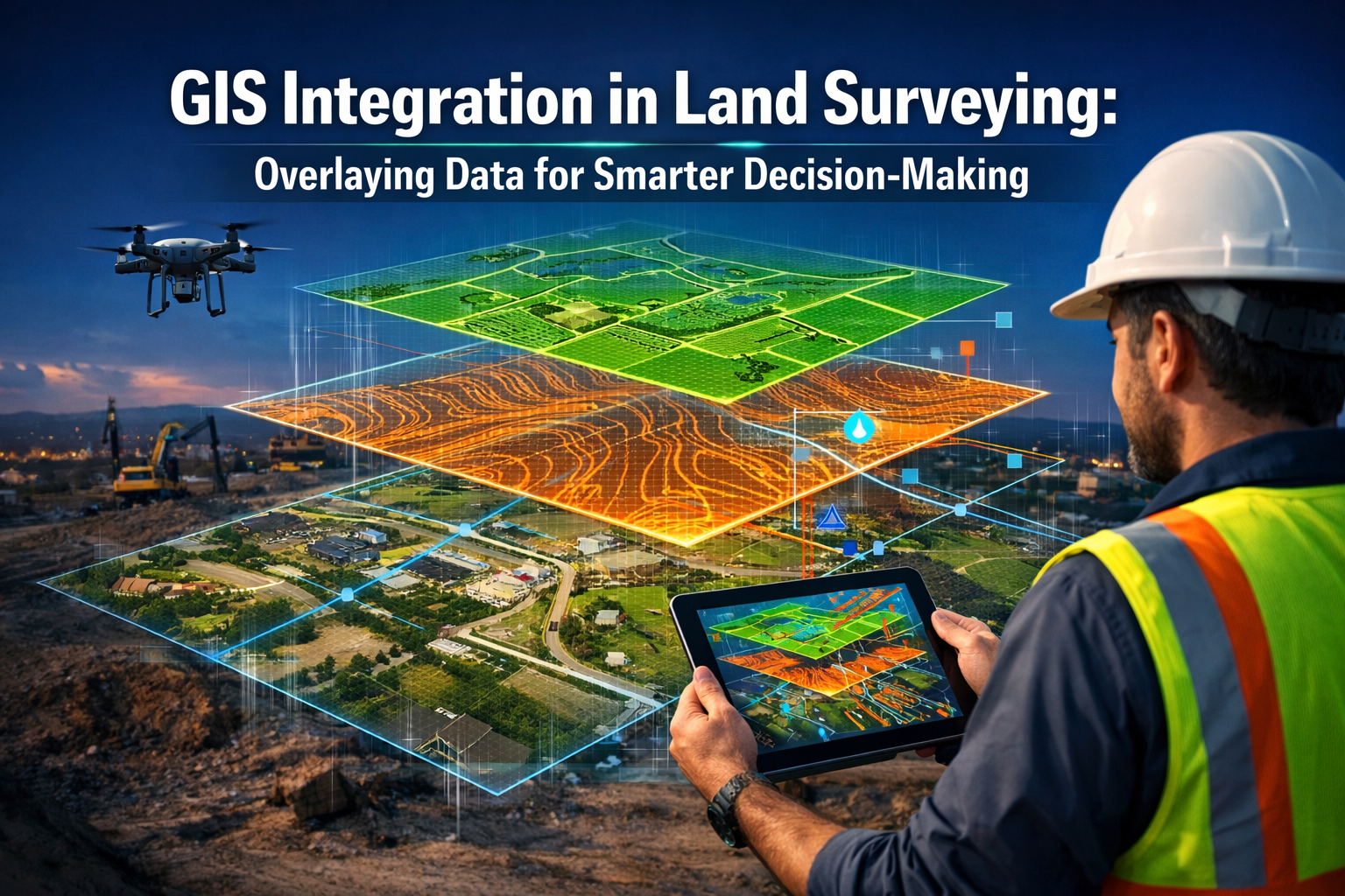
The modern land surveying profession stands at a technological crossroads. Traditional surveying methods—while accurate—often produce isolated datasets that exist in silos, making comprehensive spatial analysis challenging and time-consuming. Enter Geographic Information Systems (GIS), a transformative technology that enables surveyors to overlay multiple datasets within a single integrated platform, fundamentally changing how professionals approach land analysis and decision-making. GIS integration in land surveying: overlaying data for smarter decision-making has evolved from a specialized niche to an essential capability that defines competitive advantage in 2026.
Imagine being able to view property boundaries, zoning regulations, utility networks, topographic features, and environmental constraints simultaneously on a single interactive map. This capability—once the domain of large government agencies—is now accessible to surveying firms of all sizes, enabling pattern recognition, risk identification, and strategic planning that was previously impossible with conventional methods.
Key Takeaways
✅ Centralized Data Management: GIS platforms consolidate zoning information, property boundaries, utility locations, and topographic data into unified visual systems, eliminating data silos and improving accessibility.[1]
✅ Enhanced Pattern Recognition: Overlaying multiple datasets reveals spatial relationships, trends, and potential conflicts that remain invisible in traditional survey documents, supporting proactive decision-making.[1]
✅ Cloud-Based Collaboration: Modern GIS integration leverages cloud platforms for real-time file sharing, 3D visualization, and seamless communication between surveyors, engineers, and architects.[2]
✅ Digital Twin Deliverables: Surveying firms are transitioning from static plat documents to interactive digital-twin models that provide ongoing value throughout project lifecycles.[2]
✅ Precision and Accuracy Assurance: Survey professionals play critical roles in maintaining GIS dataset integrity, particularly as GNSS reliability faces emerging challenges from signal interference and environmental factors.[4]
Understanding GIS Integration in Modern Land Surveying
What Is GIS Integration?
Geographic Information Systems (GIS) represent sophisticated software platforms designed to capture, store, analyze, and visualize spatial data. When integrated into land surveying workflows, GIS transforms raw survey measurements into actionable intelligence by combining them with contextual information from multiple sources.
At its core, GIS integration enables surveyors to:
- Layer multiple datasets on a single coordinate system
- Analyze spatial relationships between different features
- Visualize complex information through interactive maps
- Generate predictive models based on historical patterns
- Share findings with stakeholders through accessible formats
The transition from traditional surveying to GIS-integrated workflows represents more than technological adoption—it fundamentally reimagines the surveyor's role from data collector to spatial analyst and strategic advisor.
The Evolution of Surveying Technology
Traditional land surveying relied on precise measurements recorded in field books, translated into CAD drawings, and delivered as static documents. While these methods provided accurate boundary determinations and topographic survey information, they offered limited analytical capabilities.
The integration of GIS technology has created a paradigm shift. By 2026, surveying deliverables have transitioned from static documents to interactive cloud-based systems enabling instant file sharing, 3D browser-based visualization, real-time revision syncing, and integrated communication with engineers and architects.[2] This evolution positions surveyors as central figures in collaborative project planning rather than isolated technical specialists.
Key Components of GIS-Integrated Surveying
A comprehensive GIS-integrated surveying system typically includes:
| Component | Function | Benefit |
|---|---|---|
| Data Acquisition Tools | GPS/GNSS receivers, total stations, drones, laser scanners | High-precision spatial data collection |
| GIS Software Platform | ArcGIS, QGIS, AutoCAD Civil 3D | Data processing, analysis, and visualization |
| Cloud Infrastructure | Azure, AWS, Autodesk Cloud | Real-time collaboration and accessibility |
| Mobile Applications | Field data collection apps | On-site verification and updates |
| Database Management | Spatial databases (PostGIS, SQL Server) | Centralized data storage and retrieval |
| Visualization Tools | 3D modeling, virtual reality interfaces | Stakeholder communication |
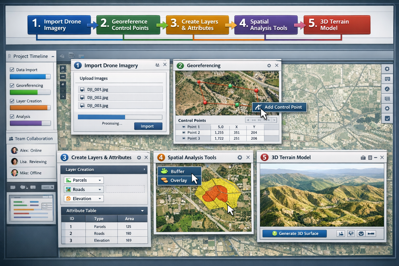
This integrated ecosystem enables surveyors to collect field data, process it within GIS platforms, analyze spatial relationships, and deliver interactive models—all within streamlined workflows that dramatically reduce project timelines.
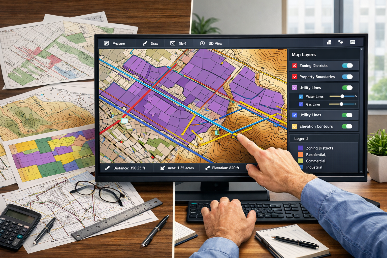
Centralizing Critical Data: Zoning, Boundaries, and Utilities
The Power of Multi-Dataset Overlay
One of the most transformative capabilities of GIS integration in land surveying: overlaying data for smarter decision-making is the ability to overlay multiple datasets within a single integrated map. GIS enables surveyors to combine zoning information, property boundaries, and utility locations, facilitating comprehensive spatial analysis that reveals relationships invisible in isolated datasets.[1]
Consider a typical urban development project. Traditional approaches would require consulting separate documents for:
- 📋 Property boundary surveys
- 🏛️ Municipal zoning regulations
- 🔌 Utility infrastructure maps
- 🌊 Floodplain designations
- 🌳 Environmental protection zones
- 🚗 Transportation corridors
With GIS integration, these datasets exist as transparent layers that can be toggled on and off, analyzed individually or collectively, and queried for specific attributes. This centralization eliminates the time-consuming process of cross-referencing multiple documents and reduces the risk of overlooking critical constraints.
Zoning Information Integration
Zoning regulations define how land can be used, establishing parameters for building heights, setbacks, density, and permitted activities. Integrating zoning data into GIS platforms provides surveyors and developers with immediate visual understanding of regulatory constraints.
Benefits of GIS-integrated zoning analysis include:
- Visual clarity of zoning district boundaries overlaid on property parcels
- Attribute queries to identify permitted uses, density requirements, and variance histories
- Buffer analysis to determine setback compliance and adjacency restrictions
- Change tracking to monitor zoning amendments and their spatial impacts
This integration proves particularly valuable when working with chartered surveyors who must ensure compliance with complex regulatory frameworks while advising clients on development feasibility.
Property Boundary Precision
Accurate property boundaries form the foundation of land surveying. GIS integration enhances traditional boundary surveying by providing historical context, adjacent parcel information, and automated conflict detection.
Modern GIS platforms enable surveyors to:
- Compare current surveys with historical boundary records
- Identify discrepancies between recorded deeds and physical evidence
- Analyze encroachments by overlaying improvements with legal boundaries
- Document easements and rights-of-way with precise spatial references
For professionals dealing with land boundary disagreements, GIS provides compelling visual evidence that facilitates resolution by clearly illustrating spatial relationships and historical precedents.
Utility Location Management
Underground and overhead utilities represent critical infrastructure that must be identified before any excavation or construction activity. Utility strikes cause project delays, safety hazards, and expensive repairs—making accurate utility mapping essential.
GIS integration revolutionizes utility management by:
- 🔍 Consolidating records from multiple utility providers into unified maps
- 📍 Georeferencing utility locations with survey-grade precision
- ⚠️ Highlighting conflicts between proposed construction and existing infrastructure
- 📊 Tracking attributes such as pipe diameter, material, installation date, and depth
The combination of drone imagery and satellite data enables real-time land surveying, boundary verification, and environmental assessments with high-resolution geospatial data, reducing manual fieldwork requirements for utility verification.[3]
Environmental and Regulatory Layers
Beyond the fundamental trio of zoning, boundaries, and utilities, comprehensive GIS integration incorporates environmental and regulatory datasets that influence development decisions:
- Wetlands and watercourses protected under environmental regulations
- Floodplain designations affecting insurance and construction requirements
- Soil classifications informing foundation design and septic system feasibility
- Archaeological and cultural resource protection zones
- Wildlife habitat corridors requiring preservation
- Transportation improvement plans affecting future access
By overlaying these datasets, surveyors can identify potential conflicts early in the planning process, enabling proactive design modifications that avoid costly delays during permitting and construction phases.
Pattern Analysis and Visualization: Tools and Techniques
Identifying Spatial Patterns Through Data Overlay
The primary advantages of GIS integration include centralized data management for geospatial datasets, enhanced pattern and trend identification in land use analysis, and improved decision-making through accessible visual representations.[1] When multiple datasets are overlaid, previously hidden patterns emerge, revealing opportunities and constraints that inform strategic planning.
Common pattern analysis applications include:
- Development density trends showing urban growth corridors
- Infrastructure capacity constraints identifying areas requiring utility upgrades
- Environmental risk zones where multiple hazards overlap
- Market opportunity areas where zoning supports underutilized land uses
- Transportation accessibility patterns affecting property values
These analytical capabilities transform surveyors from measurement technicians into strategic advisors who provide insights that directly influence project feasibility and design decisions.
Essential GIS Tools for Land Surveying in 2026
The GIS software landscape offers numerous platforms, each with distinct strengths for surveying applications. Understanding the capabilities and appropriate applications of leading tools ensures optimal technology selection.
ArcGIS Platform
Esri's ArcGIS remains the industry standard for comprehensive GIS capabilities. Cloud-based integrations between ArcGIS and Autodesk technology allow simultaneous visualization of construction data alongside GIS data, including terrain models, representing a significant interoperability development.[7]
Key features for surveyors:
- Advanced spatial analysis tools
- Extensive data format support
- Mobile field data collection (ArcGIS Field Maps)
- 3D visualization and modeling
- Enterprise-level data management
- Industry-specific extensions
QGIS (Open Source Alternative)
For firms seeking cost-effective solutions without licensing fees, QGIS provides robust functionality suitable for most surveying applications.
Advantages include:
- No licensing costs
- Active development community
- Plugin ecosystem for specialized functions
- Cross-platform compatibility
- Integration with PostGIS databases
AutoCAD Civil 3D with GIS Integration
Many surveying firms leverage AutoCAD Civil 3D's familiar interface enhanced with GIS capabilities through data connections and coordinate system management.
Benefits for surveyors:
- Seamless CAD-GIS workflow
- Terrain modeling and analysis
- Alignment and grading design
- Integration with survey equipment
- BIM collaboration capabilities
Cloud-Based Platforms
Cloud infrastructure has become essential for collaborative projects. Platforms like Autodesk Construction Cloud and Esri ArcGIS Online enable real-time data sharing and visualization without requiring specialized software installation.
These platforms support the transition to digital-twin deliverables—comprehensive interactive models incorporating terrain, infrastructure, and analytical layers—that provide ongoing value to clients beyond traditional plat documents.[2]
Visualization Techniques for Effective Communication
Even the most sophisticated analysis fails if stakeholders cannot understand the findings. Effective visualization transforms complex spatial data into accessible insights that inform decision-making.
Heat Maps and Density Analysis
Heat maps use color gradients to represent data intensity across geographic areas, making patterns immediately apparent. Applications include:
- Population density affecting infrastructure demand
- Property value distributions guiding development targeting
- Environmental risk intensity zones
- Traffic volume patterns influencing access design
3D Terrain Modeling
Three-dimensional representations provide intuitive understanding of topographic relationships, particularly valuable for:
- Grading and drainage design
- Viewshed analysis for aesthetic considerations
- Cut-and-fill volume calculations
- Slope stability assessment
Integrated GIS platforms now support complex environmental and infrastructure modeling, including slope erosion projections, water flow simulations, vegetation pattern change monitoring, and infrastructure stress testing within single interactive models.[2]
Time-Series Animation
Visualizing change over time reveals trends and projections that static maps cannot convey. Time-series animations effectively illustrate:
- Historical development patterns
- Projected growth scenarios
- Seasonal environmental changes
- Infrastructure deterioration progression
Interactive Web Maps
Web-based mapping applications democratize access to spatial data, enabling stakeholders without GIS expertise to explore project information. These tools support:
- Public engagement in planning processes
- Client self-service data exploration
- Transparent communication with regulatory agencies
- Ongoing asset management post-construction
Advanced Analytical Capabilities
Beyond visualization, GIS platforms provide sophisticated analytical tools that generate actionable intelligence from spatial data.
Buffer and Proximity Analysis
Buffer analysis creates zones at specified distances from features, enabling automated compliance checking for setback requirements, impact assessment for proposed developments, and service area determination for utilities.
Overlay Analysis
Overlay operations combine multiple datasets to identify areas meeting specific criteria. Common applications include:
- Suitability analysis identifying optimal development locations
- Conflict detection revealing incompatible land uses
- Risk assessment mapping areas where multiple hazards overlap
Network Analysis
For projects involving transportation or utility infrastructure, network analysis tools optimize routing, identify service gaps, and model flow patterns through connected systems.
Spatial Statistics
Advanced statistical tools identify clustering, dispersion patterns, and spatial autocorrelation, supporting evidence-based planning decisions with quantitative rigor.
Benefits for Planning Projects in 2026
Enhanced Decision-Making Through Data Integration
The fundamental value proposition of GIS integration in land surveying: overlaying data for smarter decision-making lies in its ability to improve decision quality by providing comprehensive spatial context. When planners and developers can visualize all relevant constraints and opportunities simultaneously, they make more informed choices that reduce risk and optimize outcomes.
Quantifiable benefits include:
- ⏱️ Reduced planning time through automated analysis replacing manual cross-referencing
- 💰 Cost savings from early conflict identification preventing expensive design revisions
- 📉 Risk mitigation through comprehensive constraint mapping
- 🎯 Improved accuracy in feasibility assessments and cost estimations
- 🤝 Enhanced collaboration among multidisciplinary project teams
Integration of land, asset, and operational data on GIS maps has demonstrated outcomes including enhanced operational efficiency and reduced land-related risks for property managers.[9]
Streamlined Regulatory Compliance
Navigating complex regulatory requirements represents a significant challenge in development projects. GIS integration simplifies compliance by:
- Automating setback verification against zoning requirements
- Documenting environmental constraints with georeferenced evidence
- Generating compliance reports with spatial exhibits for permitting applications
- Tracking regulatory changes affecting project sites
- Maintaining audit trails of decision-making processes
For professionals conducting structural surveys and building surveys, GIS integration provides context that enhances assessment accuracy by revealing site-specific constraints and historical development patterns.
Improved Stakeholder Communication
Technical professionals often struggle to communicate complex spatial information to non-technical stakeholders. GIS visualization bridges this gap by:
- Translating data into intuitive visual formats that require no specialized knowledge
- Enabling interactive exploration where stakeholders can query information relevant to their concerns
- Supporting public engagement in planning processes through accessible web maps
- Facilitating consensus building by providing objective spatial evidence
This communication enhancement proves particularly valuable when working with chartered surveyors who must explain technical findings to property owners, attorneys, and regulatory officials.
Infrastructure Asset Management
A significant market opportunity has emerged for surveyors to provide 3D GIS-powered asset lifecycle management systems, enabling municipalities and private asset owners to manage aging infrastructure with spatial data capture and advanced modeling—extending surveyor value beyond traditional project boundaries.[5]
Asset management applications include:
- Inventory documentation of existing infrastructure with precise locations and attributes
- Condition assessment tracking over time to prioritize maintenance
- Replacement planning based on age, condition, and strategic importance
- Work order management with spatial routing optimization
- Performance monitoring against service level agreements
These capabilities position surveying firms as long-term partners in infrastructure stewardship rather than one-time service providers.
Building Information Modeling (BIM) Integration
Land surveyors are increasingly integrating geospatial data into BIM models, collaborating directly with architects and construction professionals to enhance project planning, reduce design conflicts, and improve overall construction efficiency.[2]
BIM-GIS integration enables:
- Site context modeling placing building designs within accurate terrain and infrastructure contexts
- Clash detection identifying conflicts between proposed construction and existing conditions
- 4D construction sequencing incorporating temporal dimensions into spatial planning
- Facility management leveraging as-built models for ongoing operations
This integration transforms surveying from a preliminary project phase into an ongoing collaborative process that adds value throughout design, construction, and operations.
Real-Time Data and Adaptive Planning
The combination of drone imagery and satellite data enables real-time land surveying, boundary verification, and environmental assessments with high-resolution geospatial data, reducing manual fieldwork requirements.[3]
Real-time capabilities support:
- Construction monitoring comparing as-built conditions against design intent
- Environmental compliance tracking sediment control and vegetation preservation
- Progress documentation for payment applications and schedule verification
- Change order justification with before-and-after spatial evidence
These capabilities prove particularly valuable for data analysis applications where temporal patterns reveal insights unavailable in static snapshots.
Risk Identification and Mitigation
Comprehensive spatial analysis reveals risks that might otherwise remain hidden until they cause project delays or cost overruns:
- Title defects identified through boundary overlay analysis
- Environmental liabilities discovered through historical land use research
- Utility conflicts detected before excavation begins
- Access constraints recognized during preliminary site analysis
- Regulatory barriers identified early in feasibility assessment
Early risk identification enables proactive mitigation strategies that prevent problems rather than reacting to them after they occur.
Predictive Modeling and Scenario Analysis
Advanced GIS capabilities support predictive modeling that informs long-term planning:
- Growth projections based on historical development patterns
- Infrastructure capacity planning anticipating future demand
- Climate change adaptation modeling sea level rise and increased precipitation
- Market analysis identifying emerging development opportunities
Scenario analysis tools enable comparison of alternative development approaches, supporting evidence-based selection of optimal strategies.
Practical Implementation: Getting Started with GIS Integration
Assessing Organizational Readiness
Successful GIS integration requires more than software acquisition—it demands organizational commitment, staff development, and process redesign. Before beginning implementation, surveying firms should assess:
Technical Infrastructure:
- Hardware capabilities for GIS processing
- Network bandwidth for cloud-based platforms
- Data storage and backup systems
- Field equipment compatibility
Human Resources:
- Staff technical proficiency and learning capacity
- Training time availability
- Willingness to adopt new workflows
- Access to GIS expertise (internal or contracted)
Business Processes:
- Current data management practices
- Project delivery workflows
- Client communication methods
- Quality control procedures
Selecting Appropriate GIS Platforms
Platform selection should align with organizational needs, budget constraints, and technical capabilities:
For small firms with limited budgets:
- QGIS provides robust functionality without licensing costs
- Cloud-based viewers enable client delivery without software requirements
- Mobile apps support field data collection on consumer devices
For established firms seeking comprehensive capabilities:
- ArcGIS offers industry-leading tools with extensive support
- AutoCAD Civil 3D integration leverages existing CAD expertise
- Enterprise licenses support multi-user collaboration
For specialized applications:
- Drone mapping platforms (Pix4D, DroneDeploy) for aerial data processing
- Asset management systems (Cityworks, CartegGraph) for infrastructure inventory
- Web GIS platforms (ArcGIS Online, Mapbox) for stakeholder engagement
Data Acquisition and Management
Effective GIS implementation requires establishing robust data management practices:
Data Sources:
- Field survey measurements (GPS, total station, laser scanning)
- Public datasets (zoning, parcels, utilities, imagery)
- Client-provided information (plans, deeds, environmental reports)
- Third-party data services (aerial imagery, LiDAR, demographic data)
Data Standards:
- Coordinate system consistency across all datasets
- Attribute schema standardization for queryability
- Metadata documentation for data provenance
- Quality control procedures ensuring accuracy
Database Architecture:
- Centralized storage with backup redundancy
- Version control for tracking changes
- Access permissions protecting sensitive information
- Archive procedures for completed projects
Survey professionals are playing increasingly critical roles in ensuring GIS datasets maintain precision and accuracy, particularly given emerging risks of GNSS jamming, spoofing, and signal fluctuations caused by solar cycles.[4]
Workflow Integration
GIS capabilities should enhance rather than disrupt existing workflows:
Field Data Collection:
- Mobile GIS apps for real-time data entry
- GPS/GNSS integration for automated positioning
- Photo documentation with geolocation
- Offline capabilities for remote locations
Office Processing:
- Automated data import from field equipment
- Quality control checks using spatial analysis
- Integration with CAD for plan production
- Analysis and modeling for deliverable preparation
Client Delivery:
- Interactive web maps for data exploration
- PDF maps with embedded geospatial information
- 3D visualizations for presentation
- Data packages for client GIS systems
Training and Skill Development
Technology implementation succeeds or fails based on user adoption. Comprehensive training programs should include:
Initial Training:
- Software fundamentals and interface navigation
- Data import and coordinate system management
- Basic analysis and visualization techniques
- Quality control procedures
Advanced Training:
- Specialized analysis tools for specific applications
- Scripting and automation for efficiency
- 3D modeling and visualization
- Web map development and deployment
Ongoing Development:
- Regular technology updates and new feature training
- Best practice sharing among team members
- Industry conference attendance
- Online learning resources and certifications
Measuring Return on Investment
Justifying GIS investment requires demonstrating tangible value:
Efficiency Metrics:
- Time savings in data processing and analysis
- Reduced field visits through remote verification
- Faster project delivery timelines
- Decreased revision cycles
Quality Improvements:
- Error reduction in deliverables
- Enhanced client satisfaction scores
- Reduced liability exposure
- Improved regulatory compliance
Revenue Enhancement:
- New service offerings (asset management, planning consulting)
- Higher project values from enhanced deliverables
- Expanded client base seeking advanced capabilities
- Competitive differentiation in proposals
Industry Trends and Future Directions
Government GIS Initiatives
The Department of Transportation has established a formal GIS Strategic Plan for 2026-2030 that sets national priorities for geospatial governance, data integration, technology utilization, and workforce development across federal agencies.[8] This initiative signals increasing government reliance on GIS for infrastructure planning and management, creating opportunities for private sector surveyors with compatible capabilities.
Key priorities include:
- Data standardization enabling interoperability across agencies
- Cloud infrastructure supporting scalable data sharing
- Workforce development building GIS competency
- Public engagement through accessible mapping platforms
Surveying firms aligned with these priorities position themselves as preferred partners for government contracts and public-private collaborations.
Artificial Intelligence and Machine Learning
AI is changing the role of the surveyor in architecture, engineering, and construction by automating routine tasks and enabling predictive analytics.[4] GIS integration with AI capabilities includes:
- Automated feature extraction from imagery and point clouds
- Pattern recognition identifying anomalies and trends
- Predictive modeling forecasting infrastructure deterioration
- Natural language processing enabling conversational data queries
These capabilities free surveyors from routine data processing, enabling focus on higher-value analytical and advisory services.
Digital Twin Technology
Commercial surveying firms are transitioning to provide digital-twin deliverables—comprehensive interactive models incorporating terrain, infrastructure, and analytical layers—to support client decision-making beyond traditional plat documents.[2]
Digital twins represent virtual replicas of physical assets that:
- Integrate multiple data sources into unified models
- Update in real-time reflecting current conditions
- Support scenario testing before physical implementation
- Enable predictive maintenance through performance monitoring
This technology extends surveyor engagement throughout asset lifecycles rather than limiting involvement to initial project phases.
Emerging Challenges and Considerations
While GIS integration offers substantial benefits, implementation presents challenges requiring attention:
Data Quality and Accuracy:
Survey professionals must ensure GIS datasets maintain precision standards, particularly as GNSS reliability faces emerging risks from signal interference.[4] Establishing quality control procedures and maintaining survey-grade accuracy in GIS databases requires vigilance and expertise.
Data Security and Privacy:
Centralized spatial databases containing sensitive property information require robust security measures protecting against unauthorized access and cyber threats. Compliance with data protection regulations adds complexity to data management practices.
Technology Obsolescence:
Rapid technological evolution creates risks of platform obsolescence and data format incompatibility. Long-term data preservation strategies and migration planning ensure continued accessibility of historical information.
Skill Gap:
The transition from traditional surveying to GIS-integrated workflows requires new competencies that may exceed current staff capabilities. Recruitment challenges and training investments represent significant organizational commitments.
Industry Recognition and Adoption
More industries are actively recognizing and adopting GIS, positioning it as one of the most vital innovations in surveying.[1] This widespread adoption creates network effects where GIS capabilities become expected rather than exceptional, making integration essential for competitive positioning.
The surveying profession increasingly recognizes that GIS integration represents not merely a technological enhancement but a fundamental redefinition of professional value—from measurement services to spatial intelligence and strategic advisory capabilities.
Conclusion: Embracing GIS for Competitive Advantage

GIS integration in land surveying: overlaying data for smarter decision-making has evolved from specialized capability to essential competency in 2026. The ability to centralize zoning information, property boundaries, utility locations, and environmental constraints within unified platforms enables pattern analysis and visualization that fundamentally improves planning outcomes.
The benefits extend beyond operational efficiency to encompass strategic advantages including enhanced decision quality, improved stakeholder communication, expanded service offerings, and long-term client relationships through asset management capabilities. As government agencies, private developers, and infrastructure owners increasingly expect GIS-integrated deliverables, surveying firms without these capabilities face competitive disadvantages that threaten market relevance.
Actionable Next Steps
For surveying professionals ready to embrace GIS integration:
- Assess current capabilities against industry standards and client expectations
- Develop implementation roadmap with phased technology adoption, training programs, and workflow integration
- Start small with pilot projects demonstrating value before enterprise-wide deployment
- Invest in training ensuring staff develop competencies matching technological capabilities
- Establish data management practices maintaining accuracy and accessibility
- Communicate value to clients through case studies and demonstration projects
- Monitor industry trends staying current with emerging technologies and methodologies
The transition to GIS-integrated surveying represents an investment in professional relevance and competitive positioning. Firms that embrace this evolution position themselves as strategic partners providing spatial intelligence rather than commodity measurement services.
For those seeking professional surveying services with advanced GIS capabilities, working with experienced professional surveyor services ensures access to the analytical tools and expertise that modern projects demand. Whether conducting topographic surveys, resolving property boundaries disputes, or supporting complex development planning, GIS integration delivers the comprehensive spatial understanding that drives smarter decisions and successful outcomes.
The future of land surveying lies not in more precise measurements alone, but in the intelligent integration and analysis of spatial data that transforms information into insight. Those who master GIS integration will lead the profession forward, while those who resist risk obsolescence in an increasingly data-driven built environment.
References
[1] The Future Of Land Surveying Technology And Upcoming Trends In 2026 – https://metricop.com/blogs/land-surveying/the-future-of-land-surveying-technology-and-upcoming-trends-in-2026
[2] Future Land Surveying 2026 – https://haller-blanchard.com/future-land-surveying-2026/
[3] Develop Land Management Software – https://www.aleaitsolutions.com/develop-land-management-software/
[4] How Ai Is Changing The Role Of The Surveyor In Aec – https://www.gim-international.com/content/article/how-ai-is-changing-the-role-of-the-surveyor-in-aec
[5] Doubling Down On Digital – https://amerisurv.com/2026/02/01/doubling-down-on-digital/
[7] With Gis Technology Drone Industry Alights In Reality – https://www.esri.com/about/newsroom/arcnews/with-gis-technology-drone-industry-alights-in-reality
[8] Us Dot Gis Strategic Plan 2026 30 – https://www.transportation.gov/sites/dot.gov/files/2025-12/US-DOT-GIS-Strategic-Plan-2026-30.pdf
[9] Land Acquisition And Management In 2026 – https://lamsapp.com/blog/land-acquisition-and-management-in-2026