{"cover":"Professional landscape format (1536×1024) hero image featuring bold text overlay 'GIS Integration for Modern Property Surveyors: Enhancing Data Management and Decision-Making' in extra large 72pt white sans-serif font with dark gradient shadow, centered in upper third. Background shows modern surveyor using tablet displaying interactive GIS map with colorful property boundary overlays, zoning layers, and utility infrastructure lines on digital terrain model. Split-screen composition showing physical property site on left and corresponding GIS data visualization on right. Color scheme: deep navy blue, bright cyan, orange accent highlights. High contrast, professional magazine cover quality, editorial technology aesthetic with subtle grid pattern overlay suggesting precision mapping coordinates.","content":["Detailed landscape format (1536×1024) image showing professional surveyor in high-visibility vest examining property boundaries using tablet displaying multi-layered GIS interface. Screen prominently shows transparent overlay system with distinct color-coded layers: green zoning boundaries, red utility lines (water, gas, electric), blue property parcel boundaries, and yellow topographic contours on satellite imagery base map. Split-screen composition with physical terrain photograph on left and corresponding GIS data layers on right. Include legend showing layer types, scale bar, north arrow, and coordinate grid. Modern clean interface design with professional surveying equipment (total station, GPS receiver) visible in background. Bright daylight setting, sharp focus on tablet screen, photorealistic rendering emphasizing data centralization concept.","Detailed landscape format (1536×1024) infographic illustration demonstrating GIS workflow transformation for property surveyors. Left side shows traditional paper-based surveying methods with physical maps, manual measurements, filing cabinets, and disconnected data sources in muted grayscale tones. Center features bold transformation arrow with GIS integration icons. Right side displays modern digital workflow in vibrant colors: cloud-based data storage, real-time field data collection on mobile devices, automated analysis dashboards, interactive 3D property models, and collaborative multi-user access. Include specific visual elements: database icons, wireless connectivity symbols, AI analysis graphics, and efficiency metrics showing time savings percentages. Professional business technology aesthetic with clean lines and modern typography labeling each workflow stage.","Detailed landscape format (1536×1024) technical diagram showing comprehensive GIS decision-making dashboard for property development project. Central interactive map display shows proposed development site with multiple analytical overlays: flood zone risk areas in blue gradient, soil composition heat map, environmental constraint boundaries, access route optimization paths in green, and neighboring property impact zones in yellow transparency. Surrounding the main map are data panels showing: comparative site analysis charts, cost-benefit matrices, regulatory compliance checklists, stakeholder communication timeline, and automated report generation previews. Include realistic UI elements: dropdown menus for layer selection, slider controls for transparency adjustment, measurement tools, and export options. Professional dark-themed interface with bright data visualizations, resembling enterprise GIS software dashboard used by chartered surveyors for strategic planning and client presentations."]

Picture a property surveyor standing at a complex development site, instantly accessing decades of zoning history, underground utility networks, and environmental constraints—all layered on a single interactive map displayed on a tablet. This is not a futuristic vision; it is the reality of GIS integration for modern property surveyors in 2026. Geographic Information Systems (GIS) have transformed how surveyors collect, manage, analyze, and present spatial data, fundamentally changing the profession's approach to data management and decision-making.
GIS Integration for Modern Property Surveyors: Enhancing Data Management and Decision-Making represents a critical evolution in surveying practice. By overlaying zoning regulations, property boundaries, utility infrastructure, and environmental data on interactive digital maps, surveyors can centralize previously scattered geospatial information. This integration enables sophisticated land use analysis, streamlines project planning, and provides clients with comprehensive insights that were impossible to achieve with traditional methods alone.
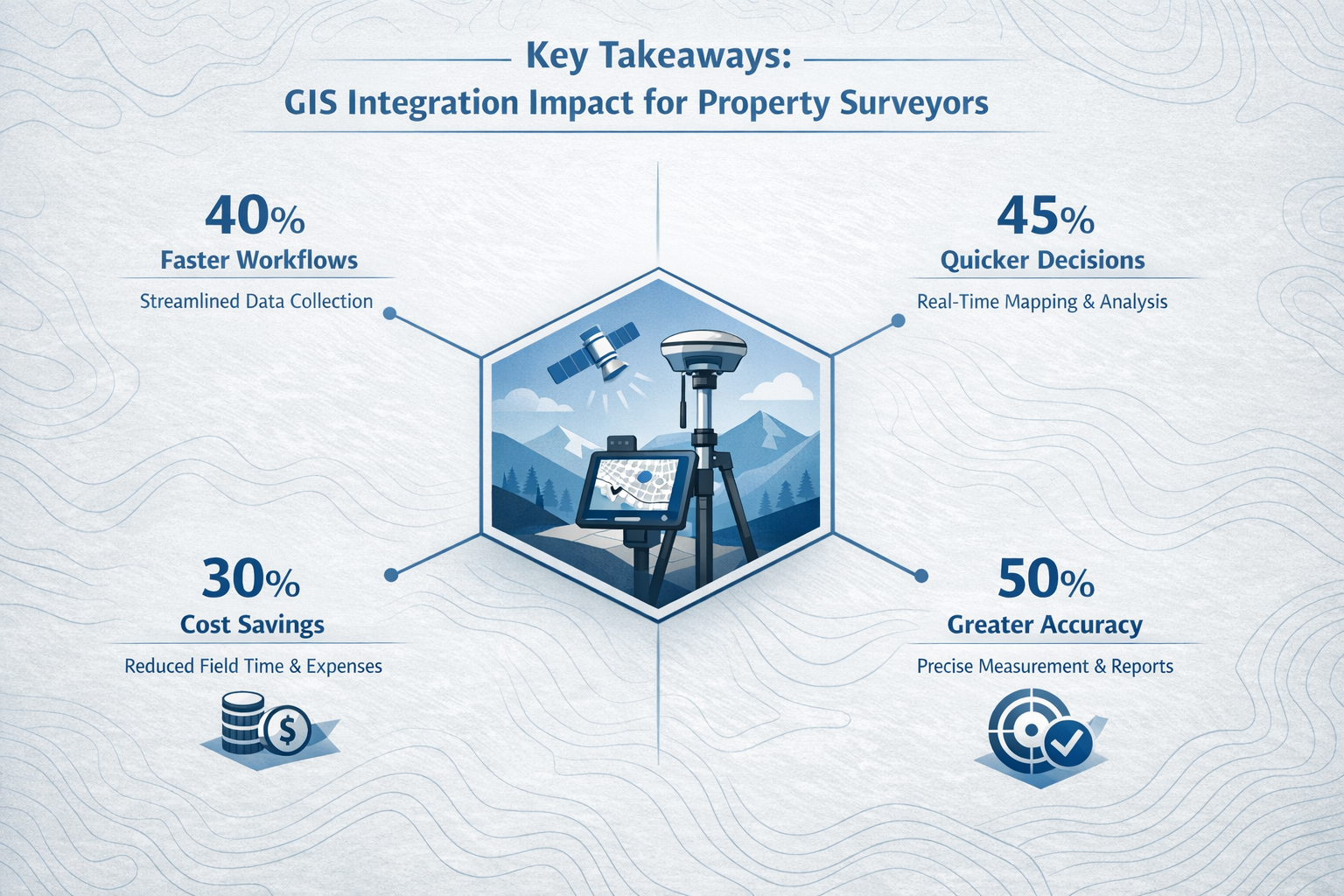
Key Takeaways
- Centralized Data Management: GIS platforms consolidate property boundaries, zoning regulations, utility locations, and topographic information into single, accessible systems that eliminate data silos and reduce errors.
- Enhanced Decision-Making Capabilities: Interactive map overlays enable surveyors to perform complex spatial analysis, identify constraints, and evaluate development scenarios in real-time, improving client advisory services.
- Mobile Field Integration: Modern GIS solutions support field data collection through GPS-enabled devices, allowing surveyors to capture survey-grade measurements and immediately integrate them with existing datasets.
- AI-Powered Analytics: The latest GIS platforms incorporate artificial intelligence capabilities that automate pattern recognition, predict infrastructure conflicts, and generate insights from massive geospatial datasets.[4]
- Improved Collaboration and Communication: GIS-based visualizations provide intuitive, shareable formats that help clients, stakeholders, and regulatory authorities understand complex property conditions and make informed decisions.[1]
Understanding GIS Integration for Modern Property Surveyors
What Is GIS Integration in Property Surveying?
Geographic Information Systems (GIS) integration involves combining traditional surveying measurements with digital mapping technologies that organize, analyze, and visualize spatial data. For property surveyors, this means transforming field measurements, boundary descriptions, and site observations into layered digital maps that can display multiple types of information simultaneously.
At its core, GIS integration allows surveyors to:
- Overlay multiple data layers including property boundaries, zoning districts, utility corridors, flood zones, soil types, and topographic features
- Link spatial features to attribute data such as ownership records, assessment values, permit histories, and compliance documentation
- Perform spatial analysis to identify relationships, calculate areas, measure distances, and evaluate site suitability
- Share interactive maps with clients, planners, and stakeholders through web-based platforms and mobile applications
The technology has evolved significantly from simple digital mapping to sophisticated analytical platforms. According to the U.S. Department of Transportation's GIS Strategic Plan 2026-2030, federal agencies are prioritizing geospatial data that is "findable, accessible, interoperable, and reusable"—standards that directly benefit property surveyors working across jurisdictions.[4]
The Evolution from Traditional to GIS-Enhanced Surveying
Traditional property surveying relied heavily on paper maps, manual calculations, and physical file storage. Surveyors would measure property corners with total stations or GPS receivers, record data in field books, and produce static plans showing boundaries and features. While accurate, this approach created several challenges:
📋 Challenges of Traditional Methods:
- Data stored in disconnected formats (paper plans, spreadsheets, CAD files)
- Difficulty accessing historical survey information
- Limited ability to analyze relationships between properties
- Time-consuming manual processes for updating information
- Challenges communicating complex spatial relationships to clients
GIS integration addresses these limitations by creating dynamic, interconnected data environments. Modern surveyors can now access decades of historical survey data, overlay current conditions, and project future scenarios—all within unified digital platforms. Professional organizations like the chartered surveyors community have recognized this transformation as essential to maintaining competitive advantage.
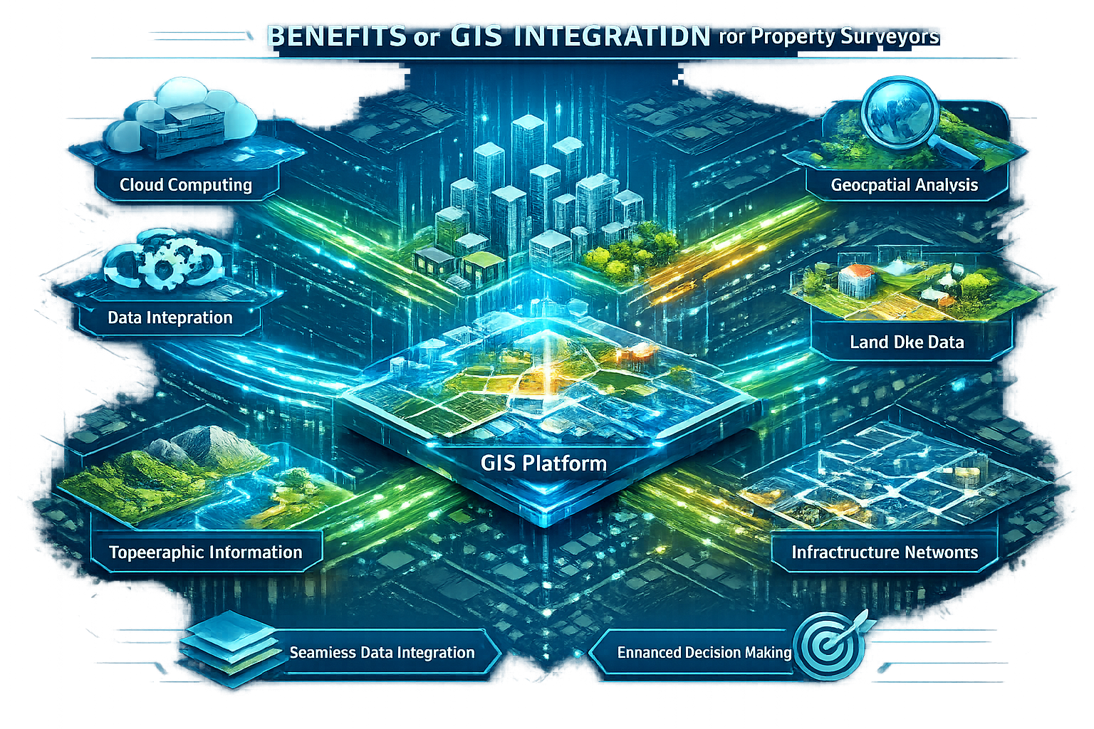
Key Components of GIS Systems for Surveyors
Effective GIS integration requires several technological components working together:
1. Data Capture Tools
- GPS/GNSS receivers for coordinate collection
- Total stations with data logging capabilities
- Mobile GIS applications for field data entry
- Drone-based photogrammetry and LiDAR scanning
- Ground Penetrating Radar (GPR) for subsurface utility detection[2]
2. GIS Software Platforms
- Desktop GIS applications (ArcGIS, QGIS, Carlson GIS)
- Mobile field collection apps
- Cloud-based data management systems
- Web mapping services for client access
Carlson GIS 2026, available at $1,350, specifically targets land surveyors with survey-grade capabilities for data capture, topology analysis, and multi-format file import/export.[5] This represents the specialized tools designed specifically for surveying professionals rather than general GIS users.
3. Data Layers and Formats
- Property boundary parcels
- Zoning and land use classifications
- Utility infrastructure (water, sewer, electric, gas, telecommunications)
- Topographic contours and elevation models
- Environmental constraints (wetlands, flood zones, protected areas)
- Transportation networks
- Building footprints and structures
4. Analysis and Visualization Tools
- Spatial query functions
- Buffer and overlay analysis
- 3D terrain modeling
- Automated report generation
- Interactive web maps
Benefits of GIS Integration for Modern Property Surveyors: Enhancing Data Management
Centralized Geospatial Data Management
One of the most significant advantages of GIS integration is the consolidation of disparate data sources into unified systems. Property surveyors traditionally juggled information from multiple agencies, historical archives, and field observations—often in incompatible formats. GIS platforms eliminate these data silos.
Data Centralization Benefits:
| Traditional Approach | GIS-Integrated Approach |
|---|---|
| Paper maps stored in filing cabinets | Digital layers accessible from any device |
| Separate databases for boundaries, utilities, zoning | Unified spatial database with linked attributes |
| Manual cross-referencing between sources | Automated spatial queries across datasets |
| Limited historical access | Complete temporal data showing changes over time |
| Single-user access to physical documents | Multi-user collaborative access with version control |
The U.S. Department of Transportation demonstrated this principle by successfully integrating disparate datasets from DOT and USDA using GIS tools, linear referencing, and dynamic segmentation to analyze critical agricultural transportation corridors.[4] Property surveyors can apply similar methodologies to combine municipal records, utility company data, environmental databases, and proprietary survey measurements.
For surveyors working in complex urban environments like Wandsworth or Knightsbridge, centralized data management is particularly valuable. These areas feature dense development, extensive underground infrastructure, and frequent property transactions that generate continuous data updates.
Improved Data Accuracy and Quality Control
GIS integration enhances data accuracy through several mechanisms:
✅ Automated Validation: GIS software can automatically detect geometric errors, such as gaps between adjacent parcels, overlapping boundaries, or impossible polygon configurations. These quality control checks identify problems that might go unnoticed in manual workflows.
✅ Coordinate System Standardization: GIS platforms enforce consistent coordinate systems and datum references, eliminating errors caused by mixing incompatible spatial reference systems.
✅ Attribute Consistency: Database structures within GIS ensure that property attributes (ownership, classification, dimensions) follow standardized formats and value ranges.
✅ Version Control and Audit Trails: Modern GIS platforms track who modified data, when changes occurred, and what was altered—creating accountability and enabling recovery from errors.
The Virginia Association of Surveyors' 2026 Convention Program includes formal courses introducing survey professionals to these practical advantages of integrating GIS into traditional surveying workflows, demonstrating industry recognition of the quality improvements.[3]
Enhanced Field Data Collection Efficiency
Mobile GIS technology has revolutionized how surveyors collect data in the field. The DOT 2026-2030 strategic priorities specifically identify "opportunities to assess current uses, needs, and challenges to leveraging mobile GIS technology in the field and improve access to mobile GIS tools and workflows."[4]
Mobile GIS Capabilities for Field Surveyors:
📱 Real-Time Data Integration: Surveyors can view existing GIS layers while collecting new measurements, immediately identifying discrepancies or conflicts.
📱 Offline Functionality: Modern mobile GIS apps allow field work in areas without cellular coverage, synchronizing data when connectivity returns.
📱 Photo and Video Geotagging: Site photographs automatically link to precise locations, creating visual documentation tied to specific features.
📱 Voice Notes and Annotations: Surveyors can record observations that attach to map features, preserving contextual information.
📱 Automated Form Completion: Pre-configured data entry forms reduce errors and ensure consistent attribute collection.
High-resolution data collection has become faster, more accurate, and more accessible compared to traditional surveying methods, thanks to advances in satellite imagery, drone surveys, and mobile GIS applications.[1] Surveyors conducting boundary surveys can now capture comprehensive site conditions in a fraction of the time previously required.
Streamlined Data Sharing and Collaboration
GIS integration transforms how surveyors share information with clients, colleagues, and regulatory authorities. Traditional survey plans required physical delivery or email attachments of static documents. GIS-enabled workflows support:
🔗 Web-Based Map Viewers: Clients access interactive maps through standard web browsers without specialized software, zooming to areas of interest and toggling layers on and off.
🔗 Cloud Collaboration Platforms: Multiple team members can simultaneously work on survey projects, with changes synchronized across all users.
🔗 Automated Report Generation: GIS systems can extract data and generate standardized reports, reducing manual documentation time.
🔗 API Integration: GIS platforms connect with other business systems (CRM, project management, accounting) through application programming interfaces.
🔗 Public Portals: Municipalities and agencies increasingly provide public GIS portals where surveyors can access official records, reducing trips to government offices.
This collaborative capability proves especially valuable for complex projects requiring input from multiple specialists. A building surveyor conducting a comprehensive property assessment can share the GIS project with structural engineers, environmental consultants, and planning advisors, ensuring everyone works from identical spatial information.
GIS Integration for Modern Property Surveyors: Enhancing Decision-Making Capabilities
Advanced Spatial Analysis for Land Use Planning
GIS integration elevates property surveying from measurement and documentation to strategic analysis and advisory services. The ability to overlay zoning regulations, environmental constraints, and infrastructure capacity on property boundaries enables surveyors to provide sophisticated land use insights.
Spatial Analysis Applications:
🎯 Site Suitability Assessment: Evaluating potential development sites by combining factors such as slope, soil conditions, flood risk, proximity to utilities, zoning allowances, and environmental restrictions. GIS can weight these factors according to client priorities and generate suitability scores for comparison.
🎯 Viewshed and Visual Impact Analysis: Determining what areas would be visible from proposed structures, critical for assessing visual impacts on neighbors and compliance with view protection regulations.
🎯 Accessibility and Proximity Analysis: Calculating distances to schools, transportation, commercial centers, or other amenities. Buffer analysis shows all properties within specified distances of features like noise sources or protected areas.
🎯 Density and Capacity Studies: Analyzing existing development patterns to determine if proposed projects align with neighborhood character or calculating maximum development potential under current zoning.
🎯 Corridor and Route Optimization: Identifying optimal paths for utilities, access roads, or drainage systems that minimize environmental impact and construction costs.
The 29th GIS/Valuation Technologies Conference (March 30 – April 2, 2026, in Mobile, Alabama) brings together assessors and GIS professionals focused on applying technology to "make property assessment and tax administration more accurate and efficient."[6] This demonstrates how spatial analysis capabilities extend beyond traditional surveying into property valuation and fiscal planning.
Visualization Tools for Client Communication
One of GIS integration's most powerful benefits is transforming complex spatial data into intuitive visual presentations that non-technical clients can understand. Traditional survey plans, with their technical notation and limited context, often confuse property buyers and sellers. GIS-based visualizations address this challenge.
Effective Visualization Techniques:
📊 3D Terrain Models: Rendering properties in three dimensions with accurate elevation data helps clients understand topography, drainage patterns, and view potential.
📊 Before/After Scenarios: Showing existing conditions alongside proposed development scenarios allows clients to visualize changes and compare alternatives.
📊 Color-Coded Thematic Maps: Using color gradients to represent property values, zoning categories, or constraint severity makes patterns immediately apparent.
📊 Annotated Interactive Maps: Adding photos, documents, and explanatory notes to map features creates comprehensive information packages accessible through simple clicks.
📊 Animated Flythrough Videos: Creating virtual tours through proposed developments or along property boundaries provides compelling presentations for stakeholder meetings.
Current GIS integration practice helps present boundary, feature, and condition data in "user-friendly digital format" to assist buyers, sellers, and real estate agents in making informed property decisions.[1] This capability has become increasingly important as property transactions move toward digital platforms and remote decision-making.
Surveyors providing services in areas like Islington or Kingston can use these visualization tools to differentiate their services and provide added value that justifies premium fees.
Infrastructure Conflict Detection and Risk Assessment
Underground utilities represent one of the most significant risks in property development and construction. Striking buried pipes or cables causes project delays, safety hazards, and expensive repairs. GIS integration combined with advanced detection technology provides powerful risk mitigation capabilities.
Underground Infrastructure Management:
⚠️ Utility Mapping Integration: Incorporating utility company records into GIS creates comprehensive infrastructure databases showing water, sewer, gas, electric, telecommunications, and stormwater systems.
⚠️ GPR Data Visualization: Ground Penetrating Radar surveys detect subsurface features that GIS can map and analyze. Advances in GPR, radar tomography, and GPS-integrated mapping are "transforming how underground infrastructure is detected and managed."[2]
⚠️ Conflict Analysis: Before excavation, GIS can identify where proposed work intersects existing utilities, flagging potential conflicts for further investigation.
⚠️ Clearance Verification: Comparing design plans against utility locations ensures adequate separation distances and identifies areas requiring special protection measures.
⚠️ Historical Utility Research: GIS databases can store decades of utility installation records, helping locate infrastructure that may not appear in current utility company databases.
This capability proves particularly valuable for surveyors conducting condition surveys or providing technical input for construction projects. Understanding subsurface conditions before work begins prevents costly surprises and supports accurate project cost estimation.
Regulatory Compliance and Permitting Support
Property development involves navigating complex regulatory frameworks spanning zoning codes, building regulations, environmental protection laws, and local ordinances. GIS integration streamlines compliance verification and permitting processes.
Regulatory Analysis Capabilities:
📋 Automated Zoning Compliance Checks: GIS can compare proposed development parameters (height, setbacks, coverage, use) against zoning requirements, instantly identifying non-compliant elements.
📋 Environmental Constraint Mapping: Overlaying wetlands, endangered species habitat, historic districts, and other protected areas shows where development faces restrictions or requires special permits.
📋 Setback and Buffer Verification: Calculating required distances from property lines, water bodies, or sensitive features ensures designs meet regulatory standards.
📋 Permit Application Documentation: GIS-generated maps and analysis reports provide supporting documentation for planning applications, often in formats specified by regulatory agencies.
📋 Public Notification Area Identification: Determining which neighboring properties fall within required notification distances for development applications.
The ability to quickly assess regulatory constraints adds significant value to surveying services. Clients benefit from early identification of potential issues, avoiding expensive design revisions or permit denials. Surveyors working in heavily regulated areas can position themselves as regulatory navigation experts, not just measurement technicians.
Data-Driven Property Valuation Support
While formal property valuation typically falls to specialized appraisers, surveyors increasingly provide technical data that supports valuation processes. GIS integration enhances this capability through comprehensive comparative analysis.
Valuation-Supporting Analysis:
💰 Comparable Property Identification: Spatial queries identify properties with similar characteristics (size, zoning, location, topography) for comparative analysis.
💰 Location Factor Quantification: Measuring precise distances to amenities, transportation, or disamenities provides objective location quality metrics.
💰 Development Potential Assessment: Calculating maximum buildable area under current zoning helps establish land value based on highest and best use.
💰 Market Trend Visualization: Mapping sales prices and transaction dates reveals spatial patterns in property value appreciation or decline.
💰 Access and Frontage Analysis: Quantifying road frontage, access quality, and visibility factors that influence commercial property values.
The GIS/Valuation Technologies Conference specifically addresses these intersections between geospatial technology and property assessment.[6] Surveyors who understand these connections can provide RICS property valuations support or collaborate more effectively with valuation professionals.
Implementing GIS Integration: Practical Considerations for Property Surveyors

Selecting Appropriate GIS Software and Tools
The GIS software market offers solutions ranging from free open-source platforms to enterprise systems costing thousands of pounds. Property surveyors must select tools that match their practice size, project complexity, and technical expertise.
Software Selection Criteria:
| Factor | Considerations |
|---|---|
| Survey-Specific Features | Coordinate geometry (COGO) tools, traverse adjustment, legal description generation, survey-grade accuracy |
| Data Compatibility | Import/export formats for CAD files, GPS data, total station measurements, government datasets |
| Mobile Capabilities | Field data collection apps, offline functionality, GPS integration, photo capture |
| Analysis Functions | Buffer analysis, overlay operations, 3D modeling, network analysis, statistical tools |
| Visualization Options | Map design flexibility, 3D rendering, web map publishing, report templates |
| Cost Structure | One-time purchase vs. subscription, per-user licensing, maintenance fees, training costs |
| Learning Curve | User interface complexity, available training resources, technical support quality |
| Integration Capabilities | Connections to other business systems, API availability, cloud platform compatibility |
Carlson GIS 2026, designed specifically for land surveyors, GIS analysts, and civil engineers, provides survey-grade capabilities at $1,350.[5] This represents a mid-range investment suitable for small to medium surveying practices. Larger firms might opt for enterprise platforms like Esri ArcGIS, while budget-conscious practitioners could explore open-source QGIS with surveying plugins.
The key is matching software capabilities to actual business needs rather than purchasing features that will never be used. Many surveyors benefit from starting with basic GIS functionality and expanding capabilities as experience grows.
Building and Maintaining Geospatial Databases
Effective GIS integration requires well-structured databases that organize spatial and attribute data logically. Poor database design creates long-term inefficiencies that undermine GIS benefits.
Database Development Best Practices:
🗄️ Standardized Data Models: Establish consistent feature classes (parcels, utilities, structures) with standardized attribute fields across all projects.
🗄️ Topology Rules: Define spatial relationships (parcels cannot overlap, utility lines must connect at junctions) that the GIS automatically enforces.
🗄️ Metadata Documentation: Record data sources, collection dates, accuracy standards, and coordinate systems for every dataset.
🗄️ Quality Control Procedures: Implement validation workflows that check data before adding it to production databases.
🗄️ Backup and Recovery Systems: Maintain regular backups with tested restoration procedures to prevent data loss.
🗄️ Access Controls: Define user permissions that protect sensitive data while enabling appropriate sharing.
The DOT strategic plan emphasizes ensuring geospatial datasets are "findable, accessible, interoperable, and reusable"—principles equally applicable to surveying practice databases.[4] Well-maintained databases become valuable business assets that accumulate knowledge over years of practice.
Surveyors should also consider participating in data-sharing initiatives with local government agencies. Many municipalities welcome high-quality survey data that improves official GIS records, creating mutually beneficial relationships.
Training and Professional Development
GIS integration requires new skills beyond traditional surveying competencies. Investing in training accelerates adoption and maximizes return on technology investment.
Training Pathways:
📚 Formal Education: University programs in geomatics, surveying, or GIS provide comprehensive theoretical foundations and hands-on experience.
📚 Professional Workshops: Organizations like the Virginia Association of Surveyors offer convention programs introducing survey professionals to practical GIS integration advantages.[3]
📚 Software Vendor Training: GIS software companies provide tutorials, webinars, and certification programs specific to their platforms.
📚 Online Learning Resources: Platforms like Esri's training catalog offer self-paced courses on specific GIS techniques and applications.[9]
📚 Industry Conferences: Events like Geo Week Conference emphasize "integrating BIM, GIS, and emerging geospatial tools" to boost precision and collaboration.[2]
📚 Peer Learning: Professional associations facilitate knowledge exchange through user groups, forums, and mentorship programs.
The GIS Professional (GISP) certification, administered through the GIS Certification Institute, provides recognized credentials demonstrating GIS competency.[7] While not surveying-specific, GISP certification signals commitment to geospatial professionalism.
Surveyors should view GIS training as ongoing professional development rather than one-time education. Technology evolves rapidly, and continuous learning maintains competitive advantage. Firms might designate a "GIS champion" who develops deep expertise and trains colleagues.
Integration with Existing Surveying Workflows
Successful GIS adoption requires thoughtful integration with established surveying procedures rather than wholesale workflow replacement. Abrupt changes often create resistance and inefficiency.
Integration Strategies:
🔄 Phased Implementation: Start by incorporating GIS into specific project types or workflow stages, expanding gradually as comfort grows.
🔄 Parallel Operations: Initially maintain traditional workflows while developing GIS capabilities, reducing risk during the transition period.
🔄 Template Development: Create standardized GIS project templates that incorporate firm-specific standards and frequently used datasets.
🔄 Automated Data Exchange: Establish connections between total stations, GPS receivers, and GIS software that minimize manual data transfer.
🔄 Client Deliverable Standards: Define which projects receive GIS-based deliverables versus traditional survey plans, based on client sophistication and project requirements.
🔄 Quality Assurance Checkpoints: Incorporate GIS validation steps into existing quality control procedures.
Many surveying firms find success by identifying a specific pain point—such as utility conflict checking or historical data access—and implementing GIS to address that specific challenge. Early successes build confidence and demonstrate value, facilitating broader adoption.
Surveyors offering specialized services like party wall surveys or dilapidations assessments can develop GIS workflows tailored to those practice areas, creating proprietary methodologies that differentiate their services.
Emerging Technologies Shaping the Future of GIS Integration
Artificial Intelligence and Machine Learning Applications
The integration of artificial intelligence (AI) with GIS represents one of the most significant emerging trends. The DOT 2026-2030 strategic plan prioritizes making geospatial data "ready for artificial intelligence and other machine-readable applications," signaling a shift toward AI-powered analysis capabilities.[4]
AI Applications in Property Surveying GIS:
🤖 Automated Feature Extraction: AI algorithms analyze aerial imagery and LiDAR data to automatically identify and map buildings, roads, vegetation, and other features—dramatically reducing manual digitizing time.
🤖 Pattern Recognition: Machine learning detects anomalies in survey data, such as measurement outliers or inconsistent boundary patterns, flagging potential errors for human review.
🤖 Predictive Modeling: AI analyzes historical data to predict future conditions, such as infrastructure failure likelihood, development pressure areas, or property value trends.
🤖 Natural Language Processing: AI systems extract relevant information from legal descriptions, deed records, and planning documents, automatically populating GIS attribute fields.
🤖 Image Classification: Automated analysis of property photographs identifies features like roof materials, building conditions, or vegetation types, supporting condition assessments.
These capabilities are still emerging but will increasingly influence surveying practice. Surveyors who understand AI fundamentals will be better positioned to leverage these tools as they mature and become more accessible.
BIM-GIS Integration for Comprehensive Property Intelligence
Building Information Modeling (BIM) and GIS have traditionally operated in separate domains—BIM focusing on detailed building design and GIS on broader spatial context. Their convergence creates powerful capabilities for property surveyors.
BIM-GIS Integration Benefits:
🏗️ Seamless Indoor-Outdoor Transitions: Combining detailed building interiors (BIM) with surrounding property context (GIS) provides comprehensive property intelligence.
🏗️ Construction Planning: Overlaying proposed building designs on existing site conditions, utilities, and constraints identifies conflicts before construction begins.
🏗️ Facility Management: Linking building systems and spaces to broader property management systems supports long-term asset management.
🏗️ As-Built Documentation: Integrating construction survey data with design models creates accurate records of completed projects.
🏗️ Heritage and Conservation: Combining detailed building surveys with historical GIS data supports preservation planning and adaptive reuse projects.
The 2026 Geo Week Conference program emphasizes this integration, recognizing that bridging digital models with physical property conditions represents a significant industry direction.[2] Surveyors who develop competency in both domains can offer unique value propositions.
Cloud-Based GIS and Real-Time Collaboration
Cloud computing has transformed GIS from desktop-bound applications to accessible-anywhere platforms. This shift particularly benefits property surveyors who work across multiple sites and need to share information with distributed teams.
Cloud GIS Advantages:
☁️ Device Independence: Access GIS projects from office workstations, field tablets, or client smartphones without software installation.
☁️ Automatic Updates: Cloud platforms ensure all users work with current data versions, eliminating synchronization challenges.
☁️ Scalable Storage: Cloud infrastructure accommodates growing data volumes without hardware investments.
☁️ Disaster Recovery: Cloud providers maintain redundant backups across geographic locations, protecting against data loss.
☁️ Collaboration Tools: Real-time editing, commenting, and notification features support team coordination.
☁️ Cost Predictability: Subscription pricing converts capital expenses to operational costs with predictable monthly fees.
Cloud GIS platforms like Esri ArcGIS Online, Mapbox, and Google Earth Engine provide varying capabilities suitable for different surveying applications. The key consideration is ensuring cloud providers meet data security and privacy requirements, particularly when handling sensitive client information.
Drone and UAV Integration for Rapid Data Acquisition
Unmanned Aerial Vehicles (UAVs or drones) have revolutionized topographic surveying and site documentation. When integrated with GIS, drone-collected data provides rapid, comprehensive property intelligence.
Drone-GIS Integration Applications:
🚁 Orthophoto Generation: Drones capture overlapping photographs that software processes into geometrically correct aerial images suitable for GIS base maps.
🚁 Digital Surface Models: Photogrammetric processing creates detailed 3D terrain models showing ground elevation and surface features.
🚁 Volumetric Calculations: Comparing drone surveys over time quantifies earthwork volumes for excavation or stockpile management.
🚁 Progress Monitoring: Regular drone flights document construction progress, with time-stamped GIS layers showing project evolution.
🚁 Inspection Documentation: High-resolution aerial imagery captures roof conditions, facade details, and other features difficult to assess from ground level.
Advances in drone technology have made data collection "faster, more accurate, and more accessible" compared to traditional surveying methods.[1] Surveyors incorporating drone capabilities can complete comprehensive site surveys in hours rather than days, providing competitive advantages in time-sensitive projects.
Regulatory compliance remains important—surveyors must understand Civil Aviation Authority requirements for commercial drone operations and maintain appropriate certifications and insurance.
Case Studies: GIS Integration Success Stories
Urban Redevelopment Project: Multi-Layer Analysis
A surveying firm in Lewisham was engaged to support a complex urban redevelopment involving multiple parcels, existing structures, and extensive underground utilities. Traditional surveying approaches would have required weeks of research across multiple agencies and manual compilation of disparate records.
GIS Integration Approach:
The surveyors created a comprehensive GIS database integrating:
- Historical property boundaries from Land Registry records
- Current utility locations from Thames Water, UK Power Networks, and Cadent Gas
- Zoning and planning constraints from Lewisham Council GIS portal
- Topographic survey data collected with GPS and total station
- Building condition assessments with geotagged photographs
- Environmental constraints including Tree Preservation Orders
Results:
✅ Identified three previously unmapped utility conflicts that would have caused construction delays
✅ Reduced site investigation time by 60% compared to traditional methods
✅ Provided interactive maps that facilitated stakeholder discussions and planning approval
✅ Created a reusable database that supported ongoing project management
✅ Delivered comprehensive documentation that satisfied multiple regulatory requirements
The project demonstrated how GIS integration transforms surveyors from data collectors to strategic advisors, providing insights that directly influence project success.
Rural Estate Boundary Resolution
A contentious boundary dispute involving a large rural estate required resolving conflicting historical descriptions and establishing definitive property lines. The surveyor needed to reconcile deed descriptions spanning 150 years with current physical conditions.
GIS Integration Approach:
The surveyor developed a temporal GIS database showing:
- Historical boundary descriptions georeferenced to current coordinates
- Sequential ownership transfers with associated deed plans
- Historical aerial photographs from 1940s to present
- Current topographic features and fence lines
- Witness statements with location references
Results:
✅ Visual timeline showing boundary evolution clarified how discrepancies developed
✅ Overlay analysis identified the most reliable historical evidence
✅ Interactive presentations helped disputing parties understand technical findings
✅ Comprehensive documentation supported expert witness testimony
✅ Dispute resolved without litigation, saving clients significant legal costs
This case illustrates how GIS visualization capabilities help communicate complex technical findings to non-technical audiences, facilitating dispute resolution.
Commercial Development Feasibility Study
A property developer considering a site in Southend-on-Sea engaged surveyors to assess development feasibility before committing to purchase. The analysis needed to address multiple constraints within a tight timeframe.
GIS Integration Approach:
The surveyors performed multi-criteria analysis combining:
- Flood risk zones from Environment Agency data
- Soil contamination records from historical industrial use
- Access analysis measuring distances to transportation nodes
- Viewshed analysis assessing visual impact on conservation areas
- Utility capacity assessment based on infrastructure locations
- Zoning compliance verification against local plan policies
Results:
✅ Completed comprehensive feasibility assessment in three days versus two weeks with traditional methods
✅ Identified optimal building footprint balancing constraints and development potential
✅ Quantified development capacity supporting accurate financial modeling
✅ Generated professional visualizations that supported funding applications
✅ Client proceeded with purchase based on clear understanding of opportunities and constraints
The rapid turnaround and comprehensive analysis provided competitive advantage in a time-sensitive transaction, demonstrating GIS integration's business value.
Overcoming Common GIS Integration Challenges
Data Quality and Consistency Issues
One of the most frequent challenges surveyors encounter is inconsistent or inaccurate source data. Government GIS databases may contain errors, utility company records might be incomplete, and historical documents often lack precise coordinates.
Solutions:
🔧 Source Verification: Cross-reference multiple data sources to identify discrepancies and establish reliability hierarchies.
🔧 Field Validation: Ground-truth critical features rather than relying solely on existing databases.
🔧 Metadata Documentation: Record data quality assessments so users understand limitations.
🔧 Incremental Improvement: Contribute corrected data back to source agencies, improving overall data quality over time.
🔧 Confidence Indicators: Assign reliability ratings to features based on verification level.
Professional surveyors should view data quality management as an ongoing responsibility rather than a one-time task. Building reputation for reliable data creates competitive differentiation.
Technology Investment and ROI Concerns
GIS software, hardware, and training represent significant investments that small surveying practices may find daunting. Demonstrating return on investment (ROI) helps justify expenditure.
ROI Considerations:
💷 Time Savings: Calculate hours saved through automated processes, reduced research time, and efficient data sharing.
💷 Service Differentiation: Assess premium pricing opportunities for GIS-enhanced deliverables.
💷 Error Reduction: Quantify costs avoided through improved accuracy and conflict detection.
💷 Client Retention: Evaluate how enhanced services improve client satisfaction and repeat business.
💷 Market Expansion: Consider new service offerings enabled by GIS capabilities.
Many surveyors find that GIS integration pays for itself within 12-18 months through efficiency gains and enhanced service value. Starting with focused applications that address specific pain points maximizes early returns.
Skills Gap and Staff Resistance
Introducing GIS technology often encounters resistance from staff comfortable with traditional methods. Addressing human factors is as important as technical implementation.
Change Management Strategies:
👥 Inclusive Planning: Involve staff in GIS implementation decisions, incorporating their workflow insights.
👥 Demonstrated Benefits: Show concrete examples of how GIS makes work easier rather than more complicated.
👥 Gradual Adoption: Allow time for skill development rather than forcing immediate wholesale changes.
👥 Champion Development: Identify enthusiastic early adopters who can mentor colleagues.
👥 Recognition and Incentives: Acknowledge staff who develop GIS expertise and contribute to successful implementation.
👥 Realistic Expectations: Accept that proficiency develops over months, not weeks, and plan accordingly.
Professional development opportunities like those offered at the Virginia Association of Surveyors convention help staff see GIS as career advancement rather than threat.[3]
Data Security and Privacy Protection
Property survey data often includes sensitive information about property values, ownership, security features, and infrastructure vulnerabilities. Protecting this information is both an ethical obligation and legal requirement.
Security Best Practices:
🔒 Access Controls: Implement role-based permissions limiting data access to authorized users.
🔒 Encryption: Protect data both in storage and during transmission using current encryption standards.
🔒 Audit Logging: Track who accesses data and what actions they perform.
🔒 Client Confidentiality: Maintain separate databases for different clients, preventing cross-contamination.
🔒 Secure Sharing: Use password-protected platforms for client data delivery rather than unsecured email.
🔒 Compliance Verification: Ensure GIS platforms meet GDPR and other applicable data protection regulations.
Cloud GIS providers should demonstrate compliance with recognized security standards (ISO 27001, SOC 2) and maintain appropriate insurance coverage. Surveyors remain ultimately responsible for client data protection regardless of technology platforms used.
The Future of GIS Integration for Modern Property Surveyors
Emerging Standards and Interoperability
The surveying profession is moving toward greater standardization in GIS data formats and exchange protocols. This evolution will simplify data sharing across organizations and jurisdictions.
Standardization Trends:
📐 Open Geospatial Consortium (OGC) Standards: Increasing adoption of OGC specifications for web services, data formats, and encoding ensures cross-platform compatibility.
📐 National Spatial Data Infrastructure (NSDI): Government initiatives establishing common frameworks for geospatial data organization and sharing.
📐 Industry Data Models: Sector-specific templates defining standard feature classes and attributes for property surveying applications.
📐 API-First Approaches: Modern GIS platforms emphasizing programmatic data access that facilitates integration with other business systems.
Surveyors who adopt emerging standards position themselves to participate in broader data ecosystems, accessing richer information sources and reaching wider client bases.
Professional Certification and Competency Recognition
As GIS integration becomes standard practice, professional organizations are developing certification programs recognizing specialized competency. The GIS Certification Institute's GISP credential represents one such initiative.[7]
Surveying-specific GIS certifications may emerge, combining traditional surveying knowledge with geospatial technology skills. These credentials will help clients identify qualified professionals and provide career development pathways for practitioners.
Continuing professional development (CPD) requirements increasingly include GIS and geospatial technology components, reflecting the profession's evolution. Surveyors should proactively pursue relevant training to maintain competitive positioning.
Integration with Smart City and Digital Twin Initiatives
Many municipalities are developing "digital twin" platforms—comprehensive 3D models integrating real-time sensor data, infrastructure information, and planning scenarios. These initiatives create opportunities for surveyors to contribute high-accuracy spatial data and participate in ongoing model maintenance.
Digital Twin Opportunities:
🏙️ Precision Base Mapping: Surveyors provide survey-grade accuracy that exceeds typical GIS standards, supporting digital twin foundations.
🏙️ As-Built Documentation: Contributing construction survey data keeps digital twins current with physical development.
🏙️ Infrastructure Monitoring: Integrating survey measurements with sensor networks tracks infrastructure condition over time.
🏙️ Planning Scenario Modeling: Survey data supports accurate visualization of proposed development scenarios.
Surveyors in areas like Kensington or Notting Hill may find opportunities to contribute to municipal digital twin projects, creating ongoing revenue streams and strengthening relationships with local authorities.
Sustainability and Environmental Monitoring Applications
Growing emphasis on environmental sustainability creates new applications for GIS-integrated surveying. Property assessments increasingly incorporate environmental performance metrics that GIS can effectively analyze and communicate.
Environmental Applications:
🌱 Carbon Footprint Mapping: Analyzing transportation access, building orientation, and vegetation coverage to assess property environmental impacts.
🌱 Green Infrastructure Planning: Identifying opportunities for sustainable drainage, urban forestry, and habitat connectivity.
🌱 Climate Adaptation Assessment: Evaluating flood risk, heat island effects, and other climate-related vulnerabilities.
🌱 Energy Performance Analysis: Combining building data with solar exposure modeling to assess renewable energy potential.
🌱 Biodiversity Monitoring: Tracking habitat conditions and species observations over time to support conservation planning.
Surveyors who develop expertise in these environmental applications can serve growing market demand for sustainable development consulting.
Conclusion
GIS Integration for Modern Property Surveyors: Enhancing Data Management and Decision-Making represents far more than adopting new software—it fundamentally transforms how surveyors collect, manage, analyze, and communicate spatial information. By overlaying zoning regulations, property boundaries, utility infrastructure, and environmental constraints on interactive digital maps, surveyors centralize previously scattered geospatial data and unlock powerful analytical capabilities.
The benefits are substantial and measurable:
Enhanced Data Management through centralized databases, improved accuracy, efficient field collection, and streamlined collaboration eliminates the data silos and inefficiencies that plagued traditional workflows.
Superior Decision-Making Capabilities emerge from advanced spatial analysis, compelling visualizations, infrastructure conflict detection, regulatory compliance verification, and valuation support that position surveyors as strategic advisors rather than mere technicians.
Competitive Advantages accrue to practices that embrace GIS integration, offering differentiated services, faster turnaround times, and comprehensive insights that justify premium pricing and strengthen client relationships.
The technology continues evolving rapidly. Artificial intelligence integration, BIM-GIS convergence, cloud-based collaboration platforms, and drone data acquisition represent just the beginning of ongoing innovation. The U.S. Department of Transportation's 2026-2030 GIS Strategic Plan signals governmental commitment to advancing geospatial infrastructure that will benefit surveying professionals.[4]
Success requires commitment beyond technology acquisition. Effective implementation demands thoughtful software selection, robust database development, ongoing training investment, and careful workflow integration. Challenges around data quality, ROI justification, skills development, and security protection require proactive management.
Actionable Next Steps for Property Surveyors
For surveyors ready to enhance their practice through GIS integration, consider these concrete actions:
1️⃣ Assess Current State: Evaluate existing workflows to identify specific pain points that GIS could address—whether data access difficulties, analysis limitations, or communication challenges.
2️⃣ Define Objectives: Establish clear goals for GIS integration tied to business outcomes (time savings, service enhancement, market expansion) rather than technology for its own sake.
3️⃣ Start Small: Implement GIS for a specific application or project type rather than attempting comprehensive transformation immediately. Build on early successes.
4️⃣ Invest in Training: Allocate resources for formal education, whether through professional associations like those offering programs at the Virginia convention,[3] software vendor training, or industry conferences like Geo Week.[2]
5️⃣ Build Data Assets: Begin systematically organizing survey data into structured GIS databases that accumulate value over time.
6️⃣ Connect with Peers: Engage with professional communities through organizations and conferences like the GIS/Valuation Technologies Conference[6] to learn from others' experiences.
7️⃣ Communicate Value: Develop case studies and examples demonstrating GIS benefits to clients, using visualization capabilities to show rather than tell.
8️⃣ Plan for Evolution: Recognize that GIS integration is an ongoing journey rather than a destination, with continuous learning and adaptation required.
The surveying profession stands at a pivotal moment. Those who embrace GIS integration position themselves to thrive in an increasingly data-driven, technology-enabled future. Those who resist risk marginalization as client expectations evolve and competitors offer enhanced capabilities.
Whether conducting boundary surveys, building inspections, or comprehensive property valuations, GIS integration enhances every aspect of surveying practice. The question is not whether to integrate GIS, but how quickly and effectively to implement capabilities that clients increasingly expect as standard service components.
For surveyors seeking guidance on implementing GIS-enhanced surveying services or looking for professionals who already leverage these advanced capabilities, exploring resources from established practices can provide valuable insights. Finding the best local surveyor who combines traditional expertise with modern technology ensures access to comprehensive property intelligence that supports informed decision-making.
The future of property surveying is spatial, integrated, and analytical. GIS provides the platform to deliver that future today.
References
[1] How Land Surveying And Gis Collaborate – https://nexgensurveying.com/blog/how-land-surveying-and-gis-collaborate/
[2] Highlights From The 2026 Geo Week Conference Program – https://www.geoweeknews.com/news/highlights-from-the-2026-geo-week-conference-program
[3] 2026conventionprogram – https://www.vasurveyors.org/page/2026ConventionProgram
[4] Us Dot Gis Strategic Plan 2026 30 – https://www.transportation.gov/sites/dot.gov/files/2025-12/US-DOT-GIS-Strategic-Plan-2026-30.pdf
[5] Carlson Gis – https://carlsonps.com/products/carlson-gis
[6] 29th Gis Valuation Technologies Conference – https://www.iaao.org/event/29th-gis-valuation-technologies-conference/
[7] Gis Pro – https://thegpn.org/page/GIS-Pro
[9] community.esri – https://community.esri.com/t5/education-blog/stay-updated-list-of-january-2026-technical/ba-p/1682479