Construction lenders rejected nearly 23% of progress payment claims in 2025 due to insufficient documentation and valuation uncertainty on complex builds. As the property market recovers in 2026, this friction between developers seeking funds and lenders demanding proof has created a critical bottleneck—one that drone and LiDAR technology is uniquely positioned to eliminate.
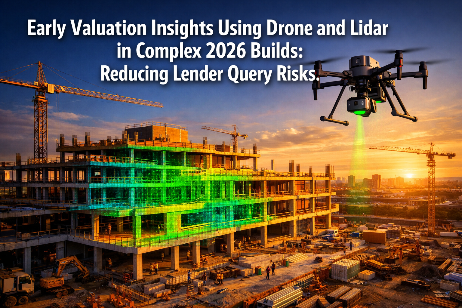
Early Valuation Insights Using Drone and Lidar in Complex 2026 Builds: Reducing Lender Query Risks represents more than technological advancement; it's a fundamental shift in how non-standard properties are assessed, documented, and financed. Traditional surveying methods struggle with irregular geometries, multi-phase developments, and the rapid pace of modern construction. Meanwhile, lenders require objective, measurable evidence that aligns with RICS-compliant reporting standards before releasing staged payments.
The convergence of drone technology, LiDAR scanning, artificial intelligence, and Building Information Modeling (BIM) now provides developers and surveyors with unprecedented tools to deliver the precise, verifiable data that lenders demand—while dramatically reducing assessment time and costs.
Key Takeaways
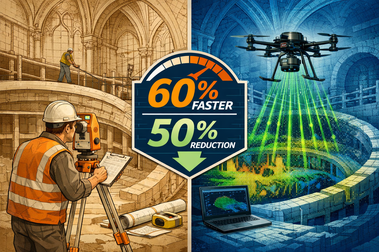
- LiDAR-equipped drones reduce manual survey costs by up to 50% and fieldwork time by 60%, enabling faster, more accurate valuations for complex builds [2]
- AI-powered point cloud analysis automatically detects geometric deviations to ±10mm tolerances, providing objective progress verification that satisfies lender requirements [3]
- The global LiDAR mapping drone market reached $105 million in 2024 and is projected to hit $185 million by 2034, driven by construction sector adoption [2]
- RICS-compliant reporting protocols now integrate drone and LiDAR data, streamlining the valuation process for non-standard properties during market recovery
- Periodic LiDAR scans registered with 4D BIM models enable automated completion percentages per trade, replacing subjective opinion-based progress reports with spatial evidence [3]
Understanding the Valuation Challenge in Complex 2026 Builds
Complex construction projects—those featuring irregular geometries, historic renovations, multi-phase developments, or innovative architectural designs—present unique challenges for traditional property valuation methods. Cathedral vaults, curved facades, underground structures, and intricate mechanical systems cannot be adequately assessed through visual inspection alone.
The Lender's Dilemma
Financial institutions face significant risk when funding complex builds. Unlike standard residential developments where valuation methodologies are well-established, non-standard properties require:
- Objective verification of construction progress against approved plans
- Accurate as-built documentation at multiple project stages
- Geometric precision measurements to confirm structural integrity
- Deviation detection to identify potential quality issues early
- Compliance evidence with building regulations and planning permissions
Traditional surveying approaches rely heavily on manual measurements, photographic evidence, and professional judgment. While expert building evaluation remains essential, these methods introduce subjectivity and time delays that increase lender query risks.
Market Recovery and Financing Pressures
The 2026 property market recovery has intensified competition for development financing. Lenders are more cautious following recent economic volatility, demanding stronger evidence before releasing staged payments. Developers face pressure to:
✅ Demonstrate measurable progress quickly
✅ Minimize documentation preparation time
✅ Reduce valuation disputes and payment delays
✅ Maintain cash flow throughout construction phases
✅ Provide transparent, verifiable reporting
This environment creates perfect conditions for technology adoption that bridges the gap between developer needs and lender requirements.
How Drone and LiDAR Technology Transforms Early Valuation Insights
The integration of drone-mounted LiDAR systems with advanced data processing represents a paradigm shift in construction monitoring and valuation. The drones in construction market reached $4.8 billion in 2024, ranking second among all industry verticals, with projected growth to $6.2 billion by 2030 [4]. This rapid adoption reflects the technology's proven value in addressing real-world challenges.
The Technical Foundation
LiDAR (Light Detection and Ranging) technology uses laser pulses to measure distances with millimeter-level precision. When mounted on drones, LiDAR systems can:
- Capture millions of data points per second across large construction sites
- Generate accurate 3D point clouds representing every surface and structure
- Penetrate vegetation and detect ground surfaces beneath
- Operate effectively in various lighting conditions, including low light
- Map irregular geometries that traditional methods cannot adequately document [3]
Professional-grade LiDAR mapping drone systems range from $25,000 to $150,000, with multirotor platforms becoming increasingly standard equipment [2]. While initial investment remains significant, the return on investment materializes through reduced survey costs, faster data collection, and minimized rework expenses.
The Valuation Workflow Revolution
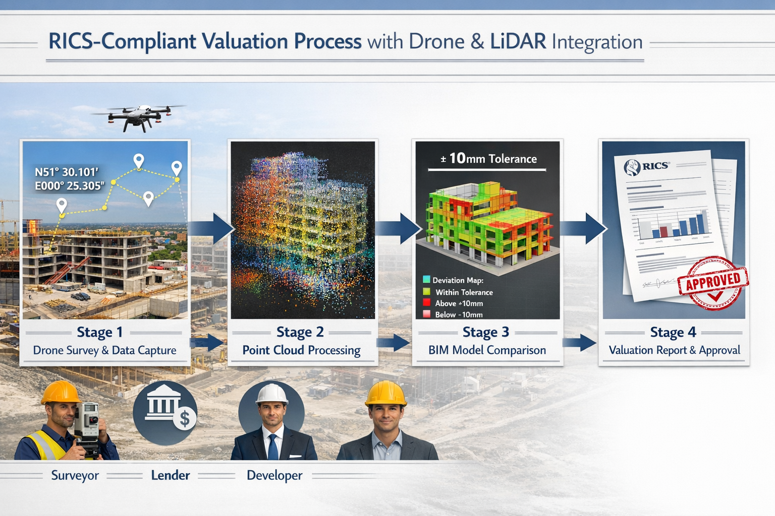
Early Valuation Insights Using Drone and Lidar in Complex 2026 Builds: Reducing Lender Query Risks manifests through a streamlined workflow that replaces weeks of traditional surveying with days of automated data capture and analysis:
Stage 1: Rapid Data Acquisition
Drone flights following pre-programmed paths capture comprehensive site data in hours rather than days. A typical complex build requiring 40+ hours of manual surveying can be documented in 2-4 hours of flight time [9].
Stage 2: Point Cloud Processing
Raw LiDAR data is processed into detailed 3D point clouds containing precise spatial information for every visible surface. Modern processing software handles datasets containing hundreds of millions of points.
Stage 3: BIM Integration and Analysis
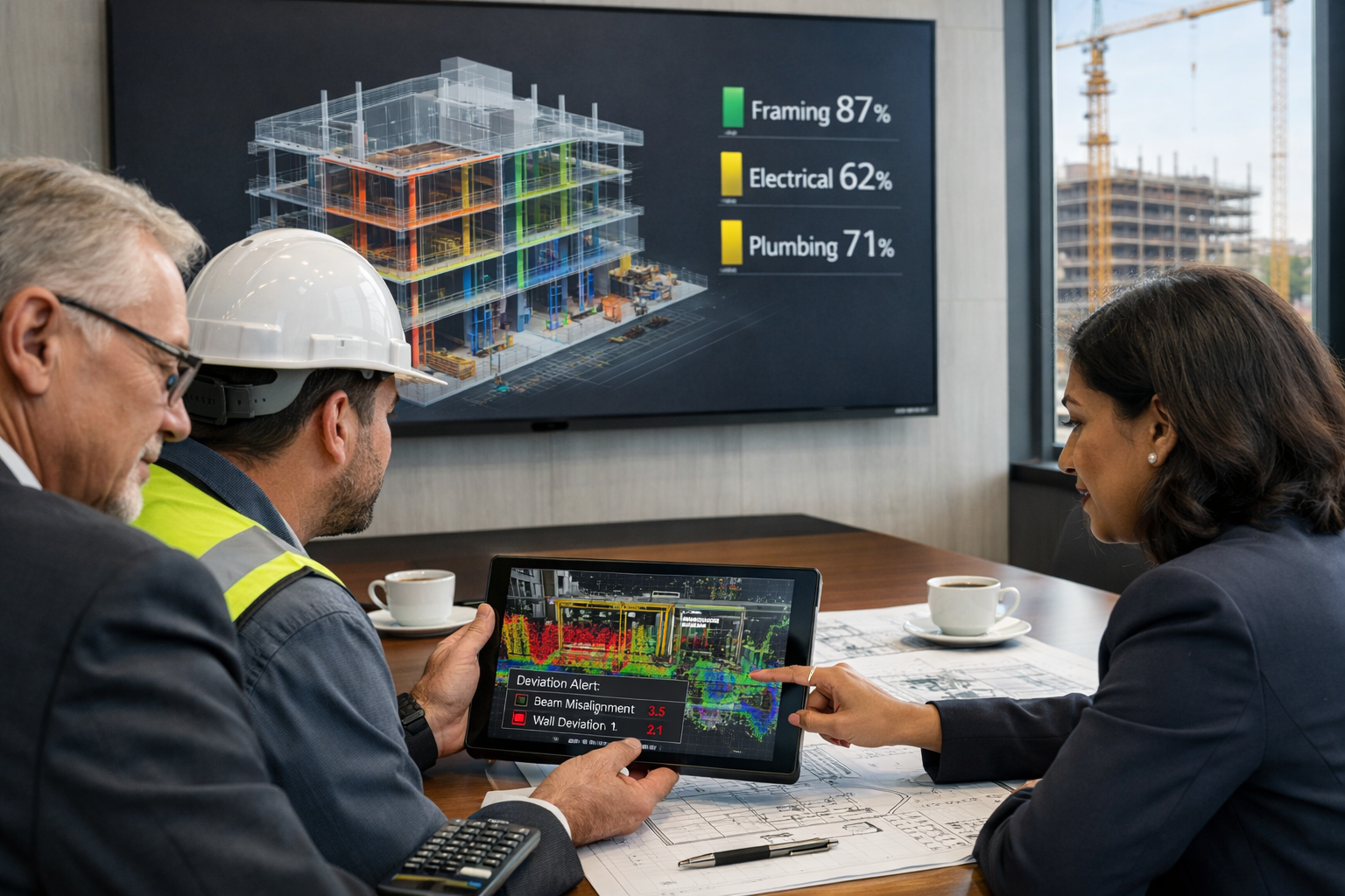
Point clouds are registered (aligned) with design BIM models, enabling automated comparison between planned and actual construction. AI-driven semantic segmentation automatically classifies construction elements such as walls, slabs, beams, ducts, and piping [3].
Stage 4: Deviation Detection and Reporting
Automated analysis identifies geometric deviations, generates completion percentages per trade, and produces visual heatmaps showing conformance to design specifications. These outputs form the foundation for RICS-compliant valuation reports.
Quantifiable Benefits for Complex Builds
The research evidence demonstrates compelling advantages:
| Metric | Traditional Method | Drone + LiDAR Method | Improvement |
|---|---|---|---|
| Survey Time | 40-60 hours | 2-4 hours | 60% reduction [2] |
| Cost per Survey | £8,000-£15,000 | £4,000-£7,500 | 50% reduction [2] |
| Measurement Accuracy | ±50mm typical | ±10mm or better | 5x improvement [3] |
| Data Completeness | Accessible areas only | Full site coverage | 100% coverage |
| Documentation Delay | 2-3 weeks | 3-5 days | 75% faster |
These improvements directly address the core causes of lender queries: incomplete documentation, measurement uncertainty, and delayed reporting.
Reducing Lender Query Risks Through RICS-Compliant Protocols
The Royal Institution of Chartered Surveyors (RICS) establishes professional standards for property valuation and surveying practice. Integrating drone and LiDAR technology into RICS-compliant workflows requires careful attention to methodology, documentation, and professional interpretation.
RICS Valuation Standards and Technology Integration
RICS valuation standards emphasize transparency, objectivity, and professional competence. Technology-enhanced valuations must maintain these principles while leveraging advanced data collection methods. Key considerations include:
Professional Oversight
Technology augments but does not replace professional judgment. Chartered surveyors must interpret LiDAR data within proper context, considering market conditions, construction quality, and project-specific factors. The surveyor's expertise remains central to defensible valuations.
Methodology Documentation
RICS-compliant reports must clearly document data collection methods, processing procedures, accuracy specifications, and any limitations. This transparency enables lenders to assess the reliability of technology-derived evidence.
Verification and Validation
Automated analysis outputs require verification through selective physical measurements and visual inspection. This hybrid approach combines technology efficiency with professional validation, creating robust evidence that withstands lender scrutiny.
Addressing Common Lender Concerns
Financial institutions evaluating technology-enhanced valuations typically raise specific questions that must be addressed through proper protocols:
🔍 Data Accuracy and Reliability
Lenders need confidence that LiDAR measurements accurately represent site conditions. Proper protocols include:
- Ground control point establishment with known coordinates
- Accuracy verification through independent measurements
- Quality assurance checks on point cloud density and coverage
- Documentation of environmental conditions during data capture
📊 Progress Verification Methodology
Periodic LiDAR scans registered with 4D BIM models enable automated completion percentages per trade [3], providing objective spatial evidence instead of opinion-based estimates. This approach addresses lender concerns about subjective progress reporting by linking actual site conditions to construction schedules through measurable geometric data.
⚖️ Professional Indemnity and Liability
Surveyors utilizing drone and LiDAR technology must ensure appropriate professional indemnity insurance coverage and maintain clear documentation of professional standards compliance. This protects all parties while enabling technology adoption.
🔐 Data Security and Archiving
Construction site data contains sensitive information about project design, progress, and potential issues. RICS-compliant protocols require secure data storage, appropriate access controls, and long-term archiving that supports future reference and dispute resolution.
The AI-Enhanced Quality Management Advantage
AI is now automating quality management by comparing LiDAR and drone scans against design models to automatically detect defects and deviations early [6], minimizing costly rework and enabling objective, measurable progress verification required by lenders for complex builds. This automated approach provides several advantages for reducing query risks:
Early Issue Detection
Geometric deviations identified during construction—rather than at completion—enable corrective action before problems compound. This proactive approach reduces the likelihood of valuation disputes and payment holdbacks.
Objective Evidence Base
Visual heatmaps showing conformance to design specifications provide clear, objective evidence that non-specialists can understand. Lenders reviewing progress claims can quickly assess whether construction aligns with approved plans.
Trend Analysis and Predictive Insights
Sequential LiDAR scans throughout construction phases enable trend analysis of construction quality and pace. Deviations from expected progress curves provide early warning of potential delays or quality issues that might affect final valuation.
Case Application: Complex Geometric Structures
Irregular geometries such as cathedral vaults, tunnels, and historic arches can only be reliably mapped with LiDAR [3]. For these challenging structures, traditional measurement methods introduce significant uncertainty that creates lender query risks.
Consider a 2026 mixed-use development incorporating historic facade preservation with modern interior construction. Traditional surveying struggles to:
- Accurately measure curved historic stonework
- Verify alignment between old and new structural elements
- Document hidden interfaces behind finished surfaces
- Prove compliance with conservation requirements
LiDAR scanning captures complete geometric data for both historic and new elements, enabling precise verification of structural integration. The resulting documentation provides lenders with confidence that complex construction meets design specifications and regulatory requirements.
For projects requiring monitoring surveys to track movement or settlement, periodic LiDAR scans provide millimeter-level change detection that traditional methods cannot match.
Implementation Strategies for 2026 Complex Builds
Successfully implementing Early Valuation Insights Using Drone and Lidar in Complex 2026 Builds: Reducing Lender Query Risks requires strategic planning that addresses technical, regulatory, and commercial considerations.
Pre-Construction Planning
Real estate developers adopting LiDAR technology early gain clearer feasibility insights and stronger project performance from day one [7], enabling better preliminary valuation and risk assessment before construction commencement. Effective implementation begins during project planning:
Baseline Documentation
Pre-construction LiDAR surveys establish accurate as-existing conditions, documenting site topography, adjacent structures, and any heritage elements. This baseline data supports:
- Accurate quantity takeoffs and cost estimation
- Clash detection between design and existing conditions
- Evidence for property condition assessment of adjacent properties
- Documentation protecting against future disputes
Lender Engagement
Early discussions with prospective lenders about technology-enhanced valuation protocols establish expectations and requirements. Topics should include:
- Preferred reporting formats and data deliverables
- Frequency of progress documentation
- Accuracy specifications and verification requirements
- Integration with existing lender monitoring systems
Regulatory Compliance
Drone operations require compliance with Civil Aviation Authority regulations, including operator certification, site-specific permissions, and safety protocols. Planning should address:
- Airspace restrictions and flight permissions
- Privacy considerations for adjacent properties
- Health and safety coordination with construction activities
- Insurance requirements for aerial operations
Construction Phase Implementation
Maximizing value from drone and LiDAR technology during construction requires systematic data collection aligned with project milestones and lender reporting requirements:
Scheduled Scanning Protocols
Periodic LiDAR scans (daily, weekly, or milestone-based) registered with design or 4D BIM models enable automated completion percentages per trade [3]. Typical scanning schedules include:
- Weekly scans for fast-track projects requiring frequent progress verification
- Milestone-based scans aligned with staged payment applications
- Event-driven scans following significant construction activities or when issues arise
- Final completion scans documenting as-built conditions
Data Processing and Analysis Workflow
Efficient workflows minimize time between data capture and actionable insights:
- Field data collection (2-4 hours for typical complex site)
- Point cloud processing (4-8 hours automated processing)
- BIM registration and analysis (4-6 hours with AI assistance)
- Report generation (2-4 hours for professional interpretation)
- Lender submission (same day or next day turnaround)
This compressed timeline—often completing in 1-2 days—contrasts sharply with traditional surveying requiring 2-3 weeks from initial site visit to final report.
Integration with Traditional Surveying
Technology enhancement works best when integrated with conventional property inspection methods rather than replacing them entirely. Hybrid approaches combine:
- LiDAR data for geometric accuracy and completeness
- Professional site visits for material quality assessment
- Photographic documentation for context and detail
- Specialist inspections for mechanical and electrical systems
Stakeholder Communication and Reporting
Effective communication translates technical data into actionable insights for diverse stakeholders:
For Lenders
Progress reports should emphasize:
- Clear completion percentages with supporting geometric evidence
- Deviation identification with impact assessment
- Compliance verification against approved plans
- Risk indicators requiring attention
For Developers and Contractors
Operational reporting focuses on:
- Quality control and deviation correction priorities
- Progress verification supporting payment applications
- Coordination issue identification for resolution
- Schedule impact analysis
For Professional Teams
Technical deliverables include:
- Registered point clouds for design coordination
- Clash detection reports for MEP coordination
- As-built documentation for facility management
- Digital twin foundations for asset management
Overcoming Adoption Barriers
Despite compelling benefits, several barriers can slow technology adoption:
💰 Initial Investment Costs
Professional-grade systems require significant capital investment. Options for managing costs include:
- Engaging specialist surveying firms with existing capabilities
- Equipment leasing or rental for specific projects
- Shared investment among project partners
- Phased implementation starting with pilot projects
🎓 Skills and Training Requirements
Effective use requires specialized knowledge in drone operation, LiDAR data processing, and BIM integration. Development strategies include:
- Professional training programs and certifications
- Partnerships with technology specialists
- Gradual capability building through supported projects
- Investment in younger professionals with digital skills
🏛️ Regulatory and Insurance Considerations
Navigating aviation regulations, professional standards, and insurance requirements requires careful attention. Success factors include:
- Early engagement with regulatory authorities
- Clear documentation of compliance procedures
- Professional indemnity insurance review and adjustment
- Legal advice on liability and data protection
The Future of Valuation Technology in Construction
Looking beyond 2026, the trajectory of drone and LiDAR technology in construction valuation points toward increasing automation, integration, and intelligence.
Emerging Technological Trends
Digital Twin Integration
Digital-twin-ready deliverables are becoming standard contract requirements [3], reflecting demand for geometry-driven asset management in complex builds. Future projects will increasingly maintain living digital twins—continuously updated 3D models reflecting actual asset conditions throughout the building lifecycle.
AI-Powered Predictive Analytics
Machine learning algorithms trained on thousands of construction projects will provide predictive insights about completion timelines, quality risks, and final valuations based on early-stage data patterns.
Real-Time Progress Monitoring
Automated drone flights and instant processing will enable real-time progress dashboards accessible to all stakeholders, fundamentally changing how projects are monitored and financed.
Blockchain-Based Verification
Immutable records of LiDAR scan data and analysis results stored on blockchain platforms will provide tamper-proof evidence chains supporting valuations and resolving disputes.
Market Growth and Adoption Trajectory
The global LiDAR mapping drone market was valued at $105 million in 2024 and is projected to reach $185 million by 2034 [2], representing 8.7% compound annual growth rate. This growth reflects increasing confidence in the technology's reliability and value.
Sector-specific adoption patterns reveal rapid uptake where value propositions are clearest. LiDAR drone adoption in mining has grown 32% year-over-year [2], indicating that industries facing similar challenges to complex construction—difficult terrain, safety concerns, measurement precision requirements—are embracing these solutions rapidly.
Governments worldwide are investing over $2 trillion annually in smart city initiatives [2], where drone-based LiDAR systems play crucial roles in 3D modeling and progress monitoring. This public sector investment accelerates technology maturation and drives down costs through economies of scale.
Implications for Professional Practice
The evolution of valuation technology will reshape professional surveying practice in several ways:
Specialization and Collaboration
The complexity of technology-enhanced valuations will drive specialization, with some practitioners focusing on data acquisition and processing while others concentrate on professional interpretation and reporting. Collaborative models will become increasingly common.
Continuous Professional Development
Maintaining professional competence will require ongoing investment in technology skills alongside traditional surveying expertise. Professional bodies including RICS are developing technology competency frameworks to support this evolution.
Value Proposition Evolution
As data collection becomes increasingly automated, professional value will shift toward interpretation, risk assessment, and strategic advice. Surveyors who successfully navigate this transition will find enhanced career opportunities and professional satisfaction.
Conclusion: Seizing the Opportunity in 2026
Early Valuation Insights Using Drone and Lidar in Complex 2026 Builds: Reducing Lender Query Risks represents a transformative opportunity for developers, surveyors, and financial institutions navigating the recovering property market. The convergence of mature drone technology, precise LiDAR scanning, AI-powered analysis, and RICS-compliant reporting protocols has created the perfect conditions for widespread adoption.
The evidence is compelling: 50% cost reductions, 60% time savings, millimeter-level accuracy, and objective progress verification that satisfies even the most cautious lenders [2][3]. For complex builds where traditional methods struggle—irregular geometries, multi-phase developments, historic renovations—these technologies provide capabilities that simply weren't possible before.
Actionable Next Steps
For developers and project sponsors:
- Evaluate current and planned projects for technology enhancement opportunities, prioritizing complex builds with higher lender query risks
- Engage with technology-capable surveying firms to understand capabilities, costs, and implementation requirements
- Discuss technology-enhanced protocols with lenders early in project planning to align expectations and requirements
- Consider pilot projects to build internal capabilities and demonstrate value before full-scale adoption
For surveyors and valuation professionals:
- Invest in technology capabilities through training, equipment acquisition, or strategic partnerships
- Develop RICS-compliant protocols that integrate drone and LiDAR data with professional standards
- Build case studies and evidence demonstrating value delivery and risk reduction
- Engage with professional bodies to contribute to evolving standards and best practices
For lenders and financial institutions:
- Review and update valuation requirements to accommodate technology-enhanced methodologies
- Establish clear acceptance criteria for drone and LiDAR-derived evidence
- Train credit and risk teams to understand and evaluate technology-based documentation
- Pilot technology-enhanced monitoring on selected complex projects to assess benefits
The 2026 construction landscape demands faster, more accurate, and more transparent valuation processes. Those who embrace Early Valuation Insights Using Drone and Lidar in Complex 2026 Builds will gain competitive advantages through reduced financing friction, faster project delivery, and stronger stakeholder confidence.
The technology is proven. The standards are established. The market is ready. The question is no longer whether to adopt these capabilities, but how quickly to implement them before competitors gain the advantage.
For guidance on implementing technology-enhanced valuation protocols for your complex build project, consult with experienced property surveyors who understand both traditional RICS standards and emerging technological capabilities. The future of construction valuation is here—and it's flying above your building site right now.
References
[1] Drone Lidar Workflow Gap Closing – https://www.commercialuavnews.com/drone-lidar-workflow-gap-closing
[2] Lidar Mapping Drone Market 30363 – https://www.intelmarketresearch.com/lidar-mapping-drone-market-30363
[3] 7 Reasons To Use Lidar Construction Laser Scanning – https://blog.brightergraphics.com/7-reasons-to-use-lidar-construction-laser-scanning
[4] Drones In Construction Market Analysis – https://droneii.com/drones-in-construction-market-analysis
[5] Technology For Early Property Insight In 2026 Building Surveys Reducing Delays In Complex Valuations – https://nottinghillsurveyors.com/blog/technology-for-early-property-insight-in-2026-building-surveys-reducing-delays-in-complex-valuations
[6] 2026 Ai Trends 25 Experts Share Insights – https://www.autodesk.com/blogs/construction/2026-ai-trends-25-experts-share-insights/
[7] Why Real Estate Developers Use Drone Lidar – https://collincountydrone.com/why-real-estate-developers-use-drone-lidar
[8] Construction Drone Market Forecast Points Higher Toward 2035 Driven By Digitalization Of Building Sites – https://www.digitalconstruction-now.com/article/315843/construction-drone-market-forecast-points-higher-toward-2035-driven-by-digitalization-of-building-sites
[9] Drone Mapping – https://uavcoach.com/drone-mapping/