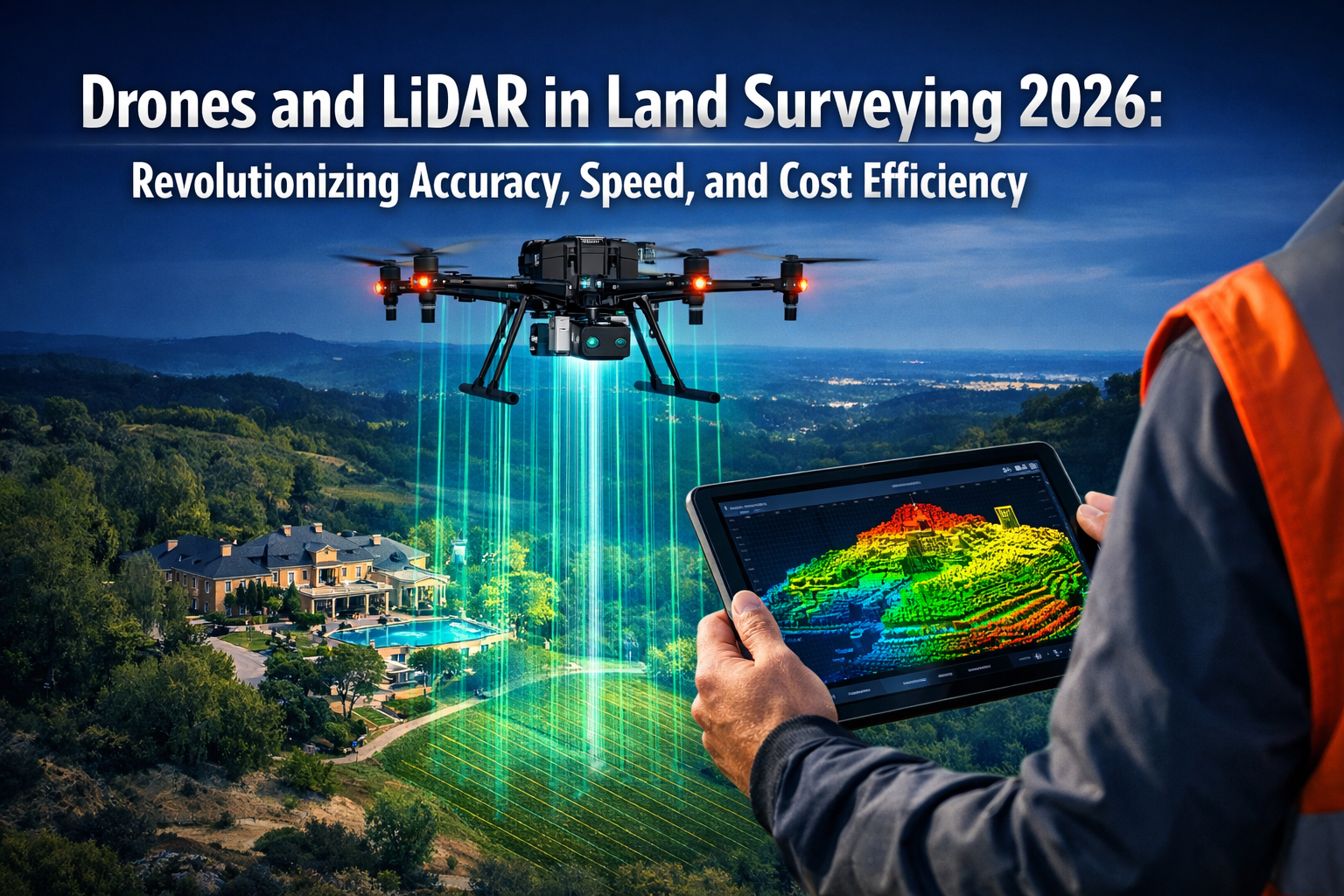
The land surveying industry stands at a pivotal moment in 2026. Traditional surveying methods that once took weeks to complete large property assessments are being replaced by advanced drone technology equipped with LiDAR sensors that can accomplish the same tasks in mere hours. This transformation isn't just about speed—it's fundamentally changing how surveyors approach accuracy, cost management, and project delivery across residential, commercial, and infrastructure applications.
Drones and LiDAR in Land Surveying 2026: Revolutionizing Accuracy, Speed, and Cost Efficiency represents more than a technological upgrade; it's a necessary evolution addressing critical industry challenges. With labor shortages continuing to constrain traditional surveying capacity and client expectations for faster turnaround times increasing, drone-based LiDAR systems have emerged as the solution that bridges the gap between demand and capability[2].
Key Takeaways
✅ Time Reduction: Modern drone LiDAR systems enable deployment in days rather than weeks or months, dramatically increasing project throughput and competitive capacity[2]
✅ Labor Gap Solution: Automated drone surveying addresses the industry's persistent labor shortage by enabling smaller teams to accomplish significantly more work[2]
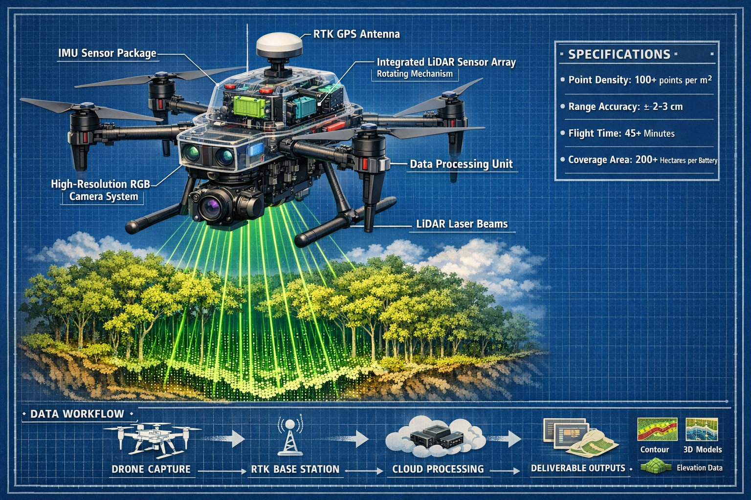
✅ Enhanced Accuracy: Current systems deliver improved resolution with higher point density (100+ points per square meter) and ±2-3cm accuracy, surpassing traditional methods in challenging terrain[1][4]
✅ Cost Efficiency: Professional survey drones priced between $15,000-$50,000 provide rapid ROI through increased project capacity and reduced field time[5]
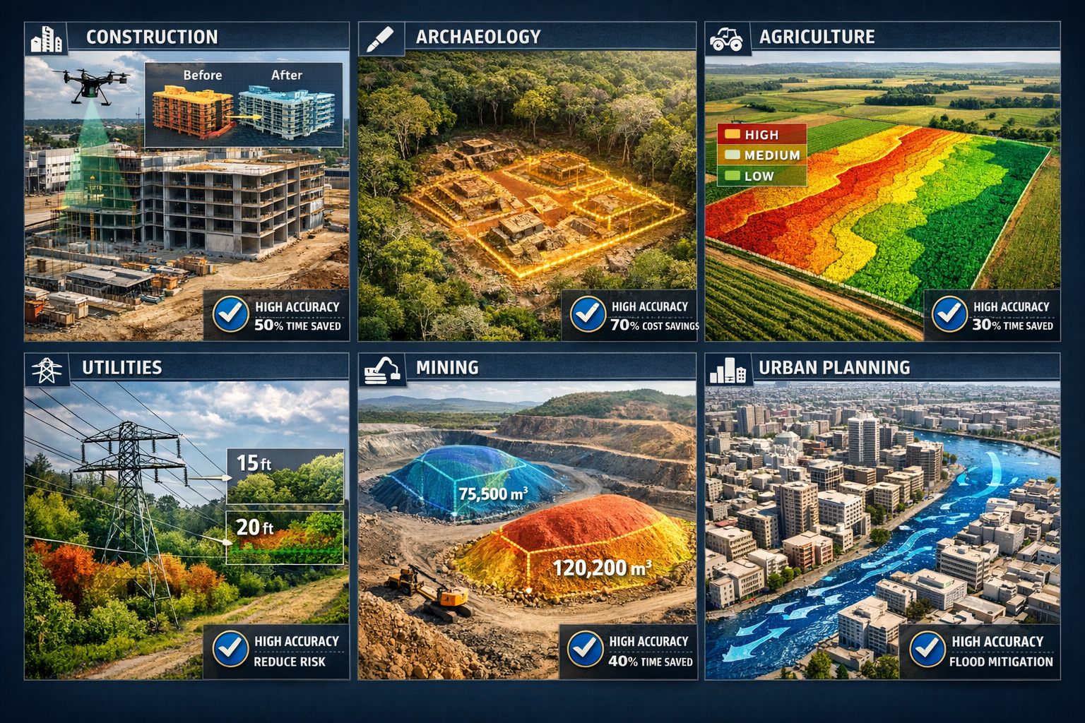
✅ Versatile Applications: LiDAR drones serve multiple industries including construction, archaeology, agriculture, utilities, and urban planning with specialized data outputs for each sector[1]
Understanding the Technology Behind Drones and LiDAR in Land Surveying 2026
What is LiDAR and How Does It Work?
LiDAR (Light Detection and Ranging) technology uses laser pulses to measure distances with extraordinary precision. When mounted on drones, these sensors emit thousands of laser pulses per second, which bounce off surfaces and return to the sensor. By calculating the time each pulse takes to return, the system creates a detailed three-dimensional point cloud representing the surveyed terrain.
The technology has matured significantly, transitioning from niche applications reserved for major infrastructure projects with substantial budgets to more accessible, accurate, and easier-to-process solutions across broader surveying applications[2][3]. This democratization of LiDAR technology means that even medium-sized surveying firms can now afford and effectively deploy these systems.
Integration of RTK GPS and Imaging Systems
Modern drone surveying systems integrate multiple technologies to maximize accuracy and usability:
- RTK (Real-Time Kinematic) GPS provides centimeter-level positioning accuracy
- High-resolution cameras capture detailed imagery alongside LiDAR data
- IMU (Inertial Measurement Unit) sensors track drone orientation and movement
- Integrated processing software combines all data streams into unified deliverables
These integrated systems have significantly reduced training requirements and field deployment complexity. Operators are now more likely to acquire correct data on first attempts, minimizing costly resurveys and project delays[2]. For surveyors conducting property assessments, this reliability translates directly into client confidence and business efficiency.
The Complementary Role of Photogrammetry
While LiDAR excels in penetrating vegetation and capturing ground-level detail, photogrammetry drones serve as cost-effective alternatives that should be deployed on virtually every project[2]. These systems use overlapping photographs to create 3D models and are particularly effective for:
- Open terrain with minimal vegetation
- Visual documentation requirements
- Projects with tighter budgets
- Rapid preliminary assessments
The combination of both technologies—using photogrammetry for initial assessments and LiDAR for detailed surveys in challenging conditions—represents best practice in 2026.
How Drones and LiDAR in Land Surveying 2026 Are Revolutionizing Large Property Assessments
Time Savings: From Weeks to Days
The most immediately apparent benefit of drone LiDAR technology is the dramatic reduction in field time. Consider a practical comparison:
| Survey Method | 50-Acre Wooded Property | 200-Acre Development Site | Urban Corridor (5 miles) |
|---|---|---|---|
| Traditional Ground Survey | 5-7 days | 3-4 weeks | 6-8 weeks |
| Drone LiDAR Survey | 4-6 hours | 1-2 days | 3-5 days |
| Time Reduction | 90%+ | 85%+ | 80%+ |
These time savings compound across multiple projects. A surveying firm that previously completed 20 major projects annually can now handle 60-80 projects with the same staff size, fundamentally transforming business capacity and revenue potential.
For clients requiring topographic surveys of large estates or development sites, this acceleration means faster project initiation, reduced holding costs, and quicker progression through planning and development phases.
Accuracy Improvements and Error Reduction
Precision matters in land surveying, where centimeter-level errors can result in costly construction mistakes, boundary disputes, or regulatory complications. Drone LiDAR systems in 2026 consistently achieve:
- Horizontal accuracy: ±2-3 cm with RTK correction
- Vertical accuracy: ±2-5 cm depending on terrain and vegetation
- Point density: 100-500 points per square meter (customizable based on project requirements)
This level of detail surpasses what's achievable with traditional methods in challenging terrain, particularly in:
🌲 Heavily vegetated areas where LiDAR penetrates canopy to capture ground surface
🏔️ Steep or dangerous terrain where ground-based surveying poses safety risks
🏗️ Active construction sites where ongoing work makes traditional surveying difficult
The improved resolution and higher point density deliver better imagery compared to traditional alternatives like satellite imagery or aerial photography, on a more timely basis[2]. When combined with professional property inspection guidance, these accurate surveys provide comprehensive property intelligence.
Cost Efficiency Analysis
While professional survey-grade drones with high-resolution cameras, RTK GPS, and professional-grade sensors are priced between $15,000-$50,000[5], the return on investment becomes apparent quickly:
Direct Cost Savings:
- Reduced field crew size (1-2 operators vs. 3-5 traditional surveyors)
- Lower equipment transportation costs
- Minimal setup and breakdown time
- Reduced safety equipment and insurance costs for hazardous terrain
Indirect Financial Benefits:
- Increased project capacity (3-4x more projects annually)
- Faster invoicing and cash flow
- Competitive advantage in bid processes
- Reduced liability from survey errors
- Lower training costs for new staff
A mid-sized surveying firm investing $35,000 in a professional drone LiDAR system typically achieves full ROI within 6-12 months through increased project volume alone, not accounting for the competitive advantages and client satisfaction improvements.
Case Study: Residential Estate Boundary Survey
A recent project involving a 75-acre residential estate with mixed woodland and open areas demonstrates the practical advantages:
Traditional Method Estimate:
- Field time: 8-10 days with 3-person crew
- Processing time: 3-4 days
- Total cost: £12,000-£15,000
- Timeline: 3 weeks
Drone LiDAR Actual Results:
- Field time: 6 hours with 2-person crew
- Processing time: 1 day (automated workflows)
- Total cost: £4,500
- Timeline: 3 days
- Client savings: 70% cost reduction, 85% time reduction
The LiDAR data also revealed previously unknown drainage features and subtle elevation changes that informed the client's development planning, adding unexpected value beyond the basic boundary survey. For property owners dealing with boundary disputes, this level of detail provides definitive evidence for resolution.
Multi-Industry Applications of Drones and LiDAR in Land Surveying 2026
Construction and Infrastructure Development
In the construction sector, drone LiDAR enables real-time progress tracking and quality control that was previously impossible or prohibitively expensive[1]. Project managers can:
- Compare as-built conditions against design models weekly or daily
- Identify grading errors before they become costly problems
- Calculate earthwork volumes with 98%+ accuracy
- Monitor stockpile quantities for materials management
- Document site conditions for dispute resolution
Major infrastructure projects now routinely incorporate drone surveys at multiple project phases, from initial site assessment through final as-built documentation. This continuous monitoring approach catches problems early when corrections cost thousands rather than millions.
Archaeological and Heritage Site Documentation
LiDAR drones have revolutionized archaeology by enabling non-invasive exploration and documentation of archaeological sites[1]. The technology reveals hidden structures beneath vegetation and soil while preserving site integrity—a capability impossible with traditional excavation methods.
Recent applications include:
- Discovering previously unknown ancient settlements beneath forest canopy
- Mapping entire archaeological sites in days rather than years
- Creating detailed 3D models for virtual museum exhibits
- Monitoring heritage site degradation over time
- Planning excavation strategies with minimal ground disturbance
This non-destructive approach aligns with modern archaeological ethics while dramatically accelerating discovery and documentation.
Agricultural Optimization and Precision Farming
High-resolution LiDAR data supports precision agriculture by mapping terrain and soil characteristics to optimize planting patterns and irrigation, directly enhancing crop yields and resource efficiency[1]. Farmers and agricultural consultants use drone LiDAR for:
- Micro-topography mapping for precision drainage design
- Irrigation system planning based on exact elevation data
- Soil erosion monitoring and prevention
- Crop health correlation with terrain features
- Yield prediction modeling
The ability to identify subtle elevation changes (±2-3cm accuracy) allows for irrigation designs that maximize water efficiency—increasingly critical as water resources become scarcer and more expensive.
Utilities and Infrastructure Inspection
Utility companies have rapidly adopted drone LiDAR for pipeline and power line inspection[1], replacing dangerous manual inspections with safer, faster, and more comprehensive surveys. Applications include:
- Vegetation encroachment analysis around power lines
- Pipeline corridor monitoring for ground movement
- Asset inventory and condition assessment
- Emergency response and damage assessment
- Right-of-way management and planning
A single drone operator can survey 20-30 miles of utility corridor in a day—work that would take weeks using traditional methods and expose workers to significant safety risks.
Urban Planning and Smart City Development
Urban planners leverage drone LiDAR for comprehensive city modeling that informs infrastructure decisions, flood risk assessment, and development planning[1]. The technology provides:
- Detailed 3D city models for visualization and analysis
- Stormwater flow modeling based on precise elevation data
- Heat island mapping when combined with thermal imaging
- Transportation corridor planning and optimization
- Heritage building documentation and preservation
Cities implementing smart city initiatives find drone LiDAR data essential for creating the digital twins that underpin modern urban management systems. When planning construction projects in urban environments, this comprehensive spatial data prevents conflicts and optimizes design.
Mining and Quarry Operations
Mining operations use drone LiDAR for mineral deposit mapping and operational monitoring[1], achieving:
- Stockpile volume calculations with ±1-2% accuracy
- Pit progression monitoring and planning
- Safety compliance documentation
- Reclamation planning and monitoring
- Blast planning and analysis
The ability to survey active mining operations without stopping work or exposing personnel to hazards represents a significant safety and productivity improvement over traditional methods.
The Current State of the Drone Surveying Market in 2026
Market Concentration and Industry Leadership
The commercial drone surveying market has experienced significant consolidation, with market concentration reaching 70-90% control by leading providers, with even higher percentages in certain subsectors approaching 100%[2]. This concentration reflects the technical expertise, regulatory compliance, and capital investment required to deliver professional-grade drone surveying services consistently.
This market structure benefits clients through:
- Standardized workflows and deliverable formats
- Proven reliability and quality assurance
- Comprehensive insurance and liability coverage
- Ongoing technology investment and innovation
- Extensive operator training and certification programs
For surveying firms considering drone adoption, partnering with established providers or investing in comprehensive training programs has become essential for competitive positioning.
Regulatory Framework Developments
The regulatory environment continues evolving to accommodate expanding drone capabilities. A framework allowing surveyors to fly larger drones is likely to be published with an effective date expected later in 2026[2], which will enable:
- Longer flight times and greater coverage per deployment
- Heavier sensor payloads for enhanced data quality
- Operations in more challenging weather conditions
- Extended range operations with improved safety margins
These regulatory advances will further improve the economics and capabilities of drone surveying, making the technology accessible to even smaller firms and expanding its application range.
Technology Accessibility and Training Requirements
The barrier to entry for drone surveying has decreased substantially as integrated systems reduce complexity. Modern platforms feature:
- Automated flight planning that optimizes coverage and battery usage
- Real-time data quality monitoring that alerts operators to potential issues
- Simplified post-processing workflows with cloud-based automation
- Intuitive control interfaces that reduce training time from months to weeks
However, professional competency still requires significant investment in training, particularly for understanding:
- Survey-grade accuracy requirements and validation
- Data processing and quality control procedures
- Regulatory compliance and airspace management
- Client communication and deliverable specifications
Firms investing in comprehensive training programs achieve significantly better outcomes than those attempting to minimize training costs. For surveyors expanding their service offerings, understanding what surveyors do in this evolving technological landscape becomes increasingly important.
Implementing Drone LiDAR Technology: Practical Considerations
Equipment Selection and Investment Planning
Choosing appropriate drone LiDAR equipment requires careful analysis of:
Project Requirements:
- Typical survey area sizes and terrain types
- Required accuracy levels and point density
- Deliverable formats (point clouds, contours, 3D models)
- Industry-specific applications and compliance needs
Budget Considerations:
- Initial equipment investment ($15,000-$50,000 for professional systems)[5]
- Annual maintenance and insurance costs
- Software licensing and cloud processing fees
- Training and certification expenses
- Backup equipment and spare parts inventory
Scalability Planning:
- Growth trajectory and projected project volume
- Technology upgrade cycles and obsolescence risk
- Staffing requirements and training capacity
- Market positioning and competitive differentiation
Many firms find that starting with photogrammetry systems and adding LiDAR capabilities as project demand justifies the investment provides a lower-risk pathway to full drone surveying capability.
Workflow Integration and Process Optimization
Successful drone surveying implementation requires integrating new workflows with existing processes:
- Pre-flight Planning: Site assessment, airspace authorization, weather monitoring, safety planning
- Field Operations: Equipment setup, flight execution, real-time quality monitoring, data backup
- Data Processing: Point cloud generation, accuracy validation, deliverable creation, quality control
- Client Delivery: Format conversion, visualization, documentation, training on data usage
Firms achieving the best results establish standard operating procedures for each workflow stage, ensuring consistency regardless of which team member executes the project. This systematization enables quality assurance and facilitates staff training.
Quality Assurance and Accuracy Validation
Professional drone surveying requires rigorous quality control:
- Ground control points (GCPs): Surveyed reference points that validate drone data accuracy
- Check points: Independent verification points that confirm overall survey quality
- Point cloud analysis: Statistical validation of point density, coverage, and noise levels
- Deliverable review: Systematic checking of final products against client specifications
Establishing documented QA procedures protects against errors and provides evidence of professional standards for liability purposes. When conducting property valuations or boundary determinations, this quality assurance becomes legally significant.
Insurance and Liability Management
Drone surveying introduces specific insurance considerations:
- Aviation liability insurance: Coverage for drone operations and third-party damage
- Professional indemnity insurance: Protection against survey errors and omissions
- Equipment insurance: Coverage for drone loss, damage, or theft
- Data liability insurance: Protection against data breaches or loss
Working with insurance providers experienced in drone surveying ensures appropriate coverage levels and helps identify risk management strategies that may reduce premiums.
Future Trends: Where Drones and LiDAR in Land Surveying Are Heading
Artificial Intelligence and Automated Feature Extraction
The next evolution in drone surveying involves AI-powered automated analysis that extracts meaningful information from raw point cloud data:
- Automatic building footprint extraction
- Vegetation classification and biomass calculation
- Infrastructure asset identification and inventory
- Change detection between survey epochs
- Defect identification in structures and pavements
These capabilities will further reduce processing time and enable surveyors to deliver higher-value analytical products rather than just raw data.
Enhanced Sensor Integration
Future drone platforms will integrate additional sensors for comprehensive site characterization:
- Thermal imaging for heat loss detection and moisture identification
- Multispectral sensors for vegetation health and environmental monitoring
- Ground-penetrating radar for subsurface feature detection
- Gas sensors for environmental compliance and safety monitoring
This multi-sensor approach will position drone surveys as comprehensive site intelligence platforms rather than simple measurement tools.
Autonomous Operations and Beyond Visual Line of Sight (BVLOS)
Regulatory frameworks are gradually enabling autonomous drone operations and BVLOS flights, which will:
- Enable single operators to manage multiple simultaneous surveys
- Allow continuous monitoring of linear infrastructure (pipelines, roads, railways)
- Reduce operational costs through minimized human supervision
- Enable rapid emergency response and disaster assessment
These capabilities will further amplify the productivity advantages that drones already provide.
Real-Time Processing and Edge Computing
Advances in onboard processing power will enable real-time data processing during flight operations:
- Immediate accuracy validation without returning to office
- Adaptive flight path adjustment based on data quality
- Instant preliminary deliverables for time-critical decisions
- Reduced data transfer requirements through edge processing
This real-time capability will be particularly valuable for construction monitoring and emergency response applications where immediate information drives critical decisions.
Overcoming Common Challenges and Misconceptions
Weather and Environmental Limitations
Challenge: Drone operations face weather constraints including wind, rain, and extreme temperatures.
Reality: Modern professional drones operate safely in winds up to 25-30 mph and light rain. Strategic scheduling and weather monitoring minimize weather-related delays. Most projects experience less than 10% weather-related postponements when properly planned.
Data Processing Complexity
Challenge: Processing LiDAR data requires specialized expertise and powerful computing resources.
Reality: Cloud-based processing platforms have dramatically simplified workflows. Modern systems provide automated processing with quality validation, reducing skilled labor requirements. Processing that once required dedicated workstations now runs on standard laptops or cloud services.
Regulatory Compliance Burden
Challenge: Drone regulations seem complex and constantly changing.
Reality: Established regulatory frameworks in most jurisdictions provide clear operating rules. Professional drone operators maintain current certifications and airspace authorizations as routine business practice. Compliance becomes systematic rather than burdensome with proper procedures.
Initial Investment Concerns
Challenge: The upfront cost of professional drone systems appears prohibitive.
Reality: ROI analysis consistently shows 6-12 month payback periods for active surveying firms. Financing options, phased implementation approaches, and service partnerships provide alternatives to large capital outlays. The cost of not adopting drone technology—lost competitive positioning and limited capacity—often exceeds the investment cost.
For firms evaluating whether drone surveying makes financial sense, comparing the investment against property survey expenses using traditional methods reveals compelling economics.
Best Practices for Maximizing Value from Drone LiDAR Surveys
Client Communication and Expectation Management
Successful drone surveying projects begin with clear client communication:
✅ Explain capabilities and limitations: Help clients understand what drone surveys can and cannot deliver
✅ Define deliverable specifications early: Confirm required accuracy, formats, and data products before fieldwork
✅ Provide timeline transparency: Communicate realistic schedules including weather contingencies
✅ Offer data usage training: Help clients maximize value from the comprehensive data they receive
Clients who understand the technology become advocates who refer additional business and accept premium pricing for superior service.
Continuous Professional Development
The rapid evolution of drone surveying technology requires ongoing learning:
- Attend industry conferences and training workshops
- Participate in manufacturer certification programs
- Join professional associations and user groups
- Experiment with new processing techniques and software
- Share knowledge within your organization
Firms that prioritize continuous learning maintain competitive advantages and avoid obsolescence as technology evolves.
Strategic Service Positioning
Position drone surveying services strategically within your overall business:
- Premium positioning: Emphasize speed, accuracy, and comprehensive data as value justification
- Niche specialization: Develop expertise in specific applications (heritage documentation, construction monitoring, etc.)
- Complementary services: Bundle drone surveys with traditional services for comprehensive solutions
- Geographic expansion: Use drone efficiency to serve wider geographic areas profitably
The most successful firms view drone technology as enabling strategic business evolution rather than simply replacing existing methods.
Conclusion: Embracing the Revolution in Land Surveying
Drones and LiDAR in Land Surveying 2026: Revolutionizing Accuracy, Speed, and Cost Efficiency is not hyperbole—it's an accurate description of the transformation reshaping the surveying profession. The technology has matured from experimental novelty to essential business tool, addressing critical industry challenges including labor shortages, client demands for faster delivery, and competitive pressure on pricing.
The evidence is compelling: 90%+ time reductions, 70%+ cost savings, and accuracy improvements that exceed traditional methods in challenging conditions[2][5]. These aren't theoretical benefits—they're demonstrated outcomes from thousands of projects across residential, commercial, infrastructure, and specialized applications.
For surveying professionals, the question is no longer whether to adopt drone technology but how quickly and comprehensively to implement it. Firms that have embraced drone surveying report transformational business impacts: dramatically increased project capacity, improved client satisfaction, enhanced competitive positioning, and new service opportunities previously unavailable.
For property owners, developers, and project managers requiring surveying services, understanding this technology revolution enables better vendor selection and more informed expectations. The comprehensive data, rapid turnaround, and cost efficiency that drone LiDAR surveys provide translate directly into better project outcomes and faster development timelines.
Actionable Next Steps
For Surveying Professionals:
- Assess your current project mix to identify which applications would benefit most from drone surveying
- Research equipment options appropriate to your budget and project requirements
- Invest in comprehensive training through manufacturer programs or professional associations
- Start with pilot projects to develop competency before marketing services broadly
- Develop standard operating procedures for quality assurance and workflow efficiency
- Update insurance coverage to address drone operations and professional liability
For Property Owners and Developers:
- Request drone survey options when soliciting proposals for large property assessments
- Compare deliverables and timelines between traditional and drone-based approaches
- Verify operator credentials including aviation certifications and professional surveying licenses
- Understand data formats and ensure compatibility with your design and planning software
- Leverage comprehensive data for multiple purposes beyond the immediate survey need
- Consider ongoing monitoring services for construction projects or environmental compliance
The revolution in land surveying is well underway in 2026, driven by accessible technology, proven results, and compelling economics. Whether you're a surveying professional adapting to new tools or a client seeking superior service, understanding and embracing these advances positions you for success in an increasingly competitive and demanding marketplace.
The future of land surveying combines the precision and professional standards of traditional practice with the speed, efficiency, and comprehensive data that only drone LiDAR technology can provide. Those who master this combination will define the profession's next chapter.
References
[1] Lidar Drones – https://uavcoach.com/lidar-drones/
[2] Watch – https://www.youtube.com/watch?v=CSTodaZb4Vc
[3] Webinar The State Of Drone Surveying A Strategic Briefing For 2026 – https://www.aerotas.com/blog/webinar-the-state-of-drone-surveying-a-strategic-briefing-for-2026
[4] Start 2026 With A Smarter Way To Add Drone Lidar To Your Workflow – https://www.laserinst.com/news/start-2026-with-a-smarter-way-to-add-drone-lidar-to-your-workflow/
[5] Revolutionizing Land Surveying The Rise Of Drone Technology And Uav Applications In 2026 – https://nottinghillsurveyors.com/blog/revolutionizing-land-surveying-the-rise-of-drone-technology-and-uav-applications-in-2026