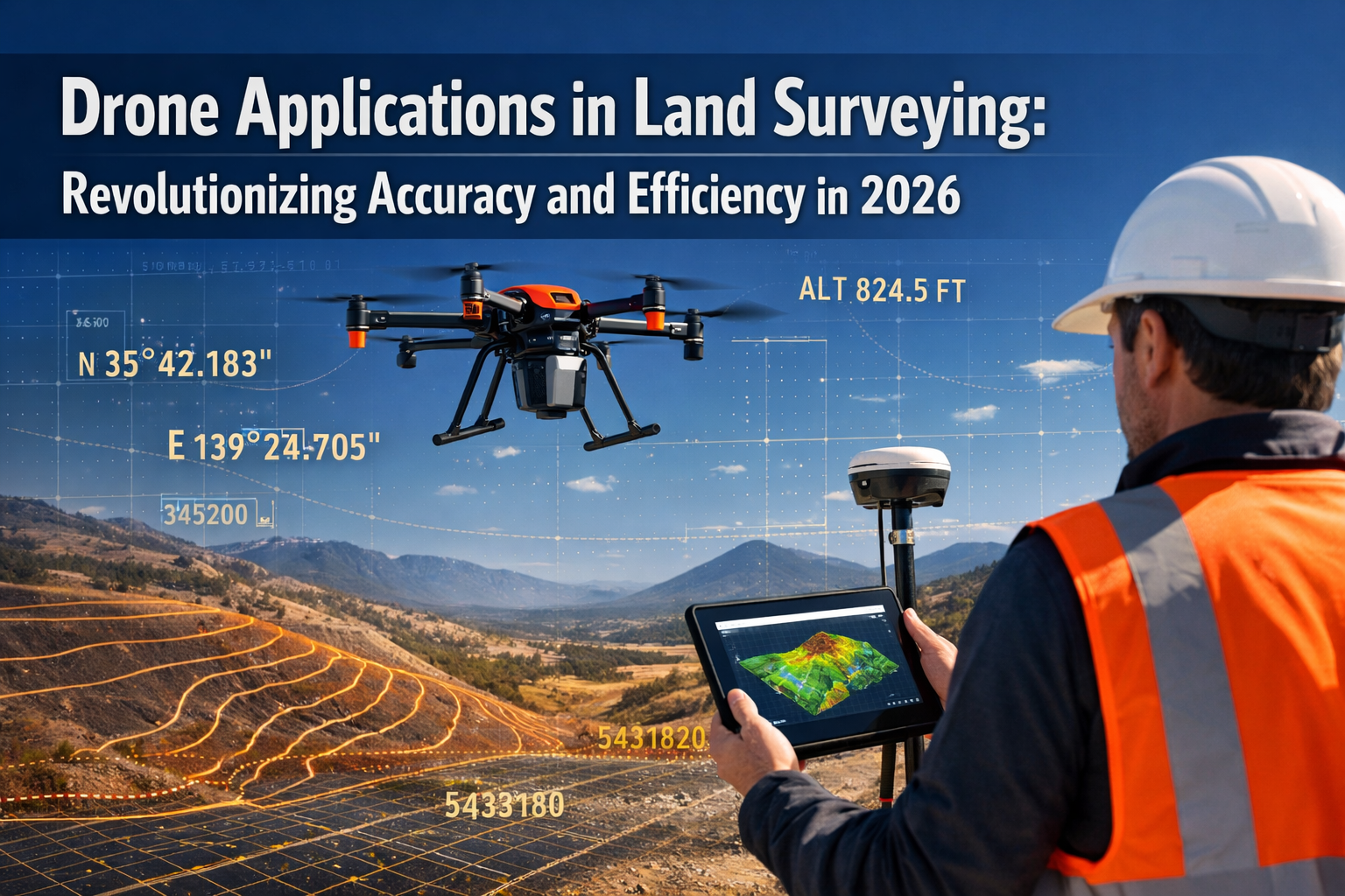
The landscape of land surveying has undergone a dramatic transformation. Picture a surveyor who once spent weeks trudging through difficult terrain with heavy equipment, now completing the same project in mere hours with a drone that fits in a backpack. This isn't science fiction—it's the reality of Drone Applications in Land Surveying: Revolutionizing Accuracy and Efficiency in 2026. Modern survey drones equipped with LiDAR sensors and high-resolution cameras are delivering centimeter-level precision while slashing costs and timelines, fundamentally changing how professionals approach topographic mapping, construction monitoring, and land analysis across every industry.
As we navigate through 2026, the integration of drone technology into surveying workflows has moved beyond experimental adoption to become an essential tool for professionals worldwide. From construction sites in urban centers to remote mining operations, drones are proving indispensable for capturing accurate, real-time data that drives better decision-making and project outcomes.
Key Takeaways
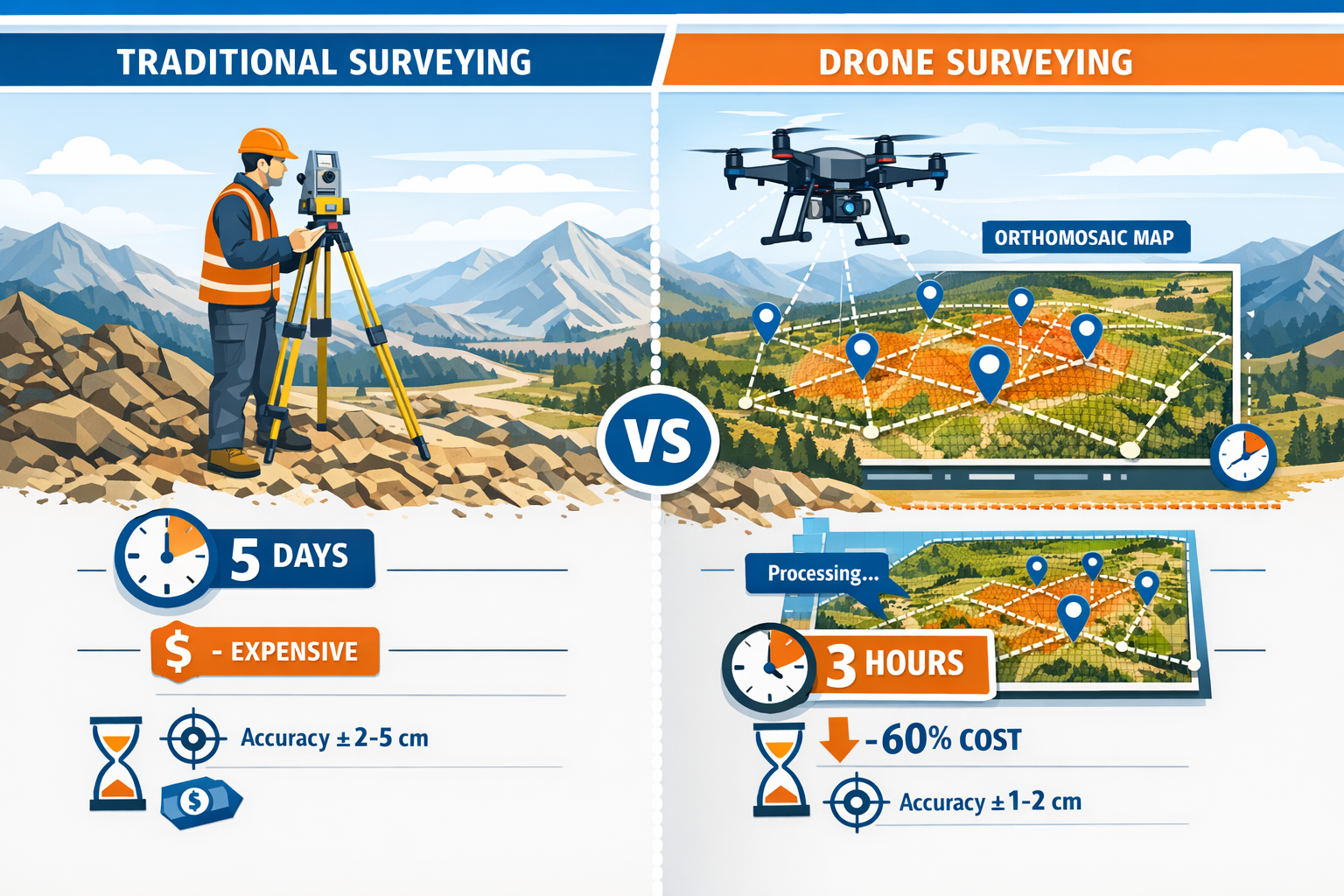
✈️ Dramatic Time Reduction: Drone surveys reduce project timelines from days or weeks to just hours, enabling faster decision-making and accelerated project progression across all industries.[2]
📊 Centimeter-Level Precision: Modern survey drones equipped with PPK technology and high-resolution sensors deliver centimeter-level accuracy without requiring ground control points in many applications.[3][5]
💰 Cost-Effective Operations: Drone surveying significantly reduces operational costs compared to traditional methods, with small teams capable of covering large areas by operating multiple drones with a single controller.[2][4]
🌲 LiDAR Breakthrough: LiDAR-equipped drones penetrate dense vegetation to produce highly accurate 3D models, revealing hidden terrain features and enabling applications from archaeology to carbon storage monitoring.[2]
📈 DaaS Model Growth: Drones as a Service (DaaS) is becoming the preferred solution for industries requiring accurate, real-time data, with companies scaling operations across multiple markets throughout 2026.[1]
Understanding Modern Drone Surveying Technology
The technological foundation of Drone Applications in Land Surveying: Revolutionizing Accuracy and Efficiency in 2026 rests on sophisticated sensor systems and data processing capabilities that were unimaginable just a decade ago. Today's survey drones represent a convergence of multiple advanced technologies working in harmony to capture and process geospatial data with unprecedented accuracy.
Core Sensor Technologies
Modern survey drones typically operate with downward-facing sensors that capture different types of data depending on project requirements. These sensors fall into several categories, each serving specific surveying needs:
RGB Cameras: High-resolution cameras capture detailed visual imagery that photogrammetry software processes into orthomosaic maps and 3D models. The latest cameras deliver resolutions exceeding 20 megapixels, enabling identification of features as small as a few centimeters from appropriate altitudes.[3]
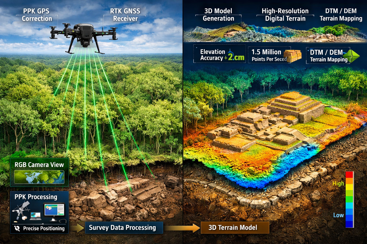
LiDAR Sensors: Light Detection and Ranging technology has revolutionized surveying in challenging environments. LiDAR sensors emit laser pulses that bounce off surfaces and return to the sensor, measuring distances with extraordinary precision. The breakthrough capability of LiDAR is its ability to penetrate dense vegetation, revealing ground surfaces beneath tree canopies that traditional cameras cannot see.[2]
Multispectral Sensors: These specialized cameras capture data beyond the visible spectrum, particularly valuable for agricultural applications where they assess crop health, irrigation needs, and vegetation analysis.[2]
Thermal Sensors: Infrared cameras detect temperature variations, useful for infrastructure inspections, identifying moisture intrusion, and monitoring industrial facilities.[3]
Positioning and Accuracy Technologies
The accuracy revolution in drone surveying stems from advanced positioning technologies that eliminate traditional limitations:
PPK (Post-Processed Kinematic): This technology represents a game-changer for survey efficiency. PPK systems record precise positioning data during flight, which is later processed against base station data to achieve centimeter-level accuracy without requiring ground control points in many applications.[5] This eliminates the time-consuming process of placing and surveying physical markers across the site.
RTK (Real-Time Kinematic): RTK systems provide real-time corrections during flight, enabling immediate centimeter-level positioning. While requiring more complex setup than PPK, RTK delivers instant results for time-sensitive projects.[3]
GIS Integration: Geographic Information Systems process the raw data captured by drone sensors, transforming it into actionable intelligence. Modern workflows integrate seamlessly with CAD and BIM platforms, enabling direct use of survey data in design and engineering applications.[2]
Data Output Formats
Survey drones generate multiple data products, each serving different analytical purposes:
| Output Type | Description | Primary Applications |
|---|---|---|
| Orthomosaic Maps | Geometrically corrected aerial images | Site planning, cadastral mapping, change detection |
| 3D Point Clouds | Millions of georeferenced points | Volumetric calculations, terrain modeling, BIM integration |
| Digital Elevation Models (DEMs) | Bare-earth terrain representations | Hydrology analysis, grading plans, flood modeling |
| Digital Surface Models (DSMs) | Surface including vegetation and structures | Urban planning, line-of-sight analysis, solar potential |
| Thermal Maps | Temperature distribution imagery | Infrastructure inspection, moisture detection, energy audits |
| Multispectral Datasets | Multi-band spectral information | Vegetation health, crop monitoring, environmental assessment |
The ability to generate these diverse outputs from a single flight represents tremendous efficiency gains compared to traditional surveying methods that would require multiple separate data collection efforts.
How Drone Applications in Land Surveying Are Revolutionizing Industry Workflows
The practical implementation of Drone Applications in Land Surveying: Revolutionizing Accuracy and Efficiency in 2026 varies significantly across different sectors, each leveraging drone technology to solve industry-specific challenges. Understanding these applications reveals why drones have become indispensable tools rather than optional enhancements.
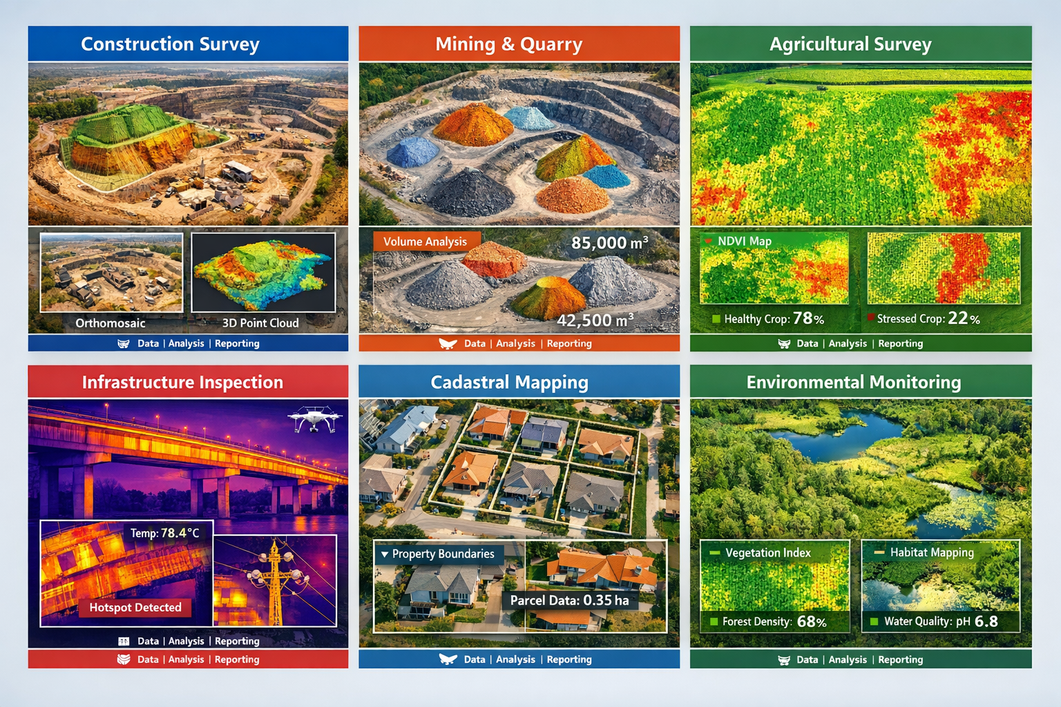
Construction and Infrastructure Development
Construction projects benefit enormously from drone surveying throughout the entire project lifecycle. During the pre-construction phase, drones capture detailed topographical data that engineers use to create accurate site models for design and planning. These aerial surveys construct intricate topographical models for engineering evaluations, integrating seamlessly with CAD or BIM platforms.[2]
Throughout construction, periodic drone surveys monitor progress and verify alignment with design specifications in real-time. Project managers can identify deviations early, preventing costly corrections later. The ability to generate 2D orthomosaics in real-time allows teams to immediately visualize land cover and identify changes without waiting for post-processing.[4]
Infrastructure features including signage, curbs, hydrants, and drainage systems are distinctly identified in drone surveys, creating comprehensive as-built documentation.[2] This level of detail supports facilities management long after construction completion.
For professionals seeking comprehensive property evaluations, understanding different survey types remains essential. Our guide on home survey levels 2 vs level 3 explains various assessment approaches for different property needs.
Mining and Quarrying Operations
Mining operations have embraced drone technology for both operational efficiency and safety improvements. Drones provide detailed, up-to-date maps and 3D models of mining sites without exposing personnel to hazardous areas.[2]
One of the most valuable applications involves stockpile monitoring and volume calculations. LiDAR-equipped drones accurately measure stockpile volumes for inventory management, eliminating the need for manual measurements that are both time-consuming and potentially dangerous.[5] These calculations directly impact financial reporting and operational planning.
Quarry operators use drone surveys to:
- Monitor pit progression and plan extraction sequences
- Calculate material volumes for sales and inventory
- Assess slope stability and identify potential hazards
- Document site conditions for regulatory compliance
- Plan haul road layouts and optimize logistics
The ability to conduct these surveys frequently—even weekly or daily if needed—provides operational insights that were previously impossible to obtain cost-effectively.
Agricultural Land Management
Agricultural applications of drone surveying extend far beyond simple field mapping. Farmers and agricultural consultants use multispectral drone imagery to assess crop health, irrigation needs, and land optimization opportunities.[2]
Vegetation indices calculated from multispectral data reveal stress patterns invisible to the naked eye, enabling targeted interventions before problems become widespread. Thermal imaging identifies irrigation system failures and water distribution issues. Elevation models guide drainage improvements and precision grading.
The economic impact is substantial: early detection of crop stress, optimized input application, and improved water management all contribute to increased yields and reduced costs.
Cadastral and Boundary Surveying
Land mapping has been transformed by drone technology's ability to generate sharp orthomosaics and intricate 3D representations of areas, enabling swift creation of highly precise cadastral maps even in challenging or remote environments.[2]
Traditional boundary surveys require surveyors to physically access every corner and feature, a process that can take days or weeks in large or difficult properties. Drones capture comprehensive imagery of entire properties in hours, providing context and detail that supports boundary determination and dispute resolution.
For property owners dealing with boundary questions, our article on boundary disputes and guidance on how close neighbours can build to your fence provide valuable legal context.
The precision of modern drone surveys supports legal boundary determinations when combined with professional surveyor expertise. While drones excel at capturing comprehensive site data, licensed surveyors remain essential for legal boundary establishment and certification.
Environmental Monitoring and Conservation
Environmental applications leverage drone technology's ability to access remote or sensitive areas with minimal disturbance. Conservationists track wildlife populations, monitor ecosystems, create detailed vegetation maps, and track environmental changes over time.[2]
Recent research has investigated LiDAR for carbon storage estimates in forests to support emissions monitoring programs.[2] The ability to accurately measure forest structure and biomass from aerial surveys provides critical data for climate change mitigation efforts.
Wetland mapping, coastal erosion monitoring, and habitat assessment all benefit from the comprehensive coverage and repeat survey capability that drones provide. The non-invasive nature of aerial surveys minimizes disturbance to sensitive ecosystems while gathering detailed data.
Emergency Response and Disaster Assessment
Following natural disasters, rapid assessment of damage and hazards is critical for emergency response. Drones can quickly survey affected areas, identifying structural damage, access routes, and hazards without exposing personnel to unstable conditions.
Flood modeling using pre-event elevation data helps communities prepare for future events. Post-disaster surveys document damage for insurance claims and reconstruction planning. The speed of drone deployment—often within hours of an event—provides actionable information when it's needed most.
The Business Case: Cost Savings and Efficiency Gains
The financial advantages of Drone Applications in Land Surveying: Revolutionizing Accuracy and Efficiency in 2026 extend beyond simple equipment cost comparisons. Understanding the complete economic picture reveals why organizations across industries are rapidly adopting drone technology.
Direct Cost Reductions
Equipment and Personnel Costs: Traditional surveying requires expensive equipment—total stations, GPS receivers, and vehicles—plus multiple personnel to operate safely and efficiently. A drone survey can be conducted by a single operator or small team, dramatically reducing labor costs.[2][4]
Time Savings: The reduction in survey time from days or weeks to hours translates directly to cost savings.[2] Projects move forward faster, reducing carrying costs and enabling earlier revenue generation. For time-sensitive projects, this acceleration can be worth far more than the direct cost savings.
Reduced Site Access Requirements: Many sites are difficult or dangerous to access on foot. Drones eliminate the need for extensive site preparation, temporary access construction, or specialized safety equipment for hazardous areas. This is particularly valuable in active construction sites, mining operations, or environmentally sensitive areas.
The Drones as a Service (DaaS) Model
A significant trend in 2026 is the growth of Drones as a Service (DaaS), where companies access drone surveying capabilities without capital investment in equipment. Drone Survey Operations delivered through a DaaS model are becoming the preferred solution for industries requiring accurate, real-time data, with companies like ZenaTech scaling operations across multiple U.S. markets as of February 2026.[1]
The DaaS model offers several advantages:
💡 No Capital Investment: Organizations access cutting-edge technology without purchasing equipment that may become obsolete
📊 Predictable Operating Costs: Service contracts provide budget certainty compared to equipment ownership with variable maintenance costs
🎓 Expertise Included: DaaS providers bring specialized knowledge and experience, eliminating the learning curve
⚙️ Always Current Technology: Service providers maintain and upgrade equipment, ensuring clients always have access to the latest capabilities
🔄 Scalability: Organizations can scale surveying capacity up or down based on project demands without equipment constraints
This shift from capital-intensive equipment purchases toward service-based models mirrors broader trends in technology adoption across industries.
Competitive Advantages
Beyond direct cost savings, drone surveying provides competitive advantages that impact business success:
Faster Proposal Development: Rapid site surveys enable quicker, more accurate project proposals, improving win rates for competitive bids.
Enhanced Client Communication: Visual data products—orthomosaics, 3D models, and progress videos—provide compelling communication tools that clients appreciate and understand.
Risk Reduction: Accurate baseline data reduces the risk of costly surprises during project execution. Early identification of site challenges enables proactive problem-solving.
Marketing Differentiation: Organizations that leverage advanced technology demonstrate innovation and capability, differentiating themselves in competitive markets.
For surveyors looking to expand their service offerings, understanding surveyor responsibilities and maintaining professional standards remains essential even as technology evolves.
Return on Investment Calculations
Organizations evaluating drone adoption should consider both tangible and intangible returns:
Tangible Returns:
- Reduced labor costs per survey
- Decreased equipment costs
- Faster project completion and revenue recognition
- Reduced insurance and safety costs
- Lower vehicle and fuel expenses
Intangible Returns:
- Improved client satisfaction
- Enhanced safety culture
- Better decision-making from superior data
- Competitive positioning
- Employee satisfaction from using advanced tools
Most organizations implementing drone surveying report payback periods of 6-18 months, with ongoing benefits accruing indefinitely thereafter.
Regulatory Landscape and Professional Standards in 2026
The regulatory framework governing Drone Applications in Land Surveying: Revolutionizing Accuracy and Efficiency in 2026 has matured significantly, providing clearer guidance while maintaining safety and privacy protections. Understanding current regulations is essential for compliant operations.
Aviation Regulations
Drone operations fall under aviation authority jurisdiction in most countries. In the United Kingdom, the Civil Aviation Authority (CAA) regulates commercial drone operations through a framework that balances innovation with safety.
Operator Requirements: Commercial drone pilots must hold appropriate certifications demonstrating competency in flight operations, airspace regulations, and emergency procedures. The specific certification level required depends on operational complexity and risk.
Operational Limitations: Standard regulations typically include:
- Maximum altitude restrictions (often 120 meters/400 feet)
- Visual line-of-sight requirements (unless specifically authorized)
- Distance requirements from people, vehicles, and structures
- Restricted airspace avoidance
- Weather minimums for safe operation
Beyond Visual Line of Sight (BVLOS): Extended-range operations beyond the pilot's visual line of sight require special authorization. As technology and regulatory frameworks mature, BVLOS approvals are becoming more accessible for qualified operators, enabling surveys of larger areas in single flights.
Data Privacy and Security
Drone surveys often capture imagery of private property and individuals, raising privacy considerations. Responsible operators implement policies addressing:
Data Minimization: Capturing only the data necessary for the surveying objective, avoiding unnecessary intrusion into private spaces.
Secure Data Handling: Protecting survey data through encryption, access controls, and secure storage to prevent unauthorized access or disclosure.
Notification Protocols: Informing affected parties when surveys will occur, particularly when capturing imagery of private property.
Data Retention: Establishing clear policies for how long data is retained and when it is securely deleted.
Professional Surveying Standards
While drones democratize data capture, professional surveying standards remain critical for legal and technical validity. Licensed surveyors provide essential expertise in:
Boundary Determination: Legal property boundaries require professional surveyor certification in most jurisdictions. Drone data supports but does not replace this professional service. Understanding boundary survey requirements ensures compliance with legal standards.
Accuracy Verification: Professional surveyors establish control networks, verify accuracy, and certify that survey data meets required standards for specific applications.
Legal Documentation: Many applications require professionally sealed survey documents that only licensed surveyors can provide.
The integration of drone technology with professional surveying expertise represents the optimal approach—combining technological efficiency with professional standards and legal compliance.
Industry Certification and Training
As drone surveying matures, industry-specific certifications are emerging to standardize practices and demonstrate competency:
Photogrammetry Training: Understanding how to plan flights, set parameters, and process imagery for accurate results requires specialized knowledge beyond basic drone operation.
LiDAR Expertise: Operating and processing LiDAR data involves additional complexity, with specialized training programs now available.
GIS Integration: Effectively using survey data requires GIS competency to process, analyze, and deliver actionable results.
Organizations investing in drone surveying should prioritize ongoing training to maximize their technology investment and maintain competitive capabilities.
Choosing the Right Drone Surveying Solution
Selecting appropriate drone technology for surveying applications requires careful evaluation of project requirements, budget constraints, and operational capabilities. The diversity of available solutions means organizations can find options matching their specific needs.
Equipment Selection Criteria
Sensor Requirements: The fundamental question is what type of data the project requires. RGB cameras suffice for many applications, while others demand LiDAR, multispectral, or thermal sensors. Some projects benefit from multiple sensor types.
Accuracy Specifications: Different applications have different accuracy requirements. Construction grading may require centimeter-level precision, while agricultural field mapping might accept decimeter-level accuracy. PPK or RTK systems deliver the highest accuracy but add cost and complexity.[3][5]
Coverage Area: Larger survey areas require drones with longer flight times or the ability to swap batteries quickly. Some operations deploy multiple drones to cover extensive areas efficiently.[4]
Environmental Conditions: Operations in challenging weather, high altitudes, or extreme temperatures require ruggedized equipment designed for those conditions.
Portability: Projects in remote locations benefit from compact, portable systems that don't require extensive support equipment.
Software Ecosystem
The software processing drone data is as important as the hardware capturing it. Evaluation should consider:
Processing Capabilities: Photogrammetry software converts images into orthomosaics and 3D models. Different packages offer varying levels of automation, accuracy, and processing speed.
Output Formats: Ensure software produces outputs compatible with downstream applications—CAD, BIM, GIS, or specialized analysis tools.
Cloud vs. Local Processing: Cloud-based processing offers scalability and accessibility but requires data upload. Local processing provides control and security but demands powerful computing hardware.
Ease of Use: User-friendly interfaces reduce training requirements and minimize errors, particularly important for organizations new to drone surveying.
Build vs. Buy vs. Service Decisions
Organizations have three primary approaches to accessing drone surveying capabilities:
Internal Capability Development: Purchasing equipment and developing in-house expertise provides maximum control and long-term cost efficiency for organizations with consistent, high-volume needs. This approach requires capital investment, training commitment, and ongoing equipment maintenance.
Equipment Purchase with Outsourced Services: Some organizations purchase drones for routine work while outsourcing complex projects requiring specialized sensors or expertise. This hybrid approach balances capability and flexibility.
Full DaaS Model: Organizations with occasional needs or those wanting to avoid capital investment increasingly turn to Drones as a Service providers. The DaaS model has expanded significantly, with documented operations now serving construction, infrastructure, mining, agriculture, and energy companies, plus specialized applications like golf course survey and maintenance in Florida.[1]
The optimal choice depends on survey frequency, project complexity, available capital, and strategic priorities. Many organizations begin with service providers to understand capabilities before committing to equipment purchases.
Vendor Evaluation
When selecting equipment or service providers, thorough evaluation should assess:
✅ Track Record: Demonstrated experience in similar applications and industries
✅ Technical Support: Availability of responsive support when issues arise
✅ Training Programs: Comprehensive training to maximize technology utilization
✅ Upgrade Path: Clear roadmap for technology updates and capability expansion
✅ Integration Support: Assistance integrating drone data into existing workflows and systems
✅ Regulatory Compliance: Demonstrated understanding of and compliance with applicable regulations
For organizations seeking professional surveying services, our guide on how to find the best local surveyor near you provides valuable selection criteria.
Future Trends and Emerging Capabilities
The trajectory of Drone Applications in Land Surveying: Revolutionizing Accuracy and Efficiency in 2026 points toward continued innovation and expanding capabilities. Understanding emerging trends helps organizations prepare for the next wave of technological advancement.
Artificial Intelligence Integration
AI and machine learning are beginning to transform how drone survey data is processed and analyzed:
Automated Feature Extraction: AI algorithms automatically identify and classify features in imagery—buildings, roads, vegetation types, utilities—dramatically reducing manual digitization time.
Change Detection: Machine learning compares sequential surveys to automatically identify and highlight changes, valuable for construction monitoring, environmental assessment, and infrastructure management.
Anomaly Detection: AI identifies unusual patterns or conditions that warrant human attention, improving quality control and identifying potential issues.
Predictive Analytics: Advanced algorithms analyze historical survey data to predict future conditions, supporting proactive maintenance and planning decisions.
Extended Range and Endurance
Battery technology improvements and hybrid power systems are extending drone flight times and range:
Longer Missions: Extended endurance enables single-flight coverage of larger areas, improving efficiency and reducing operational complexity.
BVLOS Operations: As regulatory frameworks mature and technology improves, beyond visual line of sight operations will become more common, enabling surveys of linear infrastructure like pipelines, transmission lines, and railways.
Automated Operations: Fully automated missions with minimal human intervention will reduce operational costs and enable continuous monitoring applications.
Enhanced Sensor Fusion
The integration of multiple sensor types in single platforms provides richer datasets:
Simultaneous Multi-Sensor Capture: Platforms capturing RGB, LiDAR, thermal, and multispectral data simultaneously provide comprehensive site characterization in single flights.
Cross-Sensor Analysis: Advanced processing combines data from different sensors to extract insights impossible from any single data source.
Real-Time Processing and Edge Computing
The shift toward real-time data processing enables immediate decision-making:
On-Board Processing: Powerful processors on drones themselves begin data processing during flight, delivering preliminary results immediately upon landing.
5G Connectivity: High-bandwidth wireless connections enable real-time data streaming to ground stations for immediate processing and analysis.
Instant Visualization: Field teams access processed data on tablets and smartphones within minutes of flight completion, enabling immediate decisions without returning to the office.
Current technology already generates 2D orthomosaics in real-time, allowing teams to immediately visualize land cover and identify changes.[4] This capability will expand to include 3D models and analytical products.
Specialized Applications
Niche applications continue to emerge as technology capabilities expand:
Underground Utility Detection: Ground-penetrating radar integrated with drones may enable non-invasive utility location, though this remains an emerging capability.
Structural Health Monitoring: High-resolution imagery and specialized sensors detect micro-cracks, corrosion, and other structural issues in bridges, buildings, and infrastructure.
Precision Agriculture: Increasingly sophisticated agricultural applications optimize every aspect of crop production through detailed, frequent monitoring.
Archaeological Discovery: LiDAR's ability to penetrate vegetation has enabled archaeologists to discover new sites previously hidden beneath forest canopies.[2] This application will expand as processing techniques improve.
Organizations that stay current with emerging capabilities position themselves to leverage new opportunities as they become practical and cost-effective.
Implementing Drone Surveying: Best Practices and Success Factors
Successfully implementing Drone Applications in Land Surveying: Revolutionizing Accuracy and Efficiency in 2026 requires more than purchasing equipment. Organizations that achieve optimal results follow proven best practices and avoid common pitfalls.
Planning and Preparation
Define Clear Objectives: Successful implementations begin with clear understanding of what problems drone surveying will solve. Specific, measurable objectives guide equipment selection, training priorities, and success evaluation.
Start Small, Scale Gradually: Beginning with a pilot project allows organizations to develop competency and demonstrate value before full-scale deployment. Success with initial projects builds organizational support and identifies lessons learned.
Invest in Training: Comprehensive training for operators and data processors is essential. Technical proficiency takes time to develop—organizations should budget for learning curves and ongoing skill development.
Establish Standard Procedures: Documented procedures for flight planning, data capture, processing, and quality control ensure consistent results and facilitate knowledge transfer as teams grow.
Operational Excellence
Pre-Flight Planning: Thorough planning prevents issues and ensures data quality:
- Site reconnaissance to identify hazards and access points
- Airspace clearance verification
- Weather assessment and backup scheduling
- Flight plan optimization for coverage and efficiency
- Ground control point placement (when required)
Quality Control Protocols: Systematic quality checks at multiple stages prevent downstream problems:
- Pre-flight equipment checks
- In-field data verification
- Processing quality assessment
- Final deliverable review
Data Management: Organized data management prevents loss and enables efficient retrieval:
- Consistent file naming conventions
- Secure backup procedures
- Metadata documentation
- Archive and retention policies
Integration with Existing Workflows
Drone surveying delivers maximum value when integrated seamlessly with existing business processes:
Software Integration: Ensure drone data flows smoothly into CAD, BIM, GIS, and project management systems used by downstream consumers.
Stakeholder Education: Help clients and colleagues understand drone data products, their capabilities, and limitations. Clear communication prevents misunderstandings and maximizes data utilization.
Continuous Improvement: Regular review of processes, results, and feedback identifies improvement opportunities. Technology and best practices evolve rapidly—staying current maintains competitive advantage.
For organizations conducting comprehensive property assessments, understanding how drone surveys complement traditional methods enhances overall service quality. Our resources on homebuyers surveys and structural surveys provide context for integrated assessment approaches.
Safety Culture
Safety must remain the paramount concern in all drone operations:
Risk Assessment: Systematic evaluation of operational risks for each project identifies hazards and mitigation measures.
Emergency Procedures: Established protocols for equipment failures, weather changes, or other emergencies ensure appropriate responses.
Regulatory Compliance: Strict adherence to aviation regulations, privacy laws, and professional standards protects both the organization and the public.
Continuous Vigilance: Safety requires constant attention—complacency leads to incidents. Regular safety reviews and training reinforce the importance of safe operations.
Measuring Success
Quantifying the impact of drone surveying demonstrates value and guides ongoing investment:
Efficiency Metrics: Track time savings, cost reductions, and productivity improvements compared to traditional methods.
Quality Indicators: Monitor accuracy, completeness, and client satisfaction with survey deliverables.
Business Impact: Measure effects on project timelines, win rates, client retention, and revenue growth.
Return on Investment: Calculate comprehensive ROI including both tangible cost savings and intangible benefits.
Organizations that systematically measure results can optimize their drone surveying operations and demonstrate value to stakeholders.
Conclusion: Embracing the Surveying Revolution
The transformation represented by Drone Applications in Land Surveying: Revolutionizing Accuracy and Efficiency in 2026 is no longer emerging—it has arrived. Organizations across every industry are experiencing the dramatic benefits of faster surveys, lower costs, and superior data quality that drone technology delivers. From construction sites to agricultural fields, from mining operations to environmental conservation projects, drones have proven their value and established themselves as essential tools for modern surveying professionals.
The evidence is compelling: surveys that once required weeks now complete in hours, operational costs have decreased dramatically while accuracy has improved to centimeter-level precision, and the DaaS model has made advanced capabilities accessible to organizations of all sizes.[1][2][3] LiDAR technology penetrates vegetation to reveal hidden terrain features, enabling applications from archaeological discovery to carbon storage monitoring.[2] Real-time data processing provides immediate insights that accelerate decision-making and project progression.[4]
Key Success Factors
Organizations achieving optimal results with drone surveying share common characteristics:
🎯 Clear Strategic Vision: Understanding how drone technology supports broader business objectives
📚 Commitment to Training: Investing in developing team competencies and staying current with evolving capabilities
⚙️ Process Integration: Seamlessly incorporating drone data into existing workflows and systems
🔒 Quality Focus: Maintaining rigorous standards for data accuracy and deliverable quality
📈 Continuous Improvement: Regularly evaluating results and refining approaches based on experience
Actionable Next Steps
For organizations ready to leverage drone surveying capabilities, consider these concrete actions:
-
Assess Your Needs: Evaluate current surveying requirements, pain points, and opportunities where drone technology could deliver value. Identify specific projects that would benefit from faster, more cost-effective surveys.
-
Explore Options: Research equipment, software, and service providers. Consider whether internal capability development or DaaS models better match your needs and resources. Request demonstrations and case studies from relevant industries.
-
Start a Pilot Project: Begin with a limited-scope project that demonstrates capabilities without excessive risk. Document results, lessons learned, and ROI to guide expansion decisions.
-
Build Competency: Invest in training for operators and data processors. Develop standard procedures and quality control protocols. Consider industry certifications to demonstrate professional competency.
-
Plan for Integration: Design workflows that integrate drone data with existing systems and processes. Educate stakeholders on capabilities and best practices for utilizing survey deliverables.
-
Stay Current: Technology and regulations evolve rapidly. Commit to ongoing learning through industry publications, conferences, and professional networks.
Partner with Experienced Professionals
While drone technology makes data capture more accessible, professional expertise remains essential for many applications. Licensed surveyors bring critical knowledge of boundary law, accuracy standards, and professional certifications that technology alone cannot replace. The optimal approach combines technological efficiency with professional expertise.
For comprehensive property surveying services that integrate traditional expertise with modern technology, contact our team or request a quote for your specific project needs. Our locations coverage spans major metropolitan areas, providing professional surveying services where you need them.
The surveying revolution is here. Organizations that embrace drone technology position themselves for competitive advantage, operational efficiency, and superior project outcomes. The question is no longer whether to adopt drone surveying, but how quickly you can implement it to stay ahead of competitors who are already realizing these transformative benefits.
The future of land surveying has arrived in 2026—and it flies.
References
[1] Drone Survey Operations Drive Scalable Growth In Drones As A Service Daas – https://www.globenewswire.com/news-release/2026/02/05/3233129/0/en/Drone-Survey-Operations-Drive-Scalable-Growth-in-Drones-as-a-Service-DaaS.html
[2] Drone Surveying – https://uavcoach.com/drone-surveying/
[3] Advancing Surveying With Drone Technology – https://www.unmannedsystemstechnology.com/feature/advancing-surveying-with-drone-technology/
[4] Land Surveying – https://enterprise.dji.com/surveying/land-surveying
[5] Drone For Mapping – https://www.jouav.com/blog/drone-for-mapping.html