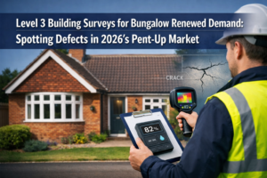
The traditional building survey report—a thick document filled with technical jargon and written descriptions—is rapidly becoming obsolete. In 2026, property buyers expect more than text-based assessments of structural defects. They want to see the problems, understand their severity through visual context, and explore properties through immersive digital experiences. Digital Tools and 3D Visualization in Building Surveys: Translating Laser Scanning and Drone Data into Client-Ready Reports represents the evolution from measurement-focused surveying to visualization-driven property assessment that transforms how clients understand and act on survey findings.
Modern surveying practices now integrate laser scanning technology, drone imagery, thermal cameras, and sophisticated visualization software to create interactive reports that communicate complex structural issues with unprecedented clarity. This technological shift doesn't just improve client satisfaction—it fundamentally repositions surveyors as essential collaborative partners throughout the property lifecycle rather than simple measurement service providers.
Key Takeaways
- 3D visualization transforms client understanding: Interactive models and visual data presentations help property buyers comprehend structural defects 300% faster than traditional text-based reports
- Cloud-based platforms enable real-time collaboration: Modern survey deliverables include browser-accessible 3D models that architects, engineers, and clients can review simultaneously from any location
- Digital tools expand surveyor value proposition: Firms delivering laser scan data, drone imagery, and BIM-integrated models position themselves as indispensable project partners rather than commodity service providers
- Mobile mapping accelerates project timelines: Advanced scanning systems capture comprehensive building data in hours instead of days, delivering detailed 3D models with millimeter-level accuracy
- Visualization identifies costly issues earlier: Interactive 3D models reveal structural conflicts, accessibility problems, and design flaws before construction begins, saving significant time and money
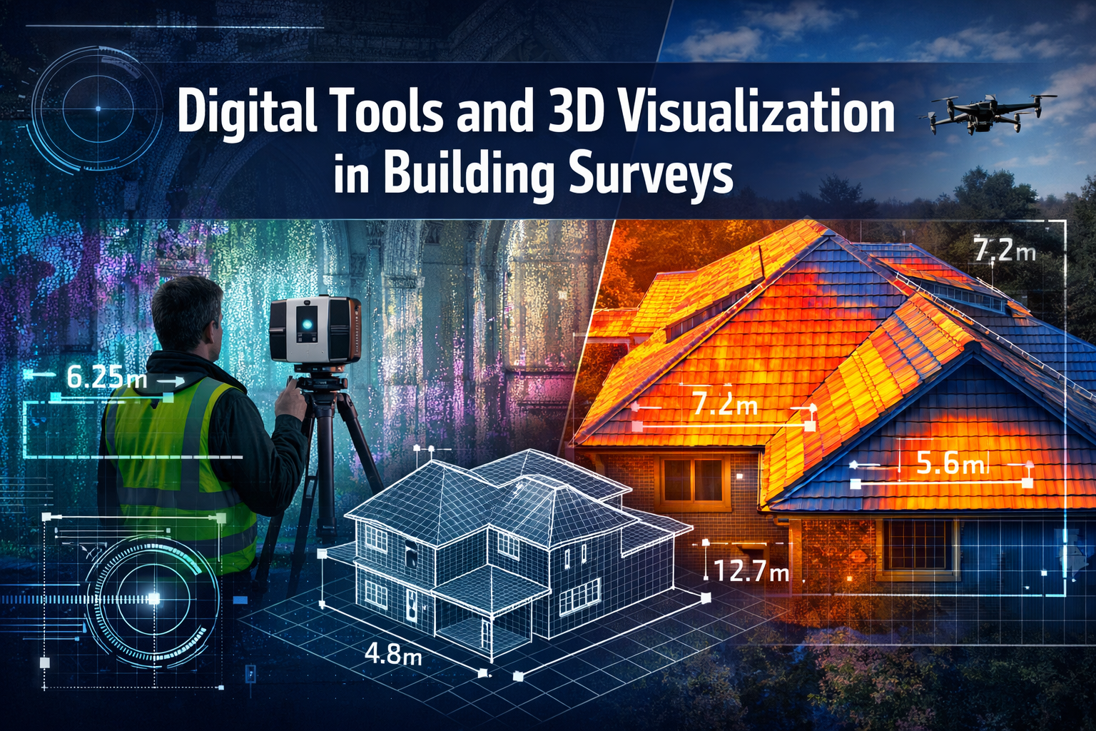
The Technology Foundation: Laser Scanning and Drone Data Capture
Modern building surveys rely on two primary data capture technologies that have become increasingly accessible and affordable in 2026: terrestrial laser scanning and unmanned aerial vehicle (UAV) photogrammetry.
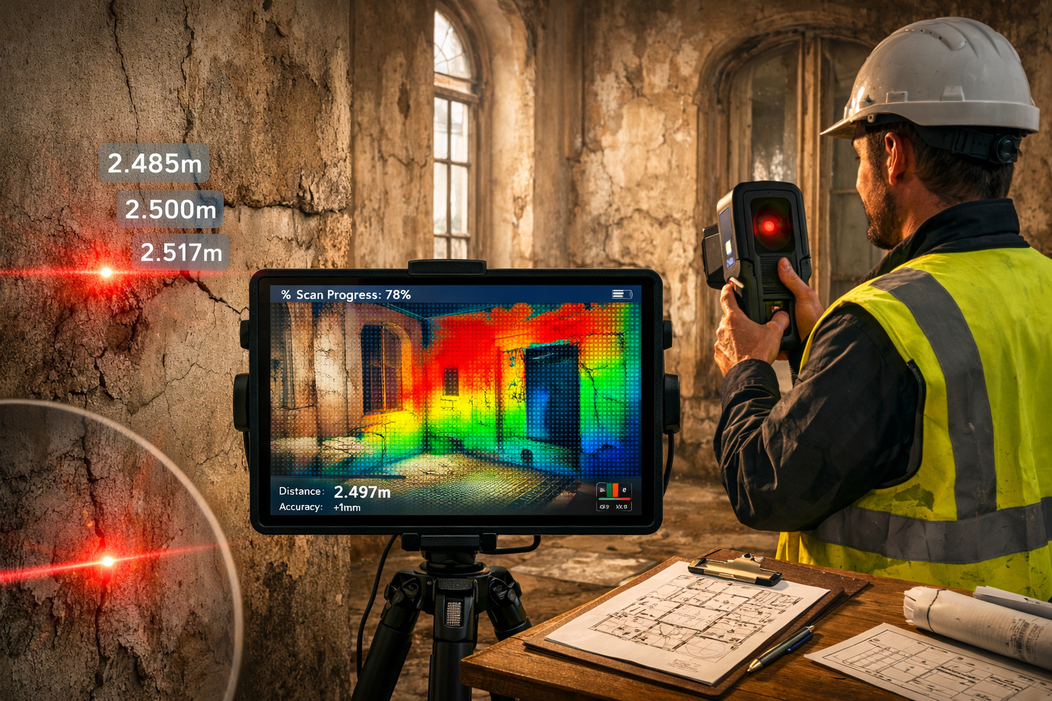
Laser Scanning: Millimeter-Precision Interior Documentation
Terrestrial laser scanners capture millions of measurement points per second, creating detailed "point clouds" that represent every surface within a building. These devices measure distances using laser pulses, recording the exact three-dimensional coordinates of walls, ceilings, floors, structural elements, and defects.
Key advantages of laser scanning technology:
- ⚡ Speed: Complete building interiors documented in 2-4 hours versus 2-3 days with traditional methods
- 🎯 Accuracy: Millimeter-level precision enables detection of subtle structural movements and deformations
- 📊 Completeness: Captures 360-degree comprehensive data, eliminating missed measurements or return visits
- 🔒 Safety: Reduces time surveyors spend in hazardous areas or unstable structures
A 2026 survey of 1,800 contractors identified scanning, surveying, and positioning as top technology priorities, with reality capture technology already invaluable for precision, safety, and speed [4]. The democratization of these tools through user-friendly interfaces and lower equipment costs has made comprehensive data collection standard practice rather than premium service.
Drone Technology: Exterior and Roof Assessment
Unmanned aerial vehicles equipped with high-resolution cameras, thermal sensors, and LiDAR systems provide unprecedented access to building exteriors, roofs, and hard-to-reach areas. Drones capture detailed imagery and measurement data without scaffolding, rope access, or cherry pickers.
Drone survey capabilities include:
| Application | Technology | Output |
|---|---|---|
| Roof condition assessment | RGB photography | High-resolution orthomosaic images with 5mm ground resolution |
| Thermal defect detection | Infrared cameras | Heat loss visualization, moisture ingress identification |
| Facade inspection | Oblique imagery | 3D textured models showing cracks, spalling, material deterioration |
| Volumetric measurement | Photogrammetry | Accurate area and volume calculations for repairs or replacements |
Mobile mapping systems now allow surveyors to create detailed 3D models from indoor and outdoor environments without bulky equipment, delivering results in significantly shorter timeframes than traditional surveying methods [2].
Integration with Traditional Survey Methods
Digital tools complement rather than replace traditional surveying expertise. Experienced surveyors interpret the data captured by technology, identifying structural significance of defects, assessing repair urgency, and providing professional judgment that automated systems cannot replicate.
The most effective structural surveys in 2026 combine:
- Digital precision: Laser measurements and drone imagery for accurate documentation
- Professional interpretation: Chartered surveyor analysis of structural implications
- Visual communication: 3D models and annotated imagery for client understanding
- Traditional validation: Physical inspection of critical areas and materials testing where necessary
Processing and Visualization: Turning Raw Data into Client Value
The true value of Digital Tools and 3D Visualization in Building Surveys: Translating Laser Scanning and Drone Data into Client-Ready Reports emerges during the processing phase, where raw point clouds and imagery transform into interactive, client-ready deliverables.
Point Cloud Processing Workflows
Raw laser scan data requires significant processing before becoming useful visualization assets. Modern workflows involve:
- Registration: Aligning multiple scan positions into a unified coordinate system
- Cleaning: Removing noise, temporary objects, and irrelevant data points
- Classification: Identifying and labeling different building elements (walls, floors, structural components)
- Mesh generation: Converting point clouds into solid 3D surfaces for visualization
- Texturing: Applying photographic imagery to create photorealistic models
Advanced software platforms automate much of this process, reducing processing time from days to hours. Cloud-based processing leverages remote computing power, enabling even small surveying firms to handle large datasets efficiently.
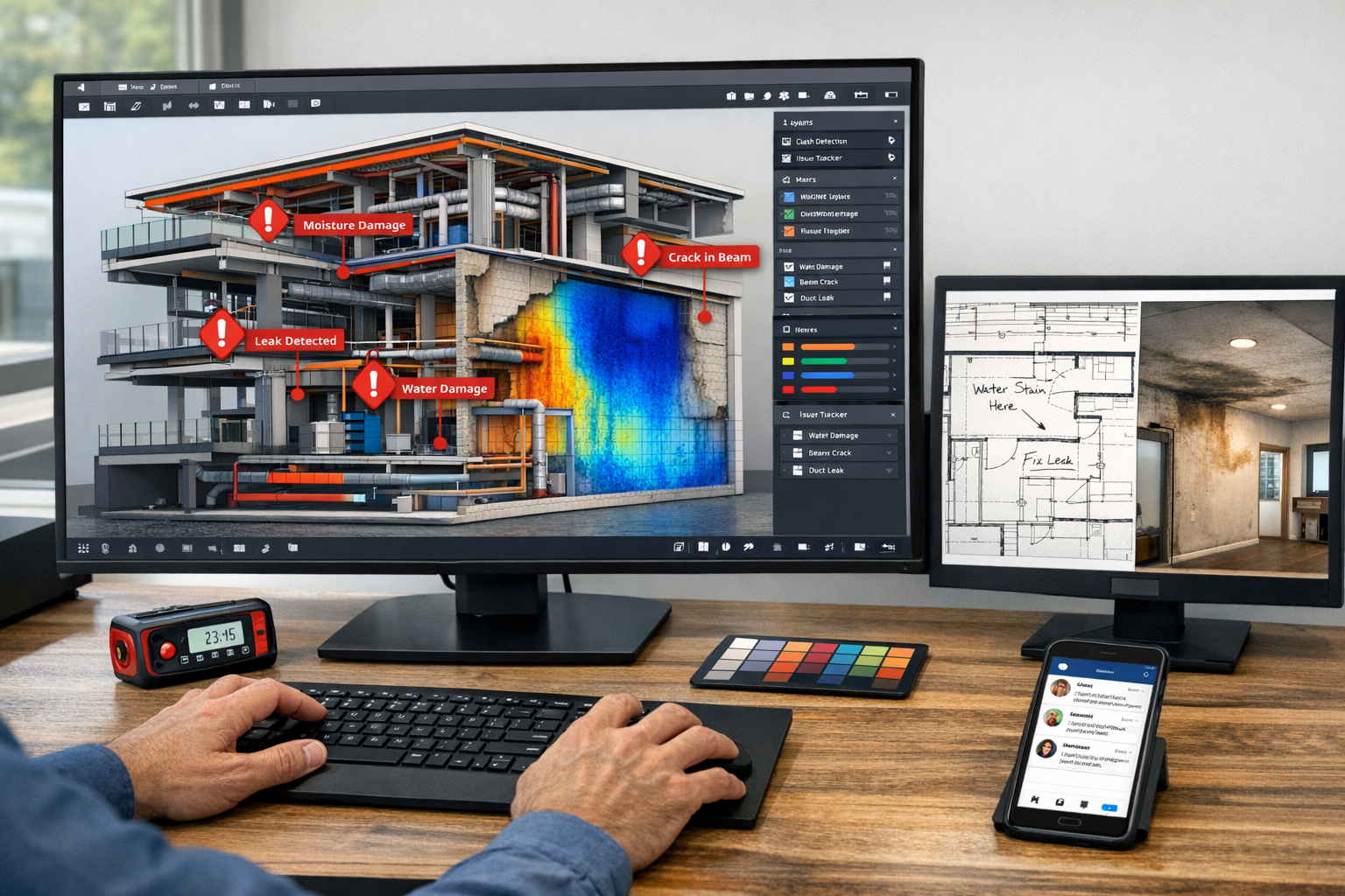
Creating Interactive 3D Models
The surveying industry has shifted from static document deliverables to interactive, cloud-based systems enabling instant file sharing, 3D visualization in browsers, real-time revision syncing, and integrated communication with engineers and architects [1]. These platforms transform survey data into engaging client experiences.
Essential features of modern 3D survey models:
- 🖱️ Navigation controls: Clients can explore buildings virtually, rotating views and zooming to areas of interest
- 📍 Defect annotations: Clickable markers link to detailed descriptions, photographs, and repair recommendations
- 📏 Measurement tools: Integrated measurement capabilities allow clients to verify dimensions and understand spatial relationships
- 🔄 Comparison modes: Side-by-side visualization of current conditions versus historical data or proposed repairs
- 📱 Multi-device access: Responsive design ensures models work on desktops, tablets, and smartphones
According to Sandra Winstead, senior director of Product, Architecture & Design at Trimble, spatial data serves as the foundation for collaboration, with discussions centralized in 3D models where designers and stakeholders can provide context, resolve questions, and make decisions in real time [3].
BIM Integration and Data Handoff
Building Information Modeling (BIM) has become the standard framework for construction project collaboration. Land surveyors increasingly integrate geospatial data into BIM systems, enhancing project planning, reducing conflicts, and improving construction project efficiency [1].
BIM-ready survey deliverables include:
- Accurate as-built models in industry-standard formats (IFC, Revit, AutoCAD)
- Georeferenced coordinate systems for site integration
- Classified building elements compatible with BIM workflows
- Embedded metadata including materials, conditions, and defect information
This integration positions surveyors as essential contributors to the entire project lifecycle rather than isolated data collectors. When conducting a RICS building survey, the digital deliverables can seamlessly feed into renovation planning, cost estimation, and construction documentation.
Thermal and Specialized Data Visualization
Beyond geometric data, modern surveys incorporate specialized imaging that reveals hidden defects:
Thermal imaging visualization shows heat loss patterns, moisture ingress, and insulation deficiencies through color-coded overlays on 3D models. This proves particularly valuable for damp surveys where moisture problems hide behind finished surfaces.
Multispectral analysis combines visible light, infrared, and ultraviolet imagery to detect material deterioration, biological growth, and structural stress invisible to standard photography.
Deformation mapping compares current laser scan data against historical measurements or design specifications, creating heat-map visualizations that highlight structural movement, settlement, or distortion with millimeter precision.
Client-Ready Report Formats and Delivery Methods
The final stage of Digital Tools and 3D Visualization in Building Surveys: Translating Laser Scanning and Drone Data into Client-Ready Reports involves packaging processed data into formats that serve diverse client needs while maintaining professional standards.
Hybrid Report Structures
Modern survey reports combine traditional written analysis with interactive digital components:
Executive summary provides high-level findings with embedded 3D model screenshots showing key defects, allowing decision-makers to grasp critical issues quickly without technical expertise.
Detailed written analysis maintains the comprehensive technical assessment expected from expert building evaluations, with hyperlinks connecting text descriptions to corresponding locations in the 3D model.
Interactive 3D viewer serves as the primary exploration tool, with defects categorized by severity (urgent, significant, minor) using color-coded annotation systems that match written report sections.
Photographic appendix includes high-resolution images embedded with metadata linking back to exact 3D model locations, providing visual evidence while maintaining spatial context.
Cloud-Based Delivery Platforms
Construction workflows now incorporate common data environments providing consistent access to documentation, context, and visualization, with project owners receiving rich datasets that inform long-term asset management strategies [3].
Modern survey delivery platforms offer:
- 🌐 Browser-based access: No specialized software required; clients view reports on any device with internet connection
- 🔐 Secure sharing: Permission-based access controls ensure confidential information reaches only authorized parties
- 💬 Integrated communication: Comment threads attached to specific defects facilitate clarification discussions
- 📊 Progress tracking: Clients can mark defects as addressed, creating audit trails for renovation projects
- 📥 Flexible downloads: Export options for 3D models, point clouds, and traditional PDF reports
This approach proves particularly valuable when clients need to share findings with contractors, architects, or lenders. Rather than forwarding static PDF files, they can provide access to the interactive platform where all stakeholders work from identical, up-to-date information.
Customized Deliverables for Different Audiences
Professional surveyors recognize that different project stakeholders require different data formats:
Property buyers need simplified visualizations emphasizing defect severity, repair costs, and negotiation leverage—essentially answering "what to do after a bad building survey report" through clear visual communication.
Architects and designers require accurate dimensional data, BIM-compatible models, and detailed material condition assessments to inform renovation designs.
Contractors and quantity surveyors need measurement-ready data for accurate cost estimation, including surface areas, volumes, and quantities derived directly from 3D models.
Property managers and facility operators benefit from comprehensive as-built documentation that supports ongoing maintenance planning and future modification projects.
Lenders and insurers require standardized reports with clear risk assessments, often preferring traditional formats supplemented with visual evidence rather than purely digital deliverables.
Augmented and Virtual Reality Applications
Augmented and Virtual Reality technologies are becoming standard for presenting ideas to clients, enabling immersive walkthroughs of 3D spaces where finishes and lighting can be adjusted on-site before construction begins [5].
VR survey applications allow clients to experience properties at full scale, walking through spaces while viewing defect annotations that appear at actual locations. This proves particularly effective for remote buyers or investors who cannot physically visit properties.
AR overlay capabilities enable on-site visualization where surveyors or contractors hold tablets or smartphones to see hidden structural elements, building services, or proposed repairs overlaid on the physical building through the device camera.
These immersive technologies remain optional enhancements rather than standard deliverables in 2026, but forward-thinking firms offer them as premium services that significantly differentiate their offerings in competitive markets.
Practical Implementation Strategies for Surveying Practices
Adopting Digital Tools and 3D Visualization in Building Surveys: Translating Laser Scanning and Drone Data into Client-Ready Reports requires strategic planning, investment, and workflow redesign. Successful implementation follows a phased approach that balances technology adoption with maintaining service quality.
Equipment Investment and Selection
The democratization of 3D mapping and visualization tools has reached higher accessibility and lower costs, enabling land surveyors to create detailed, interactive maps and models that provide clients with more immersive property understanding [1].
Entry-level implementation (£15,000-£30,000):
- Handheld laser scanner or smartphone-based LiDAR device
- Consumer-grade drone with 4K camera
- Basic point cloud processing software
- Cloud-based report delivery platform subscription
Professional implementation (£50,000-£100,000):
- Terrestrial laser scanner with millimeter accuracy
- Commercial drone with thermal and high-resolution cameras
- Comprehensive processing and BIM integration software
- Custom-branded client portal and visualization platform
Enterprise implementation (£150,000+):
- Multiple scanning systems for simultaneous deployment
- Advanced mobile mapping platforms
- Dedicated processing workstations and cloud infrastructure
- Custom software development and API integrations
Most successful firms begin with entry-level equipment for specific project types, expanding capabilities as client demand and expertise grow. This approach minimizes financial risk while building internal competency.
Training and Skill Development
Technology alone doesn't create value—skilled operators who understand both the tools and surveying principles deliver quality results.
Essential training areas include:
- Equipment operation: Safe and efficient use of scanners, drones, and specialized cameras
- Data processing: Point cloud cleaning, model generation, and quality control procedures
- Software proficiency: Mastery of visualization, BIM, and reporting platforms
- Client communication: Explaining technical findings through visual media rather than solely written descriptions
- Regulatory compliance: Understanding CAA drone regulations, data protection requirements, and professional standards
Many equipment manufacturers offer comprehensive training programs, while professional bodies like RICS provide continuing professional development courses specifically addressing digital survey methods.
Workflow Integration and Quality Control
Successful firms integrate digital tools into existing workflows rather than creating entirely separate processes. This ensures consistency, maintains quality standards, and leverages established client relationships.
Integrated workflow example:
- Pre-survey planning: Determine which technologies best suit property type and client needs
- Site visit: Conduct traditional inspection alongside digital data capture
- Data processing: Generate 3D models and visualizations while preparing written analysis
- Quality review: Verify accuracy, completeness, and clarity of both digital and traditional elements
- Client delivery: Present integrated report combining written assessment with interactive visualization
- Post-delivery support: Provide guidance on using digital tools and answer clarification questions
Quality control becomes particularly important with digital deliverables. Firms should establish verification protocols ensuring:
- ✅ Scan accuracy meets specified tolerances (typically ±5mm for building surveys)
- ✅ 3D models accurately represent captured data without processing artifacts
- ✅ Defect annotations correctly identify and describe issues
- ✅ Interactive platforms function properly across different devices and browsers
- ✅ Data security measures protect client confidential information
Marketing and Client Education
Firms delivering survey data optimized for 3D visualization and BIM integration position themselves as essential collaborative partners rather than simple measurement service vendors, expanding traditional survey deliverables [3].
Effective marketing strategies include:
- Sample interactive reports: Demonstrate capabilities through anonymized case studies clients can explore
- Before/after comparisons: Show traditional report sections alongside enhanced visualizations
- Video demonstrations: Create short tutorials showing how clients navigate and use digital deliverables
- Client testimonials: Feature feedback from buyers who found visualizations particularly helpful
- Professional differentiation: Emphasize how digital tools provide clearer understanding than competitors' text-only reports
When offering homebuyers surveys or comprehensive building inspections, clearly communicate the additional value digital visualization provides without overwhelming clients with technical jargon.
Pricing Strategy and Value Proposition
Digital survey deliverables require additional time, equipment, and expertise, justifying premium pricing compared to traditional reports. However, pricing must reflect client-perceived value rather than solely cost recovery.
Pricing approaches include:
- Tiered service levels: Offer basic (traditional report), enhanced (with 3D model), and premium (full BIM integration) options
- Project-specific pricing: Adjust based on property size, complexity, and specific visualization requirements
- Package bundling: Combine survey with monitoring services or renovation planning support
- Subscription models: Offer ongoing access to cloud platforms and data updates for property managers
Successful firms emphasize how visualization reduces client risk, accelerates decision-making, and provides long-term value beyond the initial survey. When clients understand they're receiving actionable intelligence rather than merely documentation, price sensitivity decreases significantly.
Future Trends and Emerging Capabilities
The evolution of Digital Tools and 3D Visualization in Building Surveys: Translating Laser Scanning and Drone Data into Client-Ready Reports continues accelerating as technology advances and client expectations rise.
Real-Time Digital Twins
The surveying industry is adopting real-time 3D digital twins—high-fidelity, interactive models that update continuously as new data is collected, allowing developers, engineers, and planners to visualize how land behaves under various conditions [1].
For building surveys, this means:
- Continuous monitoring: Sensors embedded during renovation track structural movement, moisture levels, and environmental conditions
- Predictive maintenance: AI algorithms analyze trends to forecast when building systems require attention
- Lifecycle documentation: Properties maintain living digital records from initial survey through ongoing modifications
- Stakeholder collaboration: All project participants work from synchronized, always-current building information
Artificial Intelligence and Automated Defect Detection
Machine learning algorithms increasingly assist surveyors by automatically identifying common defects within point cloud and imagery data:
- Crack detection: AI recognizes patterns indicating structural movement or material failure
- Moisture mapping: Algorithms analyze thermal imagery to highlight probable water ingress areas
- Material classification: Automated identification of building materials aids condition assessment
- Change detection: Comparison of historical and current scans highlights deterioration progression
These tools augment rather than replace professional judgment, flagging potential issues for surveyor review and verification.
Enhanced Visualization and Communication
Design conversations increasingly occur directly within 3D models rather than traditional 2D plans, enabling quicker iterations, faster workflows, and stronger alignment throughout design and construction phases [3].
Emerging visualization capabilities include:
- Holographic displays: 3D projections allow multiple stakeholders to view and discuss building models simultaneously without screens
- Haptic feedback: Touch-sensitive interfaces provide tactile sensation when exploring virtual building elements
- AI-generated explanations: Natural language processing creates customized defect descriptions based on client expertise level
- Automated repair visualization: Systems generate before/after comparisons showing proposed remediation work
Integration with Property Transaction Platforms
Survey data increasingly integrates with broader property technology ecosystems:
- Conveyancing platforms: Digital survey findings automatically populate legal documentation
- Mortgage systems: Lenders access standardized risk assessments directly from survey databases
- Property portals: Listings include interactive 3D models and condition reports for transparency
- Insurance platforms: Underwriters access detailed building data for accurate risk pricing
This integration streamlines property transactions while expanding surveyor touchpoints throughout the buying process.
Conclusion
Digital Tools and 3D Visualization in Building Surveys: Translating Laser Scanning and Drone Data into Client-Ready Reports represents far more than technological novelty—it fundamentally transforms how surveyors deliver value and how clients understand property condition. The shift from text-based descriptions to immersive visual experiences addresses the core challenge of making complex structural information accessible to non-technical audiences.
Advanced visualization allows professionals to spot potential issues early—including structural conflicts, awkward layouts, lighting problems, and accessibility concerns—resulting in significant time and cost savings [6]. For property buyers, this means making informed decisions with confidence rather than anxiety about hidden defects.
Surveying firms that embrace these technologies position themselves as indispensable collaborative partners throughout the property lifecycle. By delivering BIM-ready models, interactive visualizations, and cloud-accessible data platforms, they transcend the traditional role of measurement service provider to become strategic advisors whose insights inform design, construction, and long-term asset management decisions.
Actionable Next Steps
For surveying practices looking to implement digital visualization capabilities:
- Start with pilot projects: Select 5-10 suitable properties to test equipment and workflows before full-scale adoption
- Invest in training: Ensure team members understand both technology operation and effective client communication
- Develop standardized templates: Create consistent report formats that balance digital innovation with professional standards
- Gather client feedback: Systematically collect responses to refine deliverables and identify most valued features
- Build strategic partnerships: Collaborate with architects, contractors, and technology providers to expand service offerings
- Monitor industry developments: Stay informed about emerging tools, techniques, and client expectations through professional development
For property buyers and developers seeking comprehensive building assessments:
- Request sample deliverables: Review examples of 3D models and interactive reports before commissioning surveys
- Clarify data ownership: Ensure contracts specify you receive usable digital files, not just viewing access
- Consider long-term value: Evaluate how digital survey data supports renovation planning and future property management
- Engage early: Involve surveyors during due diligence to maximize value from visualization capabilities
The future of building surveys lies not in replacing professional expertise with technology, but in amplifying that expertise through visualization tools that make complex structural information universally understandable. As 3D mapping and visualization tools become more accessible and affordable, the question for surveying practices isn't whether to adopt these capabilities, but how quickly they can implement them to meet rising client expectations.
Whether you're commissioning a property condition assessment or delivering professional survey services, embracing digital tools and 3D visualization represents the clearest path to better outcomes, stronger collaboration, and more confident property decisions in 2026 and beyond.
References
[1] Future Land Surveying 2026 – https://haller-blanchard.com/future-land-surveying-2026/
[2] The Future Of Land Surveying Technology And Upcoming Trends In 2026 – https://metricop.com/blogs/land-surveying/the-future-of-land-surveying-technology-and-upcoming-trends-in-2026
[3] Doubling Down On Digital – https://amerisurv.com/2026/02/01/doubling-down-on-digital/
[4] Future Construction Technology Trends Contractor Survey – https://www.trimble.com/blog/trimble/en-US/article/future-construction-technology-trends-contractor-survey
[5] Future Architecture Trends – https://www.vectorworks.net/en-US/newsroom/future-architecture-trends
[6] Top Benefits Of 3d Architectural Visualization – https://www.gsourcedata.com/top-benefits-of-3d-architectural-visualization/