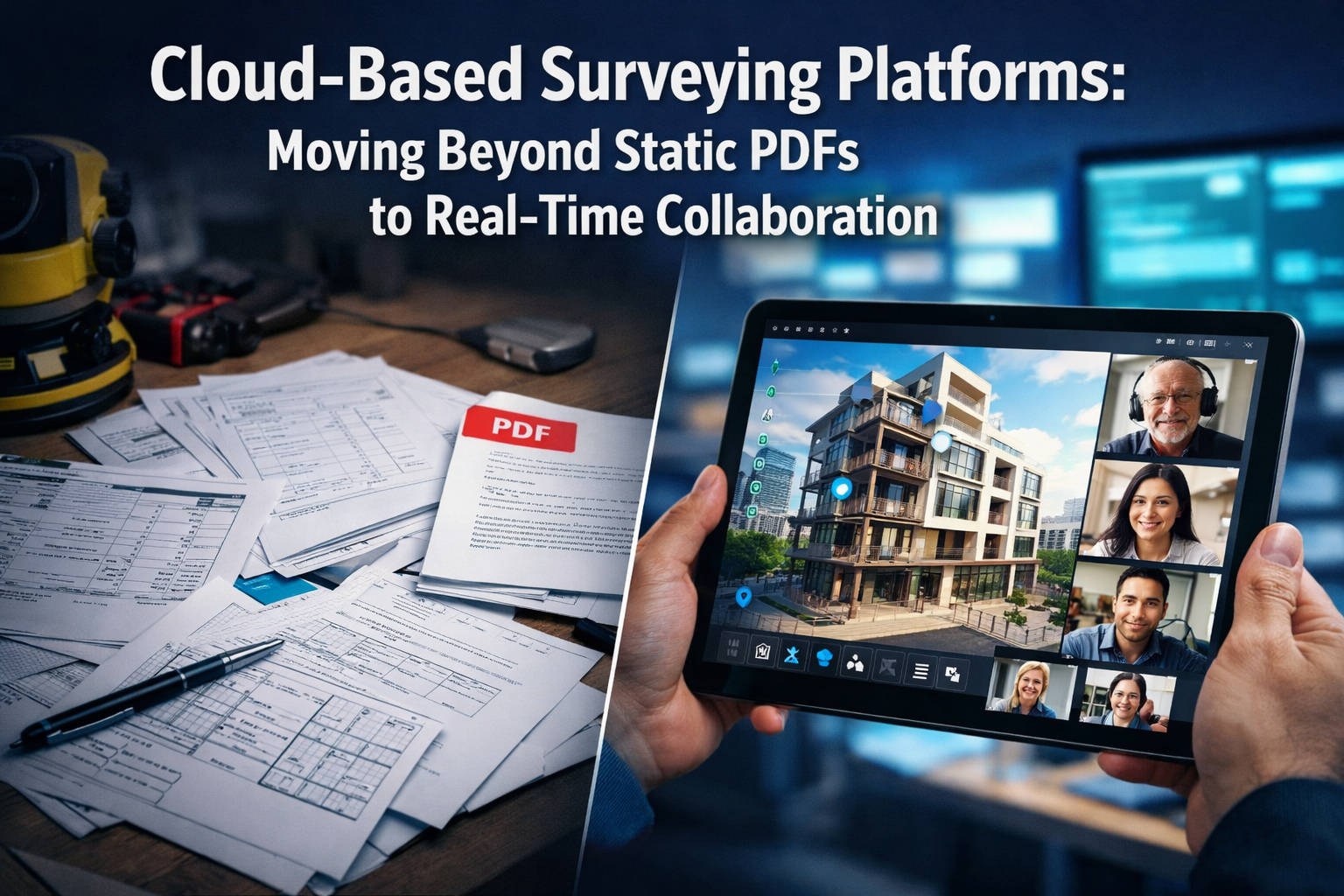
The surveying industry stands at a pivotal moment in 2026. For decades, surveyors delivered their findings as static documents—printed reports, PDF files, and 2D drawings that captured a single moment in time. These deliverables served their purpose but created significant bottlenecks in project workflows. Cloud-Based Surveying Platforms: Moving Beyond Static PDFs to Real-Time Collaboration represents a fundamental transformation in how surveying data is captured, shared, and utilized across entire project lifecycles. This shift isn't merely about technology adoption; it's about reimagining the surveyor's role from document producer to collaborative data steward.
Modern cloud platforms now enable instant file sharing, 3D visualization in browser windows, real-time revision syncing, and integrated communication between surveyors, engineers, and architects—fundamentally replacing the era of static deliverables.[1] This transformation addresses long-standing industry pain points: version control nightmares, communication delays, data silos, and the inability to make informed decisions quickly. As reality capture becomes mainstream and client expectations evolve, surveying firms face a critical choice: embrace collaborative cloud platforms or risk obsolescence in an increasingly connected construction ecosystem.
Key Takeaways
✅ Cloud platforms transform surveying deliverables from static PDFs into interactive 3D models that update continuously, enabling real-time collaboration across entire project teams.[1]
✅ Reality capture technology has evolved from specialized service to accessible mainstream toolset, enhanced by AI and machine learning for instant data processing and visualization.[2]
✅ Common Data Environments (CDEs) are becoming industry standard, allowing surveyors to contribute to dynamic shared spaces where their work informs real-time decision-making.[2]
✅ Interoperability requirements now demand seamless data flow between diverse platforms and stakeholders, raising quality standards and creating competitive differentiation opportunities.[2]
✅ Client expectations have fundamentally shifted toward rich digital deliverables with visualization-driven collaboration replacing traditional 2D plan reviews.[2]
The Limitations of Traditional Static Surveying Deliverables
The PDF Problem: Why Static Documents Create Project Bottlenecks
Traditional surveying workflows centered on producing comprehensive reports and drawings at project milestones. Surveyors would spend weeks collecting field data, processing measurements, creating detailed drawings, and compiling everything into lengthy PDF documents. These files would then be emailed to clients, architects, engineers, and contractors—each stakeholder receiving the same static snapshot of conditions.
The inherent problems with this approach include:
- Version control chaos: Multiple team members working with different versions of the same document
- Communication delays: Questions requiring clarification meant waiting for email responses or scheduling meetings
- Limited interactivity: Stakeholders couldn't explore data beyond what surveyors chose to present
- Data redundancy: Information duplicated across multiple disconnected systems
- Outdated information: By the time documents circulated, field conditions often changed
- Accessibility barriers: Large file sizes and specialized software requirements limited who could review data
For property surveyors conducting building surveys or homebuyer surveys, these limitations meant clients received comprehensive reports but couldn't interact with the underlying data or easily share findings with contractors for remediation quotes.
The Collaboration Gap in Traditional Workflows
Static deliverables created fundamental collaboration barriers. When an architect needed to verify a measurement, they couldn't simply click into the survey model—they had to contact the surveyor, wait for a response, and potentially schedule a site revisit. When engineers discovered conflicts between survey data and design intent, resolving discrepancies required multiple rounds of document exchanges and coordination meetings.
This sequential, document-based workflow extended project timelines significantly. Construction teams couldn't begin work until they received final survey documents. Design changes required completely new survey deliverables. Quality control meant manually comparing multiple static documents for consistency. The entire industry operated with built-in inefficiencies that cloud-based platforms now eliminate.
Understanding Cloud-Based Surveying Platforms and Real-Time Collaboration
What Makes a Surveying Platform "Cloud-Based"?
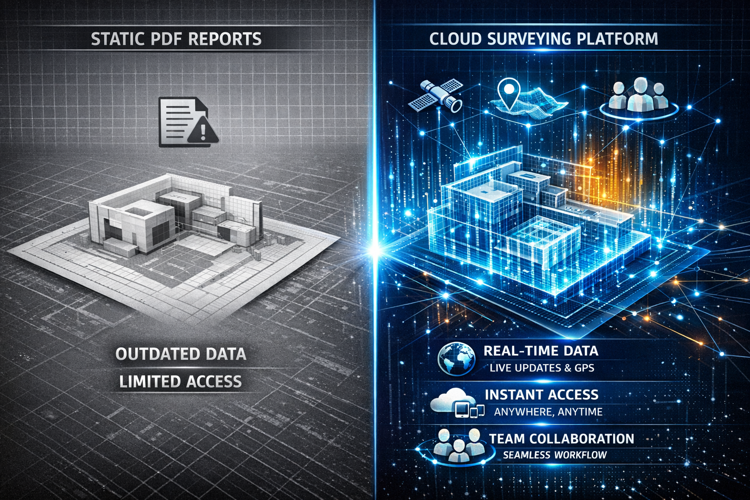
Cloud-based surveying platforms fundamentally differ from traditional desktop software by hosting data, processing capabilities, and collaboration tools on remote servers accessible via internet connection. Rather than storing survey files locally and sharing them via email or file transfer, cloud platforms create centralized repositories where all project stakeholders access the same living dataset.
Core characteristics of cloud-based surveying platforms include:
🌐 Browser-based access: View and interact with survey data without installing specialized software
☁️ Centralized data storage: Single source of truth accessible from any device, anywhere
🔄 Automatic synchronization: Changes made by any team member instantly appear for all users
👥 Multi-user collaboration: Multiple stakeholders can work simultaneously without conflicts
📱 Cross-device compatibility: Seamless experience across desktop, tablet, and smartphone
🔒 Enterprise-grade security: Encryption, access controls, and audit trails protect sensitive data
These platforms now support all major data sources—drones, LiDAR, GNSS, SLAM—in unified environments with cloud sharing options, enabling project organization by location and date for long-term or recurring work.[4] This integration capability represents a significant advancement over legacy systems that required separate software for each data type.
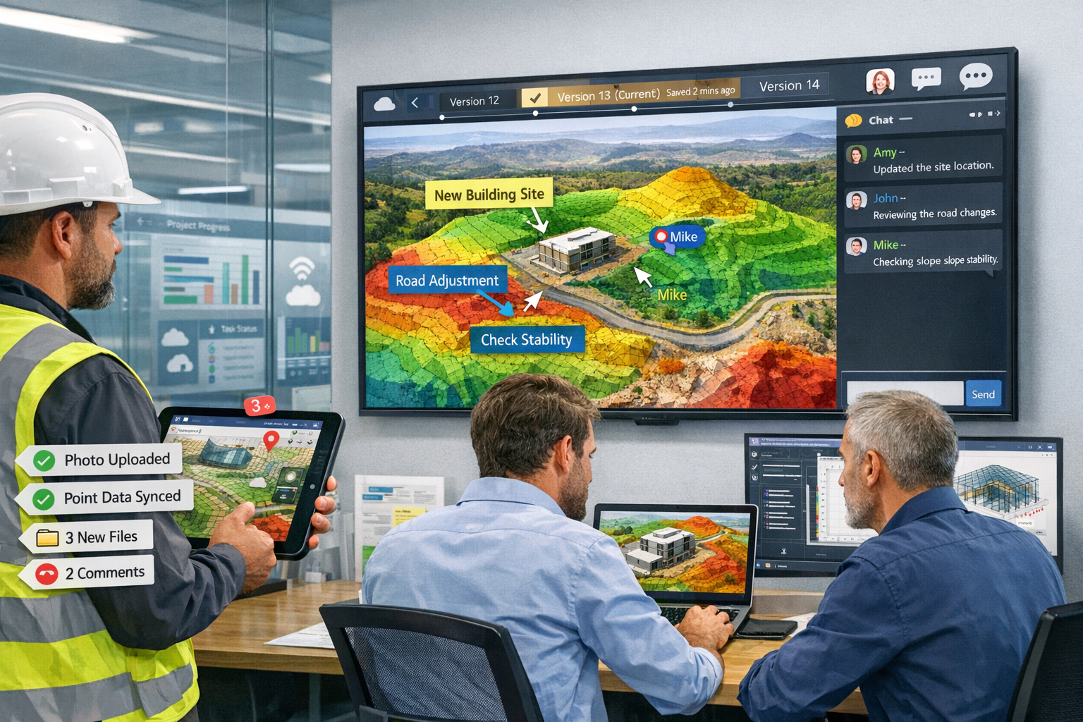
The Real-Time Collaboration Revolution
Real-time collaboration in surveying extends far beyond simple file sharing. Modern platforms enable simultaneous multi-user interaction with survey data, where architects, engineers, surveyors, and clients can all view the same 3D model, add annotations, take measurements, and communicate—all within the same interface, at the same time.
Key real-time collaboration features transforming surveying workflows:
| Feature | Traditional Approach | Cloud-Based Platform |
|---|---|---|
| Data Access | Email attachments, file transfers | Instant browser-based access |
| Version Control | Manual file naming, confusion | Automatic versioning, full history |
| Communication | Separate emails, phone calls | Integrated chat, video, annotations |
| Measurements | Request surveyor for new data | Self-service measurement tools |
| Updates | New document versions | Live data synchronization |
| Visualization | Static 2D drawings | Interactive 3D models |
This transformation particularly benefits complex projects requiring coordination between multiple disciplines. When conducting stock condition surveys across property portfolios, cloud platforms enable facilities managers to access current condition data instantly, track maintenance histories, and coordinate remediation efforts across multiple buildings simultaneously.
From Digital Twins to Interactive Deliverables
Perhaps the most significant advancement in cloud-based surveying platforms is the shift toward real-time digital twins as core deliverables. High-fidelity, interactive 3D models now update continuously as new data is collected, allowing developers and planners to visualize slope erosion projections, water flow simulations, vegetation pattern changes, and infrastructure stress testing within a single interactive model.[1]
These digital twins transcend traditional survey deliverables by providing:
- Living documentation that evolves throughout project lifecycle
- Predictive modeling capabilities for scenario planning
- Asset management integration for long-term facility operations
- Historical comparison showing changes over time
- Simulation environments for testing design alternatives
For surveyors preparing condition survey reports, digital twins enable clients to virtually walk through properties, examine defects in 3D context, and understand spatial relationships that static photographs cannot convey.
How Cloud-Based Surveying Platforms Enable Real-Time Collaboration Across Project Teams
Common Data Environments: The Foundation of Collaborative Surveying
The adoption of Common Data Environments (CDEs) is accelerating across the surveying industry as a fundamental shift in how project information is managed.[2] Rather than producing static plans or point clouds in isolation, surveyors increasingly contribute to dynamic, shared environments where their work informs real-time decision-making across construction teams.
CDEs provide a structured framework for managing all project information in a single, secure location. Every stakeholder—from surveyors to architects, engineers to contractors—accesses the same data repository, eliminating the confusion of multiple document versions and ensuring everyone works from current information.
Benefits of CDE-based surveying workflows:
✨ Single source of truth: All project data centralized in one accessible location
✨ Automated workflows: Approval processes, notifications, and task assignments streamline collaboration
✨ Audit trails: Complete history of who accessed, modified, or approved data
✨ Permission management: Granular control over who can view, edit, or share specific data
✨ Standards compliance: Built-in templates and workflows ensure regulatory adherence
When surveyors upload new topographic survey data to a CDE, architects immediately receive notifications and can begin incorporating that information into design models. Engineers can simultaneously analyze the same data for grading and drainage planning. This parallel processing dramatically reduces project timelines compared to sequential document-based workflows.
Interoperability: Breaking Down Data Silos
Modern projects require data sharing across diverse teams and technology platforms. Interoperability as a competitive necessity has emerged as a critical trend in 2026, with improved data exchange capabilities reducing friction in handoffs and ensuring spatial information flows seamlessly between systems.[2]
Cloud-based surveying platforms achieve interoperability through:
- Open file format support: Industry-standard formats (IFC, LandXML, DWG, RCP) ensure compatibility
- API integrations: Direct connections to BIM software, project management tools, and design platforms
- Data translation engines: Automatic conversion between different coordinate systems and formats
- Standardized metadata: Consistent information tagging enables cross-platform searching and filtering
This interoperability allows surveyors to deliver data that integrates directly into architects' Revit models, engineers' Civil 3D projects, and contractors' construction management systems—without manual reformatting or data loss. When preparing RICS building surveys, surveyors can now provide deliverables that clients' preferred consultants can immediately utilize without compatibility issues.
Visualization-Driven Collaboration: Working in 3D
Design conversations increasingly take place directly within 3D models rather than on traditional 2D plans, enabling quicker iterations and stronger alignment throughout design and construction phases.[2] This visualization-driven collaboration represents a fundamental shift in how project teams communicate and make decisions.
Cloud-based platforms enable:
📊 Immersive 3D visualization: Stakeholders explore survey data as interactive point clouds or mesh models
📊 Markup and annotation tools: Team members add comments, questions, and suggestions directly on 3D models
📊 Measurement capabilities: Anyone can take measurements without specialized surveying knowledge
📊 Section cutting: Dynamic cross-sections reveal internal conditions and spatial relationships
📊 Comparison views: Side-by-side or overlay comparisons show design versus as-built conditions
This visual approach makes technical survey data accessible to non-technical stakeholders. Property owners can understand structural issues identified in surveys by virtually exploring defects in 3D context. Contractors can visualize site conditions before mobilization, reducing surprises and change orders.
For firms offering structural survey services, 3D visualization helps clients comprehend complex structural deficiencies and understand recommended remediation approaches more effectively than traditional written descriptions.
Key Technologies Powering Cloud-Based Surveying Platforms in 2026
AI-Powered Data Processing and Analysis
Artificial intelligence has transformed surveying workflows from labor-intensive manual processes to highly automated operations. Instead of manually sorting through raw field data, AI systems now instantly classify terrain, identify markers, flag anomalies, and generate preliminary surface models—freeing surveyors to spend more time applying expertise rather than processing data.[1]
AI capabilities revolutionizing surveying include:
🤖 Automatic feature extraction: AI identifies buildings, roads, vegetation, and utilities from point clouds
🤖 Defect detection: Machine learning algorithms spot cracks, deformation, and deterioration patterns
🤖 Quality control: Automated checks identify data gaps, outliers, and inconsistencies
🤖 Predictive analytics: Historical data analysis forecasts maintenance needs and structural risks
🤖 Natural language reporting: AI generates preliminary survey descriptions from 3D data
These AI capabilities dramatically reduce the time between field data collection and deliverable production. What once required days or weeks of manual processing now happens in hours, enabling truly real-time collaboration where stakeholders can access and analyze survey data almost immediately after collection.
Reality Capture: From Specialized Service to Mainstream Tool
Reality capture evolved from a specialized service to an increasingly accessible toolset that firms of all sizes can deploy in 2026.[2] Enhanced by AI, machine learning, and cloud-based platforms, surveyors can now document conditions, visually track progress, and collaborate on solutions in real time.
Modern reality capture encompasses multiple technologies:
- Terrestrial laser scanning: High-precision 3D documentation of buildings and infrastructure
- Aerial photogrammetry: Drone-based imaging for site mapping and monitoring
- Mobile mapping: Vehicle or backpack-mounted systems for rapid corridor surveys
- 360-degree photography: Immersive visual documentation linked to spatial data
Cloud platforms integrate all these data sources into unified environments where stakeholders can navigate between different capture methods seamlessly. A project team might review aerial drone imagery to understand site context, then zoom into terrestrial laser scan data for detailed building measurements, then view 360-degree photos to see visual conditions—all within the same platform interface.
This integration proves particularly valuable for dilapidations surveys, where landlords and tenants need comprehensive documentation of property conditions at lease commencement and termination.
Building Information Modeling (BIM) Integration
Land surveyors are increasingly collaborating with architects, engineers, and construction professionals to integrate geospatial data into BIM models, enhancing project planning and reducing conflicts.[1] This BIM integration represents a fundamental shift in surveying's role within the construction ecosystem.
Cloud-based platforms facilitate BIM integration through:
- Direct model imports: Survey data loads directly into Revit, ArchiCAD, and other BIM platforms
- Clash detection: Automated identification of conflicts between existing conditions and design intent
- As-built verification: Continuous comparison of construction progress against design models
- Federated models: Survey data combines with architectural, structural, and MEP models in unified environments
This integration ensures survey data remains accessible and useful throughout entire project lifecycles. When conducting Level 2 or Level 3 surveys, surveyors can now deliver BIM-compatible data that architects immediately incorporate into renovation or extension designs.
Mobile and Remote Surveying Capabilities
COVID-19 accelerated remote surveying adoption, allowing surveyors to conduct assessments and data collection with reduced on-site visits, addressing safety concerns and increasing efficiency.[1] This trend has continued evolving in 2026, with cloud platforms enabling sophisticated remote collaboration workflows.
Remote surveying capabilities include:
📱 Mobile data collection apps: Field surveyors capture data directly into cloud platforms via smartphones and tablets
📱 Remote desktop access: Office-based team members process and analyze data while field crews continue collecting
📱 Live streaming: Real-time video feeds allow remote experts to guide on-site personnel
📱 Automated upload: Field data automatically syncs to cloud platforms when devices connect to networks
📱 Offline functionality: Mobile apps work without connectivity, syncing when networks become available
These capabilities enable distributed teams to collaborate effectively regardless of location. Senior surveyors can oversee multiple projects simultaneously, providing expertise remotely rather than traveling between sites. Clients can participate in virtual site visits, viewing conditions through surveyors' mobile devices in real time.
Practical Benefits: How Cloud-Based Surveying Platforms Improve Project Outcomes
Accelerated Project Timelines Through Parallel Workflows
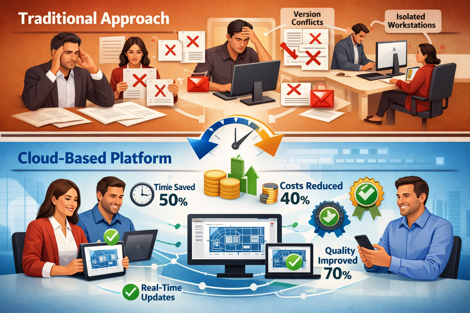
Traditional sequential surveying workflows created significant project delays. Teams waited for survey completion before beginning design work, then waited for design completion before starting construction planning. Cloud-based platforms enable parallel workflows where multiple disciplines work simultaneously with continuously updated survey data.
Timeline improvements include:
⏱️ Immediate data access: Stakeholders review survey data as it's collected, not weeks later
⏱️ Concurrent design: Architects begin preliminary designs while surveyors complete detailed mapping
⏱️ Rapid iteration: Design changes incorporate updated survey data within hours, not days
⏱️ Reduced coordination meetings: Real-time collaboration replaces lengthy coordination sessions
⏱️ Faster approvals: Stakeholders review and approve deliverables within cloud platforms
Projects that previously required 12-18 months from survey to construction start now compress to 8-12 months through these efficiency gains. For property transactions requiring homebuyer surveys, faster turnaround times help buyers meet tight closing deadlines and avoid transaction delays.
Enhanced Decision-Making Through Data Accessibility
Cloud platforms democratize access to survey data, enabling informed decision-making across entire project teams rather than limiting technical data to specialized professionals. Non-technical stakeholders can explore 3D models, take measurements, and understand spatial relationships without surveying expertise.
This accessibility transforms decision-making by:
- Reducing assumptions: Stakeholders verify conditions directly rather than relying on secondhand descriptions
- Enabling scenario testing: Teams evaluate multiple design alternatives against actual site conditions
- Improving communication: Visual 3D data conveys complex information more effectively than technical drawings
- Accelerating approvals: Decision-makers understand proposals more quickly with interactive visualization
Property owners reviewing condition survey reports can now explore defects in 3D context, understand severity through visual documentation, and make informed decisions about remediation priorities and budgets.
Cost Savings Through Reduced Rework and Conflicts
Rework represents one of construction's largest cost drivers, often resulting from conflicts between existing conditions and design intent. Cloud-based surveying platforms dramatically reduce these conflicts by ensuring all stakeholders work from accurate, current site data.
Cost savings mechanisms include:
💰 Early conflict detection: Automated clash detection identifies issues during design, not construction
💰 Accurate quantity takeoffs: Precise measurements reduce material overages and shortages
💰 Reduced site visits: Comprehensive digital documentation minimizes return trips for additional measurements
💰 Fewer change orders: Accurate as-built data prevents surprises during construction
💰 Optimized resource allocation: Real-time progress tracking enables just-in-time material and labor scheduling
Industry studies suggest cloud-based collaboration platforms reduce overall project costs by 8-15% through these combined efficiencies. For large infrastructure projects, these savings can reach millions of pounds.
Improved Quality Control and Documentation
Cloud platforms provide unprecedented quality control capabilities through comprehensive audit trails, version control, and automated validation. Every data modification, measurement, and decision is documented with timestamps and user attribution, creating complete project histories.
Quality improvements include:
✓ Automated validation: Systems flag incomplete data, measurement errors, and inconsistencies
✓ Peer review workflows: Built-in approval processes ensure multiple professionals verify critical data
✓ Standards compliance: Templates and checklists ensure deliverables meet regulatory requirements
✓ Historical comparison: Time-series data reveals changes and validates construction progress
✓ Comprehensive documentation: Complete project records support warranty claims and dispute resolution
For surveyors conducting monitoring surveys to track structural movement or settlement, cloud platforms enable automated comparison between survey epochs, instantly highlighting changes that exceed tolerance thresholds.
Overcoming Implementation Challenges: Transitioning to Cloud-Based Surveying
Addressing Data Security and Privacy Concerns
Organizations often hesitate to adopt cloud platforms due to data security concerns. Legitimate questions arise about who can access sensitive survey data, how information is protected during transmission and storage, and whether cloud platforms comply with industry regulations.
Modern cloud surveying platforms address these concerns through:
🔐 End-to-end encryption: Data encrypted during transmission and at rest on servers
🔐 Multi-factor authentication: Additional security layers beyond simple passwords
🔐 Granular access controls: Precise permissions determine who can view, edit, or share specific data
🔐 Compliance certifications: SOC 2, ISO 27001, and industry-specific security standards
🔐 Data residency options: Geographic controls ensure data remains in specific jurisdictions
🔐 Regular security audits: Independent verification of security measures and vulnerability testing
Leading cloud platforms often provide superior security compared to traditional on-premises systems, as they employ dedicated security teams and infrastructure that individual surveying firms cannot economically maintain. However, organizations must still conduct due diligence, reviewing platform security documentation and ensuring alignment with their specific requirements.
Managing the Cultural Shift to Collaborative Workflows
Technology implementation represents only part of the cloud platform transition challenge. Cultural and workflow changes often prove more difficult than technical integration. Surveyors accustomed to controlling deliverables may resist opening work-in-progress data to client access. Team members comfortable with familiar desktop software may hesitate to learn new cloud-based interfaces.
Successful transitions require:
👥 Executive sponsorship: Leadership commitment to collaborative workflows and platform adoption
👥 Phased implementation: Gradual rollout starting with pilot projects before full deployment
👥 Comprehensive training: Hands-on instruction covering both technical skills and collaborative workflows
👥 Change champions: Enthusiastic early adopters who demonstrate benefits and support colleagues
👥 Clear communication: Transparent explanation of why changes are necessary and how they benefit everyone
👥 Feedback mechanisms: Channels for team members to voice concerns and suggest improvements
Organizations should anticipate 6-12 months for full cultural adoption, even when technical implementation completes more quickly. Patience and consistent reinforcement of collaborative principles prove essential for long-term success.
Integration with Existing Systems and Workflows
Most surveying firms operate with established technology ecosystems including desktop surveying software, accounting systems, project management tools, and client relationship management platforms. Cloud platform adoption must account for integration with these existing systems rather than requiring complete replacement.
Integration strategies include:
🔗 API connections: Direct data exchange between cloud platforms and existing software
🔗 File format compatibility: Support for importing and exporting standard industry formats
🔗 Hybrid workflows: Cloud platforms for collaboration, desktop software for specialized processing
🔗 Data migration planning: Systematic transfer of historical project data to cloud repositories
🔗 Vendor partnerships: Collaboration between software providers to ensure interoperability
Firms should prioritize platforms offering robust integration capabilities and avoid solutions requiring complete technology stack replacement. Gradual evolution proves more practical than revolutionary change for most organizations.
Training and Skill Development Requirements
Cloud-based surveying platforms require different skill sets than traditional desktop software. While technical surveying expertise remains essential, additional competencies become necessary for effective platform utilization.
Key skill development areas:
📚 Cloud platform navigation: Understanding interface layouts, data organization, and feature locations
📚 Collaborative workflows: Learning to work with real-time data sharing and multi-user environments
📚 3D visualization tools: Mastering interactive model navigation, measurement, and annotation
📚 Data management: Organizing projects, managing permissions, and maintaining data quality
📚 Communication skills: Effectively using integrated chat, video, and markup tools
Training programs should combine formal instruction, hands-on practice with real project data, and ongoing support as team members encounter new scenarios. Many platform vendors offer certification programs that validate proficiency and provide structured learning paths.
The Future of Cloud-Based Surveying: Trends Shaping 2026 and Beyond
Augmented Reality Integration for Field and Office Workflows
Augmented reality (AR) represents the next frontier in surveying visualization, overlaying digital survey data onto real-world views through smartphones, tablets, or specialized glasses. Field surveyors can visualize underground utilities before excavation, see design intent superimposed on existing conditions, and capture measurements with gesture-based interfaces.
Cloud platforms increasingly incorporate AR capabilities:
- On-site visualization: View proposed designs overlaid on actual site conditions
- Utility mapping: Display subsurface infrastructure locations during excavation planning
- Quality verification: Compare as-built construction against design models in real time
- Remote assistance: Enable off-site experts to see what field personnel see and provide guidance
As AR hardware becomes more affordable and capable, these workflows will transition from experimental to standard practice, further enhancing real-time collaboration between field and office teams.
Advanced Analytics and Predictive Modeling
Cloud platforms accumulate vast datasets across multiple projects, creating opportunities for advanced analytics and machine learning that individual projects cannot support. By analyzing patterns across thousands of surveys, AI systems can predict likely defects, estimate remediation costs, and forecast maintenance requirements with increasing accuracy.
Emerging analytical capabilities include:
📊 Defect prediction: Historical data identifies properties likely to develop specific issues
📊 Cost estimation: Automated quantity takeoffs and historical pricing generate accurate budgets
📊 Risk assessment: Pattern recognition flags high-risk conditions requiring additional investigation
📊 Performance benchmarking: Compare project metrics against industry standards and best practices
These capabilities transform surveying from purely descriptive documentation to predictive intelligence, providing clients with actionable insights rather than raw data alone.
Increased Automation and Autonomous Data Collection
Automation continues advancing across surveying workflows, from autonomous drones conducting site mapping without pilot intervention to robotic total stations tracking construction progress automatically. Cloud platforms orchestrate these automated systems, processing incoming data streams and alerting human experts when conditions require attention.
Future automation trends include:
- Continuous monitoring: Permanent sensors providing real-time structural health data
- Automated progress tracking: Daily drone flights documenting construction advancement
- Self-service measurements: Clients extracting measurements directly from cloud-hosted models
- Intelligent scheduling: AI systems determining optimal survey timing based on project needs
This automation doesn't eliminate surveying professionals but rather elevates their roles from data collectors to data interpreters and strategic advisors.
Expanding Client Expectations and Service Differentiation
As cloud-based platforms become industry standard, client expectations continue evolving. Stakeholders increasingly expect rich digital deliverables rather than traditional survey products alone, creating differentiation opportunities for surveying firms that weave reality capture into core service offerings.[2]
Forward-thinking firms differentiate through:
🌟 Value-added services: Offering ongoing data hosting, visualization, and analytics beyond initial surveys
🌟 Specialized expertise: Developing deep knowledge in specific building types or defect categories
🌟 Technology leadership: Early adoption of emerging tools providing competitive advantages
🌟 Collaborative partnerships: Building long-term relationships through superior collaboration experiences
🌟 Comprehensive solutions: Bundling surveying with related services like monitoring and asset management
Firms that view cloud platforms merely as delivery mechanisms miss opportunities to fundamentally reimagine service offerings and client relationships. The most successful organizations embrace platforms as enablers of entirely new business models centered on continuous data services rather than one-time deliverables.
Conclusion: Embracing the Collaborative Future of Surveying
Cloud-Based Surveying Platforms: Moving Beyond Static PDFs to Real-Time Collaboration represents far more than a technological upgrade—it embodies a fundamental transformation in how surveying professionals create value for clients and collaborate with project teams. The shift from static deliverables to interactive, continuously updated digital twins addresses long-standing industry inefficiencies while opening new possibilities for data-driven decision-making throughout project lifecycles.
The evidence is compelling: reality capture has moved mainstream, common data environments are becoming standard practice, interoperability requirements are rising, and client expectations have fundamentally shifted toward rich digital deliverables with visualization-driven collaboration.[2] Surveying firms that embrace these changes position themselves as essential collaborative partners in increasingly complex construction ecosystems. Those clinging to traditional static deliverables risk marginalization as clients and project teams demand real-time access to interactive spatial data.
Actionable Next Steps for Surveying Professionals
Organizations ready to embrace cloud-based surveying platforms should consider these concrete actions:
1. Assess Current State and Define Objectives
- Evaluate existing workflows identifying collaboration pain points and inefficiencies
- Define specific goals for platform adoption (timeline reduction, cost savings, client satisfaction)
- Survey team members and clients about desired capabilities and concerns
2. Research and Select Appropriate Platforms
- Investigate platforms supporting your specific surveying disciplines and data types
- Verify integration capabilities with existing software and client systems
- Request demonstrations and trial periods to evaluate user experience
- Review security certifications and compliance with relevant regulations
3. Develop Implementation Roadmap
- Start with pilot project to test workflows and identify challenges
- Create phased rollout plan expanding platform use gradually
- Establish training programs covering technical skills and collaborative workflows
- Define success metrics and monitoring processes
4. Invest in Team Development
- Provide comprehensive training on platform capabilities and best practices
- Identify and empower change champions who will support colleagues
- Create opportunities for team members to share experiences and solutions
- Recognize and reward successful adoption and innovative platform uses
5. Communicate Value to Clients
- Develop marketing materials explaining collaborative workflow benefits
- Offer platform demonstrations showing interactive deliverable capabilities
- Create case studies documenting project improvements from platform adoption
- Educate clients on how they can maximize value from digital deliverables
6. Continuously Improve and Evolve
- Gather regular feedback from team members and clients
- Monitor platform vendor roadmaps for new capabilities and features
- Stay informed about industry trends and emerging technologies
- Regularly reassess workflows optimizing platform utilization
The transition to cloud-based surveying platforms requires investment, patience, and commitment. However, the benefits—accelerated timelines, enhanced collaboration, improved quality, and competitive differentiation—far outweigh the challenges. As the construction industry continues its digital transformation, surveyors who embrace real-time collaborative platforms will thrive as essential data stewards and strategic advisors.
The era of static PDFs is ending. The future belongs to dynamic, interactive, continuously updated digital environments where surveyors, designers, builders, and owners collaborate seamlessly to create better built environments. The question isn't whether to adopt cloud-based surveying platforms, but how quickly organizations can successfully transition to these collaborative workflows.
For surveying professionals seeking guidance on implementing modern surveying approaches, understanding what to do before a survey or finding the best local surveyor who embraces collaborative technologies, the path forward is clear: embrace the cloud, prioritize collaboration, and deliver value through interactive data rather than static documents.
References
[1] Future Land Surveying 2026 – https://haller-blanchard.com/future-land-surveying-2026/
[2] Doubling Down On Digital – https://amerisurv.com/2026/02/01/doubling-down-on-digital/
[3] Cloud Collaboration Platform – https://www.aecplustech.com/tools/category/cloud-collaboration-platform
[4] 3dsurvey Is The Best Photogrammetry Software In 2026 – https://3dsurvey.si/3dsurvey-is-the-best-photogrammetry-software-in-2026/
[5] The 10 Best Cloud Management Platforms In 2026 – https://holori.com/the-10-best-cloud-management-platforms-in-2026/
[6] Cloud Based Surveying Platforms Why Real Time Collaboration Is Becoming Industry Standard 2 – https://nottinghillsurveyors.com/blog/cloud-based-surveying-platforms-why-real-time-collaboration-is-becoming-industry-standard-2
[7] Ai Driven Precision In Property Surveying How Artificial Intelligence Is Revolutionizing Workflows In 2026 – https://nottinghillsurveyors.com/blog/ai-driven-precision-in-property-surveying-how-artificial-intelligence-is-revolutionizing-workflows-in-2026