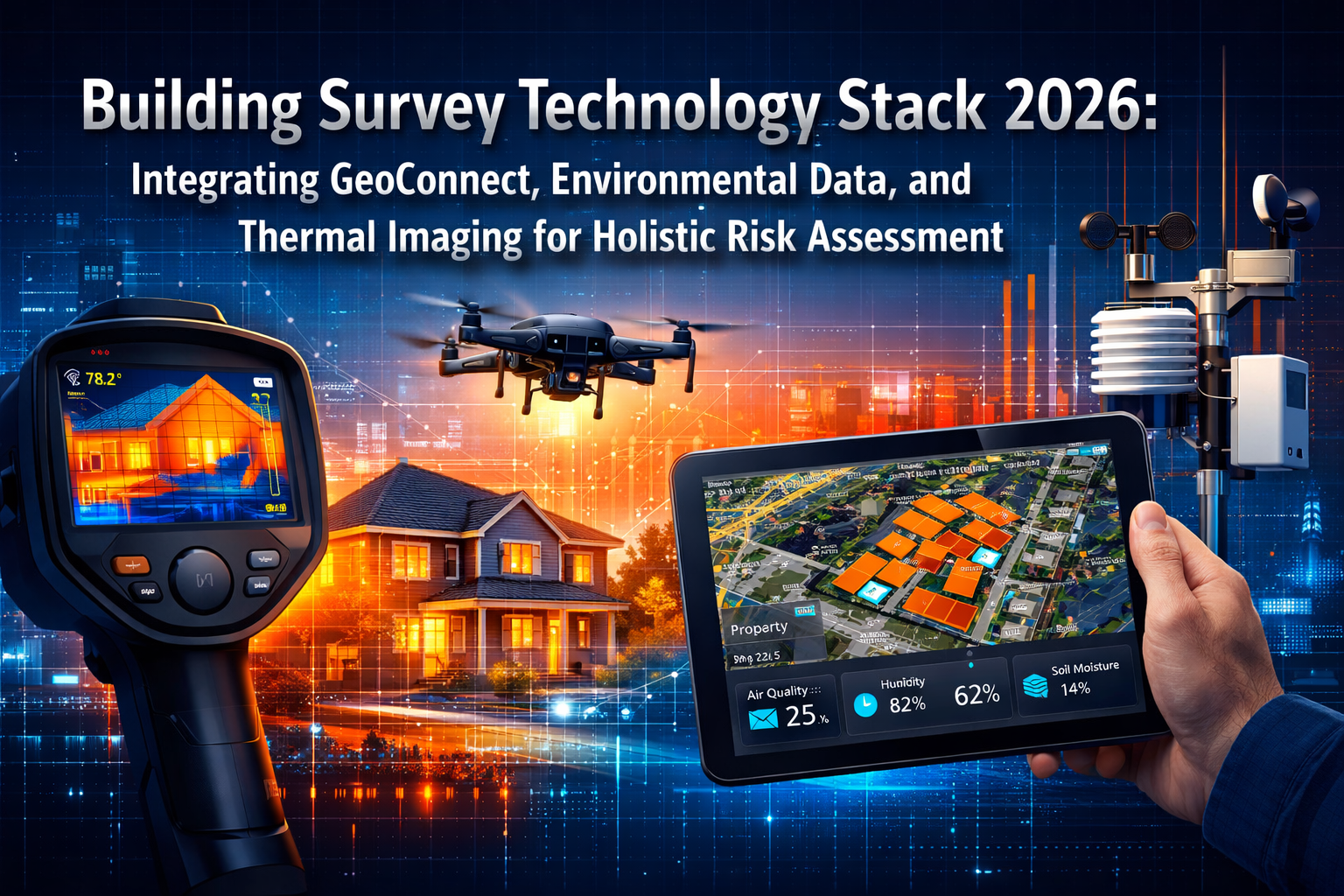
A recent industry analysis reveals that organizations deploying integrated geospatial technology stacks have reduced infrastructure failure incidents by up to 40% compared to traditional assessment methods. This dramatic shift reflects a fundamental transformation in how building surveyors approach property risk assessment in 2026. The Building Survey Technology Stack 2026: Integrating GeoConnect, Environmental Data, and Thermal Imaging for Holistic Risk Assessment represents more than incremental improvement—it marks a paradigm shift from reactive valuation to proactive risk identification that empowers property professionals to make informed decisions before problems escalate.
The modern surveying landscape demands comprehensive data integration across multiple technology platforms. Where traditional surveys relied on visual inspection and experience alone, today's professionals leverage GeoConnect spatial mapping, thermal imaging diagnostics, and environmental sensor networks to build complete risk profiles. This integrated approach transforms how surveyors identify structural defects, predict maintenance needs, and assess long-term property viability.

Key Takeaways
- Integrated technology stacks combining GeoConnect, thermal imaging, and environmental sensors provide 360-degree property risk visibility that traditional methods cannot match
- AI-powered predictive analytics now identify emerging maintenance issues and structural failures before they become critical, reducing costs by 30-40%
- Multi-sensor fusion enables millimeter-level precision in spatial data capture while simultaneously revealing hidden defects through thermal and environmental analysis
- Digital twins and 3D modeling have transitioned from theoretical concepts to operational assets that support long-term asset management and compliance reporting
- Professional judgment remains central—technology enhances rather than replaces the expertise of qualified building surveyors in interpreting complex risk scenarios
Understanding the Building Survey Technology Stack 2026: Core Components and Integration Principles
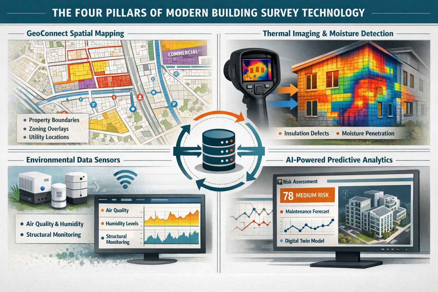
The Building Survey Technology Stack 2026: Integrating GeoConnect, Environmental Data, and Thermal Imaging for Holistic Risk Assessment consists of four interconnected technology layers that work together to provide comprehensive property intelligence. Each component contributes unique data streams that, when integrated, reveal risk factors invisible to single-technology approaches.
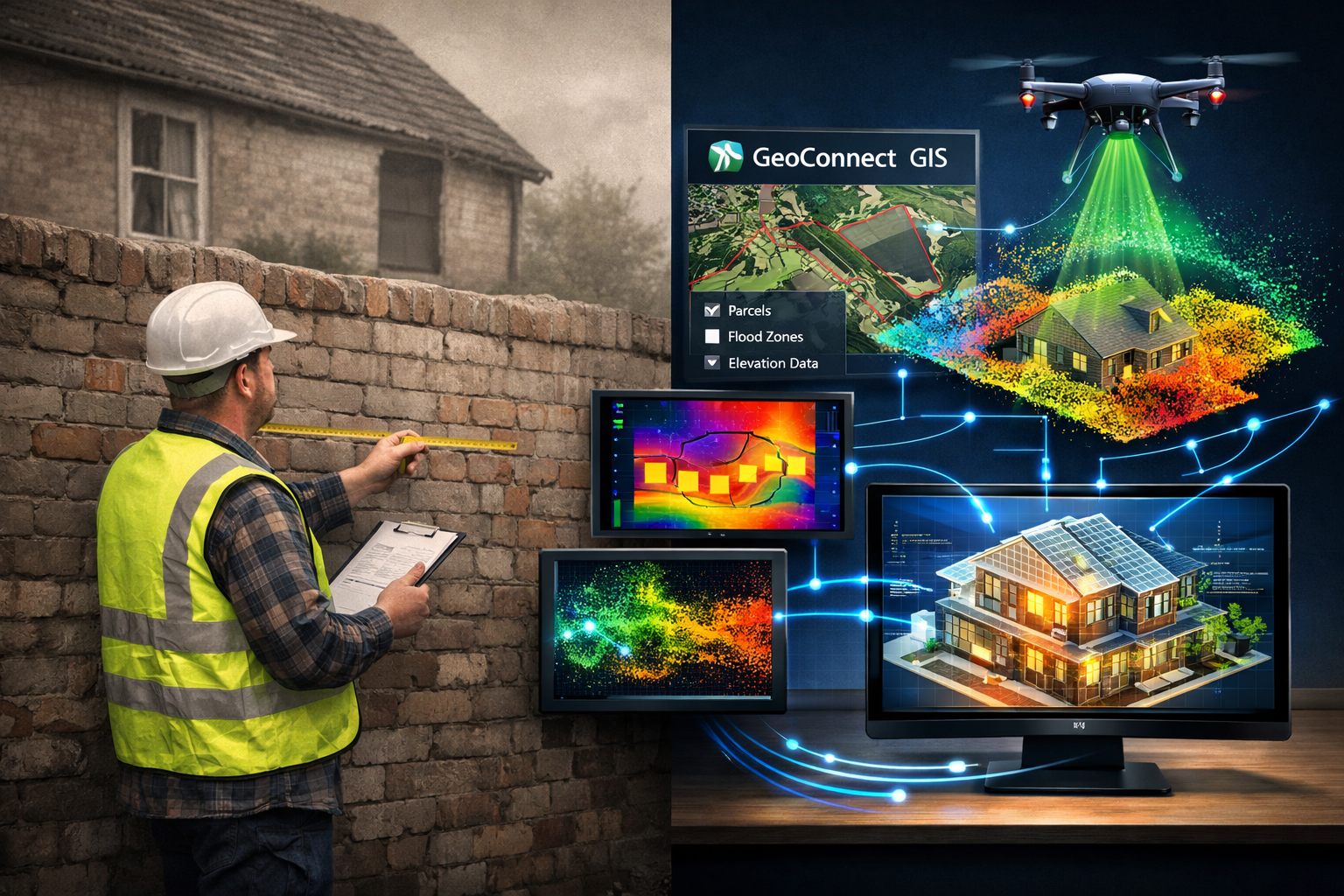
GeoConnect and Spatial Intelligence Foundations
GeoConnect and Geographic Information Systems (GIS) form the spatial backbone of modern building surveys. These platforms enable surveyors to overlay multiple datasets—including property boundaries, zoning regulations, utility locations, flood risk zones, and historical land use—into unified digital maps [5]. This spatial context transforms isolated observations into comprehensive risk narratives.
The integration of GeoAI and machine learning into geospatial workflows has moved beyond experimental status to operational implementation across utilities and infrastructure sectors [2]. Surveyors can now access AI-enhanced feature extraction that automatically identifies property characteristics, predict asset conditions based on spatial patterns, and generate automated map products that highlight risk concentrations.
Key GeoConnect capabilities include:
- 📍 Property boundary verification with centimeter-level accuracy using GNSS and sensor fusion technology
- 🗺️ Multi-layer spatial analysis combining environmental, regulatory, and infrastructure datasets
- 🔍 Historical change detection revealing property alterations, subsidence patterns, and neighborhood evolution
- ⚠️ Proximity risk assessment identifying nearby hazards such as flood zones, contaminated sites, or infrastructure vulnerabilities
When conducting a RICS building survey, professionals now routinely incorporate GeoConnect data to contextualize findings within broader spatial risk frameworks. This geographic intelligence proves particularly valuable when choosing the right property assessment approach for properties in complex urban environments or areas with known environmental challenges.
Thermal Imaging: Revealing Hidden Structural and Environmental Defects
Thermal imaging technology has emerged as a critical diagnostic component of building surveys, revealing heat loss patterns, moisture intrusion, and structural anomalies that remain invisible to visual inspection [1]. Modern thermal cameras capture infrared radiation across building surfaces, translating temperature variations into detailed heat maps that expose insulation defects, air leakage, and hidden moisture damage.
The technology provides both environmental performance data and structural condition intelligence. Thermal signatures reveal:
- 🌡️ Insulation failures showing heat loss through walls, roofs, and building envelopes
- 💧 Moisture penetration indicating active leaks, rising damp, or condensation issues before visible damage appears
- 🏗️ Structural anomalies including hidden voids, delamination, and thermal bridging
- ⚡ Electrical system defects revealing overheating circuits and connection failures
Integration with other survey data transforms thermal findings from isolated observations into actionable risk assessments. When thermal imaging reveals moisture patterns, surveyors can correlate this data with GeoConnect information about local drainage systems, historical flooding, and groundwater levels to determine root causes and predict future deterioration.
For properties requiring damp surveys, thermal imaging provides non-invasive diagnostic capabilities that complement traditional moisture meter readings. This technology proves particularly valuable when evaluating older properties where structural defects may be concealed behind finishes or within wall cavities.
Environmental Data Integration and Sensor Networks
Environmental monitoring systems provide real-time and historical data about conditions affecting building performance and longevity. Modern sensor networks measure air quality, humidity levels, temperature fluctuations, structural movement, and vibration patterns that influence property condition over time.
The shift toward environmental resilience and sustainability compliance is driving increased adoption of continuous monitoring technologies [2]. Infrastructure owners face growing pressure to demonstrate climate resilience and meet evolving Environmental, Social, and Governance (ESG) standards, making environmental data integration essential rather than optional.
Environmental sensors capture:
- 🌫️ Indoor air quality metrics including VOC levels, particulate matter, and carbon dioxide concentrations
- 💨 Humidity and condensation risk identifying conditions conducive to mold growth and material degradation
- 📊 Structural movement monitoring detecting settlement, subsidence, or vibration damage from nearby construction
- 🌍 External environmental factors including local pollution levels, temperature extremes, and weather pattern impacts
When integrated with GeoConnect spatial data, environmental monitoring reveals how site-specific conditions—such as proximity to industrial facilities, traffic corridors, or bodies of water—influence property risk profiles. This integration supports predictive modeling for flooding, subsidence, and infrastructure grid failure scenarios [2].
For stock condition surveys of commercial or residential portfolios, environmental sensor data enables proactive maintenance scheduling and long-term capital planning based on actual performance metrics rather than theoretical depreciation schedules.
AI-Powered Predictive Analytics and Risk Modeling
Artificial intelligence and machine learning transform historical data and real-time sensor inputs into forward-looking risk assessments. Predictive analytics systems identify emerging maintenance hotspots, forecast infrastructure failures, and quantify risk probabilities across multiple scenarios [2].
AI capabilities for building survey applications include:
- 🤖 Automated defect detection using computer vision to identify cracks, spalling, and material deterioration in images
- 📈 Failure prediction modeling anticipating when building systems will require intervention based on condition trends
- 🎯 Risk prioritization algorithms ranking maintenance needs by urgency, cost, and consequence severity
- 🔮 Scenario modeling simulating how different environmental conditions or maintenance strategies affect long-term property value
The integration of AI with multi-sensor data creates feedback loops that improve prediction accuracy over time. As systems accumulate more survey data, thermal images, and environmental readings, machine learning models refine their understanding of failure patterns specific to building types, construction methods, and local conditions.
While AI capabilities for predicting flooding, landslides, and structural changes remain in early development stages, they represent promising future enhancements for surveying professionals [5]. Current implementations focus on maintenance prediction and condition assessment where sufficient historical data exists to train reliable models.
Building Survey Technology Stack 2026: Implementation Strategies for Professional Practice
Successful implementation of the Building Survey Technology Stack 2026: Integrating GeoConnect, Environmental Data, and Thermal Imaging for Holistic Risk Assessment requires strategic planning that balances technology investment with practical workflow integration. Professional surveyors must consider equipment selection, data management protocols, and staff training to maximize return on technology adoption.
Technology Selection and Stack Architecture
Building an effective technology stack begins with understanding which tools address specific survey requirements. Not every property assessment requires the full suite of advanced technologies—the key lies in scalable implementation that matches technology deployment to project complexity and client needs.
Tier 1: Foundation Technologies (Essential for all modern surveys)
- High-resolution digital cameras and measurement tools
- Mobile GIS applications with offline mapping capabilities
- Cloud-based reporting platforms for data integration and client delivery
- Basic thermal imaging equipment for moisture and insulation assessment
Tier 2: Advanced Diagnostic Tools (For comprehensive surveys and complex properties)
- Professional-grade thermal imaging cameras with radiometric capabilities
- Drone platforms for aerial imaging and roof inspection
- Environmental sensor packages for continuous monitoring
- Moisture meters and material testing equipment
Tier 3: Specialized Integration Systems (For large portfolios and ongoing asset management)
- AI-powered analytics platforms for predictive maintenance
- Digital twin modeling software for 3D visualization
- IoT sensor networks for permanent monitoring installations
- Advanced photogrammetry and LiDAR systems for precise spatial capture
When determining which home survey is right for specific properties, technology-enabled surveyors can offer tiered service levels that match assessment depth to property complexity and client risk tolerance. This approach ensures clients receive appropriate technology deployment without unnecessary cost.
Multi-Sensor Integration and Data Fusion Workflows
The power of the Building Survey Technology Stack 2026 lies not in individual technologies but in their integration and data fusion. Modern workflows combine surface imagery, vegetation-penetration LiDAR, and thermal detection into single survey missions rather than separate visits, resulting in richer datasets and better modeling capabilities [2].
Sensor fusion combining GNSS, inertial systems, LiDAR, radar, and photogrammetry now achieves millimeter-level precision, with all sensor inputs integrated into unified 3D models [6]. This precision enables surveyors to detect subtle structural movements, verify property boundaries with legal certainty, and create baseline measurements for long-term monitoring programs.
Effective data fusion workflows follow a structured process:
- Pre-survey planning using GeoConnect to identify site constraints, access requirements, and risk factors
- Coordinated data collection deploying multiple sensors during single site visits to minimize disruption
- Spatial registration ensuring all data streams align to common coordinate systems for accurate overlay
- Integrated analysis combining thermal, visual, spatial, and environmental data to identify correlations
- Risk synthesis translating technical findings into actionable recommendations with quantified risk levels
Digital twins represent the ultimate expression of data fusion, creating detailed 3D/4D models that integrate all sensor data into dynamic property representations [2]. Organizations with over ten years of digital twin deployment experience report increasing demand continuing into 2026, driven by the technology's value for long-term asset management and maintenance planning.
Uncrewed Systems and Aerial Data Collection
Drones and uncrewed aerial vehicles (UAVs) have become foundational to modern surveying workflows, particularly for roof inspections, large property assessments, and inaccessible structure evaluation [4]. The convergence of uncrewed systems and geospatial technology highlighted at Geo Week 2026 demonstrates how integral these platforms have become to surveying, mapping, construction, and infrastructure management.
Aerial data collection provides:
- 🚁 Safe roof inspection eliminating fall risks while capturing detailed imagery of conditions and defects
- 🏘️ Comprehensive site context revealing property relationships, drainage patterns, and boundary conditions
- 📸 High-resolution orthophotography creating measurable maps and 3D models from aerial imagery
- 🔄 Repeat survey efficiency enabling cost-effective periodic monitoring for change detection
Integration of drone data with ground-level thermal imaging and GeoConnect spatial information creates complete property documentation that captures conditions from multiple perspectives. Advanced visualization techniques including Gaussian splatting and enhanced photogrammetry push the boundaries of high-fidelity 3D visualization when applied to integrated workflows combining terrestrial, UAV, mobile, and wearable LiDAR with SLAM mapping [4].
For surveyors working across multiple locations, such as those providing property surveying services throughout London, drone technology dramatically improves efficiency while maintaining assessment quality across large geographic areas.
Data Management, Security, and Regulatory Compliance
The Building Survey Technology Stack 2026 generates unprecedented data volumes that require robust management systems to maintain accessibility, security, and regulatory compliance. Reality capture has evolved from a collection tool into a strategic discipline that fundamentally changes how industries approach planning, construction, and long-term asset management [3].
Critical data management considerations include:
| Requirement | Implementation Strategy | Technology Solution |
|---|---|---|
| Data Storage | Cloud-based repositories with local backup | Scalable cloud platforms with automatic sync |
| Access Control | Role-based permissions and audit trails | Enterprise document management systems |
| Data Security | Encryption, secure transmission, GDPR compliance | ISO 27001-certified platforms with end-to-end encryption |
| Version Control | Automated versioning and change tracking | Git-based or proprietary version management |
| Long-term Archival | Format standardization and migration planning | Open format standards with periodic migration |
Professional surveyors must ensure data handling practices comply with relevant regulations including GDPR for personal data, professional indemnity requirements for record retention, and industry standards for measurement accuracy and reporting. When clients later need to renegotiate after a poor building survey result, comprehensive documentation from integrated technology systems provides defensible evidence supporting professional recommendations.
Training, Professional Development, and Technology Adoption
Successful technology integration requires investment in professional development that goes beyond basic equipment operation. Surveyors must understand data interpretation principles, recognize technology limitations, and maintain professional judgment as the final arbiter of risk assessment conclusions.
Essential competencies for technology-enabled surveyors:
- 📚 Thermal imaging certification including thermography principles, emissivity correction, and image interpretation
- 🗺️ GIS and spatial analysis understanding coordinate systems, projection methods, and spatial data quality
- 🤖 AI and analytics literacy recognizing algorithm capabilities, limitations, and appropriate application contexts
- 📊 Data visualization translating technical findings into clear, accessible client communications
- ⚖️ Professional standards maintaining RICS competencies while integrating new technology methods
Understanding what surveyors do in 2026 requires recognizing how technology enhances rather than replaces core professional skills. The most effective practitioners combine advanced technology capabilities with deep building pathology knowledge, construction expertise, and risk assessment judgment developed through experience.
For firms seeking to find the best local surveyor, technology capabilities now serve as key differentiators that indicate commitment to comprehensive risk assessment and modern practice standards.
Future Trajectories: Emerging Technologies and Evolving Standards
The Building Survey Technology Stack 2026 represents current best practice, but rapid technological evolution continues to reshape professional surveying. Understanding emerging trends enables forward-thinking practitioners to position their practices for continued relevance and competitive advantage.
Advanced Reality Capture and Visualization
Reality capture technologies continue advancing beyond traditional photogrammetry and laser scanning. Gaussian splatting and neural radiance fields (NeRFs) create photorealistic 3D visualizations that capture complex material properties, lighting conditions, and fine details with unprecedented fidelity [4].
These visualization advances enable:
- 🎨 Client communication enhancement through immersive 3D property tours highlighting specific defects and risks
- 🔬 Detailed condition documentation capturing material textures and deterioration patterns for future comparison
- 📐 Precise measurement extraction from high-resolution models without return site visits
- 🏛️ Heritage building documentation preserving architectural details for conservation and restoration planning
As these technologies mature and costs decrease, they will transition from specialized applications to standard practice for comprehensive building surveys, particularly for high-value properties and complex structures.
Predictive Analytics and Infrastructure Resilience
AI-powered predictive capabilities will expand from maintenance forecasting to comprehensive risk modeling that anticipates multiple failure scenarios and their interdependencies [2]. Future systems will integrate climate projection data, demographic trends, and infrastructure network effects to model how external changes affect individual property risk profiles over decades.
Environmental resilience modeling will become essential as climate change accelerates and regulatory frameworks mandate sustainability compliance. Surveyors equipped with scenario modeling tools can advise clients on adaptation strategies, quantify long-term risk exposure, and support ESG reporting requirements that increasingly influence property valuations and insurance availability.
Integration with Building Information Modeling (BIM)
The convergence of building survey data with BIM platforms will create seamless information flows from initial assessment through construction, operation, and eventual renovation or demolition. Survey-derived digital twins will populate BIM models with as-built condition data, enabling facility managers to track actual performance against design specifications.
This integration supports:
- 🔄 Lifecycle data continuity maintaining comprehensive building records from inception through disposal
- 🛠️ Maintenance optimization scheduling interventions based on actual condition rather than theoretical schedules
- 💰 Capital planning accuracy forecasting replacement needs with data-driven confidence
- ♻️ Circular economy enablement documenting material inventories for eventual deconstruction and reuse
Regulatory Evolution and Professional Standards
Professional bodies including RICS continue updating standards to incorporate technology capabilities while maintaining professional judgment as central to surveying practice. Future guidance will likely address:
- Technology competency requirements for chartered surveyors
- Data quality standards for integrated sensor systems
- AI transparency requirements ensuring clients understand algorithm limitations
- Digital ethics frameworks governing data collection, storage, and use
Surveyors must engage with these evolving standards to ensure technology adoption enhances rather than compromises professional credibility. The goal remains providing clients with reliable, defensible risk assessments that support informed property decisions—technology serves this objective but does not replace the professional judgment that defines competent practice.
Conclusion
The Building Survey Technology Stack 2026: Integrating GeoConnect, Environmental Data, and Thermal Imaging for Holistic Risk Assessment represents a fundamental transformation in how property professionals identify, quantify, and communicate building risks. By combining spatial intelligence, thermal diagnostics, environmental monitoring, and AI-powered analytics, modern surveyors provide comprehensive risk visibility that traditional methods cannot match.
Key implementation principles for successful technology adoption include:
✅ Start with clear objectives – Deploy technology to address specific assessment challenges rather than adopting tools for their novelty
✅ Prioritize integration – Ensure data streams from different technologies combine into unified risk narratives rather than generating disconnected reports
✅ Maintain professional judgment – Use technology to enhance rather than replace the expertise, experience, and critical thinking that define professional surveying
✅ Invest in competency development – Build staff capabilities in data interpretation, technology operation, and integrated analysis methodologies
✅ Focus on client value – Translate technical capabilities into clear, actionable recommendations that support informed property decisions
The shift from reactive valuation to proactive risk identification empowers property buyers, owners, and investors to make decisions with unprecedented insight into current conditions and future trajectories. When integrated thoughtfully into professional practice, modern technology stacks transform building surveys from point-in-time snapshots into dynamic risk management tools that support long-term property success.
Next Steps for Implementation:
- Assess current capabilities – Evaluate existing technology, identify gaps, and prioritize investments based on client needs and market positioning
- Develop integration workflows – Design processes that combine data from multiple sources into cohesive assessment frameworks
- Build strategic partnerships – Collaborate with technology providers, training organizations, and peer practitioners to accelerate capability development
- Pilot integrated approaches – Test comprehensive technology stacks on select projects before full-scale deployment
- Communicate value proposition – Educate clients about how integrated technology enhances risk identification and supports informed decisions
The future of building surveying lies not in choosing between traditional expertise and modern technology, but in their thoughtful integration. Practitioners who master this balance will deliver unparalleled value to clients while positioning their practices for sustained relevance in an increasingly technology-enabled profession.
References
[1] Technology For Upfront Property Understanding In Building Surveys Beyond Geoconnect To Holistic Risk Assessment – https://nottinghillsurveyors.com/blog/technology-for-upfront-property-understanding-in-building-surveys-beyond-geoconnect-to-holistic-risk-assessment
[2] Geospatial Trends 2026 – https://www.survtechsolutions.com/post/geospatial-trends-2026
[3] Reality Capture Network At Geo Week 2026 A Focus On Integration Precision And Enduring Data Value – https://www.geoweeknews.com/news/reality-capture-network-at-geo-week-2026-a-focus-on-integration-precision-and-enduring-data-value
[4] Geo Week 2026 To Spotlight Convergence Of Uncrewed Systems And Geospatial Technology – https://www.gim-international.com/content/news/geo-week-2026-to-spotlight-convergence-of-uncrewed-systems-and-geospatial-technology
[5] The Future Of Land Surveying Technology And Upcoming Trends In 2026 – https://metricop.com/blogs/land-surveying/the-future-of-land-surveying-technology-and-upcoming-trends-in-2026
[6] Precision Or Nothing – https://www.xyht.com/magazine/precision-or-nothing/