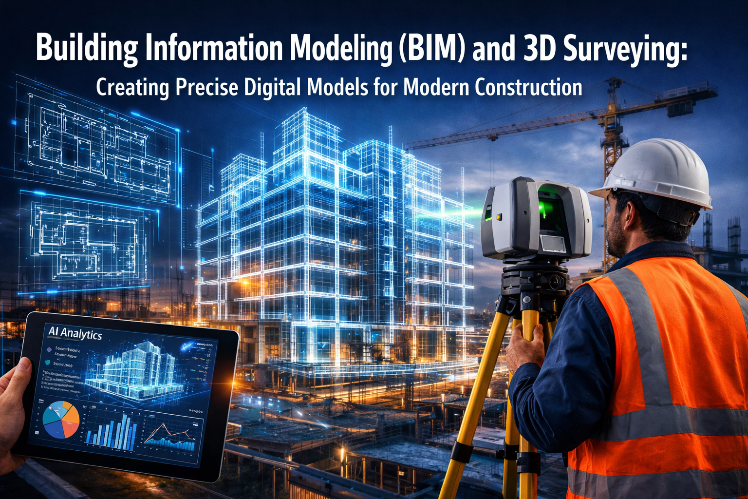
The construction industry stands at a technological crossroads in 2026, where traditional blueprints and manual surveying methods are rapidly giving way to intelligent digital ecosystems. Building Information Modeling (BIM) and 3D Surveying: Creating Precise Digital Models for Modern Construction represents more than just a technological upgrade—it's a fundamental transformation in how buildings are conceived, designed, constructed, and managed throughout their entire lifecycle. With 60% of construction firms now integrating BIM into their processes and 68% of BIM professionals reporting best-in-class ROI, the convergence of advanced surveying techniques with AI-powered analytics is revolutionizing project feasibility predictions, slashing construction errors, and enabling surveyors to create digital models with unprecedented accuracy[4][5].
Key Takeaways
- BIM adoption has reached critical mass with 60% of construction firms integrating the technology, while 85% of professionals expect it to become moderately or highly prevalent within the next decade[4][5]
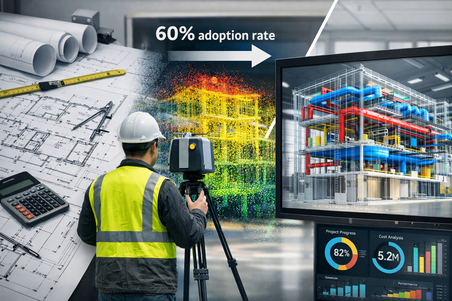
- 3D surveying technologies including LiDAR, drones, and mobile scanning enable real-time point cloud data collection that feeds directly into BIM models, eliminating traditional survey delays and improving accuracy[5]
- AI integration is transforming BIM workflows by automating clash detection, optimizing layouts, and generating design alternatives, with current adoption at 25% but expected to surge dramatically[4]
- Multi-dimensional BIM extends beyond 3D geometry to incorporate 4D scheduling, 5D cost management, and 6D facility lifecycle management, creating intelligent living models that serve projects from conception through demolition[4]
- Cloud-based collaboration platforms and Common Data Environments (CDE) enable seamless real-time coordination between architects, engineers, contractors, and building surveyors, reducing errors and accelerating project delivery[1][4]
Understanding Building Information Modeling (BIM) and 3D Surveying Integration
What Is Building Information Modeling?
Building Information Modeling represents a centralized digital ecosystem that captures the physical and functional characteristics of buildings and infrastructure projects. Unlike traditional Computer-Aided Design (CAD) systems that produce static 2D drawings or simple 3D visualizations, BIM creates intelligent, data-rich models following standardized practices outlined in the ISO 19650 series[2].
These models contain far more than geometric information. Each component within a BIM model—from structural beams to HVAC ducts to electrical conduits—carries embedded data about:
- Material specifications and manufacturer details
- Performance characteristics and thermal properties
- Cost information and procurement data
- Installation sequences and construction methodology
- Maintenance requirements and lifecycle expectations
- Sustainability metrics and environmental impact
This wealth of information transforms construction planning from a document-based process into an integrated data management system where every stakeholder accesses the same accurate, up-to-date information[2].
The Role of 3D Surveying in Modern Construction
Traditional surveying methods—while accurate—often created bottlenecks in project timelines. Surveyors would spend days or weeks collecting measurements manually, processing data offline, and delivering static reports that quickly became outdated as projects progressed.
Modern 3D surveying technologies have revolutionized this workflow through:
🔹 LiDAR (Light Detection and Ranging) systems that capture millions of precise measurement points per second, creating detailed "point clouds" representing existing conditions
🔹 Drone-based photogrammetry enabling rapid aerial surveys of large sites, capturing topographic data and progress documentation without disrupting ground operations
🔹 Mobile scanning systems like the Trimble X9 that surveyors can deploy to capture comprehensive 3D point clouds for site surveys and detailed BIM integration work[4]
🔹 Terrestrial laser scanners providing millimeter-level accuracy for complex renovation projects and infrastructure assessments
The game-changing advantage? These technologies enable real-time data collection that feeds directly into BIM platforms, creating continuously updated digital twins of construction sites[1][5]. For professionals conducting land surveying or structural surveys, this integration dramatically improves both speed and accuracy.
How BIM and 3D Surveying Work Together
The synergy between Building Information Modeling and 3D surveying creates a powerful feedback loop:
- Initial Site Assessment: Surveyors deploy 3D scanning technologies to capture existing conditions with extreme precision
- Point Cloud Processing: Raw survey data transforms into georeferenced point clouds that establish the digital foundation
- BIM Model Creation: Architects and engineers build design models directly on top of accurate survey data
- Continuous Verification: Throughout construction, ongoing 3D surveys compare as-built conditions against the BIM model
- Real-time Updates: Discrepancies trigger model updates, ensuring the digital twin remains synchronized with physical reality
This integration proves particularly valuable for renovation and infrastructure projects, where understanding existing conditions accurately determines project feasibility and cost estimates[5].
The Technology Stack Behind Building Information Modeling (BIM) and 3D Surveying
Core BIM Software Platforms
The BIM software landscape in 2026 offers specialized solutions for different project types and workflows. Leading platforms include:
| Software | Primary Use | Key Strengths |
|---|---|---|
| Autodesk Revit | Architectural design & MEP coordination | Industry standard, extensive plugin ecosystem |
| Bentley MicroStation | Infrastructure & civil engineering | Advanced parametric modeling for complex projects |
| Graphisoft ARCHICAD | Residential & commercial architecture | Intuitive interface, strong visualization tools |
| Tekla Structures | Structural steel & concrete detailing | Precise fabrication-level modeling |
| Vectorworks | Landscape architecture & entertainment | Versatile cross-industry capabilities |
Each platform supports open BIM standards like IFC (Industry Foundation Classes), enabling interoperability between different software systems and ensuring project data remains accessible regardless of which tools stakeholders prefer[6].
Advanced 3D Surveying Equipment
Modern surveying technology combines hardware precision with intelligent software processing:
Laser Scanning Systems capture environments at unprecedented speed and accuracy. The Trimble X9, for example, automatically registers scan positions and delivers point clouds ready for immediate BIM integration[4]. These systems prove invaluable for professionals conducting condition surveys or detailed property assessments.
Drone Technology has democratized aerial surveying. Equipped with high-resolution cameras and GPS systems, drones create orthomosaic maps and 3D terrain models that previously required expensive aerial photography flights. This accessibility benefits even smaller projects requiring accurate topographic data.
Mobile Mapping Systems combine LiDAR scanners with cameras and inertial measurement units, allowing surveyors to capture data while walking through buildings or driving along infrastructure corridors. This mobility dramatically reduces survey time while maintaining centimeter-level accuracy.
Cloud-Based Collaboration Platforms
The shift to cloud-based BIM platforms represents one of the most significant workflow improvements in recent years. These systems deliver:
✅ Instant file sharing eliminating version control nightmares
✅ Browser-based 3D visualization allowing stakeholders to review models without specialized software
✅ Real-time revision syncing ensuring everyone works from current information
✅ Integrated communication tools connecting conversations directly to model elements
✅ Mobile access enabling field teams to reference BIM data on tablets and smartphones
This cloud infrastructure replaces the traditional static document delivery model where outdated drawings caused costly construction errors[1]. The Common Data Environment (CDE) concept ensures architects, engineers, contractors, and facility managers collaborate seamlessly within a single source of truth[4].
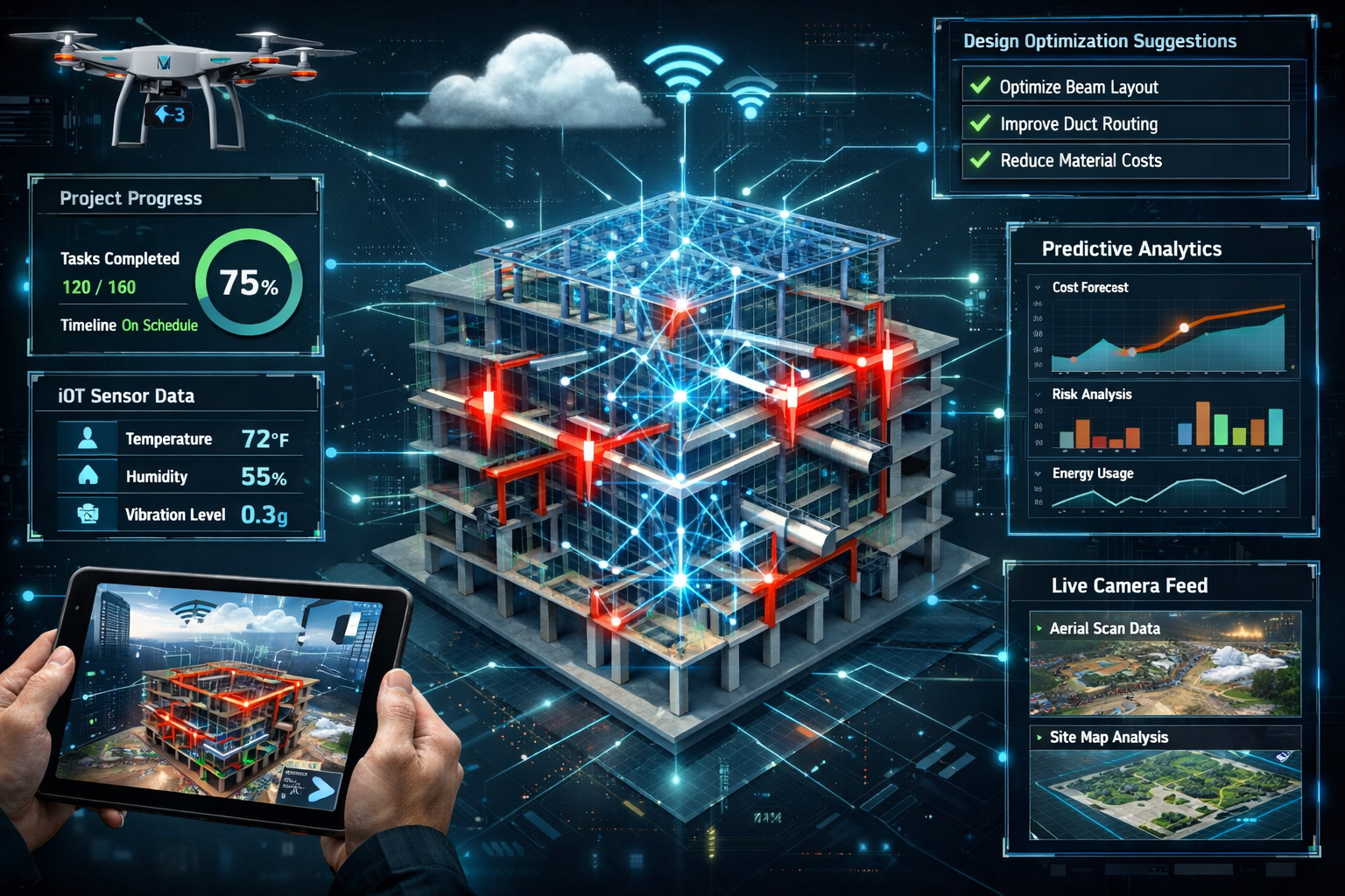
IoT Integration and Smart Sensors
The convergence of BIM with Internet of Things (IoT) technology creates cyber-physical systems that bridge digital models and physical construction. Smart sensors deployed throughout construction sites:
- Track construction progress automatically, updating BIM models with completion percentages
- Monitor equipment performance and location, optimizing resource allocation
- Measure environmental conditions like temperature and humidity affecting material installation
- Detect safety hazards and alert supervisors to dangerous conditions
- Provide live 3D visualization of actual site conditions compared to planned sequences
This IoT integration reduces errors and optimizes decision-making by replacing manual progress tracking with automated, objective data collection[2]. For property inspections and ongoing monitoring, this technology enables continuous assessment rather than periodic snapshots.
AI-Powered Analytics Transforming Building Information Modeling (BIM) and 3D Surveying
Current State of AI in Construction
While only 25% of Architecture, Engineering, and Construction (AEC) professionals currently use AI in their workflows, this adoption rate is poised for explosive growth[4]. The technology has matured beyond experimental applications to deliver tangible value in several critical areas.
AI algorithms trained on thousands of completed projects now recognize patterns that human reviewers might miss, identify optimal solutions faster than traditional methods, and predict potential problems before they manifest on site.
Automated Clash Detection and Resolution
One of BIM's most celebrated benefits—early-phase clash detection—prevents conflicts between Mechanical, Electrical, and Plumbing (MEP) systems and structural elements before construction begins[4]. Traditionally, this required experienced coordinators to manually review models, a time-consuming process prone to oversight.
AI-powered clash detection transforms this workflow by:
🔸 Automatically scanning entire models in minutes rather than hours
🔸 Prioritizing conflicts by severity and construction impact
🔸 Suggesting resolutions based on learned patterns from similar projects
🔸 Predicting downstream effects of proposed changes
🔸 Learning from corrections to improve future detection accuracy
This automation eliminates costly on-site adjustments that traditionally occurred when trades discovered conflicts during installation. The savings in both time and materials can reach hundreds of thousands of dollars on large projects.
Generative Design and Layout Optimization
AI enables generative design capabilities where algorithms explore thousands of design variations based on defined parameters and constraints. Architects and engineers specify requirements like:
- Building footprint and height restrictions
- Structural loading requirements
- Energy efficiency targets
- Material cost constraints
- Aesthetic preferences
The AI then generates multiple optimized solutions that meet these criteria, often discovering innovative approaches that wouldn't occur to human designers. This technology proves particularly valuable for complex projects where competing requirements demand careful balancing.
For surveyors, AI-powered analysis of 3D scan data can automatically identify:
- Structural deformations indicating potential problems
- Dimensional discrepancies between design intent and as-built conditions
- Material deterioration patterns requiring attention
- Optimal measurement point placement for future monitoring
These capabilities enhance the value of building surveys by extracting insights that manual analysis might overlook.
Predictive Analytics for Project Feasibility
AI algorithms trained on historical project data can predict project outcomes with increasing accuracy. By analyzing factors like:
- Site conditions and accessibility
- Design complexity metrics
- Local labor availability and skill levels
- Material supply chain variables
- Weather patterns and seasonal factors
- Regulatory approval timelines
These systems generate probability-weighted forecasts for project duration, budget requirements, and potential risk factors. This predictive capability helps stakeholders make informed decisions during feasibility assessment, reducing the likelihood of projects that exceed budgets or timelines.
When integrated with accurate 3D survey data, these predictions become even more reliable. The precise site information eliminates assumptions about existing conditions that frequently derail projects during construction.
Machine Learning for Quality Control
Computer vision algorithms can analyze construction progress photos and 3D scans to automatically verify work quality. The system compares actual installation against BIM specifications, flagging:
- Components installed in wrong locations
- Incorrect materials or finishes
- Workmanship defects requiring correction
- Missing elements or incomplete work
- Safety compliance issues
This automated quality control supplements rather than replaces human inspection, allowing supervisors to focus attention where algorithms detect potential problems. The result is more consistent quality and fewer defects requiring expensive remediation.
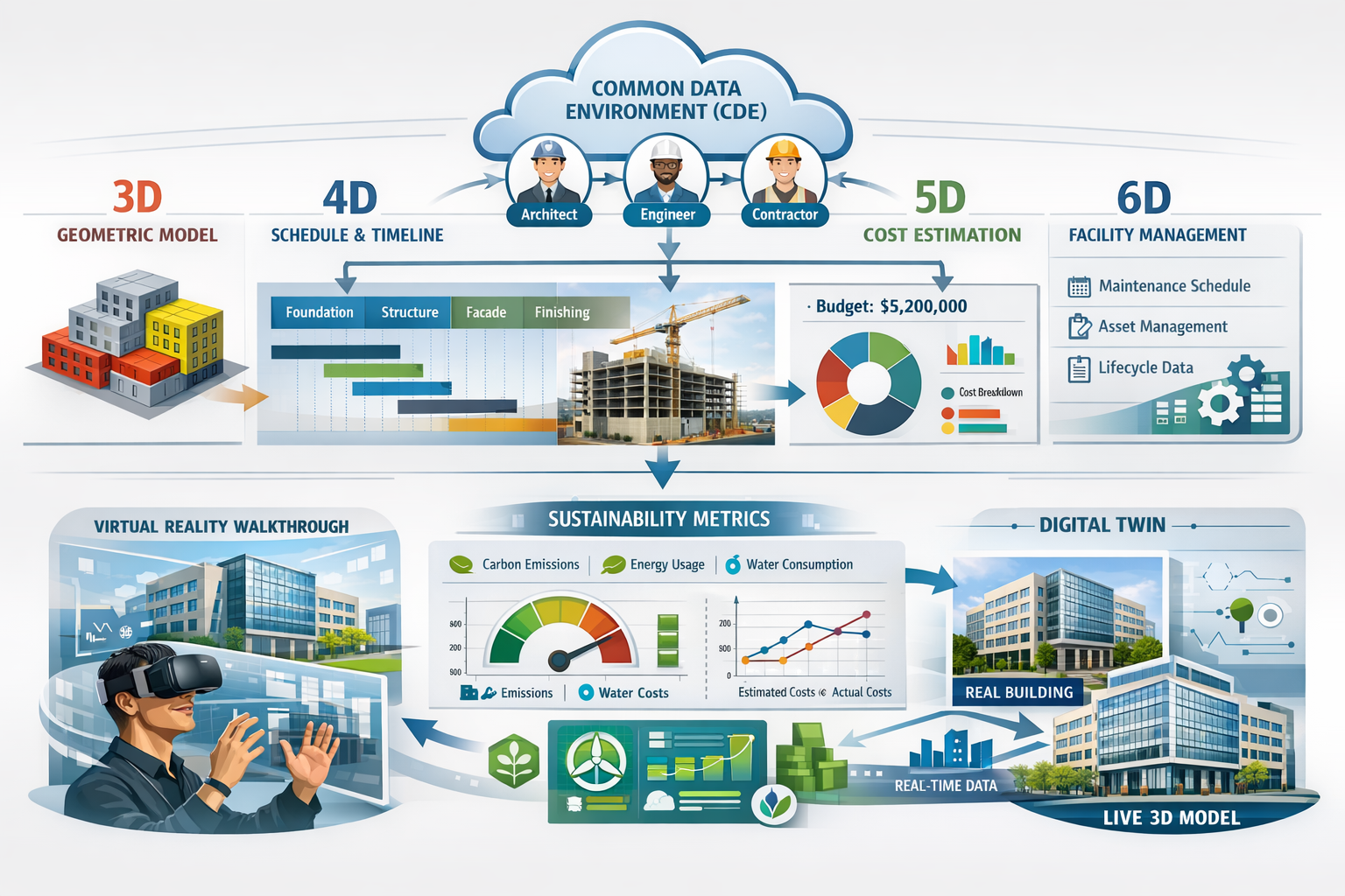
Multi-Dimensional BIM: Beyond 3D Geometry
The Evolution from 3D to 6D BIM
While most people associate BIM with 3D geometric modeling, the technology has evolved to incorporate additional dimensions that transform how projects are planned, executed, and managed:
3D – Geometric Modeling: The foundation—accurate spatial representation of all building components with material properties and specifications
4D – Time and Scheduling: Integration of construction sequences and timelines, enabling visualization of how the building will be constructed over time. This dimension allows project managers to:
- Simulate construction sequences to identify logistical conflicts
- Optimize resource allocation across project phases
- Communicate schedules visually to all stakeholders
- Identify opportunities to accelerate critical path activities
5D – Cost Management: Budget integration that links every model element to cost data, providing:
- Real-time cost estimation as designs evolve
- Automated quantity takeoffs eliminating manual counting
- What-if scenario analysis for value engineering
- Cash flow projections based on construction sequences
- Change order impact assessment
6D – Facility Lifecycle Management: Extension beyond construction into operational phases, capturing:
- Maintenance schedules and procedures
- Equipment warranties and service requirements
- Energy consumption and sustainability metrics
- Space utilization and occupancy data
- Asset replacement planning
Some industry professionals even discuss 7D – Sustainability Analysis, focusing specifically on environmental impact throughout the building lifecycle[4].
4D Scheduling and Construction Sequencing
The integration of time into BIM models creates powerful visualization tools for construction planning. Project managers can simulate the entire construction process, watching the building rise virtually before physical work begins.
This 4D capability reveals:
- Spatial conflicts between concurrent activities
- Access requirements for equipment and materials
- Temporary works needed to support construction sequences
- Site logistics optimization for material storage and workforce movement
- Critical dependencies between different trades
For complex projects, this visualization proves invaluable in communicating plans to all stakeholders. Rather than interpreting Gantt charts and written schedules, team members can literally watch their work unfold in the digital model.
5D Cost Integration and Budget Control
Linking cost data directly to BIM elements revolutionizes budget management. Traditional cost estimation required quantity surveyors to manually measure drawings and count components—a time-consuming process that quickly became outdated as designs changed.
With 5D BIM, cost estimates update automatically as the model evolves. Change a wall specification from brick to stone? The cost impact appears immediately. Resize a room? Quantities adjust instantly.
This real-time cost visibility enables:
- Continuous value engineering throughout design development
- Informed decision-making with immediate budget feedback
- Accurate change order pricing eliminating disputes
- Cash flow forecasting based on construction sequences
- Cost control through variance analysis
For clients considering property purchases or renovation projects, this transparency provides confidence that budgets reflect current design intent.
6D Facility Management and Lifecycle Planning
The true value of BIM extends far beyond construction completion. 6D facility management transforms the BIM model into an operational asset that building owners and facility managers use throughout the building's life.
The model becomes a comprehensive database containing:
- Equipment specifications and installation dates
- Maintenance procedures and service intervals
- Warranty information and manufacturer contacts
- Spare parts catalogs and replacement procedures
- Energy consumption baselines and efficiency targets
- Space allocation and utilization metrics
When maintenance issues arise, facility managers can query the model to understand exactly what equipment exists, how to access it, and what procedures apply. This eliminates the common problem of incomplete or outdated facility documentation.
For properties requiring ongoing maintenance assessments, the 6D BIM model provides unprecedented insight into building systems and their condition.
Real-World Applications and Benefits
Renovation and Heritage Conservation Projects
3D surveying proves absolutely critical for renovation projects where accurate documentation of existing conditions determines feasibility and cost. Traditional measurement methods struggle with complex geometries, irregular surfaces, and hard-to-access areas.
Laser scanning captures these challenging environments completely, creating point clouds that reveal:
- Structural deformations and settlement patterns
- Dimensional variations from original construction
- Hidden conditions behind finishes
- Spatial relationships between building systems
- Clearances and access constraints
When this survey data integrates with BIM, architects can design renovations with confidence that new elements will fit existing conditions. The digital model highlights conflicts before fabrication, eliminating the costly "measure twice, cut once" approach that often becomes "measure, cut, discover it doesn't fit, improvise."
For heritage conservation, non-contact 3D scanning documents historic structures without physical impact. The resulting models preserve detailed records of architectural features, enabling accurate restoration and providing invaluable documentation for future generations.
Infrastructure and Civil Engineering Projects
Large-scale infrastructure projects—highways, bridges, tunnels, utilities—benefit enormously from Building Information Modeling and 3D surveying integration. These projects span vast areas with complex existing conditions that traditional surveying methods struggle to capture efficiently.
Drone-based surveys create comprehensive topographic models of entire corridors in hours rather than weeks. This rapid data collection enables:
- Corridor optimization to minimize earthwork and environmental impact
- Utility conflict identification before excavation begins
- Drainage analysis using accurate terrain models
- Stakeholder visualization of proposed infrastructure in context
- Construction progress monitoring through periodic resurveys
The BIM models for infrastructure projects coordinate multiple disciplines—roadway design, structural engineering, drainage systems, utilities, landscaping—ensuring all elements work together harmoniously.
MEP Coordination and Clash Prevention
Perhaps nowhere does BIM deliver more obvious value than in Mechanical, Electrical, and Plumbing (MEP) coordination. Modern buildings contain incredibly complex networks of ducts, pipes, conduits, and equipment competing for limited space above ceilings and within walls.
Before BIM, these systems were designed separately on 2D drawings. Conflicts emerged during construction when trades discovered their work physically interfered with others—a duct occupying the same space as a structural beam, a pipe blocking access to electrical panels, insufficient clearance for equipment maintenance.
BIM enables virtual coordination where all MEP systems exist together in the 3D model alongside structural elements. Automated clash detection identifies thousands of potential conflicts, allowing coordination teams to resolve them digitally. The coordinated model then guides installation, with fabrication drawings generated directly from the clash-free 3D design.
This coordination occurs within the Common Data Environment (CDE) where all project stakeholders access the same current information[4]. The result? Dramatically reduced field conflicts, faster installation, and buildings that perform as designed.
Sustainability and Environmental Analysis
Land surveyors increasingly play crucial roles in assessing and mitigating environmental impacts, with growing emphasis on sustainability and responsible land development[1]. The integration of surveying data with BIM enables sophisticated environmental analysis:
- Solar exposure modeling for renewable energy optimization
- Stormwater runoff simulation to minimize environmental impact
- Material quantity optimization reducing waste
- Energy performance analysis using accurate building geometry
- Lifecycle carbon assessment from construction through operation
The digital twin concept—where BIM models continuously update to reflect actual building performance—enables ongoing sustainability monitoring. IoT sensors feed real-time data into the model, allowing facility managers to identify efficiency opportunities and verify that buildings achieve their environmental targets[1].
Emerging Technologies Shaping the Future
Augmented and Virtual Reality Integration
The integration of AR/VR technologies with BIM is accelerating rapidly, with headset shipments projected to increase from 6.7 million in 2024 to nearly 23 million by 2028[4]. This growth reflects increasing recognition of AR/VR's value in construction workflows.
Virtual Reality enables clients to "walk through" buildings before construction begins, experiencing spatial relationships and design decisions in an immersive environment. This capability dramatically improves design communication, allowing stakeholders to identify issues that aren't obvious in traditional 2D drawings or even 3D model viewers.
For contractors, VR creates safe training environments where workers can practice complex procedures without risk. Welders can rehearse difficult joints, crane operators can simulate lifts, and assembly teams can coordinate sequences—all in virtual space before attempting physical work.
Augmented Reality overlays BIM data onto the real world through tablets or AR glasses. Workers on site can see exactly where components should be installed, comparing design intent against actual conditions. This technology reduces errors and accelerates installation by eliminating the need to constantly reference drawings.
Surveyors benefit from AR visualization of survey data, with point clouds and measurement information overlaid on the physical environment. This capability aids in explaining findings to clients and identifying areas requiring additional investigation.
Real-Time Digital Twins
Real-time 3D digital twins represent a key advancement, allowing developers, engineers, and planners to visualize how land parcels and buildings behave under various conditions with continuously updating models[1]. Unlike static BIM models that represent design intent, digital twins reflect actual current conditions.
IoT sensors throughout buildings feed data streams into the digital twin:
- Structural sensors monitoring movement and stress
- Environmental sensors tracking temperature, humidity, air quality
- Energy meters measuring consumption patterns
- Occupancy sensors recording space utilization
- Equipment monitors reporting performance and maintenance needs
This real-time data enables predictive maintenance where algorithms identify developing problems before failures occur. Facility managers can optimize operations based on actual usage patterns rather than assumptions, and building owners can demonstrate performance to tenants and regulators.
For surveyors conducting dilapidations assessments, digital twins provide comprehensive condition documentation and historical performance data that traditional surveys cannot match.
Blockchain for Project Documentation
Emerging applications of blockchain technology in construction focus on creating immutable records of project decisions, changes, and approvals. In an industry plagued by disputes over who authorized what changes and when, blockchain offers transparent, tamper-proof documentation.
When integrated with BIM workflows, blockchain can record:
- Design decision approvals with timestamps
- Change order authorizations and pricing
- Material certifications and test results
- Inspection reports and compliance verification
- Payment milestones and completion certificates
This documentation proves particularly valuable for complex projects with multiple stakeholders where accountability and traceability matter.
Advanced Materials and Prefabrication
BIM enables off-site prefabrication where building components are manufactured in controlled factory environments and assembled on site. The precise geometric data in BIM models drives automated fabrication equipment, producing components that fit together with minimal field adjustment.
This prefabrication approach offers multiple benefits:
- Quality control in factory conditions
- Faster construction with reduced site labor
- Weather independence for component production
- Waste reduction through optimized manufacturing
- Safety improvements by moving work off-site
Advanced materials with embedded sensors—smart concrete that monitors its own curing and structural performance, self-healing materials that repair minor damage automatically—integrate naturally with BIM digital twins, reporting their condition continuously.
Implementation Challenges and Solutions
Skills Gap and Training Requirements
The rapid advancement of Building Information Modeling and 3D surveying technologies creates significant skills challenges. Traditional construction professionals trained on 2D drawings must adapt to 3D digital workflows, while younger workers enter the industry expecting modern technology but often lacking fundamental construction knowledge.
Addressing this skills gap requires:
- Formal education programs integrating BIM into construction management and engineering curricula
- Professional development for experienced workers transitioning to digital workflows
- Certification programs validating BIM competency levels
- Mentorship systems pairing experienced construction professionals with digitally-native younger workers
- Vendor training on specific software platforms and equipment
Organizations that invest in comprehensive training see faster adoption, better utilization of technology capabilities, and improved project outcomes. Those that simply purchase software without supporting skill development often struggle to realize BIM's full potential.
Data Management and Standardization
As BIM models grow in complexity and detail, data management becomes increasingly challenging. A single large project might generate terabytes of data including:
- BIM models from multiple disciplines
- Point cloud surveys from various project phases
- Photographs and documentation
- Specifications and product data
- Correspondence and approvals
- Cost and scheduling information
Without proper data governance, this information becomes overwhelming rather than useful. The ISO 19650 series provides standardized frameworks for BIM data management, addressing:
- Information requirements definition
- Data exchange protocols
- Common file naming conventions
- Version control procedures
- Security and access management
- Archival and handover processes
Organizations implementing these standards find that consistent data management practices dramatically improve collaboration efficiency and reduce errors caused by working from outdated information.
Interoperability Between Systems
Despite progress toward open BIM standards, interoperability challenges persist. Different software platforms handle data differently, and information can be lost or corrupted during file exchanges. Geometry might transfer correctly while embedded data disappears, or material specifications might change during format conversions.
Solutions include:
- IFC (Industry Foundation Classes) as a neutral exchange format
- BCF (BIM Collaboration Format) for communicating issues between platforms
- COBie (Construction Operations Building Information Exchange) for facility management data
- Direct API integrations between commonly used software combinations
- Middleware platforms that translate between different systems
Project teams should establish and test data exchange protocols early, verifying that critical information transfers correctly between all required platforms. This upfront investment prevents costly problems during coordination and construction phases.
Cost and ROI Considerations
Implementing comprehensive BIM and 3D surveying capabilities requires significant investment in:
- Software licenses and subscriptions
- Hardware including workstations, scanning equipment, and mobile devices
- Cloud infrastructure and data storage
- Training and skill development
- Process development and standardization
- Technical support and troubleshooting
For smaller firms, these costs can seem prohibitive. However, 68% of BIM professionals report it's delivering the best ROI for their projects, with benefits including[4]:
- Reduced rework from clash detection and coordination
- Faster project delivery through improved communication
- Lower construction costs from quantity optimization
- Fewer change orders due to better design clarity
- Improved client satisfaction leading to repeat business
- Competitive advantage in winning new projects
Organizations should view BIM implementation as a strategic investment rather than a technology expense. Starting with pilot projects allows teams to develop capabilities gradually while demonstrating value to stakeholders. As expertise grows and processes mature, the technology can expand to more complex applications.
For property surveyors considering whether to adopt 3D scanning and BIM integration, the competitive landscape increasingly demands these capabilities. Clients expect comprehensive digital deliverables, and projects require survey data in BIM-compatible formats.
Best Practices for Successful Implementation
Establishing Clear BIM Execution Plans
Every project should begin with a BIM Execution Plan (BEP) that defines:
- Project goals and specific BIM use cases
- Roles and responsibilities for each team member
- Software platforms and file formats to be used
- Data exchange protocols and schedules
- Level of detail required at each project phase
- Quality control procedures and review milestones
- Deliverable requirements for project completion
This planning document ensures all stakeholders understand expectations and workflows before work begins. Without clear BEP definition, projects often struggle with mismatched assumptions about who is responsible for what information and when it should be delivered.
Defining Level of Detail Requirements
BIM models can range from conceptual massing to fabrication-level precision. The appropriate Level of Detail (LOD) depends on project phase and intended use:
- LOD 100: Conceptual representation showing basic massing and orientation
- LOD 200: Approximate geometry with general quantities and performance
- LOD 300: Precise geometry suitable for coordination and documentation
- LOD 350: Coordination level including interfaces with other systems
- LOD 400: Fabrication detail sufficient for manufacturing
- LOD 500: As-built verification representing actual installed conditions
Defining LOD requirements prevents wasted effort modeling unnecessary detail while ensuring critical information is captured. Early design phases rarely require LOD 400 precision, while fabrication and renovation projects demand it.
Implementing Common Data Environments
The Common Data Environment (CDE) serves as the single source of truth for project information[4]. All stakeholders access current data through the CDE rather than maintaining separate file repositories that quickly diverge.
Effective CDE implementation requires:
- Clear folder structures organized by discipline and project phase
- Naming conventions that identify file content, version, and status
- Access controls ensuring appropriate security and permissions
- Workflow automation for review and approval processes
- Audit trails documenting who changed what and when
- Mobile access for field teams requiring real-time information
Cloud-based platforms like BIM 360, Trimble Connect, and Bentley ProjectWise provide comprehensive CDE capabilities. The investment in proper CDE setup pays dividends throughout the project in reduced coordination time and fewer errors.
Continuous Quality Assurance
Quality control in BIM workflows should be continuous rather than limited to periodic reviews. Automated checking tools can verify:
- Model integrity ensuring geometry is clean and complete
- Naming compliance with established conventions
- Data completeness confirming required properties are populated
- Clash detection between disciplines
- Standard compliance with project BEP requirements
Regular quality checks—ideally automated and running continuously—catch problems early when they're easy to fix. Waiting until major coordination reviews often means extensive rework to correct accumulated issues.
For surveyors, quality assurance includes verifying that 3D scan data meets accuracy requirements, contains sufficient detail, and registers correctly to project coordinate systems. Point cloud quality directly impacts BIM model accuracy, making survey QA critical to overall project success.
The Future Outlook for 2026 and Beyond
Accelerating Adoption Rates
With over 85% of professionals expecting BIM to be moderately or highly prevalent within the next decade, the technology is clearly moving from early adoption to industry standard[4]. Several factors drive this acceleration:
- Client requirements increasingly mandate BIM deliverables
- Government mandates in many countries require BIM for public projects
- Insurance considerations recognize BIM's risk reduction value
- Competitive pressure as firms with BIM capabilities win more projects
- Generational change as digitally-native professionals enter the workforce
Organizations that haven't yet embraced BIM face growing competitive disadvantages. The question has shifted from "Should we adopt BIM?" to "How quickly can we build these capabilities?"
Integration with Smart City Initiatives
BIM models increasingly feed into smart city platforms that integrate building data with urban infrastructure systems. This integration enables:
- Energy grid optimization based on building consumption patterns
- Transportation planning informed by building occupancy data
- Emergency response with accurate building layouts and systems information
- Urban planning using aggregated building performance data
- Sustainability monitoring at neighborhood and city scales
The digital twins of individual buildings become nodes in larger urban digital twins, creating unprecedented visibility into how cities function and opportunities for optimization.
Democratization Through Cloud Technology
Cloud-based platforms are democratizing access to BIM capabilities that previously required expensive workstations and software licenses. Browser-based viewers allow stakeholders to access models from any device, while cloud computing handles processing-intensive tasks like rendering and simulation.
This accessibility means smaller firms and individual professionals can participate in BIM workflows without massive capital investment. The subscription model for software also reduces barriers to entry, allowing organizations to scale capabilities up or down based on current project needs.
Sustainability and Climate Resilience
As climate change drives increasing focus on building sustainability and resilience, BIM provides essential tools for analysis and optimization. The ability to model energy performance, simulate climate scenarios, and optimize material usage makes BIM central to achieving carbon reduction targets.
Future developments will likely include:
- Embodied carbon calculators integrated directly into BIM platforms
- Climate resilience analysis for extreme weather and sea level rise
- Circular economy tracking for material reuse and recycling
- Biodiversity impact assessment for site development
- Water conservation modeling and greywater system optimization
The surveying profession's growing emphasis on environmental impact assessment positions surveyors as key contributors to sustainable development[1]. Integrating survey data with environmental analysis tools within BIM platforms will enhance this contribution.
Conclusion
Building Information Modeling (BIM) and 3D Surveying: Creating Precise Digital Models for Modern Construction represents far more than technological advancement—it embodies a fundamental transformation in how the built environment is conceived, realized, and managed. The convergence of intelligent digital modeling, precision surveying technologies, and AI-powered analytics is delivering measurable value through reduced errors, accelerated delivery, improved collaboration, and enhanced sustainability.
With 60% of construction firms already integrating these capabilities and 68% reporting best-in-class ROI, the business case is clear[4][5]. The technology has matured beyond experimental applications to become essential infrastructure for competitive construction practice in 2026.
For surveyors, the integration of 3D scanning technologies with BIM workflows elevates the profession's value proposition. No longer limited to delivering static measurement reports, modern surveyors provide dynamic digital models that serve as project foundations from feasibility through facility management. This evolution requires new skills and capabilities, but offers tremendous opportunities for those who embrace it.
Actionable Next Steps
For Organizations Beginning BIM Implementation:
- Start with pilot projects to develop capabilities gradually while demonstrating value
- Invest in training as the foundation for successful technology adoption
- Establish clear standards for data management and quality control
- Choose appropriate software based on project types and team skills
- Build partnerships with experienced BIM consultants for knowledge transfer
For Surveyors Integrating 3D Technologies:
- Assess equipment options matching scanning technology to typical project requirements
- Develop BIM integration workflows ensuring survey data feeds seamlessly into models
- Expand service offerings to include digital twin creation and ongoing monitoring
- Pursue relevant certifications validating 3D scanning and BIM competency
- Communicate value to clients through case studies demonstrating improved outcomes
For Project Stakeholders:
- Define BIM requirements clearly in project contracts and execution plans
- Establish Common Data Environments as single sources of truth
- Require regular model updates reflecting as-built conditions
- Plan for facility management from project inception, not as an afterthought
- Measure and communicate ROI to build support for continued investment
The future of construction is undeniably digital, intelligent, and integrated. Organizations that embrace Building Information Modeling and 3D surveying position themselves at the forefront of this transformation, delivering superior outcomes for clients while building competitive advantages that will serve them for decades to come. The technology exists, the business case is proven, and the time to act is now.
Whether conducting comprehensive building surveys, planning complex renovations, or managing large-scale infrastructure projects, the integration of BIM and 3D surveying provides the precision, insight, and collaboration capabilities that modern construction demands. The question is no longer whether to adopt these technologies, but how quickly your organization can build the capabilities to leverage them effectively.
References
[1] Future Land Surveying 2026 – https://haller-blanchard.com/future-land-surveying-2026/
[2] Bim Power Data Construction – https://www.rics.org/news-insights/bim-power-data-construction
[3] Evolving Construction Industry 2026 – https://hbrawm.com/blog/evolving-construction-industry-2026/
[4] Building Information Modelling Bim Everything You Need To Know – https://blog.brightergraphics.com/building-information-modelling-bim-everything-you-need-to-know
[5] Pre Construction Trends For Architects Engineers Homebuilders – https://www.awaydigital.com/pre-construction-trends-for-architects-engineers-homebuilders/
[6] Top 10 Bim Software You Need To Know – https://endeion.com/top-10-bim-software-you-need-to-know/
[7] Engineering And Construction Industry Outlook – https://www.deloitte.com/us/en/insights/industry/engineering-and-construction/engineering-and-construction-industry-outlook.html
[8] The Future Of Bim Emerging Trends And Technologies – https://business.bimobject.com/blog/the-future-of-bim-emerging-trends-and-technologies/