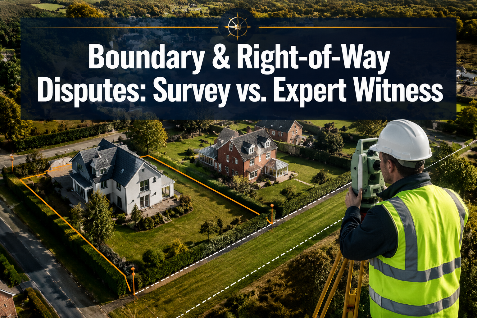
Land boundary disputes make up a substantial share of all civil property litigation in England and Wales — and the majority of those cases begin with a deceptively simple question: exactly where does one person's land end and another's begin? Boundary and Right-of-Way Disputes: When You Need a Measured Survey Versus an Expert Witness Valuation is a question that property owners, solicitors, and developers face with increasing frequency in 2026, particularly as urban infill, garden development, and permitted development rights push boundaries — quite literally — to their limits.
The confusion usually starts when owners discover that their title plan, their neighbour's title plan, and the physical features on the ground do not agree. At that point, three distinct professionals may enter the picture: a measured survey specialist, an expert witness valuation surveyor, and a party wall surveyor. Understanding which one you need — and when — can save thousands of pounds in unnecessary legal costs.
Key Takeaways
- A measured survey establishes the precise physical position of boundaries using instruments and historical deed evidence — it is the essential first step in most disputes.
- An expert witness valuation quantifies the financial impact of a boundary or right-of-way encroachment and provides court-admissible testimony on diminution in value or compensation.
- A party wall surveyor deals specifically with works that affect a shared wall or structure — a different role from either of the above.
- Hedge-and-ditch rules, mapping errors, and adverse possession claims each demand a different combination of these professionals.
- Instructing the wrong expert first is one of the most common — and costly — mistakes in property disputes.
Understanding the Three Key Professionals in Boundary Disputes
Before examining when each service is required, it is worth being precise about what each professional actually does.
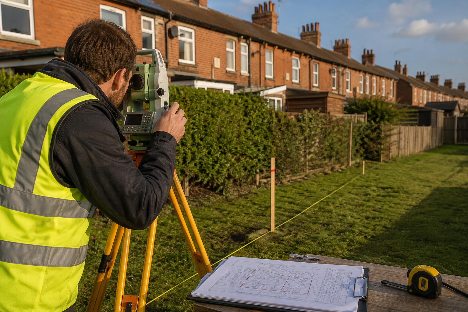
The Measured Survey Specialist
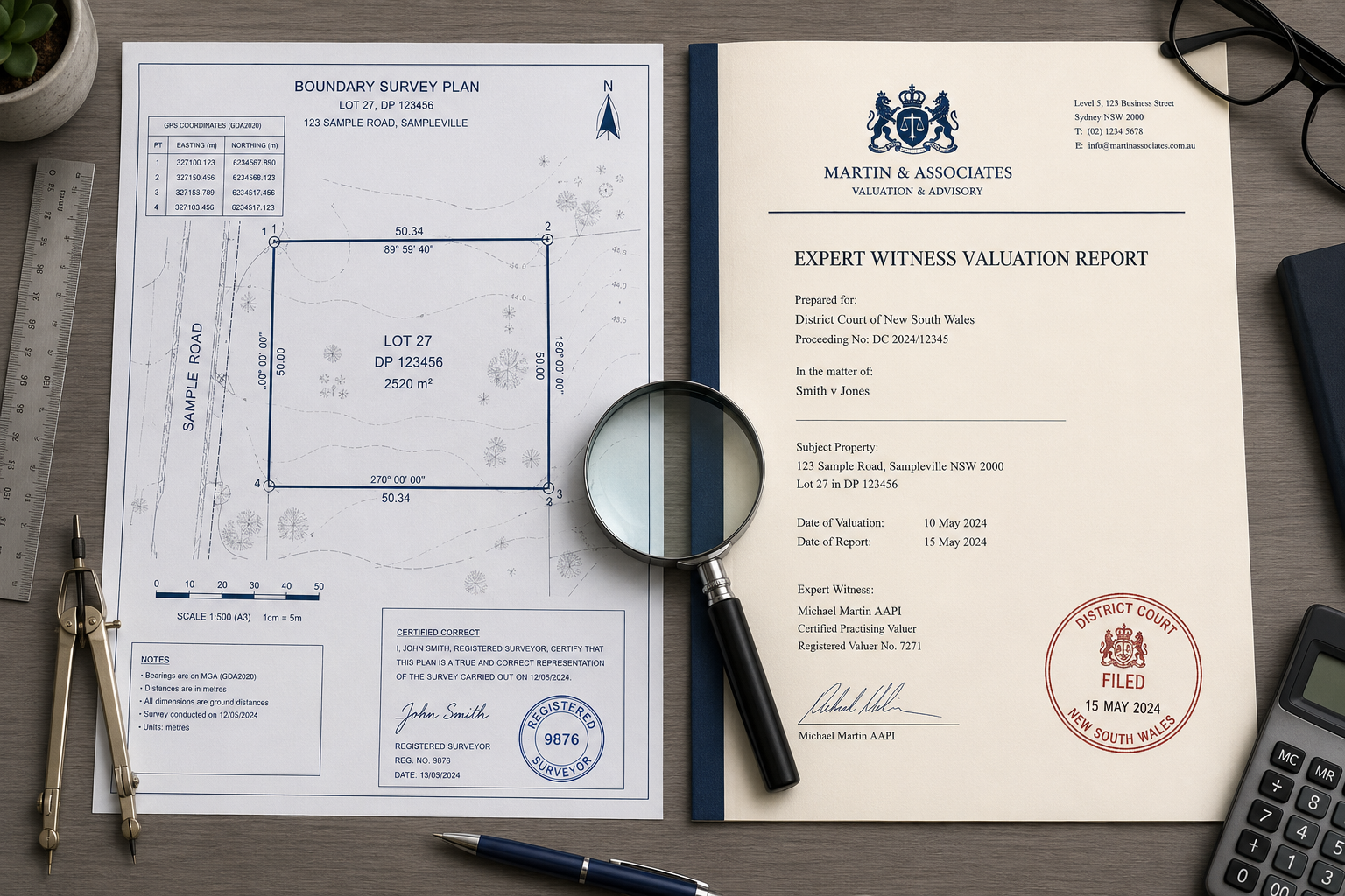
A measured boundary survey is a physical investigation of the land. A licensed surveyor researches historic title deeds, conveyance plans, and Ordnance Survey data, then visits the site to locate boundary features — walls, fences, hedges, ditches — and measures their exact positions using a total station, GPS equipment, or both. [1]
The output is a scaled plan showing the legal boundary line as derived from the documentary evidence, overlaid on the physical features found on the ground. Where those two things disagree, the surveyor explains why and what the discrepancy means legally.
This type of work sits at the heart of all boundary and right-of-way disputes. Without it, no other professional — not a solicitor, not a valuer, not a judge — can properly understand the spatial facts of the case. For a deeper look at the range of survey types available, the boundary survey resources published by RICS-regulated surveyors provide a useful starting point.
The Expert Witness Valuation Surveyor
Once the physical facts are established, a different question often arises: what is the financial consequence? An expert witness valuation surveyor is instructed to provide a formal opinion on value — typically the diminution in value of a property caused by an encroachment, the value of a strip of land in dispute, or the compensation payable for interference with a right of way. [3]
This professional prepares a court-compliant report under Civil Procedure Rules Part 35, meaning their primary duty is to the court rather than to the instructing party. Their report must be objective, evidenced, and defensible under cross-examination. [4]
A RICS property valuation carried out to Red Book standards forms the foundation of this type of expert evidence. In some cases, a Red Book valuation is specifically required by the court or by a lender involved in the dispute.
The Party Wall Surveyor
A party wall surveyor has a more narrowly defined statutory role under the Party Wall etc. Act 1996. They are appointed when a building owner proposes works that affect a shared wall, boundary wall, or excavation near a neighbouring property. Their job is to produce a Party Wall Award — a legally binding document that sets out how the works will proceed and protects both parties.
This is a distinct function from boundary determination or valuation. However, party wall matters and boundary disputes frequently overlap, particularly when a new extension is proposed close to a disputed line. For guidance on this intersection, the Party Wall Act explained and party wall surveyor services pages cover the procedural requirements in detail.
When a Measured Survey Is the Right Starting Point
For the vast majority of Boundary and Right-of-Way Disputes: When You Need a Measured Survey Versus an Expert Witness Valuation scenarios, a measured survey should come first. Here is why — and when it is non-negotiable.
Mapping Errors and Title Plan Discrepancies
HM Land Registry title plans are drawn at 1:1250 scale for urban properties. At that scale, a line of just one millimetre on the plan represents 1.25 metres on the ground. This means that the general boundary shown on a title plan carries a margin of error that can easily encompass a fence, a hedge, or even a narrow strip of garden.
When neighbours disagree about whether a fence has moved or whether a driveway encroaches, the first task is to establish what the deeds actually say — and whether the physical features match. A measured survey does exactly this. It translates the legal description into precise ground coordinates and identifies any discrepancy between what was conveyed and what exists today. [2]
Common triggers for a measured survey include:
- A fence or wall that appears to be in the wrong position
- A new development that seems to encroach on neighbouring land
- A driveway, outbuilding, or extension built close to a boundary
- A right of way that is obstructed or whose route is disputed
- Plans to sell, subdivide, or develop land where the boundary is unclear
Costs for a measured boundary survey in the UK typically range from £1,500 to £5,000 depending on the complexity of the title evidence and the size of the site, with a typical turnaround of two to four weeks. [1]
The Hedge-and-Ditch Presumption
One of the most misunderstood principles in English boundary law is the hedge-and-ditch rule. The presumption — established in Vowles v Miller (1810) and confirmed in subsequent cases — is that where a hedge and a ditch run alongside each other, the boundary lies at the far edge of the ditch from the hedge. The reasoning is that a landowner digging a boundary ditch would dig it at the edge of their own land and throw the spoil back onto their side to form a bank, on which a hedge would then grow.
This presumption can be rebutted by evidence to the contrary, but it catches many property owners off guard. A measured survey will identify the physical relationship between hedge and ditch, record their dimensions, and advise on whether the presumption applies — something that a title plan alone cannot do.
Adverse Possession Claims
Where a neighbour claims to have acquired title to a strip of land through long use — adverse possession — the measured survey becomes even more critical. The surveyor must establish:
- The exact position of the legal boundary as shown by the deeds
- The position of any physical feature that the claimant has treated as their boundary
- The area of land between those two lines
Without this spatial evidence, a solicitor cannot properly advise on the strength of an adverse possession claim, and a court cannot determine it. The UK boundary regulations and property line restrictions resources provide further context on how these legal frameworks interact with physical survey evidence.
When You Need an Expert Witness Valuation
A measured survey establishes the facts. An expert witness valuation quantifies their financial consequences. The two services are complementary, not interchangeable.
Compensation for Encroachment or Trespass
If a measured survey confirms that a neighbour's structure encroaches onto your land, the next question is: what is that worth? Courts dealing with boundary encroachments must decide whether to order removal of the offending structure or to award damages in lieu of an injunction. To make that decision, they need evidence of value.
An expert witness valuation surveyor will assess:
- The open market value of the encroached strip as a standalone piece of land
- The "ransom value" — the additional sum a buyer of the encroaching property would pay to regularise the title
- The diminution in value of the affected property caused by the encroachment
- In some cases, the cost of reinstatement
This is specialist work that requires both RICS valuation competence and experience of giving evidence in court. [4] A surveyor who is excellent at measured surveys may not be qualified or experienced in this role — and vice versa.
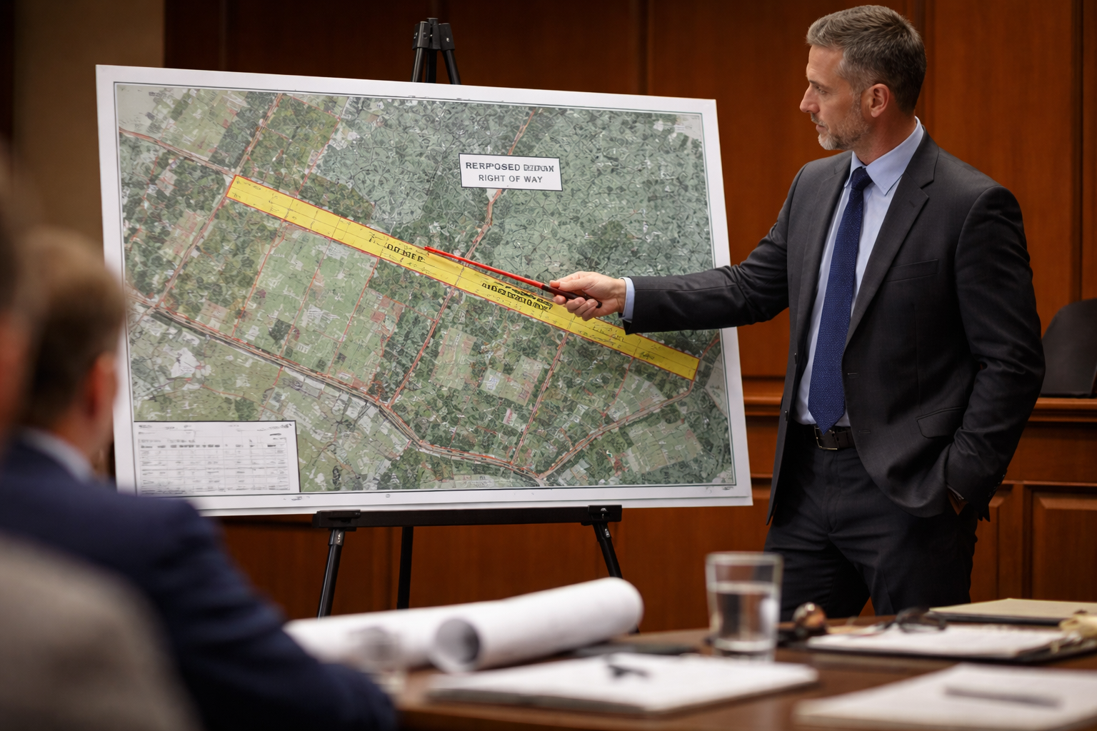
Right-of-Way Interference and Access Disputes
Right-of-way disputes present a particular valuation challenge. The value of a right of way to the dominant land (the land that benefits) may be very different from the burden it places on the servient land (the land over which it passes). Courts and tribunals dealing with modification or extinguishment of rights of way under the Law of Property Act 1925 require expert evidence on both sides of that equation.
An expert witness valuation surveyor can also assist where:
- A developer seeks to acquire a right of way over neighbouring land
- A right of way has been obstructed and the owner seeks damages
- A commercial lease or sale is complicated by an unregistered or disputed access
"The distinction between establishing where a boundary lies and establishing what that boundary is worth in financial terms is fundamental — conflating the two roles leads to confused evidence and weaker cases."
Litigation Support and Court-Ready Reports
Land boundary disputes constitute a significant portion of real property civil cases. [5] When a dispute reaches the Property Chamber of the First-tier Tribunal or the County Court, both the measured survey evidence and the valuation evidence must comply with strict procedural rules. Expert witnesses in surveying provide detailed evaluations and courtroom-defensible testimony that strengthen legal cases. [4]
A key distinction: a measured survey expert gives opinion evidence on where the boundary is. A valuation expert gives opinion evidence on what the financial consequences are. In complex cases, both may be required — and they should be instructed separately, with clear terms of reference for each.
Choosing the Right Surveyor for Boundary and Right-of-Way Disputes
A Practical Decision Framework
The table below summarises the three professional roles and the circumstances that call for each:
| Situation | Measured Survey | Expert Witness Valuation | Party Wall Surveyor |
|---|---|---|---|
| Fence or hedge position disputed | Yes | Sometimes | No |
| Encroachment confirmed, damages sought | Yes (first) | Yes (second) | No |
| Right of way obstructed | Yes | Yes | No |
| Adverse possession claim | Yes | Sometimes | No |
| New extension near boundary | Sometimes | No | Yes |
| Compensation for diminution in value | No | Yes | No |
| Hedge-and-ditch rule applies | Yes | No | No |
| Mapping error on title plan | Yes | No | No |
Questions to Ask Before Instructing
Before engaging any surveyor in a dispute context, consider these questions:
- Is the dispute primarily about where the boundary is, or about what it is worth? If the former, start with a measured survey. If the latter — and the boundary position is already agreed — go directly to a valuation expert.
- Is litigation already underway? If so, any expert must be instructed under CPR Part 35 protocols, with a letter of instruction that sets out the questions the court needs answered.
- Is there a party wall element? If proposed works are involved, a schedule of condition and formal party wall process may run in parallel with the boundary dispute.
- What does the title evidence show? A solicitor should review the deeds before a surveyor is instructed, to identify whether the boundary is a "general boundary" under the Land Registration Act 2002 or a "fixed boundary" determined by a previous court order or boundary agreement.
RICS Regulation and Professional Standards
All three professional roles described in this article are most reliably filled by surveyors regulated by the Royal Institution of Chartered Surveyors (RICS). RICS members are bound by professional standards, carry indemnity insurance, and can be held accountable through a formal complaints process. For boundary disputes specifically, look for surveyors with experience in the RICS Boundary Disputes Pathway and, for expert witness work, membership of the Expert Witness Institute or equivalent accreditation. [6]
Whether the property in question is in Barnet, Islington, Bromley, or any other part of London, the same professional standards apply. Local knowledge of how properties in a specific area were historically developed — terraced housing, garden subdivisions, former agricultural land — can be a significant advantage when interpreting ambiguous deed plans.
Common Mistakes That Escalate Boundary Disputes
Understanding Boundary and Right-of-Way Disputes: When You Need a Measured Survey Versus an Expert Witness Valuation also means recognising the errors that turn manageable disagreements into expensive litigation.
Mistake 1: Relying solely on the Land Registry title plan. As noted above, the general boundary shown on a title plan is not a precise legal boundary. Treating it as one is the single most common source of escalation. [2]
Mistake 2: Instructing a valuer before the boundary is established. A valuation of a disputed strip is meaningless if the area and legal status of that strip have not yet been determined by a measured survey.
Mistake 3: Confusing a party wall surveyor's role with boundary determination. A party wall surveyor acting under the 1996 Act has no jurisdiction to determine where a boundary lies. Their Award deals only with the works — not with title.
Mistake 4: Attempting DIY measurement. Consumer-grade GPS devices and laser measures are not accurate enough for legal boundary work. Courts have repeatedly declined to accept evidence based on measurements taken by non-qualified individuals.
Mistake 5: Delaying instruction. Physical evidence — the position of an old fence post, the line of a removed hedge — deteriorates over time. Early instruction of a measured survey specialist preserves evidence that may be critical later. [7]
Conclusion
Boundary and right-of-way disputes are rarely simple, but the path through them becomes much clearer when the right professional is instructed at the right stage. The measured survey specialist establishes the spatial facts — where the boundary actually is, what the deeds say, and how physical features relate to the legal line. The expert witness valuation surveyor then quantifies the financial consequences of those facts in a form that courts and tribunals can act on. The party wall surveyor handles the statutory process when construction works are involved.
Actionable next steps for property owners facing a dispute in 2026:
- Obtain and review all title deeds and conveyance plans before instructing anyone.
- Instruct a RICS-regulated measured survey specialist as the first step if the boundary position is in doubt.
- Engage a solicitor with property litigation experience to advise on whether expert witness evidence will be needed and under what procedural rules.
- If court proceedings are likely, ensure any expert is briefed under CPR Part 35 from the outset.
- Do not carry out any physical works — removing hedges, erecting fences, blocking access — until legal advice has been obtained, as this can prejudice your position significantly.
Taking these steps in the correct order reduces costs, preserves evidence, and gives any subsequent legal proceedings the strongest possible foundation.
References
[1] Boundary Survey – https://www.terravector.io/services/boundary-survey?utm_source=openai
[2] Property Boundaries Legal Descriptions Surveys Disputes – https://legalclarity.org/property-boundaries-legal-descriptions-surveys-disputes/?utm_source=openai
[3] Expert Witness – https://www.survtechsolutions.com/expert-witness?utm_source=openai
[4] Surveying – https://www.forensisgroup.com/forensis-expert-witness/expertise/surveying?utm_source=openai
[5] Land Boundaries – https://cnettleman.net/land-boundaries/?utm_source=openai
[6] lastevensinc – https://lastevensinc.com/?utm_source=openai
[7] cnettleman – https://cnettleman.net/?utm_source=openai