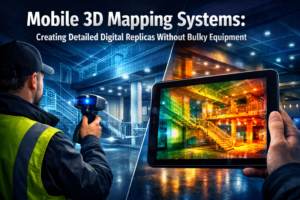
CONTACT

BLOGS

Our panel of surveyors provides a wide range of surveying services to people living in Wimbledon London and the Home Counties so that they can make well-informed choices about land and property. Your surveyors can undertake a Schedule of Condition for a detailed snapshot of the property condition in respect of party wall agreements. Wimbledon Surveyors can organise RICS valuers for lease agreements and property purchases. Expert chartered surveyors also deliver meticulous building surveys to safeguard your property interests. Surveying services cover residential, commercial, industrial and retail to deliver comprehensive property surveys.

OUR LATEST ARTICLE

Autonomous Drones in Land Surveying: Achieving Centimeter-Level Accuracy with Minimal Human Intervention

Autonomous Drones in Land Surveying: Achieving Centimeter-Level Accuracy with Minimal Human Intervention

The landscape of land surveying is experiencing a revolutionary transformation in 2026. Imagine a scenario where a property developer needs to survey a 500-acre construction site—a task that traditionally required weeks of manual labor, multiple survey teams, and significant safety risks. Today, autonomous drones in land surveying: achieving centimeter-level accuracy

READ MORE >>
AI-Driven Precision in Property Surveying: Revolutionizing Workflows in 2026

AI-Driven Precision in Property Surveying: Revolutionizing Workflows in 2026

The property surveying industry stands at a transformative crossroads in 2026. What once required multiple site visits, weeks of manual data processing, and extensive human interpretation can now be accomplished in a fraction of the time with unprecedented accuracy. AI-Driven Precision in Property Surveying: Revolutionizing Workflows in 2026 represents more

READ MORE >>
Real-Time 3D Digital Twins: Transforming Property Visualization and Decision-Making in 2026

Real-Time 3D Digital Twins: Transforming Property Visualization and Decision-Making in 2026

The property development landscape is experiencing a fundamental shift. Gone are the days when stakeholders relied solely on static blueprints and imagination to envision completed projects. Real-Time 3D Digital Twins: Transforming Property Visualization and Decision-Making in 2026 represents the convergence of cutting-edge technology and practical property management, creating interactive models

READ MORE >>
Predictive AI for Property Risks: Forecasting Floods and Landslides in Surveys

Predictive AI for Property Risks: Forecasting Floods and Landslides in Surveys

When a property developer in Surrey discovered their planned £12 million residential project sat in a previously undetected flood corridor, it wasn't a traditional surveyor who identified the risk—it was an artificial intelligence system analyzing decades of rainfall patterns, soil composition data, and topographical changes. This scenario represents the transformative

READ MORE >>
Multi-Sensor Autonomous Drones: Transforming Property Surveys for Large-Scale Projects

Multi-Sensor Autonomous Drones: Transforming Property Surveys for Large-Scale Projects

The property surveying industry stands at a pivotal moment in 2026. Traditional surveying methods—requiring teams of professionals spending days or weeks on site with theodolites, total stations, and GPS equipment—are giving way to a revolutionary approach. Multi-Sensor Autonomous Drones: Transforming Property Surveys for Large-Scale Projects represents more than just technological

READ MORE >>
BIM Integration for Land Surveyors: Seamless Collaboration in Construction Projects

BIM Integration for Land Surveyors: Seamless Collaboration in Construction Projects

The construction industry stands at a pivotal moment in 2026. As infrastructure projects grow more complex and stakeholder demands intensify, land surveyors are no longer just measuring ground—they're building the digital foundations that make modern construction possible. BIM Integration for Land Surveyors: Seamless Collaboration in Construction Projects represents the evolution

READ MORE >>
AI-Driven Precision in Land Surveying: Revolutionizing Workflows in 2026

AI-Driven Precision in Land Surveying: Revolutionizing Workflows in 2026

The land surveying industry stands at a transformative crossroads in 2026. What once required weeks of manual data processing, countless hours of quality checks, and extensive field revisits can now be accomplished in days—or even hours. AI-Driven Precision in Land Surveying: Revolutionizing Workflows in 2026 represents more than just technological

READ MORE >>