The landscape of land surveying is experiencing a revolutionary transformation in 2026. Imagine a scenario where a property developer needs to survey a 500-acre construction site—a task that traditionally required weeks of manual labor, multiple survey teams, and significant safety risks. Today, autonomous drones in land surveying: achieving centimeter-level accuracy with minimal human intervention can complete this same task in a single day, delivering precision that matches or exceeds traditional methods while dramatically reducing costs and eliminating human exposure to hazardous conditions[2][3].
This technological leap represents more than incremental improvement—it's a fundamental shift in how surveying professionals approach their work. Self-flying unmanned aerial vehicles (UAVs) equipped with Real-Time Kinematic (RTK) positioning, LiDAR sensors, and artificial intelligence are now autonomously generating optimal flight paths, adjusting to terrain variations in real-time, and producing survey-grade outputs without constant human oversight[2]. For property developers, construction managers, and surveying professionals, this means faster project timelines, reduced operational costs, and enhanced safety protocols.
Key Takeaways
- Survey-grade precision: Modern autonomous drones achieve centimeter-level accuracy through RTK/PPK GNSS systems, meeting professional surveying standards previously only possible with ground-based equipment[2][3]
- Single-flight efficiency: Advanced UAVs can survey hundreds of acres in a single mission, replacing multiple site visits and dramatically reducing project timelines[1][3]
- AI-powered automation: Predictive flight path planning, real-time obstacle avoidance, and automated data processing minimize human intervention while maximizing coverage and accuracy[2][3]
- Multi-sensor integration: Contemporary platforms combine RGB cameras, LiDAR, multispectral, and thermal sensors with onboard AI for comprehensive geospatial intelligence in one flight[3]
- Cost and safety benefits: Reduced labor requirements, fewer ground control points, and minimal human exposure to hazardous environments deliver substantial ROI for property developers and construction firms[2][3]
Understanding Autonomous Drones in Land Surveying: Achieving Centimeter-Level Accuracy with Minimal Human Intervention
The Evolution from Manual to Autonomous Surveying
Traditional land surveying methods have served the industry well for decades, but they come with inherent limitations. Ground-based surveying requires extensive manual labor, multiple site visits, and significant time investment. Survey teams must physically access every measurement point, which poses challenges in difficult terrain, hazardous environments, or remote locations.
The introduction of autonomous drones has fundamentally changed this equation. These sophisticated systems represent a convergence of several technological advances:
- Advanced GNSS positioning (RTK/PPK systems)
- Artificial intelligence and machine learning algorithms
- High-precision sensors (LiDAR, multispectral, thermal)
- Automated flight control systems
- Cloud-based processing platforms
Modern autonomous UAVs don't simply fly pre-programmed routes—they intelligently adapt to environmental conditions, optimize coverage patterns, and validate data quality in real-time[2]. This level of sophistication transforms surveying from a labor-intensive manual process into an efficient, technology-driven operation.
How Centimeter-Level Accuracy is Achieved
The cornerstone of autonomous drones in land surveying is their ability to deliver survey-grade accuracy that meets professional standards. This precision comes from several integrated technologies:
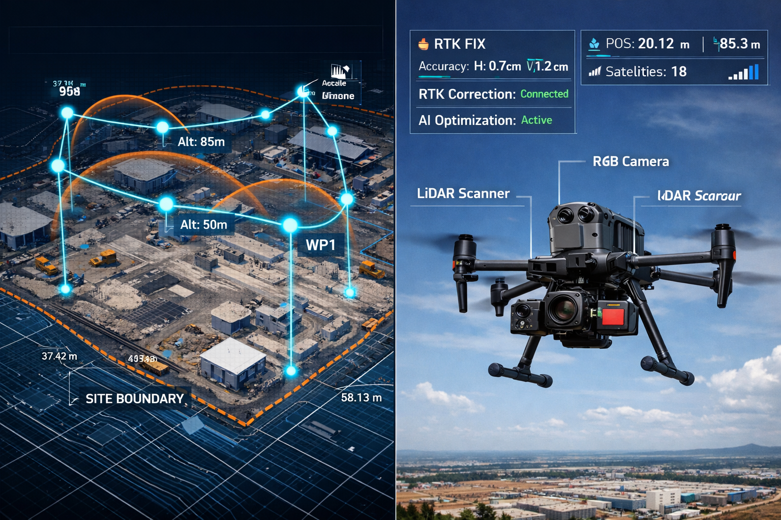
Real-Time Kinematic (RTK) and Post-Processed Kinematic (PPK) GNSS Systems provide the foundation for centimeter-level positioning. RTK systems receive correction signals from ground-based reference stations in real-time, while PPK systems apply corrections during post-processing[2][3]. Both methods achieve horizontal accuracy of ±2-3 centimeters and vertical accuracy of ±3-5 centimeters—precision that rivals traditional total station measurements.
Inertial Measurement Units (IMUs) work in conjunction with GNSS to maintain accurate positioning even during rapid movements or temporary signal loss. High-quality IMUs track the drone's orientation, acceleration, and angular velocity, ensuring that every image and sensor reading is precisely georeferenced[3].
Ground Control Points (GCPs) have traditionally been essential for achieving survey-grade accuracy. However, 2026 workflows demonstrate that RTK/PPK-equipped drones require significantly fewer GCPs without sacrificing precision[3]. This advancement is particularly valuable for:
- Remote locations where establishing GCPs is difficult
- Linear infrastructure projects (pipelines, highways, railways)
- Emergency response mapping where time is critical
- Large-area surveys where GCP establishment is cost-prohibitive
Multi-sensor data fusion enhances accuracy by combining information from multiple sources. When RGB cameras, LiDAR scanners, and GNSS receivers work together with AI-powered validation algorithms, the system can detect and correct errors that might occur with any single sensor[3].
The Role of Artificial Intelligence in Autonomous Operations
Artificial intelligence transforms autonomous drones from remotely piloted aircraft into truly intelligent surveying platforms. AI algorithms now handle tasks that previously required constant human decision-making:
Predictive Flight Path Planning: Modern systems analyze terrain data, project requirements, and environmental conditions to automatically generate optimal flight paths[1]. The AI considers factors such as:
- Ground elevation variations
- Obstacle locations (buildings, trees, power lines)
- Required image overlap for photogrammetry
- Lighting conditions and sun angle
- Wind patterns and weather forecasts
- Battery life and return-to-home requirements
Real-Time Adaptive Behavior: During flight, autonomous drones continuously adjust altitude, speed, and camera angles based on terrain changes[2]. When surveying a hillside development, for example, the drone maintains consistent ground sampling distance by automatically increasing altitude over peaks and descending into valleys—all without manual intervention.
Intelligent Obstacle Avoidance: Advanced collision avoidance systems use multiple sensors (visual cameras, infrared, ultrasonic) combined with AI processing to detect and avoid obstacles in real-time[2]. This capability is essential for safe autonomous operations, particularly in complex environments like construction sites or urban areas.
Automated Data Validation: AI algorithms analyze captured data during flight to ensure quality and completeness. If the system detects gaps in coverage, insufficient overlap, or image quality issues, it can automatically adjust the flight plan or recapture problematic areas[3]—eliminating the costly discovery of data gaps during post-processing.
Predictive Flight Paths and Multi-Sensor Integration for Large Property Surveys
Single-Flight Capture of Extensive Properties
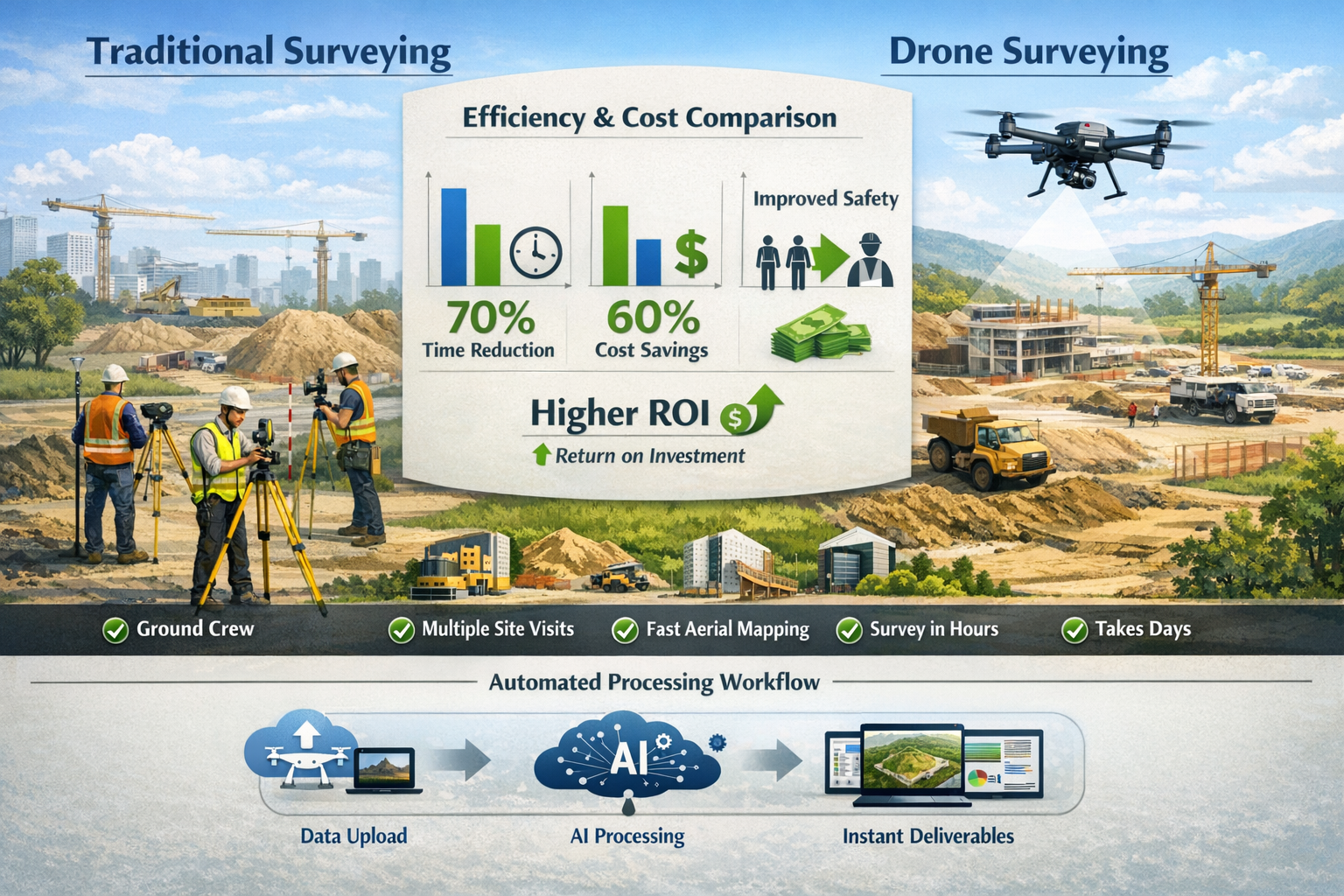
One of the most significant advantages of autonomous drones in land surveying is their ability to capture comprehensive data for large properties in a single mission. What previously required multiple site visits, crew rotations, and days or weeks of fieldwork can now be accomplished in hours[1][3].
Consider a typical 500-acre mixed-use development project. Traditional surveying approaches would require:
- Multiple survey teams working over several days
- Establishment of numerous control points
- Coordination with construction activities
- Repeated site access and setup time
- Separate surveys for different project phases
An autonomous drone system completes the same survey in a fundamentally different way:
| Traditional Surveying | Autonomous Drone Surveying |
|---|---|
| 5-10 days of fieldwork | 4-6 hours of flight time |
| 3-5 person survey crew | 1-2 operators for setup/monitoring |
| 20-30 ground control points | 5-8 control points with RTK/PPK |
| Multiple site mobilizations | Single mobilization |
| Weather delays impact entire crew | Flexible rescheduling with minimal cost |
| Limited data capture (specific points) | Comprehensive coverage (every square meter) |
The efficiency gains extend beyond time savings. A single autonomous flight produces complete spatial data for the entire property, enabling analyses that weren't practical with traditional point-based surveying. Property developers can extract volumetric calculations, create detailed contour maps, identify drainage patterns, and plan infrastructure—all from the same dataset[4].
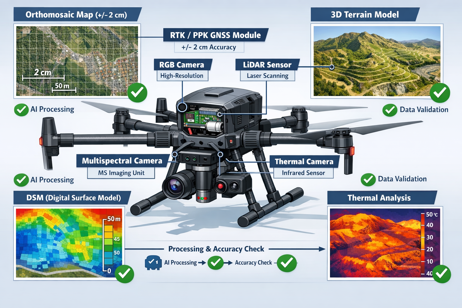
Multi-Sensor Platforms: Comprehensive Data in One Pass
Modern autonomous surveying drones integrate multiple sensor types to capture diverse geospatial information simultaneously[3]. This multi-sensor approach delivers comprehensive intelligence that would traditionally require separate surveys with different equipment:
📷 High-Resolution RGB Cameras capture detailed visual imagery for:
- Orthomosaic map generation
- Visual site documentation
- Feature identification and mapping
- Progress monitoring and change detection
🔦 LiDAR (Light Detection and Ranging) Systems have become the standard for topographic surveys in 2026[3]. LiDAR offers unique advantages:
- Penetrates vegetation to capture ground surface
- Operates effectively in low-light conditions
- Provides direct 3D point cloud data
- Delivers consistent accuracy across varying terrain
The cost of drone-mounted LiDAR systems has decreased dramatically, making this technology accessible for routine surveying applications. Modern LiDAR sensors provide faster pulse repetition rates, better IMU integration, and accurate data even under dense canopies[3]—ideal for forestry surveys, utility corridor mapping, and mining exploration.
🌡️ Thermal Imaging Sensors detect temperature variations useful for:
- Identifying moisture intrusion in structures
- Locating underground utilities
- Assessing roof condition and insulation
- Detecting heat loss in buildings
🌿 Multispectral Cameras capture data beyond visible light, valuable for:
- Vegetation health assessment
- Land use classification
- Environmental monitoring
- Agricultural applications
The integration of these sensors on a single autonomous platform means that property developers receive comprehensive site intelligence from one survey mission[3]. For example, a commercial development project might simultaneously obtain:
- Accurate topographic data (LiDAR)
- High-resolution site imagery (RGB)
- Vegetation health assessment (multispectral)
- Existing building condition analysis (thermal)
This comprehensive approach supports better decision-making throughout the project lifecycle, from initial site assessment through construction surveying and final as-built documentation.
Cloud-Based Processing and Rapid Deliverable Generation
The autonomous surveying workflow extends beyond data capture to include automated processing and deliverable generation. Modern cloud-based platforms receive raw survey data directly from the drone and apply sophisticated processing algorithms without manual intervention[2].
The typical workflow proceeds as follows:
- Automatic Data Upload: Upon landing, the drone automatically transfers captured data to cloud storage via WiFi or cellular connection
- AI-Powered Processing: Cloud platforms apply photogrammetry algorithms, LiDAR processing, and AI-based feature extraction
- Quality Control: Automated validation checks ensure data completeness and accuracy standards
- Deliverable Generation: The system produces standard surveying outputs (orthomosaics, DEMs, DSMs, contour maps, 3D models)
- Client Access: Processed data becomes available through web-based portals, typically within 24-48 hours
This automation significantly reduces turnaround time compared to traditional workflows where surveyors manually process data using desktop software[2]. For time-sensitive projects, rapid deliverable generation enables faster decision-making and project progression.
Advanced platforms also incorporate AI-assisted feature extraction and change detection[3]. The system can automatically identify and classify:
- Buildings and structures
- Roads and paved surfaces
- Vegetation types and boundaries
- Stockpiles and excavations
- Utility infrastructure
- Defects or anomalies
These AI capabilities automate processes that previously required days or weeks of manual digitizing and interpretation[3], further reducing the time from survey to actionable intelligence.
Safety, Cost Savings, and AI Integration Benefits for Property Developers
Enhanced Safety Through Reduced Human Exposure
Safety represents one of the most compelling advantages of autonomous drones in land surveying. Traditional surveying methods require personnel to access every measurement point, which often means exposure to hazardous conditions:
- ⚠️ Active construction sites with heavy equipment
- ⚠️ Unstable slopes and steep terrain
- ⚠️ Highway corridors with high-speed traffic
- ⚠️ Mining operations with blast zones
- ⚠️ Contaminated sites with environmental hazards
- ⚠️ Extreme weather conditions
Autonomous drone systems eliminate or dramatically reduce human exposure to these risks[2]. A single operator can safely launch, monitor, and recover the drone from a secure location while the aircraft autonomously navigates hazardous areas. This safety improvement has particular significance for:
Construction Site Monitoring: Regular progress surveys can occur without interrupting work or exposing surveyors to active construction zones. The drone operates above the work area, capturing comprehensive data while workers continue their tasks below[4].
Mining and Quarry Surveys: Stockpile measurements, pit surveys, and highwall inspections proceed without personnel entering unstable or dangerous areas. This capability has made autonomous drones the preferred method for mining surveying applications[3].
Infrastructure Corridor Mapping: Highway expansions, railway projects, and utility corridors can be surveyed without lane closures or traffic control measures, eliminating the risk of vehicle-related incidents.
Emergency Response: Following natural disasters or structural failures, autonomous drones can assess damage and create accurate site maps without exposing personnel to unstable structures or hazardous conditions.
The safety benefits extend beyond individual projects to create long-term organizational value. Reduced incident rates lower insurance costs, improve worker morale, and demonstrate corporate responsibility—factors that increasingly influence project awards and client relationships.
Quantifiable Cost Savings and Return on Investment
The economic case for autonomous drones in land surveying centers on substantial cost reductions across multiple dimensions[2][5]:
Labor Cost Reduction: Traditional surveying requires multi-person crews working extended periods in the field. Autonomous drone operations typically require only 1-2 personnel for setup and monitoring, with the drone handling the actual data capture autonomously. For a typical large-property survey:
- Traditional approach: 3-person crew × 8 days × $500/day = $12,000 labor cost
- Autonomous drone: 2-person crew × 1 day × $500/day = $1,000 labor cost
- Savings: $11,000 per project (92% reduction)
Equipment and Mobilization Savings: Ground-based surveying requires transporting total stations, GPS receivers, targets, and support equipment to the site multiple times. Autonomous drone systems are compact and require single mobilization, reducing vehicle costs, fuel expenses, and equipment wear.
Reduced Ground Control Point Requirements: Traditional aerial surveys required extensive GCP networks to achieve accuracy. RTK/PPK-equipped autonomous drones achieve survey-grade precision with 70-80% fewer control points[3], saving both establishment time and ongoing maintenance costs.
Faster Project Timelines: Time is money in development projects. Completing surveys in hours rather than days or weeks accelerates project schedules, enabling:
- Earlier design work initiation
- Faster permit submissions
- Reduced financing costs (shorter project duration)
- Earlier revenue generation from completed projects
Comprehensive Data Value: Single flights capture complete site coverage rather than discrete measurement points. This comprehensive data supports multiple uses without additional surveys:
- Initial site assessment
- Design development
- Construction planning
- Progress monitoring
- As-built documentation
- Marketing and visualization
For property developers managing multiple projects, the ROI calculation becomes even more compelling. A drone system that costs $50,000-$100,000 (including RTK/PPK capability and processing software) typically pays for itself within 5-10 large projects through labor savings alone, with additional value from improved safety, faster timelines, and enhanced data quality[5].
AI Integration for Property Development Applications
Artificial intelligence extends the value of autonomous drone surveying beyond basic mapping to deliver actionable intelligence specifically valuable for property development:
Automated Volumetric Calculations: AI algorithms automatically calculate cut/fill volumes, stockpile quantities, and earthwork requirements from survey data[4]. For grading contractors and site developers, this means:
- Instant volume calculations without manual surface modeling
- Automated change detection comparing multiple survey dates
- Accurate material quantity estimates for bidding and planning
- Progress tracking against design specifications
Intelligent Feature Extraction: AI-powered systems automatically identify and classify site features[3], creating detailed inventories without manual digitizing:
- Existing structures and buildings
- Vegetation types and tree locations
- Utility infrastructure (visible elements)
- Drainage features and water bodies
- Access roads and paved areas
Predictive Analytics for Site Planning: Advanced AI applications analyze topographic data to optimize site layouts based on:
- Natural drainage patterns (minimizing grading costs)
- Solar exposure (optimizing building orientation)
- View corridors (maximizing property values)
- Access routes (minimizing infrastructure costs)
Automated Defect Detection: For existing structures, AI algorithms identify potential issues[3]:
- Roof damage or deterioration
- Structural deformation
- Moisture intrusion (thermal analysis)
- Vegetation encroachment
These AI capabilities transform survey data from static documentation into dynamic decision support tools. Property developers can explore multiple scenarios, optimize designs, and identify issues early—when changes are least expensive to implement.
Regulatory Framework and BVLOS Operations in 2026
The regulatory environment for autonomous drone operations has matured significantly by 2026, particularly regarding Beyond Visual Line of Sight (BVLOS) operations[3]. Key developments include:
Streamlined BVLOS Approvals: Regulatory authorities in the US and globally have established clear pathways for commercial BVLOS operations, recognizing the safety and economic benefits of autonomous systems. Approved operations now include:
- Linear infrastructure surveys (pipelines, transmission lines, railways)
- Large-area mapping projects
- Routine construction site monitoring
- Agricultural and forestry applications
Remote ID Integration: Mandatory Remote ID systems provide real-time identification and location information for all drones, enabling safe integration with manned aviation and other airspace users[3]. This infrastructure supports expanded autonomous operations while maintaining airspace safety.
Drone-in-a-Box Systems: Permanently installed autonomous platforms that operate without on-site personnel have become increasingly common[3]. These systems enable:
- Scheduled routine surveys (daily construction progress monitoring)
- Rapid emergency response (incident documentation)
- Continuous monitoring applications (security, environmental)
Standardized Operating Procedures: Industry organizations and regulatory bodies have developed standardized procedures for autonomous surveying operations, providing clear guidance on:
- Pre-flight planning and risk assessment
- Autonomous flight monitoring requirements
- Emergency response protocols
- Data security and privacy protection
For property developers and surveying professionals, this regulatory maturity means greater operational flexibility and confidence in deploying autonomous systems for routine applications. Understanding these frameworks is essential for maximizing the benefits while maintaining compliance with applicable regulations.
Integration with Traditional Surveying Workflows
While autonomous drones offer remarkable capabilities, they function most effectively when integrated with traditional surveying methods rather than completely replacing them. Professional surveyors in 2026 employ hybrid approaches that leverage the strengths of each technology:
Ground Control and Verification: Even with RTK/PPK capability, establishing some ground control points ensures independent verification of drone-derived data. Professional workflows typically include:
- Strategic GCP placement at project boundaries and key features
- Independent check points for accuracy validation
- Monumented control for long-term project reference
Detailed Feature Surveys: While drones excel at capturing overall site conditions, traditional total station surveys remain valuable for:
- Precise location of property corners and boundary surveys
- Detailed building layouts and as-built documentation
- Underground utility locations (requiring ground-based detection)
- Features obscured by dense vegetation or structures
Professional Judgment and Interpretation: Autonomous systems generate vast amounts of data, but professional surveyors provide essential interpretation:
- Evaluating data quality and identifying potential errors
- Determining appropriate survey methods for specific applications
- Certifying survey accuracy and professional compliance
- Providing expert testimony when required
This integrated approach delivers optimal results: the efficiency and comprehensive coverage of autonomous drones combined with the precision and professional expertise of traditional surveying. Property developers benefit from faster project timelines without sacrificing the accuracy and professional certification required for regulatory approvals and construction planning.
Industry Applications and Real-World Implementation
Construction and Development Projects
The construction industry has rapidly adopted autonomous drone surveying for multiple applications throughout the project lifecycle[4][5]:
Site Assessment and Due Diligence: Before purchasing development property, autonomous drones provide comprehensive site documentation including:
- Accurate topographic mapping
- Existing structure inventory and condition
- Vegetation assessment
- Access and utility evaluation
- Environmental feature identification
This information supports informed purchase decisions and accurate project feasibility analysis, similar to how detailed property inspections inform residential purchase decisions.
Design Development: Survey data feeds directly into design software, enabling architects and engineers to:
- Create accurate base maps for design work
- Develop optimized grading plans
- Plan infrastructure routing
- Visualize proposed developments in context
Construction Progress Monitoring: Regular autonomous surveys track construction progress with minimal disruption to ongoing work[4]. Weekly or monthly flights document:
- Earthwork quantities and grading progress
- Foundation and structural completion
- Material stockpile inventory
- Site access and logistics
As-Built Documentation: Final surveys capture completed conditions for record documentation, warranty purposes, and facility management. The comprehensive data supports future renovations, expansions, or maintenance planning.
Mining and Aggregate Operations
Mining operations have embraced autonomous drones as the standard method for stockpile measurement and pit surveys[3]. The technology addresses unique challenges in mining environments:
Stockpile Volumetrics: Accurate material quantity measurement is essential for inventory management, sales verification, and financial reporting. Autonomous drones provide:
- Monthly or weekly stockpile surveys without production interruption
- Accurate volume calculations (typically ±2-3% accuracy)
- Historical tracking of inventory changes
- Automated reporting and documentation
Pit Progression Surveys: Regular surveys document mining progress, support blast planning, and ensure regulatory compliance:
- Highwall stability monitoring
- Excavation volume tracking
- Haul road condition assessment
- Reclamation planning and documentation
Safety in Hazardous Environments: Mining presents numerous hazards—unstable slopes, heavy equipment, blast zones, and contaminated areas. Autonomous drones eliminate human exposure while providing comprehensive site documentation.
Infrastructure and Corridor Mapping
Linear infrastructure projects benefit particularly from autonomous drone capabilities[3]:
Highway and Railway Projects: Corridor surveys for transportation infrastructure require:
- Long, narrow survey areas (difficult for traditional methods)
- Minimal traffic disruption
- Coordination with active operations
- Regular progress monitoring
Autonomous drones excel at these applications, surveying miles of corridor in single flights while maintaining centimeter-level accuracy throughout.
Utility Corridor Management: Electric transmission lines, pipelines, and communication networks require regular inspection and vegetation management. Autonomous systems provide:
- Comprehensive corridor documentation
- Vegetation encroachment identification
- Structure condition assessment
- Right-of-way compliance monitoring
Bridge and Structure Inspection: While not traditional land surveying, autonomous drones equipped with high-resolution cameras and AI-powered defect detection provide detailed structure inspection without scaffolding, lane closures, or rope access—significantly reducing inspection costs and safety risks.
Agricultural and Environmental Applications
Beyond traditional surveying, autonomous drones serve agricultural and environmental monitoring needs:
Precision Agriculture: Multispectral sensors identify crop health variations, enabling targeted interventions:
- Variable rate fertilizer application
- Irrigation management
- Pest and disease detection
- Yield prediction
Environmental Monitoring: Regular autonomous surveys document environmental conditions:
- Wetland mapping and monitoring
- Erosion assessment
- Habitat documentation
- Restoration project tracking
Forestry Management: LiDAR-equipped drones penetrate forest canopies to provide:
- Accurate ground surface models
- Tree height and density measurements
- Timber volume estimates
- Forest health assessment
These applications demonstrate the versatility of autonomous surveying platforms beyond traditional land development, providing value across diverse industries and applications.
Urban Planning and Smart City Development
Municipal governments and urban planners increasingly leverage autonomous drone data for city management:
3D City Modeling: Comprehensive aerial surveys create detailed 3D models of urban areas, supporting:
- Urban planning and development review
- Infrastructure planning
- Emergency response planning
- Public engagement and visualization
Infrastructure Asset Management: Regular surveys document public infrastructure condition:
- Road surface assessment
- Drainage system mapping
- Park and facility inventory
- Public space utilization analysis
Change Detection and Compliance: Automated comparison of multi-temporal surveys identifies:
- Unauthorized construction or modifications
- Land use changes
- Environmental compliance
- Development progress
The surveying technology advances represented by autonomous drones enable municipal governments to maintain current, comprehensive spatial data that supports better planning decisions and more efficient public services.
Future Developments and Emerging Technologies
Enhanced Autonomy and Swarm Operations
The trajectory of autonomous drone development points toward even greater autonomy and coordination:
Fully Autonomous Operations: Future systems will require minimal human intervention beyond defining project requirements. The drone will autonomously:
- Analyze project specifications and generate optimal survey plans
- Execute missions without monitoring
- Validate data quality and identify gaps
- Refly problem areas automatically
- Process and deliver final products
Swarm Technology: Multiple drones working cooperatively will survey extremely large areas in dramatically reduced timeframes. Coordinated swarms offer:
- Parallel data capture across vast properties
- Redundant coverage for quality assurance
- Specialized sensor deployment (different drones carrying different sensors)
- Rapid response for time-critical applications
Advanced AI and Machine Learning Applications
Artificial intelligence capabilities will continue expanding:
Predictive Maintenance: AI analysis of drone sensor data will predict equipment failures before they occur, ensuring maximum system reliability and minimizing downtime.
Intelligent Data Fusion: Advanced algorithms will combine data from multiple sensors, multiple flights, and multiple time periods to create comprehensive site intelligence that reveals patterns and trends invisible in individual datasets.
Automated Design Integration: AI systems will automatically incorporate survey data into design software, generating preliminary site plans, grading designs, and infrastructure layouts based on project requirements and site conditions.
Regulatory Evolution and Expanded Operations
Regulatory frameworks will continue evolving to support expanded autonomous operations:
Urban BVLOS Operations: Approval frameworks for autonomous flights over populated areas will enable routine urban surveying applications without visual observers.
Automated Traffic Management: Integration with unmanned traffic management (UTM) systems will enable safe, coordinated operations with multiple drones sharing airspace.
International Harmonization: Standardized international regulations will facilitate cross-border operations and global deployment of autonomous surveying systems.
These developments will further enhance the value proposition of autonomous drones in land surveying, making the technology accessible to smaller firms and expanding applications across diverse industries.
Conclusion
Autonomous drones in land surveying: achieving centimeter-level accuracy with minimal human intervention represents a fundamental transformation in how surveying professionals approach their work. The technology delivers survey-grade precision that meets or exceeds traditional methods while offering substantial advantages in efficiency, safety, and cost-effectiveness.
For property developers, construction managers, and surveying professionals in 2026, autonomous drone systems provide:
✅ Survey-grade accuracy through RTK/PPK GNSS integration
✅ Comprehensive site coverage in single flights capturing hundreds of acres
✅ Multi-sensor intelligence combining RGB, LiDAR, thermal, and multispectral data
✅ AI-powered automation minimizing human intervention while maximizing quality
✅ Substantial cost savings through reduced labor and faster project timelines
✅ Enhanced safety by eliminating human exposure to hazardous conditions
✅ Rapid deliverables through cloud-based automated processing
The integration of predictive flight paths, multi-sensor platforms, and artificial intelligence creates surveying systems that operate with unprecedented autonomy while delivering professional-grade results. These capabilities translate directly into business value: faster project progression, reduced costs, improved safety, and comprehensive data supporting better decision-making throughout the development process.
Actionable Next Steps
For organizations considering autonomous drone adoption:
-
Assess Current Surveying Needs: Evaluate typical project requirements, current costs, and timeline constraints to identify applications where autonomous drones offer maximum value
-
Develop Technical Requirements: Determine necessary accuracy levels, sensor types, and processing capabilities based on specific applications—whether topographic mapping, construction monitoring, or specialized assessments
-
Evaluate System Options: Research available platforms considering RTK/PPK capability, sensor integration, flight time, and automation features matching identified requirements
-
Plan Training and Integration: Develop training programs for operators and establish workflows integrating autonomous drone data with existing surveying and design processes
-
Start with Pilot Projects: Begin with limited deployments on suitable projects to develop operational experience, validate accuracy, and demonstrate value before full-scale implementation
-
Establish Quality Control Procedures: Develop protocols for data validation, accuracy verification, and professional certification ensuring autonomous survey data meets required standards
-
Monitor Regulatory Developments: Stay informed about evolving regulations, particularly regarding BVLOS operations and autonomous system approvals in your operational area
The surveying industry's transformation through autonomous drone technology is not a distant future prospect—it's the current reality in 2026. Organizations that effectively integrate these capabilities position themselves for competitive advantage through superior efficiency, enhanced safety, and comprehensive data intelligence. Whether managing large development projects, conducting routine construction monitoring, or providing professional surveying services, autonomous drones deliver measurable value that continues expanding as technology and regulatory frameworks evolve.
The question is no longer whether to adopt autonomous drone surveying, but how quickly organizations can effectively integrate this transformative technology into their operational workflows. Those who move decisively will reap the benefits of reduced costs, improved safety, and enhanced capabilities that define professional surveying excellence in the modern era.
References
[1] Future Land Surveying 2026 – https://haller-blanchard.com/future-land-surveying-2026/
[2] Self Flying Uavs For Survey Mapping Are Redefining Aerial Intelligence – https://www.dronitech.com/self-flying-uavs-for-survey-mapping-are-redefining-aerial-intelligence/
[3] How Drones Are Transforming Surveying Mapping And Inspection In 2026 – https://www.uavsphere.com/post/how-drones-are-transforming-surveying-mapping-and-inspection-in-2026
[4] Drones In Construction – https://uavcoach.com/drones-in-construction/
[5] Zenatech S Drone As A Service Expands Builder Services Capability Delivering Drone Driven Speed And Precision To Surveying For Homebuilders 1035808701 – https://markets.businessinsider.com/news/currencies/zenatech-s-drone-as-a-service-expands-builder-services-capability-delivering-drone-driven-speed-and-precision-to-surveying-for-homebuilders-1035808701