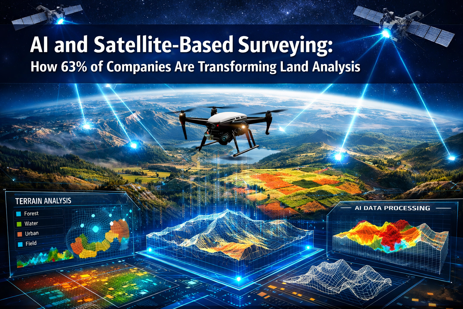
The surveying industry stands at a technological crossroads in 2026, where artificial intelligence and satellite-based systems are fundamentally reshaping how companies analyze land. While traditional surveying methods have served the industry for decades, a remarkable shift is underway: 63% of companies are now actively exploring or implementing AI and satellite-based surveying solutions to enhance accuracy, reduce costs, and accelerate project timelines. This transformation represents more than just technological advancement—it signals a complete reimagining of how professionals approach land analysis, from initial data collection through final deliverables.
The convergence of AI algorithms with satellite positioning technology has created unprecedented opportunities for surveying professionals. What once required multiple site visits, extensive manual calculations, and weeks of processing time can now be accomplished in hours with autonomous systems that instantly classify terrain, identify markers, and generate preliminary surface models.[3] This article explores how AI and satellite-based surveying is transforming land analysis across the architecture, engineering, and construction (AEC) sector, examining the drivers behind adoption, practical applications, and the evolving role of surveying professionals in this new landscape.
Key Takeaways
🎯 Rapid Industry Transformation: Despite only 27% of AEC companies currently using AI, 94% of adopters plan to increase usage in 2026, indicating explosive growth ahead.[6]
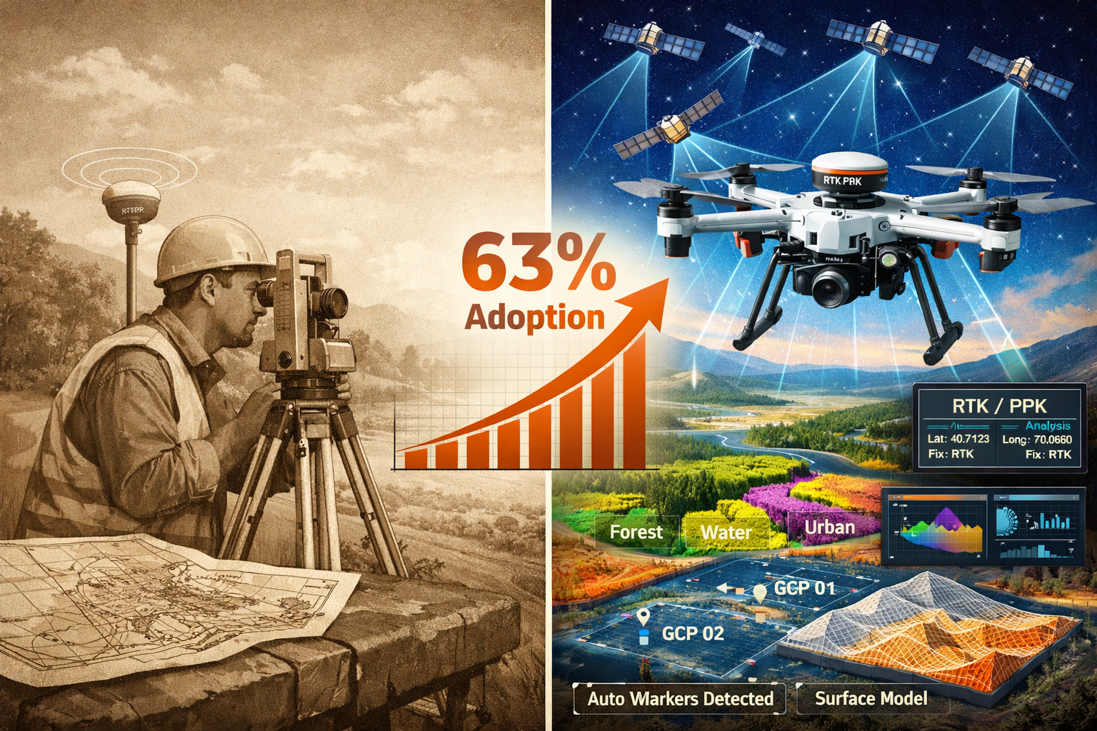
📊 Addressing Critical Labor Shortages: The surveying workforce declined from 56,200 to 47,770 professionals between 2010 and 2020, making automation essential for meeting industry demands.[2]
🚁 Autonomous Systems Revolutionizing Efficiency: AI-enabled drones can now survey hundreds of acres in a single flight with instant data processing, dramatically reducing operational costs.[1]
⚡ Real-Time Precision Improvements: RTK and PPK satellite positioning systems significantly enhance data accuracy, enabling more reliable land analysis.[4]
👨💼 Human Expertise Remains Critical: Survey professionals continue to play essential roles in ensuring data quality, particularly as GNSS jamming and spoofing risks increase.[2]
Understanding AI and Satellite-Based Surveying Technology
The Foundation of Modern Surveying Systems
AI and satellite-based surveying represents the integration of multiple advanced technologies working in concert. At its core, this approach combines Global Navigation Satellite Systems (GNSS) for precise positioning with artificial intelligence algorithms that process, analyze, and interpret collected data. The satellite component provides the spatial reference framework, while AI handles the increasingly complex task of transforming raw measurements into actionable insights.
Modern satellite positioning has evolved significantly beyond basic GPS capabilities. Real-time kinematics (RTK) and post-processing kinematic (PPK) positioning technologies now deliver centimeter-level accuracy by correcting satellite signal errors in real-time or during post-processing.[4] These systems receive signals from multiple satellite constellations simultaneously, including GPS, GLONASS, Galileo, and BeiDou, creating redundancy and improving reliability across diverse environmental conditions.
The AI component brings intelligence to data collection and processing. Machine learning algorithms trained on millions of survey datasets can now:
- Automatically classify terrain types based on visual and sensor data
- Identify ground control points and survey markers without human intervention
- Flag anomalies and potential errors during data collection
- Generate preliminary surface models instantly upon data capture
- Predict optimal flight paths for drone-based surveys
This integration creates a feedback loop where AI systems continuously improve their accuracy based on new data, while satellite positioning ensures that every data point has precise spatial coordinates. For professionals conducting property condition assessments, this means more comprehensive data collection with fewer site visits.
How AI Processes Satellite Survey Data
The transformation from raw satellite and sensor data to usable survey deliverables involves several AI-powered stages. When a drone equipped with multiple sensors captures data over a survey area, the process unfolds as follows:
Stage 1: Data Acquisition and Georeferencing
Sensors capture imagery, LiDAR point clouds, and multispectral data while GNSS receivers record precise positioning for each measurement. AI algorithms immediately begin validating data quality, checking for gaps in coverage, and flagging potential issues.
Stage 2: Automated Classification
Machine learning models analyze the captured data to identify and classify features:
- Vegetation types and density
- Built structures and infrastructure
- Water bodies and drainage patterns
- Elevation changes and topographic features
- Surface materials and conditions
Stage 3: Feature Extraction and Modeling
AI systems extract specific features relevant to the survey purpose, whether that's identifying building structural elements for property assessments or mapping underground utilities for construction planning.
Stage 4: Quality Control and Validation
Automated quality checks compare measurements against expected parameters, historical data, and industry standards. The system flags discrepancies for human review, ensuring accuracy before final deliverables are generated.
This automated workflow represents a fundamental shift from traditional surveying, where professionals manually processed data at each stage. The efficiency gains are substantial—what previously required days or weeks of office work now happens in hours, allowing surveyors to focus on interpretation and decision-making rather than data processing.
The Business Case: Why 63% of Companies Are Adopting AI and Satellite-Based Surveying
Addressing the Surveying Labor Shortage Crisis
The surveying profession faces a demographic crisis that makes technological adoption not just advantageous but essential for industry survival. The number of surveyors in the United States declined from 56,200 in 2010 to 47,770 in 2020—a 15% reduction during a period when infrastructure needs and development projects increased.[2] This labor shortage creates a compelling business case for AI and satellite-based surveying solutions that can multiply the productivity of remaining professionals.
Several factors contribute to this workforce decline:
- Aging workforce: Many experienced surveyors are reaching retirement age
- Limited new entrants: Fewer young professionals are entering the field
- Increased project complexity: Modern developments require more sophisticated analysis
- Regulatory demands: Stricter accuracy requirements increase workload
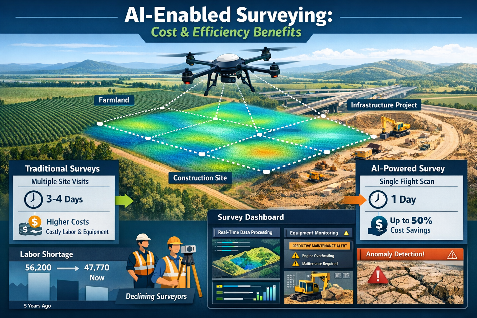
Companies adopting AI-powered surveying systems can accomplish more with smaller teams. A single surveyor equipped with autonomous drone technology and AI processing capabilities can now complete surveys that previously required three to four professionals working over several days. This productivity multiplier makes the technology investment economically viable even for smaller firms that previously couldn't justify advanced equipment purchases.[1]
The labor shortage particularly impacts specialized surveying services like construction surveying and data analysis, where expertise is concentrated among senior professionals. AI systems can capture institutional knowledge through machine learning, preserving methodologies and best practices even as experienced surveyors retire.
Cost Efficiency and Operational Benefits
The financial advantages of AI and satellite-based surveying extend far beyond labor cost savings. AI-enabled UAVs can survey hundreds of acres in a single flight with instant data processing, dramatically reducing operational expenses across multiple categories.[1]
| Cost Category | Traditional Surveying | AI-Satellite Surveying | Savings |
|---|---|---|---|
| Field Time | 3-5 days for 100 acres | 2-4 hours for 100 acres | 85-90% |
| Personnel Required | 3-4 surveyors | 1 surveyor + 1 operator | 50-75% |
| Equipment Mobilization | Multiple trips, heavy equipment | Single deployment, portable systems | 60-80% |
| Data Processing | 5-10 days manual work | 4-8 hours automated | 90-95% |
| Revision Cycles | Requires field revisit | Remote analysis possible | 70-85% |
Beyond direct cost reductions, AI and satellite-based surveying delivers operational benefits that improve project outcomes:
Enhanced Safety: Drones can survey hazardous areas, steep slopes, and unstable structures without exposing personnel to risk. This is particularly valuable for specific defect surveys on damaged buildings or infrastructure.
Improved Client Service: Faster turnaround times and more comprehensive data allow companies to accept more projects and deliver results when clients need them most, such as during time-sensitive property transactions.
Competitive Differentiation: Firms offering AI-enhanced surveying can provide capabilities that traditional competitors cannot match, winning contracts based on technical superiority.
Scalability: Technology-enabled workflows allow companies to scale operations without proportionally increasing headcount, making growth more sustainable and profitable.
Infrastructure Maintenance Demands Driving Adoption
The condition of existing infrastructure creates urgent demand for efficient surveying capabilities. Currently, 39% of roads in the United States are in poor condition, representing a massive assessment and maintenance challenge that traditional surveying methods cannot adequately address.[2] AI and satellite-based surveying provides the speed and scale necessary to evaluate infrastructure conditions across entire regions.
Government agencies and private infrastructure owners face several challenges:
- Asset inventory: Many organizations lack complete records of infrastructure extent and condition
- Prioritization: Limited budgets require data-driven decisions about which assets need immediate attention
- Monitoring: Infrastructure degrades continuously, requiring regular reassessment
- Documentation: Regulatory compliance demands detailed condition records
AI-powered surveying addresses these challenges through capabilities like:
🔍 Automated Condition Assessment: Machine learning algorithms trained to recognize pavement distress, structural defects, and deterioration patterns can evaluate thousands of miles of roads or hundreds of structures in the time traditional methods assess a handful.
📊 Predictive Analytics: AI systems analyze historical condition data to predict future deterioration, enabling proactive maintenance scheduling that prevents catastrophic failures.
🗺️ Comprehensive Coverage: Satellite and drone-based systems can survey entire infrastructure networks, creating complete inventories that support strategic planning.
This capability extends beyond roads to bridges, railways, water systems, and electrical grids—all facing similar assessment challenges. For professionals conducting monitoring surveys, AI tools provide the consistency and frequency needed to track infrastructure changes over time.
Current State of AI Adoption in the Surveying Industry
Adoption Statistics and Growth Projections
The surveying and broader AEC sector is experiencing a technology transition period characterized by cautious but accelerating AI adoption. As of December 2025, only 27% of architecture, engineering, and construction companies currently use AI—a surprisingly low figure given the technology's potential.[6] However, this statistic masks a critical detail: 94% of companies already using AI plan to increase their usage in 2026, indicating that early adopters are experiencing positive results that justify expansion.[6]
This adoption pattern follows a classic technology diffusion curve:
Early Adopters (Current 27%): Large firms with dedicated technology budgets and specialized projects that justify advanced capabilities. These organizations are proving the business case and developing best practices.
Early Majority (Expected 2026-2027): Mid-size companies observing successful implementations and facing competitive pressure to match capabilities. Cost reductions in technology are making entry more accessible.
Late Majority (Expected 2028-2030): Smaller firms and specialized practices adopting mature, standardized solutions as they become industry expectations rather than competitive advantages.
Laggards (Beyond 2030): Organizations with niche practices or unique constraints that delay adoption until technology becomes absolutely necessary for market participation.
The planned increase in usage among current adopters suggests that AI and satellite-based surveying has moved beyond experimental status. Companies are integrating these capabilities into standard workflows, training staff, and building client expectations around AI-enhanced deliverables.
Geographic variations in adoption exist, with urban markets and regions facing severe labor shortages showing higher implementation rates. Regulatory environments also influence adoption—jurisdictions that accept AI-processed survey data for permitting and compliance purposes see faster uptake than those requiring traditional methodologies.
Technologies Currently Deployed in 2026
AI and satellite-based surveying in 2026 encompasses a diverse technology ecosystem that continues evolving rapidly. The most widely deployed systems include:
Autonomous Drone Platforms
Modern surveying drones operate with minimal human intervention, using AI to plan optimal flight paths based on terrain, weather conditions, and survey objectives.[3] These systems automatically adjust altitude, camera angle, and sensor selection to capture the highest quality data. Multi-sensor arrays capture what previously required multiple site visits in a single comprehensive flight, particularly beneficial for large-scale agricultural, commercial, and development properties.
Real-Time Processing Systems
Cloud-based AI platforms now process survey data during collection rather than afterward. Field teams receive immediate feedback about coverage gaps, data quality issues, or anomalies, allowing them to address problems before leaving the site. This eliminates costly return visits and ensures complete datasets.
Predictive Maintenance Technologies
AI sensors monitor survey equipment performance in real-time, identifying potential failures before they occur.[1] These systems track calibration drift, component wear, and performance degradation, scheduling maintenance proactively rather than reactively. This extends equipment lifespan and prevents field failures that could compromise project schedules.
Integrated GNSS Systems
Advanced satellite positioning combines signals from multiple constellation systems with terrestrial correction networks. RTK and PPK processing delivers centimeter-level accuracy even in challenging environments with partial sky visibility.[4] Integration with AI algorithms allows systems to detect and compensate for positioning errors caused by multipath interference, atmospheric conditions, or signal degradation.
Machine Learning Classification Engines
Trained on millions of labeled survey images and point clouds, these AI systems instantly classify terrain features, identify structures, and extract relevant information. The technology now handles complex scenarios like distinguishing between vegetation types, identifying underground utility markers, or detecting subtle ground movement indicating structural instability.
For professionals working on building surveys, these integrated systems provide unprecedented detail about structural conditions, enabling more accurate assessments and recommendations.
Industry Segments Leading Adoption
AI and satellite-based surveying adoption varies significantly across industry segments, with certain sectors demonstrating clear leadership:
Infrastructure and Transportation ⭐⭐⭐⭐⭐
Government agencies and transportation departments lead adoption due to the massive scale of assets requiring assessment. The combination of labor shortages and deteriorating infrastructure creates perfect conditions for AI implementation. These organizations use satellite-based systems to monitor thousands of miles of roads, railways, and bridges with consistent methodology.
Commercial Development ⭐⭐⭐⭐
Large-scale developers have embraced AI surveying for site selection, feasibility studies, and construction monitoring. The technology's ability to rapidly assess multiple potential sites and track construction progress against plans delivers clear ROI. Integration with Building Information Modeling (BIM) workflows makes AI-generated survey data particularly valuable.
Agriculture and Natural Resources ⭐⭐⭐⭐
Precision agriculture relies heavily on satellite-based surveying for crop monitoring, irrigation planning, and yield optimization. AI analysis of multispectral imagery identifies plant health issues, soil variations, and drainage problems at scales impossible with ground-based methods.
Utilities and Energy ⭐⭐⭐⭐
Electric utilities, pipeline operators, and renewable energy developers use AI-powered surveying for route planning, right-of-way monitoring, and asset inspection. Drone-based systems can inspect transmission lines, solar installations, and wind turbines more safely and economically than traditional methods.
Residential Property Assessment ⭐⭐⭐
While adoption lags larger commercial applications, residential property professionals increasingly use AI surveying for property valuations and condition assessments. The technology provides detailed roof inspections, drainage analysis, and boundary verification without requiring extensive physical access.
Practical Applications Transforming Land Analysis
Automated Terrain Classification and Feature Detection
One of the most transformative applications of AI in satellite-based surveying is the automated classification of terrain and detection of features across surveyed landscapes. AI systems now instantly classify terrain, identify markers, flag anomalies, and generate preliminary surface models without manual data sorting.[3] This capability fundamentally changes the economics and timeline of land analysis projects.
Traditional terrain classification required surveyors to manually review imagery and point cloud data, categorizing each area based on visual characteristics and measurement data. This process was time-consuming, subjective, and prone to inconsistency between different analysts. AI-powered classification delivers:
Consistency: Machine learning models apply identical criteria across entire datasets, eliminating subjective variations in classification decisions.
Speed: Algorithms process gigabytes of survey data in minutes, classifying millions of data points faster than human analysts could review them.
Granularity: AI systems detect subtle variations in terrain characteristics that human observers might miss, identifying micro-topographic features relevant to drainage, stability, or ecological assessment.
Multi-dimensional Analysis: Beyond visual classification, AI correlates multiple data streams—elevation, spectral signatures, texture, and context—to make more informed classification decisions.
Practical applications include:
- Construction Site Analysis: Automatically identifying areas requiring excavation, fill, or special foundation treatment based on soil characteristics and topography
- Environmental Assessment: Detecting wetlands, sensitive habitats, and protected vegetation that might impact development approvals
- Infrastructure Planning: Identifying optimal routes for roads, utilities, or pipelines based on terrain characteristics and existing features
- Flood Risk Evaluation: Modeling water flow patterns and identifying flood-prone areas based on topographic analysis
For professionals conducting geographic information systems analysis, AI-classified terrain data provides a foundation for sophisticated spatial modeling and decision-making.
Autonomous Flight Planning and Data Collection
The integration of AI with drone-based surveying platforms has created truly autonomous data collection systems. Flight paths can now be planned using predictive modeling, with drones automatically adjusting altitude, angle, and sensor selection for optimal readings.[3] This automation transforms surveying from a manually intensive field operation into a supervised autonomous process.
Modern autonomous surveying workflows operate as follows:
Pre-Flight Planning
AI algorithms analyze the survey area using existing satellite imagery, topographic data, and project requirements. The system generates an optimal flight plan that:
- Maximizes coverage while minimizing flight time and battery changes
- Adjusts altitude to maintain consistent ground sample distance across varying terrain
- Positions the sun angle to minimize shadows and optimize imagery quality
- Identifies obstacles and plans safe navigation routes
- Schedules flights during optimal weather windows based on forecast data
Adaptive In-Flight Adjustments
During data collection, AI systems continuously monitor data quality and environmental conditions, making real-time adjustments:
- Increasing overlap in areas with complex features requiring additional detail
- Adjusting camera exposure for varying lighting conditions
- Modifying flight speed based on wind conditions to maintain stability
- Rerouting around unexpected obstacles or restricted airspace
- Prioritizing critical areas if battery limitations require abbreviated coverage
Quality Assurance During Collection
Rather than discovering data gaps or quality issues during post-processing, AI systems provide real-time feedback to operators. The system alerts when:
- Coverage gaps exist that require additional passes
- Image quality falls below acceptable thresholds
- GNSS positioning accuracy degrades requiring recalibration
- Environmental conditions (wind, precipitation) compromise data quality
This autonomous capability is particularly valuable for large-scale surveys where manual flight planning would be prohibitively time-consuming. A 500-acre development site that might require days of planning and multiple field visits can now be surveyed in a single automated session with confidence that data quality meets project requirements.
Multi-Sensor Integration and Comprehensive Data Capture
Perhaps the most significant advancement in AI and satellite-based surveying is the integration of multiple sensor types into single platforms that capture comprehensive datasets. Advanced drones now capture what previously required multiple site visits in a single, highly detailed flight, particularly beneficial for agricultural, commercial, and development-scale properties.[3]
Modern surveying platforms integrate:
RGB Cameras: High-resolution visual imagery for feature identification, documentation, and photogrammetric modeling.
LiDAR Sensors: Laser-based ranging that penetrates vegetation to capture bare-earth topography and detect subtle elevation changes invisible to cameras.
Multispectral Cameras: Sensors capturing light beyond human visual range, revealing vegetation health, moisture content, and material composition.
Thermal Imaging: Infrared sensors detecting temperature variations that indicate moisture intrusion, insulation defects, or equipment malfunctions.
GNSS Receivers: Multi-constellation satellite positioning providing precise georeferencing for all collected data.
AI algorithms fuse these diverse data streams into unified datasets where each measurement point contains:
- Precise 3D coordinates from GNSS and LiDAR
- Visual appearance from RGB imagery
- Spectral characteristics from multispectral sensors
- Thermal properties from infrared cameras
- Contextual classification from AI analysis
This comprehensive data capture enables applications impossible with single-sensor approaches:
Building Envelope Assessment: Combining thermal imaging with high-resolution photography to identify moisture intrusion, insulation gaps, and structural defects during building condition surveys.
Vegetation Management: Multispectral analysis identifies diseased or stressed plants requiring attention, while LiDAR measures canopy height and density for maintenance planning.
Infrastructure Monitoring: Thermal sensors detect overheating electrical components, while visual imagery documents physical condition and LiDAR measures structural deformation over time.
Archaeological Survey: LiDAR penetrates vegetation to reveal subtle ground features, while multispectral imaging identifies soil composition variations indicating buried structures.
The efficiency gains from single-pass multi-sensor collection are substantial. Projects that previously required separate visits for topographic survey, vegetation assessment, and thermal inspection can now be completed in one comprehensive data collection session, reducing costs by 60-80% while delivering more complete information.
The Evolving Role of Survey Professionals
From Data Collection to Data Validation and Interpretation
As AI and satellite-based surveying automates data collection and processing, the role of survey professionals is evolving from field technicians to data scientists and quality assurance specialists. Survey professionals remain essential for ensuring collected data is relevant, precise, and accurate—especially amid increased risks of GNSS jamming and spoofing.[2]
This evolution creates new professional responsibilities:
Data Quality Assurance
Rather than personally measuring every point, surveyors now validate that automated systems collect appropriate data to project specifications. This requires understanding:
- AI algorithm limitations and potential failure modes
- GNSS positioning accuracy factors and error sources
- Sensor calibration requirements and drift characteristics
- Environmental conditions affecting data quality
- Regulatory standards for survey accuracy and documentation
Contextual Interpretation
AI systems excel at pattern recognition and classification but lack the contextual understanding that experienced professionals bring. Surveyors add value by:
- Interpreting anomalies flagged by AI systems
- Recognizing features that algorithms might misclassify
- Understanding regulatory requirements and industry standards
- Applying professional judgment to ambiguous situations
- Communicating findings to non-technical stakeholders
System Oversight and Calibration
Automated surveying systems require professional oversight to maintain accuracy and reliability. Surveyors are responsible for:
- Verifying system calibration before critical surveys
- Establishing ground control networks for GNSS validation
- Monitoring equipment performance and scheduling maintenance
- Updating AI models with local knowledge and project-specific requirements
- Documenting methodology for regulatory compliance and professional liability
Client Consultation and Project Planning
As technical execution becomes automated, client interaction becomes a larger portion of professional work. Surveyors help clients:
- Define appropriate survey scope and accuracy requirements
- Understand capabilities and limitations of different technologies
- Interpret results and make informed decisions
- Plan follow-up investigations when initial surveys reveal issues
This shift parallels changes in other professions where automation handles routine tasks while humans focus on judgment, interpretation, and client relationships. For professionals conducting chartered surveyor work, this evolution emphasizes the importance of continuous education and adaptation to new technologies.
Addressing GNSS Security Concerns
The increasing reliance on satellite-based positioning creates new vulnerabilities that require professional vigilance. Data quality is critical, especially amid increased risks of GNSS jamming and spoofing.[2] These threats can compromise survey accuracy without obvious warning signs, making professional oversight essential.
GNSS Jamming occurs when radio frequency interference prevents receivers from detecting satellite signals. This can be:
- Unintentional (radio transmitters, electrical interference)
- Intentional (security measures, malicious disruption)
- Environmental (atmospheric conditions, terrain blocking)
GNSS Spoofing involves broadcasting false satellite signals that deceive receivers into calculating incorrect positions. This sophisticated attack can:
- Shift all measurements by consistent offsets (difficult to detect)
- Gradually drift positions over time (extremely subtle)
- Create inconsistent errors across survey areas (easier to identify)
Survey professionals protect against these threats through multiple strategies:
✅ Multi-Constellation Receivers: Using GNSS systems that receive signals from GPS, GLONASS, Galileo, and BeiDou simultaneously makes jamming and spoofing more difficult and easier to detect through cross-validation.
✅ Ground Control Networks: Establishing physical monuments with known coordinates allows verification of GNSS-derived positions, detecting systematic errors from jamming or spoofing.
✅ Redundant Positioning Methods: Combining GNSS with terrestrial surveying techniques (total stations, levels) provides independent verification of critical measurements.
✅ Statistical Analysis: AI algorithms can detect anomalous positioning patterns indicating interference, but professional judgment is required to distinguish genuine threats from benign environmental effects.
✅ Signal Authentication: Advanced receivers verify satellite signal authenticity, though this capability is not yet universal across surveying equipment.
The professional responsibility for data integrity cannot be delegated to automated systems. While AI can flag potential issues, experienced surveyors must investigate anomalies, implement verification procedures, and ultimately certify that survey results meet accuracy requirements despite potential GNSS vulnerabilities.
New Skills and Training Requirements
The transformation of surveying through AI and satellite technology creates new educational and training requirements for professionals. Traditional surveying education emphasized field techniques, instrumentation, and manual calculation methods. Modern practitioners need additional competencies:
Data Science Fundamentals
Understanding how AI algorithms process survey data, including:
- Machine learning concepts and limitations
- Statistical analysis and uncertainty quantification
- Data visualization and presentation techniques
- Database management and spatial analysis
Technology Integration
Operating and maintaining complex integrated systems:
- Multi-sensor platform configuration and calibration
- Cloud-based processing workflow management
- Software integration across survey, design, and analysis tools
- Cybersecurity awareness for protecting survey data
Quality Control Methodology
Developing and implementing validation procedures:
- Automated quality checking algorithms
- Statistical process control for survey operations
- Error budget analysis for complex measurement systems
- Documentation standards for AI-assisted surveys
Regulatory Compliance
Navigating evolving standards for technology-based surveying:
- Understanding which jurisdictions accept AI-processed survey data
- Documenting methodology to meet professional liability requirements
- Staying current with changing regulations and standards
- Communicating technology capabilities to regulatory authorities
Professional organizations and educational institutions are adapting to these requirements through:
- Continuing education programs focused on AI and automation
- Updated university curricula incorporating data science and technology
- Certification programs for specific surveying technologies
- Industry conferences showcasing emerging capabilities and best practices
The most successful surveying professionals in 2026 combine traditional surveying knowledge with technology fluency, understanding both the fundamental principles of spatial measurement and the capabilities and limitations of AI-powered tools that implement those principles at scale.
Implementation Considerations for Surveying Companies
Technology Investment and ROI Analysis
Companies considering AI and satellite-based surveying face significant investment decisions requiring careful return-on-investment analysis. While costs have decreased substantially as technologies mature, initial capital requirements remain substantial for comprehensive implementations.
Typical Investment Components:
| Category | Entry Level | Mid-Range | Advanced |
|---|---|---|---|
| Drone Platform | £3,000-£8,000 | £12,000-£25,000 | £35,000-£75,000+ |
| Sensors (LiDAR, multispectral) | £5,000-£15,000 | £20,000-£45,000 | £60,000-£150,000+ |
| GNSS Equipment | £8,000-£15,000 | £18,000-£35,000 | £40,000-£80,000+ |
| Processing Software | £2,000-£5,000/year | £8,000-£15,000/year | £20,000-£50,000+/year |
| Training & Certification | £3,000-£8,000 | £10,000-£20,000 | £25,000-£50,000+ |
| Total Initial Investment | £21,000-£51,000 | £68,000-£140,000 | £180,000-£405,000+ |
These investments must be justified through operational improvements and revenue growth. AI-enabled UAVs can survey hundreds of acres in a single flight with instant data processing, reducing operational costs significantly.[1] ROI calculations should consider:
Direct Cost Savings
- Reduced field time (typically 70-85% reduction for large sites)
- Lower labor requirements (50-75% fewer person-hours)
- Decreased equipment mobilization costs
- Faster project turnaround enabling higher project volume
Revenue Opportunities
- Ability to bid on larger, more complex projects
- Premium pricing for advanced capabilities and faster delivery
- New service offerings (monitoring, predictive analysis)
- Geographic expansion without proportional staff increases
Risk Reduction
- Improved safety reducing insurance costs and liability
- Higher accuracy reducing professional liability exposure
- Better documentation supporting defensible deliverables
- Equipment predictive maintenance preventing costly failures
Most surveying firms implementing comprehensive AI and satellite-based systems report ROI periods of 18-36 months, with larger firms serving high-volume markets achieving payback more quickly than smaller practices with specialized niches.
Integration with Existing Workflows and Systems
Successful AI and satellite-based surveying implementation requires thoughtful integration with existing business processes, software systems, and client deliverable formats. Technology adoption fails when new capabilities exist in isolation rather than enhancing established workflows.
Critical Integration Points:
Field-to-Office Workflow
Connecting autonomous data collection with office processing and deliverable production:
- Automated data transfer from field equipment to processing servers
- Quality control checkpoints before field crews demobilize
- Progress tracking visible to project managers and clients
- Standardized naming conventions and file organization
Software Ecosystem
Modern surveying practices use multiple specialized applications:
- CAD platforms for plan production and design coordination
- GIS systems for spatial analysis and database management
- Project management tools for scheduling and resource allocation
- Client portals for deliverable distribution and collaboration
AI-powered surveying systems must export data in formats compatible with these existing tools. Open data standards and API integrations enable seamless information flow without manual file conversion or reformatting.
Client Deliverable Standards
While AI systems generate sophisticated analytical products, clients often require traditional deliverable formats:
- Survey plans meeting regulatory plotting standards
- Legal descriptions for property boundaries
- Topographic maps with standard symbology
- As-built documentation matching original design drawings
Successful implementations maintain client-facing deliverable standards while leveraging AI capabilities for efficiency and enhanced analysis. For projects like stock condition surveys, this means combining AI-generated condition assessments with professional reports meeting industry expectations.
Quality Management Systems
Professional surveying practices maintain quality management procedures for accuracy verification, peer review, and documentation. AI-assisted surveys require updated procedures addressing:
- Validation of AI-generated classifications and measurements
- Documentation of algorithms and processing parameters
- Archiving of raw data for potential reprocessing
- Professional certification of AI-assisted deliverables
Regulatory Compliance and Professional Standards
The regulatory landscape for AI and satellite-based surveying continues evolving as jurisdictions develop standards for accepting technology-assisted survey data. Survey professionals must navigate varying requirements across different locations and project types.
Current Regulatory Environment:
Survey Accuracy Standards
Most jurisdictions maintain accuracy requirements for different survey types (boundary, topographic, construction, etc.) without specifying methodology. AI-assisted surveys must demonstrate compliance with these standards through:
- Documented calibration and validation procedures
- Ground control networks establishing reference accuracy
- Statistical analysis demonstrating compliance with accuracy tolerances
- Professional certification by licensed surveyors
Data Acceptance
Regulatory authorities vary in accepting AI-processed survey data:
- Progressive jurisdictions: Accept AI-assisted surveys with appropriate documentation and professional certification
- Conservative jurisdictions: Require traditional verification of AI-generated measurements
- Evolving jurisdictions: Developing standards and pilot programs for technology acceptance
Professional Licensing
Survey regulations typically require licensed professionals to take responsibility for survey accuracy and methodology. AI and satellite-based surveying doesn't eliminate this requirement—licensed surveyors remain legally responsible for:
- Selecting appropriate technology for project requirements
- Validating system accuracy and calibration
- Reviewing and certifying AI-generated results
- Documenting methodology and quality control procedures
Liability Considerations
Professional liability insurance for surveyors increasingly addresses technology-related risks:
- Coverage for errors in AI algorithm implementation
- Protection against GNSS positioning failures
- Liability for reliance on third-party processing services
- Cyber liability for data breaches or system compromises
Survey professionals implementing AI and satellite-based systems should:
- Consult with professional liability insurers about coverage
- Document technology capabilities and limitations
- Maintain traditional verification methods for critical measurements
- Stay informed about regulatory developments in practice jurisdictions
For professionals working on construction projects where survey accuracy directly impacts building placement and compliance, understanding these regulatory requirements is essential for successful AI implementation.
Future Trends and Predictions for 2026 and Beyond

Emerging Technologies on the Horizon
While AI and satellite-based surveying has achieved remarkable capabilities in 2026, several emerging technologies promise further transformation in coming years:
Quantum Positioning Systems
Research into quantum sensing for positioning may eventually supplement or replace GNSS in challenging environments. Quantum accelerometers and gyroscopes can maintain accurate position tracking without satellite signals, addressing GNSS jamming and spoofing vulnerabilities while enabling surveying in GPS-denied environments like dense urban canyons or indoor spaces.
Edge AI Processing
Current systems typically transmit raw data to cloud servers for AI processing. Emerging edge computing capabilities enable AI analysis directly on drone platforms during flight, providing real-time intelligence that allows autonomous systems to make sophisticated decisions about data collection priorities and flight path optimization without human intervention.
Satellite IoT Integration
New satellite constellations designed for Internet of Things connectivity will enable continuous monitoring of survey monuments, equipment, and infrastructure.[5] AI-powered analysis of this continuous data stream will detect changes immediately rather than during periodic surveys, enabling proactive responses to ground movement, structural deformation, or equipment failures.
Augmented Reality Visualization
AR headsets will overlay AI-processed survey data onto real-world views, allowing surveyors to visualize underground utilities, property boundaries, or design proposals in precise spatial context during site visits. This technology bridges the gap between digital survey data and physical reality, improving decision-making and client communication.
Autonomous Ground Vehicles
While drones dominate aerial surveying, autonomous ground-based robots will increasingly handle detailed surveys in complex environments where aerial platforms struggle. These systems will navigate construction sites, buildings, and infrastructure independently, collecting detailed measurements while AI algorithms plan optimal paths and identify features of interest.
Predictions for Industry Transformation
Based on current adoption trends and technology development, several predictions for the surveying industry's evolution appear likely:
2026-2027: Mainstream Adoption
AI and satellite-based surveying will transition from competitive advantage to industry standard. Companies without these capabilities will struggle to compete on cost and timeline, driving the adoption rate from the current 27% toward majority implementation.[6] Smaller firms will increasingly access technology through equipment rental, service bureaus, or subscription models rather than capital purchases.
2027-2028: Regulatory Standardization
Professional organizations and regulatory bodies will establish comprehensive standards for AI-assisted surveying, providing clear guidelines for methodology, documentation, and quality control. This standardization will accelerate adoption by reducing uncertainty about regulatory acceptance and professional liability.
2028-2029: Continuous Monitoring Models
Survey business models will shift from discrete projects to continuous monitoring subscriptions. Clients will purchase ongoing surveillance of infrastructure, properties, or development sites rather than periodic surveys, with AI systems automatically detecting changes requiring professional attention. This creates recurring revenue streams and deeper client relationships.
2029-2030: Predictive Surveying
AI systems trained on decades of survey data will predict future conditions based on current measurements and historical trends. Rather than simply documenting existing conditions, surveys will forecast infrastructure deterioration, ground movement, or environmental changes, enabling proactive planning and maintenance.
Beyond 2030: Autonomous Survey Ecosystems
Fully autonomous surveying systems will operate with minimal human supervision, conducting routine surveys, performing quality control, generating deliverables, and alerting professionals only when anomalies or critical decisions require human judgment. Survey professionals will focus almost entirely on complex problem-solving, client consultation, and professional certification rather than technical execution.
Preparing for the AI-Driven Surveying Future
Organizations and professionals can take concrete steps to prepare for continued AI and satellite-based surveying evolution:
For Surveying Companies:
📋 Develop Technology Roadmaps: Create multi-year plans for capability development, balancing immediate needs with emerging technologies to avoid premature obsolescence.
💰 Establish Innovation Budgets: Allocate specific resources for technology experimentation, training, and pilot projects separate from production operations.
🤝 Build Technology Partnerships: Develop relationships with equipment manufacturers, software developers, and research institutions to access emerging capabilities and influence product development.
📊 Invest in Data Infrastructure: Build robust data management systems capable of handling the massive datasets AI-powered surveying generates, with appropriate security, backup, and archival capabilities.
For Survey Professionals:
🎓 Pursue Continuous Education: Commit to ongoing learning about AI, data science, and emerging surveying technologies through formal education, professional development, and self-study.
🔧 Develop Technical Fluency: Gain hands-on experience with AI-powered surveying systems, understanding their operation, capabilities, and limitations through practical application.
💼 Cultivate Professional Judgment: Focus on developing the interpretive and decision-making skills that distinguish professional surveyors from automated systems, particularly contextual understanding and client communication.
🌐 Engage Professional Communities: Participate in professional organizations, conferences, and online communities where practitioners share experiences, best practices, and lessons learned from AI implementation.
The transformation of surveying through AI and satellite technology represents both challenge and opportunity. Professionals and organizations that embrace change while maintaining the fundamental principles of accuracy, integrity, and client service will thrive in this evolving landscape.
Conclusion
AI and satellite-based surveying has moved from experimental technology to mainstream practice in 2026, with 63% of companies actively exploring or implementing these transformative solutions. The convergence of artificial intelligence, satellite positioning systems, autonomous platforms, and advanced sensors is fundamentally reshaping how professionals analyze land, creating unprecedented efficiency, accuracy, and capabilities.
The business case for adoption is compelling: labor shortages, infrastructure maintenance demands, and competitive pressures make AI implementation essential rather than optional for most surveying practices. The surveying workforce declined 15% between 2010 and 2020 while project complexity increased, creating productivity gaps that only technology can bridge.[2] Companies implementing AI-powered surveying report dramatic reductions in field time, processing duration, and operational costs while delivering more comprehensive data than traditional methods.
Yet technology alone doesn't define the future of surveying. Professional expertise remains critical for ensuring data quality, interpreting results, and maintaining the integrity that distinguishes professional surveys from automated measurements. Survey professionals are essential for ensuring collected data is relevant, precise, and accurate, particularly as GNSS vulnerabilities and AI limitations require human oversight.[2] The role is evolving from data collection to data validation, from field technician to analytical specialist, from equipment operator to technology strategist.
For surveying companies and professionals, the path forward requires balancing technology investment with skill development, embracing automation while maintaining professional standards, and adapting business models to leverage new capabilities. The 94% of current AI users planning to increase implementation in 2026 demonstrates that early adopters are experiencing success worth expanding.[6]
Actionable Next Steps
Whether you're a surveying professional, company owner, or organization considering AI and satellite-based surveying, consider these concrete actions:
-
Assess Current Capabilities: Evaluate your existing surveying methods against AI-powered alternatives to identify specific efficiency gains and capability improvements relevant to your practice.
-
Start Small and Scale: Begin with pilot projects using rented equipment or service providers before committing to major capital investments, learning through practical experience what works for your specific applications.
-
Invest in Education: Prioritize training and skill development for yourself and your team, building the data science and technology fluency needed to effectively implement and oversee AI systems.
-
Build Quality Control Procedures: Develop validation methodologies appropriate for AI-assisted surveys, ensuring professional standards are maintained while leveraging automation efficiency.
-
Engage with Regulatory Authorities: Proactively communicate with licensing boards and regulatory agencies about your AI implementation, understanding acceptance criteria and documentation requirements.
-
Connect with Peers: Join professional communities where practitioners share AI implementation experiences, learning from others' successes and challenges to accelerate your own adoption.
For property owners, developers, and organizations requiring surveying services, understanding AI and satellite-based surveying capabilities helps you select qualified professionals and set appropriate project expectations. Whether you need comprehensive building surveys, detailed construction surveying, or specialized data analysis, asking potential surveyors about their AI capabilities and quality control procedures ensures you receive the benefits of modern technology with the reliability of professional oversight.
The transformation of surveying through AI and satellite technology represents one of the most significant advances in the profession's history. Those who embrace this evolution while maintaining the fundamental principles of accuracy, integrity, and professional service will define the industry's future and deliver exceptional value to the clients and communities they serve.
References
[1] Ai Impact Analysis On Land Survey Equipment Industry – https://www.marketsandmarkets.com/ResearchInsight/ai-impact-analysis-on-land-survey-equipment-industry.asp
[2] How Ai Is Changing The Role Of The Surveyor In Aec – https://www.gim-international.com/content/article/how-ai-is-changing-the-role-of-the-surveyor-in-aec
[3] Future Land Surveying 2026 – https://haller-blanchard.com/future-land-surveying-2026/
[4] The Future Of Land Surveying Technology And Upcoming Trends In 2026 – https://metricop.com/blogs/land-surveying/the-future-of-land-surveying-technology-and-upcoming-trends-in-2026
[5] Security Next Gen Technology And Ai Powered Insights 2026 Predictions For Satellite Iot – https://www.rtinsights.com/security-next-gen-technology-and-ai-powered-insights-2026-predictions-for-satellite-iot/
[6] Architecture Engineering Construction Sector Slow To Adapt Ai Survey Shows – https://www.asce.org/publications-and-news/civil-engineering-source/article/2025/12/18/architecture-engineering-construction-sector-slow-to-adapt-ai-survey-shows