
Seventy-three percent of construction professionals now incorporate Building Information Modeling into their daily workflows — up from just 10% a decade ago. [1] That shift did not happen by accident. It happened because land surveyors, architects, and engineers finally found a shared language: geospatial data embedded inside intelligent 3D models. BIM integration for land surveyors collaborating with architects and engineers for enhanced project efficiency is no longer a forward-looking ambition. In 2026, it is the operational standard that separates high-performing project teams from those still managing costly rework and schedule overruns.
This article examines how surveyors are driving that transformation, what the collaboration looks like in practice, and how teams can overcome the barriers that still slow adoption down.
Key Takeaways
- BIM adoption has surged to 73% among construction professionals, with land surveyors now expected to deliver geospatial data in BIM-compatible formats [1]
- Integrating GIS and point-cloud data into BIM models reduces design conflicts by 15-20% before construction begins [1]
- BIM-connected project teams report 25-40% shorter delivery timelines and 15-30% cost savings [3]
- Standardized data formats and shared Common Data Environments are the foundation of effective surveyor-architect-engineer collaboration
- Inconsistent BIM object libraries and competing internal initiatives remain the primary barriers to realizing full efficiency gains [4]
What BIM Integration Actually Means for Land Surveyors
Building Information Modeling is often described as a 3D design tool for architects. That description undersells it significantly. BIM is a data management ecosystem. Every element in a BIM model — a wall, a foundation, a drainage channel — carries embedded attributes: material specifications, dimensions, cost codes, and maintenance schedules. When a land surveyor feeds precise geospatial measurements into that ecosystem, the entire model gains real-world accuracy.
The surveyor's contribution to BIM includes:
- Topographic surveys converted to point-cloud data or digital terrain models (DTMs)
- Boundary and cadastral data defining legal site limits
- As-built surveys confirming that construction matches design intent
- Utility mapping identifying underground infrastructure
- Setting-out data used to position structural elements on site
Historically, surveyors handed over drawings in formats that architects and engineers then re-digitized — a slow, error-prone process. Today, land surveying professionals are increasingly expected to deliver data directly in IFC (Industry Foundation Classes) or other BIM-compatible formats, positioning themselves as strategic partners rather than data suppliers. [1]
This shift requires surveyors to understand not only measurement science but also how their outputs interact with design software such as Autodesk Revit, Civil 3D, and Bentley MicroStation.
How Geospatial Data Reduces Design Conflicts and Improves Planning
One of the most compelling arguments for BIM integration for land surveyors collaborating with architects and engineers for enhanced project efficiency is the measurable reduction in design conflicts. Integrating Geographic Information Systems (GIS) and point-cloud data into BIM models has been shown to reduce design conflicts by 15-20% before a single foundation is poured. [1]
Design conflicts — where a structural beam collides with a mechanical duct, or a proposed wall intersects an unmapped utility — are extraordinarily expensive to fix during construction. The Royal Institution of Chartered Surveyors has long documented that late-stage design changes can cost ten to a hundred times more than early-stage corrections.
"When surveyors deliver georeferenced point clouds directly into the BIM environment, architects and engineers can detect clashes in the model rather than on the building site."
The partnership between Esri and Autodesk illustrates this principle at scale. By integrating GIS data — land use, topography, environmental constraints, infrastructure networks — directly into BIM authoring tools, project teams can make design decisions informed by real-world context from day one. [2] A proposed building's footprint can be tested against actual ground conditions, drainage patterns, and neighboring structures before any design is committed to.
Practical steps surveyors take to reduce conflicts:
| Action | Tool | Outcome |
|---|---|---|
| Laser scanning existing structures | Terrestrial LiDAR | Accurate as-built point clouds |
| Georeferencing the BIM model | GIS integration | Real-world coordinate alignment |
| Clash detection review | Navisworks, Solibri | Conflicts identified pre-construction |
| As-built verification | Total station / GNSS | Design-to-reality confirmation |
For teams working on complex urban sites, this level of pre-construction validation is transformative. A schedule of condition recorded in a BIM-linked environment, for example, gives all parties a georeferenced baseline that protects against disputed damage claims throughout the build.
The Collaboration Framework: Surveyors, Architects, and Engineers Working Together
Effective BIM integration for land surveyors collaborating with architects and engineers for enhanced project efficiency depends on more than software. It requires a structured collaboration framework built on three pillars: shared data environments, defined roles, and agreed information standards.
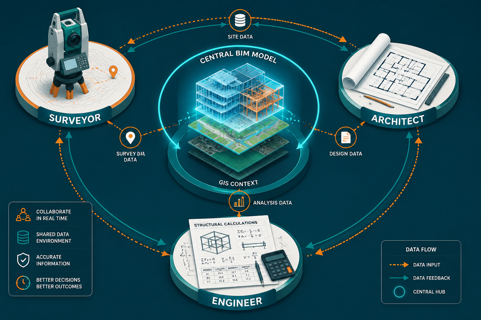
Common Data Environments
A Common Data Environment (CDE) is a centralized digital repository where all project information is stored, shared, and managed. Platforms such as Autodesk Construction Cloud, Trimble Connect, and Oracle Aconex serve this function. When surveyors upload georeferenced data to the CDE, architects and engineers access the same verified dataset — eliminating the version-control chaos that plagues email-based workflows.
Organizations that integrate BIM with project management software through CDEs have achieved 25-40% reductions in project delivery timelines and 15-30% cost savings. [3] Those figures reflect the cumulative benefit of fewer errors, faster decision-making, and reduced rework.
Defined Roles and Information Responsibilities
In a BIM-enabled project, every discipline has a clearly defined information responsibility. The surveyor's role typically covers:
- Pre-design phase: Site surveys, topographic data, utility detection
- Design phase: Verification of design coordinates against site conditions
- Construction phase: Setting-out, progress monitoring, as-built recording
- Post-construction phase: Final as-built model delivery for facilities management
Architects use surveyor data to validate site boundaries and ground conditions before finalizing layouts. Engineers rely on topographic and geotechnical survey data to design foundations, drainage, and structural systems. When these handoffs are formalized in a BIM Execution Plan (BEP), the risk of miscommunication drops sharply.
Information Standards and File Formats
The UK's adoption of ISO 19650 — the international standard for managing information over the whole life cycle of a built asset using BIM — has driven significant improvements in data consistency. Surveyors working on UK projects are expected to align their deliverables with this standard, ensuring that point clouds, DTMs, and survey control data are structured in ways that integrate cleanly with architectural and engineering models.
For property professionals exploring survey design principles, understanding these standards is increasingly important even outside large-scale infrastructure projects.
Quantifying the Efficiency Gains: What the Data Shows
The business case for BIM integration is well-supported by performance data. Beyond the headline figures already cited, BIM delivers measurable efficiency improvements across the project lifecycle.
Timeline and cost benefits:
- BIM users report project timelines that are 10-20% shorter than traditionally managed projects [1]
- Material cost savings of up to 20% are achieved through precise quantity takeoffs generated directly from the BIM model [1]
- Labor hours in drafting, shop drawing production, and fabrication are reduced significantly when BIM models are used as the single source of truth [4]
Quality and risk benefits:
- Fewer requests for information (RFIs) during construction, as design intent is clearer
- Reduced insurance claims related to design errors and omissions
- Better compliance documentation for planning and building regulations
For context, consider a mid-size residential development in London. A surveyor delivering a georeferenced point cloud of an existing terrace into the architect's Revit model allows the design team to plan extensions and alterations with millimeter-level accuracy. This is directly relevant for homeowners and developers exploring building surveys in London as part of their pre-purchase or pre-development due diligence.
The efficiency argument extends to smaller-scale projects too. Understanding the difference between Level 2 and Level 3 surveys is part of selecting the right data capture approach for a given project's BIM requirements.
Overcoming the Barriers to BIM Integration
Despite the compelling evidence, BIM integration is not universally smooth. Several persistent barriers slow adoption, particularly for smaller surveying practices and projects with limited budgets.

Inconsistent Object Libraries and Competing Initiatives
One of the most frequently cited challenges is the inconsistent implementation of BIM object libraries. When different team members use incompatible object standards, the efficiency gains from BIM integration are reduced or eliminated entirely. [4] Competing BIM initiatives within large organizations — where different departments adopt different platforms or workflows — compound this problem.
Solutions include:
- Adopting a single BIM authoring platform for all disciplines on a given project
- Mandating compliance with ISO 19650 and BS EN 17412 in project contracts
- Using federated models rather than forcing all disciplines into a single file
- Establishing a BIM coordinator role responsible for model quality and consistency
Skills Gaps and Training Investment
Many experienced surveyors built their careers on traditional measurement techniques. Transitioning to BIM-compatible workflows requires investment in software training, hardware (laser scanners, GNSS receivers with BIM output capability), and time. Practices that treat this investment as overhead rather than infrastructure tend to fall behind.
Emerging technologies are beginning to ease this transition. Research into adaptive information extraction using large language models (LLMs) is opening new possibilities for automating the translation of BIM data into usable formats, addressing the challenge of BIM heterogeneity across different software environments. [5] Similarly, BIM-enabled augmented reality tools are improving how surveyors and construction teams visualize complex spatial relationships on site. [6]
Data Security and Intellectual Property
Sharing detailed geospatial and structural data across a CDE raises legitimate questions about data security and intellectual property ownership. Clear contractual agreements — specifying who owns the BIM model, who can access which data layers, and how information is protected — are essential before collaboration begins.
For projects involving neighboring properties, this intersects with party wall considerations and the need to document existing conditions before work begins.
Practical Steps for Surveyors Ready to Integrate BIM
For surveying practices looking to deepen their BIM capability in 2026, a phased approach is more sustainable than attempting wholesale transformation overnight.
Phase 1 — Foundation (Months 1-3):
- Audit current data outputs and identify gaps relative to IFC and ISO 19650 requirements
- Invest in point-cloud processing software (e.g., Leica Cyclone, Faro Scene, Autodesk ReCap)
- Establish relationships with a BIM coordinator or consultant for initial projects
Phase 2 — Integration (Months 4-9):
- Deliver first georeferenced point cloud into a live BIM project
- Participate in clash detection reviews alongside architects and engineers
- Develop a practice-specific BIM Execution Plan template
Phase 3 — Leadership (Month 10 onward):
- Position the practice as the geospatial authority within project teams
- Offer as-built BIM verification as a standard service
- Explore drone-based photogrammetry and mobile mapping to accelerate data capture
Surveyors serving specific geographic markets — from Wimbledon property surveyors to Croydon property surveyors — will find that BIM capability increasingly differentiates their practice in competitive local markets.
For those working across London's diverse development landscape, the ability to integrate geospatial survey data into BIM workflows is becoming as fundamental as the ability to operate a total station. Teams in areas like Hammersmith or Islington, where dense urban environments demand precise spatial coordination, stand to gain the most from this capability.
Conclusion
BIM integration for land surveyors collaborating with architects and engineers for enhanced project efficiency is delivering results that are difficult to argue against: fewer design conflicts, shorter timelines, lower costs, and better-informed decisions at every project stage. The surveyor's role has evolved from data provider to strategic collaborator — a shift that rewards practices willing to invest in the skills, tools, and workflows that BIM demands.
Actionable next steps for surveying practices in 2026:
- Assess your current deliverable formats against ISO 19650 requirements and identify the gaps
- Invest in point-cloud processing and BIM-compatible output software as a priority capital item
- Engage directly with architects and engineers on current projects to understand their BIM data needs
- Develop a standard BIM Execution Plan template that defines your practice's information responsibilities
- Pursue CPD training in GIS-BIM integration, particularly the Esri-Autodesk workflow ecosystem
- Market your BIM capability explicitly — clients increasingly specify it in tender requirements
The practices that treat BIM integration as a core competency rather than a specialist add-on will define the next generation of land surveying. The data is clear, the tools are mature, and the collaborative frameworks are established. The remaining variable is commitment.
References
[1] BIM Integration for Land Surveyors Enhancing Construction Efficiency in 2026 – https://kingstonsurveyors.com/bim-integration-for-land-surveyors-enhancing-construction-efficiency-in-2026/?utm_source=openai
[2] GIS and BIM – https://www.esri.com/en-us/industries/aec/overview/gis-and-bim?utm_source=openai
[3] BIM Integration Project Management AEC – https://advaiya.com/bim-integration-project-management-aec/?utm_source=openai
[4] BIM for Transit Infrastructure: A Feasibility and Gap Assessment – https://www.mass.gov/doc/bim-for-transit-infrastructure-a-feasibility-and-gap-assessment-with-current-practices-and-systems-at-the-mbta-0/download?utm_source=openai
[5] Adaptive Exploration for BIM Information Extraction Using LLMs – https://arxiv.org/abs/2605.01698?utm_source=openai
[6] BIMxAR: BIM-Enabled Augmented Reality for Architectural Learning – https://arxiv.org/abs/2204.03207?utm_source=openai


