Survey-grade handheld SLAM systems now start at approximately $25,550 — a price point that would have seemed impossibly low for professional reality capture tools just a decade ago [2]. That single data point tells a larger story: reality capture goes mainstream, from specialized service to standard practice in surveying, is not a future prediction. It is the present reality reshaping how firms win work, deliver results, and compete.
This shift matters for every professional involved in the built environment — from chartered surveyors conducting structural assessments to land surveyors mapping complex sites. Understanding what is driving this change, which tools are involved, and what it means for day-to-day practice is now essential knowledge, not optional reading.
Key Takeaways
- Reality capture has moved from a niche, high-cost service to an accessible standard tool available to surveying firms of all sizes.
- AI, machine learning, and cloud platforms have dramatically reduced the time and skill required to process captured data.
- Clients in 2026 increasingly expect 3D deliverables, point clouds, and digital twins as part of standard survey packages.
- Enterprise adoption — such as Cairn Homes deploying reality capture across more than 25 active sites — signals industry-wide normalization.
- Surveyors who integrate these tools into core service offerings gain measurable advantages in safety, speed, and client satisfaction.
How Reality Capture Evolved From Niche to Necessity
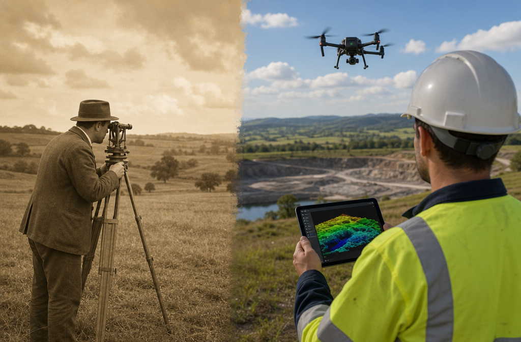
A decade ago, reality capture was the exclusive domain of large engineering consultancies with deep capital budgets. Terrestrial laser scanners cost hundreds of thousands of pounds. Processing point cloud data required specialist software operators. The workflow was slow, expensive, and entirely out of reach for smaller practices.
Three forces changed everything:
1. Hardware cost reduction. The price of survey-grade equipment has fallen sharply. SLAM-based handheld scanners, which allow surveyors to walk through a space and generate a dense 3D point cloud in real time, now enter the market at around $25,550 [2]. Drone-mounted LiDAR and photogrammetry rigs have followed a similar downward curve.
2. Software maturity. Processing pipelines that once required days of manual work now run in hours — or minutes — using automated cloud platforms. Trimble's Reality Capture platform service, integrated with Trimble Connect, enables teams to collaborate and share massive datasets captured with 3D laser scanning, mobile mapping, and UAV systems without needing on-site server infrastructure [5].
3. Market demand. Clients have changed their expectations. Architects, developers, and asset managers now ask for 3D models, point clouds, and digital twins as deliverables — not as premium add-ons, but as baseline requirements [2]. Firms that cannot provide these outputs are increasingly at a competitive disadvantage.
"Reality capture goes mainstream: from specialized service to standard practice in surveying is not a trend to monitor — it is a transition already underway."
For surveyors working across land surveying and professional surveyor services, this evolution demands a practical response. Ignoring it is no longer a neutral choice.
The Tools Driving Mainstream Adoption in 2026
Understanding the specific technologies involved helps clarify why reality capture goes mainstream: from specialized service to standard practice in surveying has accelerated so rapidly. The toolset is broader than many practitioners realize.
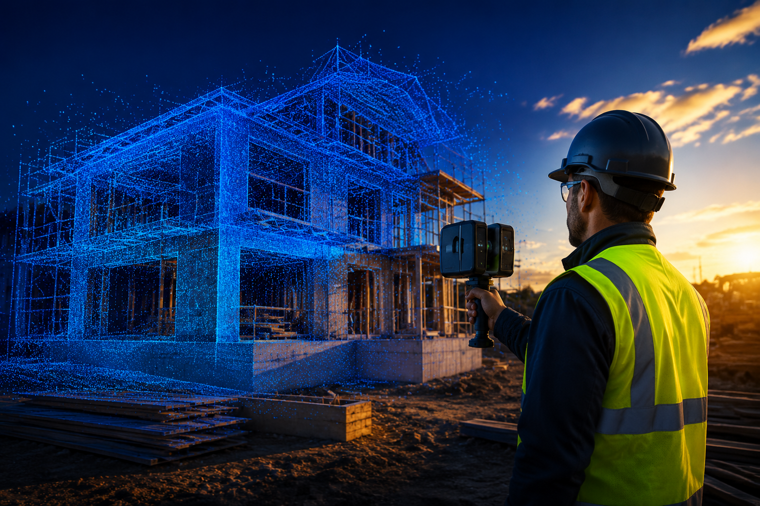
Handheld and Backpack SLAM Scanners
Simultaneous Localization and Mapping (SLAM) devices allow a surveyor to capture a full interior point cloud simply by walking through a building. The scanner tracks its own position relative to its surroundings in real time, eliminating the need for fixed control stations at every setup. This makes interior surveys of complex buildings — including heritage properties, multi-floor residential blocks, and industrial facilities — dramatically faster.
For property inspection and building condition assessment work, this translates directly into reduced site time and more detailed output.
Drone-Based Photogrammetry and LiDAR
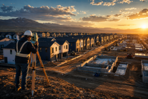
Unmanned Aerial Vehicles (UAVs) equipped with high-resolution cameras or LiDAR sensors can capture topographic surveys, roof inspections, and site progress monitoring with a level of detail that ground-based methods struggle to match. Cairn Homes has standardized the use of drones, 360-degree cameras, and handheld 3D scanning across more than 25 active residential sites, reporting faster inspections and higher data accuracy as direct outcomes [3].
For surveyors involved in full structural inspection work, drone capture provides safe access to areas that would otherwise require scaffolding or rope access — significantly reducing both cost and risk.
360-Degree Camera Systems
While not as geometrically precise as LiDAR, 360-degree camera systems offer a cost-effective way to document site conditions, create virtual walkthroughs, and support schedule of condition records. These systems are particularly valuable for party wall matters and pre-construction condition surveys, where photographic evidence needs to be comprehensive and spatially referenced.
Key Technology Comparison
| Technology | Primary Use | Relative Cost | Data Output |
|---|---|---|---|
| Handheld SLAM Scanner | Interior mapping, as-built surveys | Medium | Dense point cloud |
| Drone LiDAR | Topographic, roof, large-site surveys | Medium-High | Point cloud, DSM |
| Drone Photogrammetry | Site progress, visual inspection | Low-Medium | Orthomosaic, 3D mesh |
| 360-Degree Camera | Condition documentation, walkthroughs | Low | Panoramic imagery |
| Terrestrial Laser Scanner | High-precision structural, heritage | High | Ultra-dense point cloud |
AI, Cloud, and the Democratization of Data Processing
The hardware story is only half the picture. What has truly made reality capture goes mainstream: from specialized service to standard practice in surveying possible is the transformation of the data processing pipeline.
Automated Classification and Segmentation
New AI algorithms can automatically classify and segment captured data — identifying walls, floors, structural elements, vegetation, and utilities without manual intervention [4]. This removes one of the most significant barriers to adoption: the need for highly trained point cloud specialists. A surveyor who understands the built environment can now extract meaningful information from a scan without years of software training.
For building evaluation and expert building evaluation services, automated classification means faster report preparation and more consistent output quality.
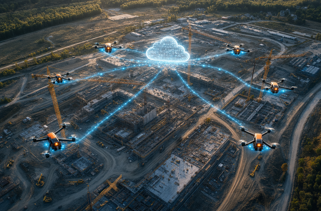
Cloud-Based Collaboration
Cloud platforms have solved the data-sharing problem that plagued early reality capture workflows. Files generated by 3D scanners and drones are enormous — often hundreds of gigabytes per project. Sending them to clients or collaborators was once a logistical challenge. Platforms like Trimble Connect now enable secure, browser-based access to full-resolution datasets, allowing architects, engineers, and clients to review and annotate models without specialist software [5].
This capability has a direct impact on how surveying firms position their services. Offering a client a shareable, navigable 3D model of their property — rather than a PDF report alone — creates a tangible, differentiated deliverable.
GIS Integration and Digital Twins
The incorporation of photogrammetry workflows into enterprise Geographic Information Systems (GIS) is transforming physical infrastructure into continuously updated operational data [6]. For asset managers and local authorities, this means a building or road network is no longer documented at a single point in time — it becomes a living dataset that evolves with the asset.
This integration is particularly relevant for other property services that extend beyond a single survey event into ongoing asset management relationships.
What This Means for Surveying Practice: Safety, Speed, and Client Value

The practical implications of mainstream reality capture adoption are significant across three dimensions: safety, operational efficiency, and the value delivered to clients.
Enhanced Safety on Hazardous Sites
Reality capture allows surveyors to document confined spaces, underground utilities, and structurally compromised areas without physical entry [2]. A drone can survey a deteriorating roof. A SLAM scanner can map a basement with poor air quality. This is not a minor operational benefit — it represents a fundamental improvement in how surveying firms manage risk.
Firms operating across London and the South East, where older building stock presents frequent access challenges, stand to gain particularly from these capabilities. Whether working in Wandsworth, Islington, or Hillingdon, the ability to capture data remotely reduces exposure to site hazards without compromising survey quality.
Faster Project Delivery
Traditional measured surveys of complex buildings can take days of site time followed by weeks of drafting. SLAM-based capture of the same building might take hours, with automated processing delivering a usable point cloud the same day. Firms that have adopted these workflows report measurable reductions in project timelines [1].
For clients with tight construction programmes or transaction deadlines, faster delivery is a competitive differentiator that justifies investment in the technology.
Meeting Evolved Client Expectations
Clients in 2026 are increasingly informed about what digital survey technology can produce. Developers, architects, and asset managers who have worked with reality capture data on one project will expect it on the next. Firms that still deliver only 2D drawings and written reports risk being perceived as behind the curve [2].
This does not mean every survey requires a full digital twin. The appropriate level of technology should match the project brief and budget. But having the capability — and being able to articulate its value — is now a baseline expectation for firms competing for significant instructions.
Barriers to Adoption and How Firms Are Overcoming Them
Despite the clear momentum, reality capture goes mainstream: from specialized service to standard practice in surveying does not mean adoption has been universal or frictionless. Several barriers remain.
Cost of entry. While hardware costs have fallen, the investment required to equip a team with SLAM scanners, drones, and processing software remains substantial. Many smaller firms are addressing this through equipment hire, sub-contracting specialist capture to dedicated reality capture providers, or phased investment starting with drone photogrammetry.
Skills gap. Operating the hardware is relatively straightforward. Interpreting the data, managing quality assurance, and integrating outputs into professional reports requires training. Industry bodies and universities are responding — virtual reality platforms like VRISE are being developed to provide immersive surveying education that addresses challenges in traditional instruction [7].
Data management. Large point cloud files require robust storage and processing infrastructure. Cloud platforms have eased this burden, but firms need clear workflows for data naming, archiving, and client delivery.
Regulatory and liability considerations. Drone operations in the UK require Civil Aviation Authority (CAA) authorisation for commercial work. Surveyors integrating UAV capture into their services need to ensure compliance with airspace regulations and that their professional indemnity insurance covers the expanded scope of work.
Integrating Reality Capture Into Core Service Offerings
The firms gaining the most from this transition are not those treating reality capture as a bolt-on service. They are those weaving it into the fabric of their core offerings — using it to enhance the quality of property condition assessment work, to produce richer evidence for structural survey importance reports, and to deliver more compelling outputs across all service lines.
A practical integration pathway for most surveying practices looks like this:
- Stage 1: Introduce drone photogrammetry for roof and external envelope surveys. Low cost, immediate safety benefit, visible client value.
- Stage 2: Add 360-degree camera documentation to condition surveys and party wall inspections. Enhances the evidential record without significant workflow disruption.
- Stage 3: Invest in or sub-contract SLAM scanning for complex interior surveys and as-built documentation. Targets the projects where the time and quality benefit is most pronounced.
- Stage 4: Develop cloud-based delivery and collaboration workflows. Positions the firm to offer digital twin and ongoing asset management services.
Each stage builds capability, client familiarity, and internal confidence before committing to the next level of investment.
Conclusion
Reality capture goes mainstream: from specialized service to standard practice in surveying is a transition with clear winners and clear risks. The winners are firms that act with intention — investing in the right tools, training their teams, and communicating the value of digital deliverables to clients. The risks belong to those who treat this as a passing trend rather than a structural shift in how the profession operates.
Actionable next steps for surveying professionals in 2026:
- Audit your current service offering against client expectations. Are clients asking for outputs you cannot currently provide?
- Identify one area of your practice — roof surveys, condition records, interior as-builts — where reality capture would deliver an immediate, measurable improvement.
- Research equipment hire or sub-contracting options before committing to capital expenditure. Prove the workflow before buying the hardware.
- Review your CAA drone authorisation status and professional indemnity cover if UAV operations are part of your plan.
- Explore cloud collaboration platforms that allow clients to interact with 3D data. The ability to share a navigable model is often the most persuasive demonstration of value.
The technology is accessible. The client demand is real. The competitive advantage for early adopters is diminishing as adoption accelerates — which means the time to act is now, not after the next technology cycle.
References
[1] Doubling Down On Digital – https://amerisurv.com/2026/02/01/doubling-down-on-digital/?utm_source=openai
[2] Reality Capture Goes Mainstream Tools Every Property Surveyor Needs In 2026 – https://kingstonsurveyors.com/reality-capture-goes-mainstream-tools-every-property-surveyor-needs-in-2026/?utm_source=openai
[3] pbctoday.co.uk – https://www.pbctoday.co.uk/news/digital-construction-news/construction-technology-news/cairn-rollout-dronedeploys-reality-capture-across-residential-portfolio/160654/?utm_source=openai
[4] Ai And The Future Of Reality Capture – https://pure-surveying.com/2025/01/02/ai-and-the-future-of-reality-capture/?utm_source=openai
[5] Trimble Announces Reality Capture Platform Service – https://www.engineering.com/trimble-announces-reality-capture-platform-service/?utm_source=openai
[6] From Trenches To Digital Twins – https://highways.today/2026/02/18/from-trenches-to-digital-twins/?utm_source=openai
[7] arxiv – https://arxiv.org/abs/2507.22810?utm_source=openai