The surveying industry has reached a pivotal moment. What once required weeks of fieldwork, multiple site visits, and substantial ground crews can now be accomplished in hours with a single drone flight. But here's the challenge: Multi-Sensor Drone Integration: Choosing the Right Sensor Array for Your Surveying Projects in 2026 has become more complex than ever, with dozens of sensor combinations promising revolutionary results while demanding significant investment.
The question isn't whether to adopt drone technology—it's which sensors deliver genuine return on investment for your specific surveying applications. In 2026, synchronized sensor integration has become standard practice, with modern UAV systems combining LiDAR, photogrammetry cameras, multispectral sensors, and thermal imaging units operating simultaneously[1]. This advancement means surveyors can capture comprehensive datasets in a single flight, but it also requires strategic decision-making about sensor selection and integration.
This comprehensive guide cuts through the marketing hype to provide practical insights into Multi-Sensor Drone Integration: Choosing the Right Sensor Array for Your Surveying Projects in 2026, helping surveying professionals understand which sensor combinations deliver measurable value without overwhelming capital expenditure.
Key Takeaways
- 🚁 Synchronized multi-sensor systems enable comprehensive data capture in single flights, eliminating the need for multiple site visits and dramatically reducing project timelines
- 📊 LiDAR has become the go-to standard for topographic surveys, forestry assessments, and infrastructure mapping due to drastically reduced costs and improved accuracy under challenging conditions[2]
- 🎯 RTK/PPK GNSS technology now delivers centimeter-level accuracy, significantly reducing ground control point dependency and transforming survey-grade data acquisition standards[2]
- 🤖 AI-powered validation and autonomous operations provide real-time data quality assurance and enable continuous monitoring through drone-in-a-box systems without on-site pilots[1][2]
- 💰 Strategic sensor selection based on project requirements delivers superior ROI compared to purchasing maximum capability systems for applications that don't require advanced features
Understanding Modern Drone Sensor Technologies
The foundation of effective Multi-Sensor Drone Integration: Choosing the Right Sensor Array for Your Surveying Projects in 2026 begins with understanding what each sensor type actually delivers and where it excels.
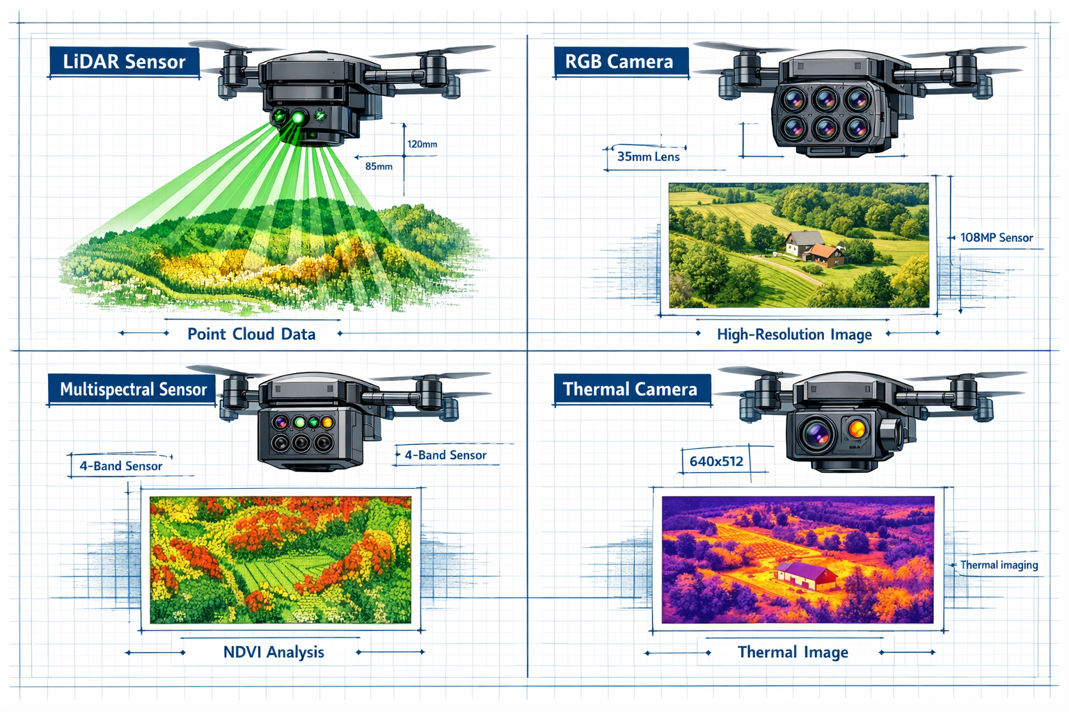
LiDAR: The New Standard for Precision Mapping
Light Detection and Ranging (LiDAR) has transformed from a premium option to the go-to standard method for topographic surveys, forestry assessments, electric powerline mapping, and mining exploration[2]. This shift occurred due to drastically reduced costs and substantially improved sensor capabilities.
Modern LiDAR UAVs feature several critical advancements:
- Faster Pulse Repetition Rates (PRR) enabling higher point density and improved detail capture
- Enhanced Inertial Measurement Unit (IMU) integration for more accurate positioning data
- Superior performance under dense canopies where photogrammetry traditionally struggles
- Direct measurement capabilities that don't rely on ambient lighting conditions
LiDAR excels in applications requiring precise elevation data, including contour mapping, volumetric calculations, and terrain modeling. A single UAV mission can now survey hundreds of acres in hours, delivering survey-grade outputs including contours and CAD-ready files with minimal site disruption[2].
The technology proves particularly valuable for construction surveying applications where accurate elevation data forms the foundation for project planning and execution.
Photogrammetry: High-Resolution Visual Documentation
RGB photogrammetry cameras remain essential for creating detailed visual records and generating orthomosaic maps. These sensors capture high-resolution imagery that software processes into 3D models, digital surface models, and georeferenced maps.
Key advantages of photogrammetry include:
- True-color imagery that stakeholders easily understand
- Texture and visual detail that LiDAR cannot capture
- Lower equipment costs compared to LiDAR systems
- Excellent performance in open areas with good lighting
Photogrammetry works best for visual inspection, progress documentation, and creating client-friendly deliverables. When combined with RTK/PPK GNSS technology, photogrammetry systems now achieve centimeter-level accuracy that meets survey-grade requirements[2].
Multispectral Sensors: Beyond Visible Light
Multispectral imaging captures data across multiple electromagnetic spectrum bands, revealing information invisible to the human eye. While traditionally associated with agricultural applications, these sensors provide valuable insights for various surveying projects.
Multispectral sensors excel at:
- Vegetation health analysis through NDVI (Normalized Difference Vegetation Index) calculations
- Moisture detection in soil and building materials
- Material differentiation based on spectral signatures
- Environmental monitoring and change detection over time
For surveying professionals working on projects involving vegetation management, environmental assessment, or infrastructure monitoring, multispectral data adds a critical analytical dimension.
Thermal Imaging: Temperature-Based Analysis
Thermal cameras detect infrared radiation, creating images based on temperature differences rather than visible light. This capability opens unique applications in surveying and inspection work.
Thermal sensors provide value through:
- Heat loss detection in building envelope assessments
- Moisture identification in roofing and structural materials
- Electrical system inspection identifying overheating components
- Solar panel efficiency analysis detecting underperforming units
When integrated with other sensors, thermal imaging adds a diagnostic capability that identifies issues invisible to traditional surveying methods. This proves particularly valuable for professionals conducting building surveyor services where identifying hidden defects saves clients significant future expenses.
RTK/PPK GNSS: The Accuracy Foundation
Real-Time Kinematic (RTK) and Post-Processed Kinematic (PPK) GNSS technology represents one of the most significant advancements in drone surveying accuracy. These systems have fundamentally changed survey-grade data acquisition standards by delivering centimeter-level accuracy[2].
Understanding RTK vs. PPK
RTK systems receive correction data in real-time from a base station, enabling immediate centimeter-level positioning during flight. This requires maintaining a communication link between the drone and base station throughout the mission.
PPK systems record raw GNSS data during flight and apply corrections during post-processing. This approach offers several advantages:
- No real-time communication required between drone and base station
- More reliable in challenging environments where radio links may be interrupted
- Ability to reprocess data with different correction parameters if needed
- Better performance over longer distances from the base station
Reduced Ground Control Point Dependency
The advancement of RTK/PPK technology has significantly decreased Ground Control Point (GCP) dependency[2]. This transformation particularly benefits:
- Remote location surveys where establishing GCPs proves difficult or expensive
- Linear infrastructure projects like pipelines, roads, and powerlines where GCP placement becomes impractical
- Rapid response applications requiring immediate deployment without extensive ground preparation
- Repeat monitoring projects where consistent reference points accelerate workflows
For surveying professionals, this means faster project turnaround, reduced field crew requirements, and lower operational costs while maintaining survey-grade accuracy standards.
Strategic Sensor Selection for Different Project Types
Effective Multi-Sensor Drone Integration: Choosing the Right Sensor Array for Your Surveying Projects in 2026 requires matching sensor capabilities to specific project requirements. Not every project needs every sensor—strategic selection maximizes ROI.
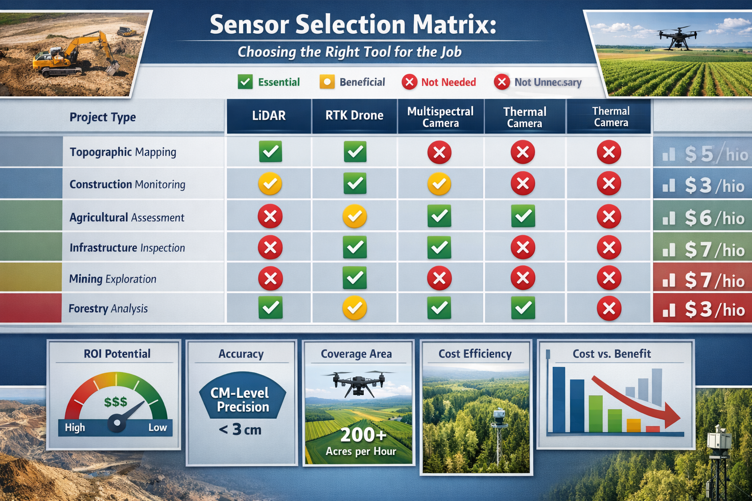
Topographic and Cadastral Surveys
Recommended sensor array: LiDAR + RTK/PPK GNSS + RGB camera
Topographic surveys demand precise elevation data and accurate horizontal positioning. LiDAR's ability to penetrate vegetation and measure ground surface directly makes it ideal for terrain modeling. The RGB camera provides visual context and aids in feature identification during processing.
Key benefits:
- Centimeter-level vertical accuracy for contour generation
- Rapid coverage of large areas (hundreds of acres per flight)
- CAD-ready deliverables with minimal manual editing
- Vegetation penetration for true ground surface modeling
This combination delivers survey-grade results that meet professional standards while dramatically reducing field time compared to traditional methods.
Construction Site Monitoring and Progress Documentation
Recommended sensor array: RGB photogrammetry + RTK/PPK GNSS (thermal imaging optional for specific applications)
Construction projects require regular documentation, volumetric calculations, and visual progress records. High-resolution photogrammetry creates detailed orthomosaics and 3D models that stakeholders easily interpret.
Key benefits:
- True-color imagery for client presentations and reports
- Accurate stockpile volume calculations
- Change detection between survey dates
- Visual documentation for dispute resolution
Adding thermal imaging proves valuable for building envelope inspections and identifying installation defects in mechanical systems. Professionals conducting condition surveys benefit from the diagnostic capabilities thermal sensors provide.
Agricultural and Environmental Assessment
Recommended sensor array: Multispectral + RGB photogrammetry + RTK/PPK GNSS
Agricultural applications and environmental monitoring require spectral analysis to assess vegetation health, identify stress patterns, and monitor changes over time.
Key benefits:
- NDVI and other vegetation indices for health assessment
- Early stress detection before visible symptoms appear
- Precise area measurements for treatment planning
- Historical comparison for trend analysis
The combination of multispectral data and high-resolution imagery provides both analytical metrics and visual documentation.
Infrastructure Inspection and Asset Management
Recommended sensor array: RGB photogrammetry + thermal imaging + RTK/PPK GNSS (LiDAR for complex structures)
Infrastructure inspection requires detailed visual documentation and diagnostic capabilities to identify defects, deterioration, and maintenance needs.
Key benefits:
- High-resolution imagery revealing surface defects
- Thermal analysis identifying electrical issues and insulation failures
- Georeferenced data for asset management systems
- Safe inspection of dangerous or difficult-to-access structures
For linear infrastructure like powerlines and pipelines, adding LiDAR enables precise clearance measurements and encroachment detection. This sensor combination supports comprehensive data analysis workflows that inform maintenance decisions.
Mining and Quarry Operations
Recommended sensor array: LiDAR + RGB photogrammetry + RTK/PPK GNSS
Mining operations require accurate volumetric calculations, slope stability analysis, and regular progress monitoring. LiDAR's precision and ability to capture detailed terrain features makes it essential.
Key benefits:
- Highly accurate volume calculations for inventory management
- Slope analysis for safety assessment
- Rapid surveying of active operations with minimal disruption
- Change detection for production tracking
The combination of LiDAR point clouds and photogrammetric textures creates comprehensive digital twins of mining operations.
Forestry and Vegetation Management
Recommended sensor array: LiDAR + multispectral + RGB photogrammetry + RTK/PPK GNSS
Forestry applications require both structural data (tree height, canopy density) and health assessment (vegetation vigor, stress identification).
Key benefits:
- Canopy penetration for ground surface modeling
- Tree height and biomass estimation
- Vegetation health analysis through spectral indices
- Change detection for growth monitoring and harvest planning
This comprehensive sensor array provides the data needed for sustainable forest management and conservation planning.
Autonomous Operations and AI Integration
The advancement of Multi-Sensor Drone Integration: Choosing the Right Sensor Array for Your Surveying Projects in 2026 extends beyond hardware to include intelligent software and autonomous capabilities that maximize efficiency and data quality.
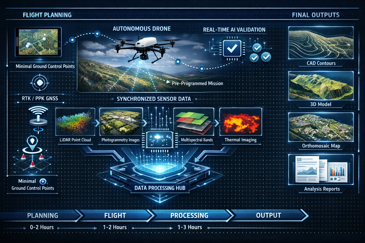
Autonomous Flight Planning with Predictive Modeling
Modern drone systems feature autonomous flight planning with predictive modeling that automatically adjusts altitude, angle, and sensor selection to achieve optimal readings without operator intervention[1]. This intelligence ensures:
- Consistent data quality across entire survey areas
- Optimized flight parameters for specific sensor requirements
- Adaptive responses to terrain variations and obstacles
- Efficient battery usage through optimized flight paths
Surveyors can define project parameters and quality requirements, then let the system determine the optimal flight strategy to achieve those goals.
Drone-in-a-Box Systems for Continuous Monitoring
Autonomous drone-in-a-box systems have become common in 2026, enabling continuous infrastructure monitoring and scheduled inspections without on-site pilots[2]. These systems provide:
- Scheduled automated surveys for regular monitoring applications
- Weather-triggered missions responding to specific conditions
- Immediate deployment for emergency response situations
- Reduced operational costs through eliminated travel and personnel requirements
For organizations managing distributed infrastructure or requiring frequent monitoring, drone-in-a-box systems deliver consistent data collection with minimal human intervention.
Real-Time AI-Powered Data Validation
AI-powered onboard data validation occurs in real-time, alerting surveyors to inconsistencies before projects reach the drafting stage[1][2]. This capability represents a fundamental shift in quality assurance:
Traditional workflow challenges:
- Data quality issues discovered days after fieldwork
- Expensive return visits to capture missing or poor-quality data
- Processing delays when data proves unusable
- Client timeline impacts from data recapture requirements
AI validation benefits:
- Immediate notification of coverage gaps during flight
- Real-time quality metrics for sensor data
- Automatic mission adjustment to address deficiencies
- Confidence in data completeness before leaving the site
This technology essentially eliminates the costly problem of discovering data issues after field crews have departed, significantly improving project efficiency.
AI/ML as the Biggest Transformative Event
AI and machine learning represent "the biggest transformative event" of 2026 in drone surveying, automating processes that previously took surveyors days or weeks[2]. These capabilities include:
- Automated feature extraction identifying buildings, roads, utilities, and other features from point clouds and imagery
- Change detection comparing datasets from different dates to identify modifications
- Defect identification recognizing cracks, corrosion, and other issues in infrastructure inspections
- Point cloud classification automatically categorizing ground, vegetation, buildings, and other elements
The industry is advancing toward push-button automation, with software enabling users to upload drone images and receive production-ready deliverables with virtually zero manual intervention required[4]. While this represents the industry roadmap as of late 2025[4], the trend clearly indicates where surveying workflows are heading.
Beyond Visual Line of Sight (BVLOS) Operations
Beyond Visual Line of Sight (BVLOS) operations are now increasingly approved for commercial use in 2026, with Remote ID fully integrated into airspace management systems[2]. This regulatory advancement fundamentally changes what's possible with drone surveying.
BVLOS Benefits for Surveying Applications
BVLOS authorization enables:
- Linear infrastructure surveys covering miles of pipelines, powerlines, or roads in single missions
- Large property surveys exceeding visual range limitations
- Remote location access without requiring crew positioning along entire survey routes
- Improved efficiency through longer flight times and greater coverage areas
For surveying professionals working on extensive projects, BVLOS capability transforms operational economics by dramatically reducing crew deployment costs and project timelines.
Remote ID and Airspace Integration
The full integration of Remote ID into airspace management systems provides:
- Automated airspace authorization through digital systems
- Real-time conflict detection with other airspace users
- Compliance documentation for regulatory requirements
- Enhanced safety through improved situational awareness
These systems work seamlessly with flight planning software, handling authorization requests and airspace coordination automatically.
Integration Considerations and Best Practices
Successfully implementing Multi-Sensor Drone Integration: Choosing the Right Sensor Array for Your Surveying Projects in 2026 requires attention to several practical considerations beyond sensor selection.
Payload Weight and Flight Time Trade-offs
Each additional sensor adds weight, reducing flight time and coverage area per battery. Strategic considerations include:
Single-sensor optimization:
- Longer flight times
- Greater coverage per mission
- Simpler data processing workflows
- Lower equipment costs
Multi-sensor integration:
- Comprehensive data capture in single flights
- Reduced total site visits
- More complex data processing
- Higher equipment investment
The optimal balance depends on whether your projects require multiple data types and whether the value of single-flight capture justifies reduced flight time per battery.
Data Processing Requirements
Different sensors generate vastly different data volumes and processing requirements:
| Sensor Type | Data Volume | Processing Complexity | Specialized Software Required |
|---|---|---|---|
| RGB Photogrammetry | High | Moderate | Photogrammetry software |
| LiDAR | Very High | High | Point cloud processing |
| Multispectral | High | Moderate | Agricultural/spectral analysis |
| Thermal | Moderate | Low to Moderate | Thermal analysis software |
Organizations must ensure adequate computing resources and software capabilities to process the data their sensor arrays generate. The industry trend toward AI-assisted processing helps manage this complexity, but hardware and software investments remain necessary.
Calibration and Maintenance
Multi-sensor systems require regular calibration to maintain accuracy:
- Sensor alignment ensuring all sensors capture data from consistent positions
- IMU calibration maintaining accurate orientation data
- GNSS antenna measurements verifying precise positioning offsets
- Sensor-specific calibration following manufacturer recommendations
Establishing regular maintenance schedules and calibration protocols ensures consistent data quality across projects. This proves particularly important for professionals conducting chartered surveyor work where accuracy standards carry professional liability implications.
Training and Skill Development
Effective multi-sensor drone operation requires skills beyond basic piloting:
- Sensor operation understanding optimal settings for different conditions
- Flight planning optimizing missions for specific sensor requirements
- Data processing managing workflows for multiple data types
- Quality control validating output accuracy and completeness
Organizations should budget for training investments alongside equipment purchases to maximize return on their sensor array investments.
Cost-Benefit Analysis and ROI Considerations
Making informed decisions about Multi-Sensor Drone Integration: Choosing the Right Sensor Array for Your Surveying Projects in 2026 requires realistic assessment of costs versus benefits.
Initial Investment Breakdown
Entry-level survey drone system (RGB photogrammetry + RTK/PPK):
- Drone platform: £8,000 – £15,000
- RTK/PPK module: £3,000 – £8,000
- Base station: £2,000 – £5,000
- Software licenses: £1,500 – £4,000 annually
- Total initial investment: £14,500 – £32,000
Mid-range multi-sensor system (RGB + LiDAR + RTK/PPK):
- Drone platform: £15,000 – £30,000
- LiDAR sensor: £25,000 – £80,000
- RTK/PPK system: £5,000 – £10,000
- Processing software: £3,000 – £8,000 annually
- Total initial investment: £48,000 – £128,000
Advanced multi-sensor system (RGB + LiDAR + multispectral + thermal + RTK/PPK):
- Drone platform: £25,000 – £45,000
- LiDAR sensor: £40,000 – £100,000
- Multispectral sensor: £8,000 – £20,000
- Thermal camera: £5,000 – £15,000
- RTK/PPK system: £5,000 – £10,000
- Comprehensive software suite: £5,000 – £12,000 annually
- Total initial investment: £88,000 – £202,000
Operational Cost Savings
The ROI calculation must consider operational cost reductions compared to traditional surveying methods:
Traditional topographic survey (50-acre site):
- Field crew (3 people, 3-5 days): £4,500 – £7,500
- Equipment rental: £800 – £1,500
- Travel and accommodation: £1,200 – £2,000
- Total project cost: £6,500 – £11,000
Drone survey (same 50-acre site):
- Flight time: 2-4 hours
- Operator time: 1 day
- Processing time: 1-2 days
- Personnel cost: £800 – £1,600
- Total project cost: £800 – £1,600
Savings per project: £5,700 – £9,400
For surveying firms conducting regular projects, these savings accumulate rapidly. A mid-range LiDAR system costing £75,000 could achieve ROI within 10-15 similar projects, potentially within a single busy season.
Revenue Expansion Opportunities
Multi-sensor capabilities enable surveying firms to offer new services:
- Infrastructure inspection contracts requiring thermal and visual analysis
- Agricultural monitoring services utilizing multispectral data
- Environmental assessment projects combining multiple data types
- Construction monitoring subscriptions providing regular progress documentation
These expanded service offerings create new revenue streams that accelerate ROI beyond simple cost replacement calculations. Professionals can leverage these capabilities alongside traditional services like homebuyers surveys to diversify their practice offerings.
Future-Proofing Your Sensor Investment
Technology advancement continues at a rapid pace. Strategic approaches to Multi-Sensor Drone Integration: Choosing the Right Sensor Array for Your Surveying Projects in 2026 should consider future developments.
Modular Systems and Upgrade Paths
Selecting platforms with modular sensor mounting enables:
- Phased investment starting with essential sensors and adding capabilities as needed
- Technology upgrades replacing individual sensors without complete system replacement
- Project-specific configuration using different sensor combinations for different applications
- Reduced obsolescence risk through component-level updates
Modular approaches provide flexibility as project requirements evolve and technology improves.
Software Ecosystem Considerations
The software ecosystem supporting your sensors proves as important as the hardware:
Key factors to evaluate:
- Regular software updates and feature additions
- Active user community and support resources
- Integration with industry-standard CAD and GIS platforms
- AI and automation roadmap
- Subscription costs and licensing models
Software capabilities increasingly differentiate surveying outcomes, with AI-powered automation representing the most significant value-add in 2026[2].
Regulatory Compliance and Standards
Ensuring your sensor systems meet evolving regulatory requirements protects your investment:
- Remote ID compliance for airspace integration
- Data security standards for sensitive project information
- Professional surveying standards for accuracy and quality
- Privacy regulations for image and thermal data collection
Selecting equipment from manufacturers committed to regulatory compliance reduces the risk of systems becoming unusable due to changing requirements.
Making Your Sensor Selection Decision
The path to effective Multi-Sensor Drone Integration: Choosing the Right Sensor Array for Your Surveying Projects in 2026 follows a systematic evaluation process.
Step 1: Analyze Your Project Portfolio
Review your typical projects over the past 12-24 months:
- What percentage require precise elevation data?
- How many involve vegetation analysis or agricultural applications?
- What proportion need thermal inspection capabilities?
- How often do projects require rapid turnaround times?
- Which projects currently prove most expensive to execute?
This analysis reveals which sensor capabilities deliver the most value for your specific practice.
Step 2: Calculate Realistic ROI Scenarios
Develop financial models based on actual project data:
- Identify 5-10 recent projects that drone surveys could have improved
- Calculate traditional execution costs versus estimated drone survey costs
- Factor in your expected project volume over the next 2-3 years
- Include ongoing costs (software subscriptions, maintenance, training)
- Determine realistic payback periods for different investment levels
Conservative financial projections provide confidence in investment decisions.
Step 3: Start with Core Capabilities
For most surveying applications, the optimal starting point includes:
Essential sensor array:
- High-resolution RGB camera for photogrammetry
- RTK/PPK GNSS for survey-grade accuracy
- Reliable drone platform with adequate flight time
This combination addresses the majority of surveying needs while maintaining manageable investment levels and operational complexity.
Step 4: Add Specialized Sensors Based on Demand
Expand your sensor array as specific project demands justify:
- Add LiDAR when topographic projects become regular work
- Add multispectral when agricultural or environmental projects create consistent demand
- Add thermal when inspection services represent growth opportunities
This phased approach aligns investment with demonstrated demand rather than speculative capability.
Step 5: Evaluate Partnerships and Service Providers
Consider whether purchasing equipment makes sense versus partnering:
Purchase equipment when:
- Project volume justifies investment within reasonable payback period
- In-house capability provides competitive advantage
- Immediate deployment capability proves essential
- Long-term cost savings exceed partnership fees
Partner with service providers when:
- Project volume remains inconsistent
- Specialized sensors needed only occasionally
- Capital investment exceeds current financial capacity
- Focus on core surveying services makes more sense than equipment operation
Many successful surveying practices combine owned basic systems with partnerships for specialized capabilities, optimizing both flexibility and investment efficiency.
Conclusion
Multi-Sensor Drone Integration: Choosing the Right Sensor Array for Your Surveying Projects in 2026 represents a strategic decision that balances capability, investment, and practical application requirements. The technology has matured to deliver genuine survey-grade accuracy with dramatically improved efficiency compared to traditional methods.
The synchronized integration of LiDAR, photogrammetry, multispectral, and thermal sensors enables comprehensive data capture in single flights that previously required multiple site visits[1]. RTK/PPK GNSS technology delivering centimeter-level accuracy has reduced ground control point dependency, particularly benefiting remote locations and linear infrastructure projects[2]. AI-powered validation and autonomous operations provide real-time quality assurance while drone-in-a-box systems enable continuous monitoring without on-site pilots[1][2].
However, success doesn't require purchasing every available sensor. Strategic selection based on actual project requirements delivers superior ROI compared to maximum-capability systems used for applications that don't require advanced features.
Actionable Next Steps
For surveying professionals ready to implement or expand drone capabilities:
-
Conduct a comprehensive project portfolio analysis identifying which sensor types would improve efficiency or enable new services for your specific practice
-
Develop detailed financial models calculating realistic ROI based on your actual project volume and pricing, not generic industry examples
-
Start with proven core capabilities (RGB photogrammetry + RTK/PPK GNSS) that address the majority of surveying applications before investing in specialized sensors
-
Establish relationships with equipment suppliers and training providers who can support your implementation with ongoing technical assistance and skill development
-
Create a phased expansion plan adding specialized sensors (LiDAR, multispectral, thermal) as demonstrated project demand justifies the investment
-
Invest in software and processing capabilities alongside hardware, recognizing that AI-powered automation increasingly differentiates surveying outcomes
-
Stay informed about regulatory developments including BVLOS authorization processes and airspace management systems that expand operational possibilities
The surveying industry transformation driven by multi-sensor drone integration continues to accelerate in 2026. Professionals who strategically adopt these technologies position themselves to deliver superior value to clients while building more efficient, profitable practices. The key lies not in acquiring maximum technology, but in selecting the right sensor array that aligns with your specific project requirements and business objectives.
Whether you're conducting traditional building surveyor services, specialized construction surveying, or expanding into new service areas, the strategic integration of appropriate drone sensor arrays provides the foundation for competitive advantage in an increasingly technology-driven profession.
References
[1] Future Land Surveying 2026 – https://haller-blanchard.com/future-land-surveying-2026/
[2] How Drones Are Transforming Surveying Mapping And Inspection In 2026 – https://www.uavsphere.com/post/how-drones-are-transforming-surveying-mapping-and-inspection-in-2026
[3] Drone Surveying – https://uavcoach.com/drone-surveying/
[4] Drone Mapping Trends 2026 Simactive – https://dronelife.com/2025/12/03/drone-mapping-trends-2026-simactive/
[5] Autonomous Drones In Land Surveying Capturing Large Scale Properties With Multi Sensor Precision – https://nottinghillsurveyors.com/blog/autonomous-drones-in-land-surveying-capturing-large-scale-properties-with-multi-sensor-precision