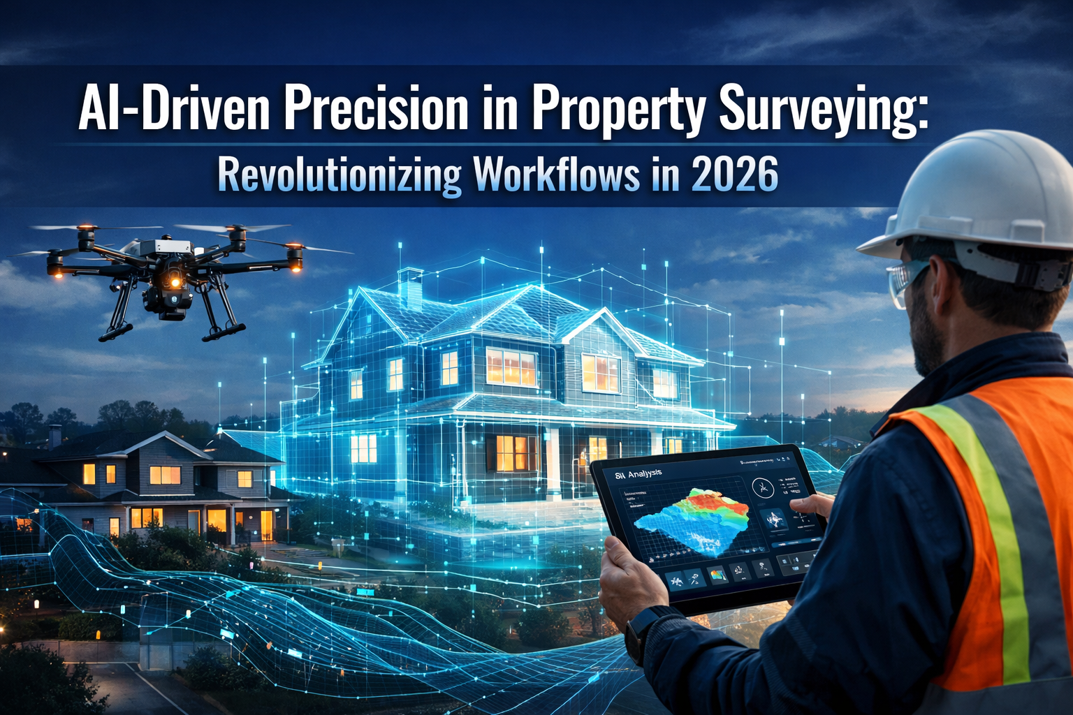
The property surveying industry stands at a transformative crossroads in 2026. What once required multiple site visits, weeks of manual data processing, and extensive human interpretation can now be accomplished in a fraction of the time with unprecedented accuracy. AI-Driven Precision in Property Surveying: Revolutionizing Workflows in 2026 represents more than just technological advancement—it marks a fundamental shift in how surveying professionals approach their craft, deliver value to clients, and navigate increasingly complex property landscapes.
Imagine an autonomous drone that automatically adjusts its altitude and sensor configuration to capture optimal property data, while AI algorithms simultaneously process that information into detailed 3D models, identify potential structural issues, and flag boundary anomalies—all before the surveyor returns to the office. This isn't science fiction; it's the reality of modern surveying practice in 2026.
Key Takeaways
✅ Autonomous technology has revolutionized data collection, with AI-powered drones capable of conducting comprehensive property surveys with minimal human intervention
✅ Workflow integration now sees AI embedded directly into core surveying processes, automatically classifying terrain, identifying markers, and generating preliminary models that previously required days of manual work
✅ Real-time digital twins enable surveyors to create accurate 3D representations of properties, integrating seamlessly with Building Information Modeling (BIM) for enhanced collaboration
✅ Professional judgment remains essential, as RICS confirms that while AI enhances efficiency and accuracy, it cannot replace the expertise and nuanced decision-making of qualified surveyors
✅ Client expectations have evolved, with property buyers and developers now expecting rich digital deliverables and rapid turnaround times that AI-enhanced workflows make possible
Understanding the AI Revolution in Property Surveying
The integration of artificial intelligence into property surveying represents a paradigm shift that extends far beyond simple automation. In 2026, AI systems have become sophisticated partners in the surveying process, capable of handling complex analytical tasks while enabling human professionals to focus on interpretation, client consultation, and strategic decision-making.
How AI Enhances Traditional Surveying Methods
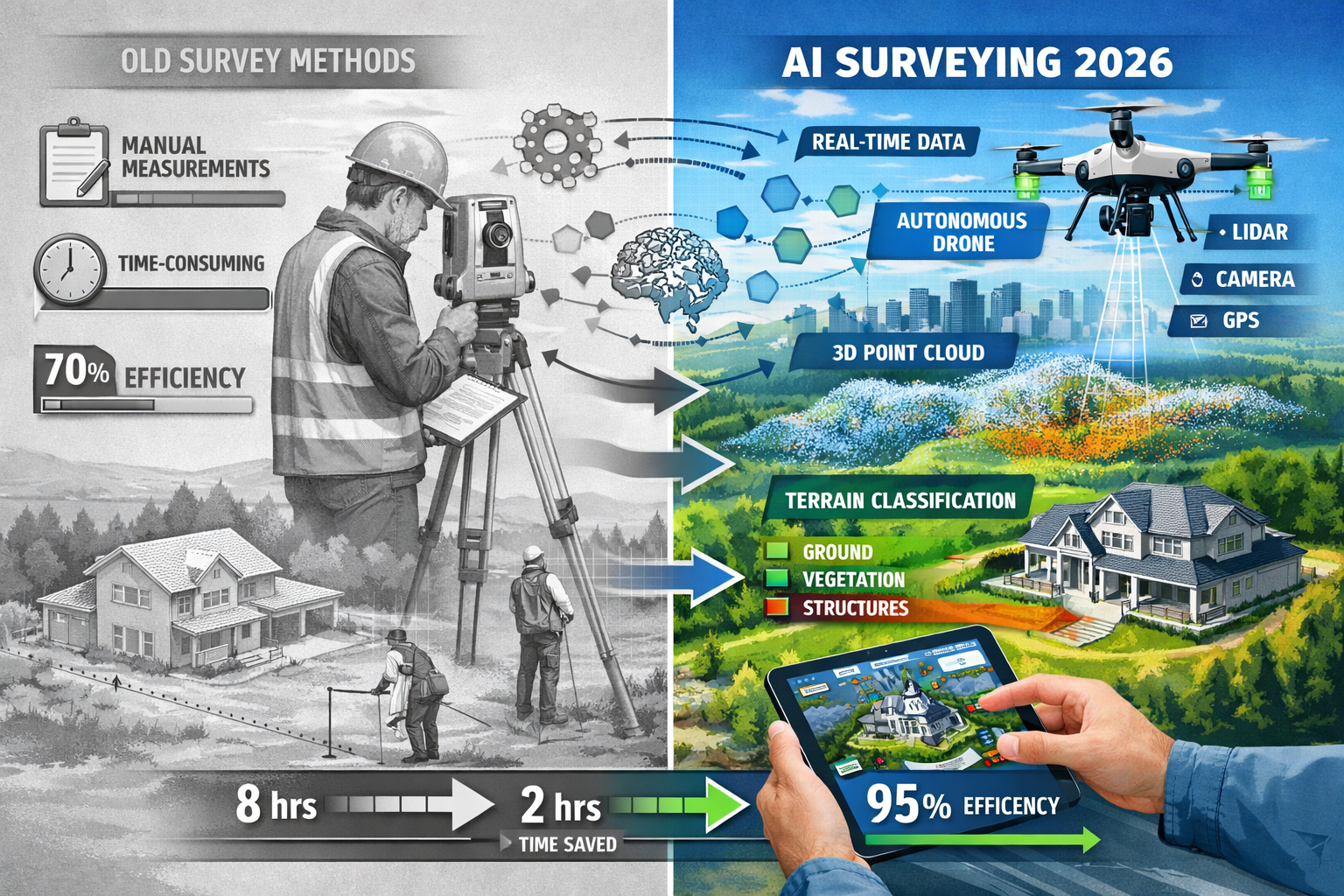
Traditional surveying methods relied heavily on manual measurements, visual inspections, and time-intensive data compilation. While these approaches provided valuable insights, they were inherently limited by human capacity and time constraints. AI-driven precision changes this equation fundamentally.
Modern AI systems are now directly integrated into surveying workflows, instantly classifying terrain types, identifying survey markers, flagging potential anomalies, and generating preliminary surface models.[2] This integration eliminates the manual data sorting that previously consumed significant portions of a surveyor's time, allowing professionals to move directly to analysis and client consultation.
The transformation is particularly evident in property evaluation processes, where AI can rapidly assess multiple data points simultaneously. What previously required a surveyor to manually cross-reference dozens of measurements, photographs, and historical records can now be accomplished through automated systems that highlight discrepancies, suggest areas requiring closer inspection, and provide preliminary risk assessments.
The Technology Stack Behind Modern AI Surveying
Understanding the technological foundation of AI-driven surveying helps appreciate its transformative potential. The modern surveying technology stack typically includes:
🔹 Multi-Sensor Drone Platforms
Advanced drones equipped with LiDAR, high-resolution cameras, thermal imaging, and multispectral sensors provide comprehensive data capture capabilities that deliver clarity and detail previously unavailable.[2]
🔹 Machine Learning Algorithms
AI algorithms convert 2D images from drones or land-based scanners into intricate 3D models, providing comprehensive understanding of spatial relationships—particularly valuable in urban planning and construction contexts.[1]
🔹 Predictive Modeling Systems
Flight paths and data collection strategies are now planned using predictive modeling that optimizes sensor selection, altitude, and angle to achieve optimal readings without constant human intervention.[2]
🔹 Reality Capture Integration
Reality capture has evolved from a specialized service to an integral component of standard property inspection workflows, enabling surveyors to document conditions, track progress visually, and collaborate in real time.[4]
🔹 AI-Assisted Quality Control
Leading surveying firms have integrated AI-assisted quality checks into their review pipelines, enhancing both accuracy and efficiency while reducing the potential for human error.[2]
Real-World Impact: Case Studies from 2026
The practical benefits of AI-driven precision become clear when examining real-world applications:
Case Study 1: Large-Scale Development Survey
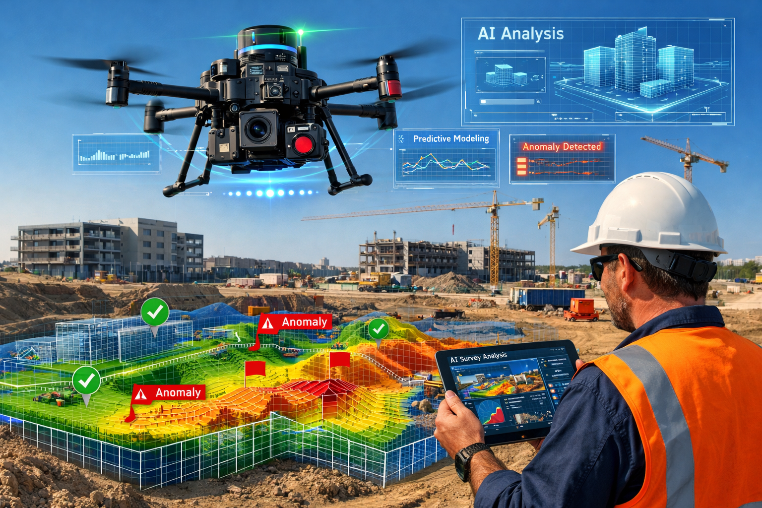
A commercial property development spanning 50 acres traditionally required multiple site visits over several weeks. In 2026, autonomous surveying drones equipped with predictive modeling completed the entire survey in a single day, with AI systems processing the data overnight to produce comprehensive 3D terrain models, identify drainage concerns, and flag potential boundary issues.[2]
Case Study 2: Urban Property Assessment
A surveying firm conducting property assessment work in densely populated urban areas integrated AI document review systems to analyze historical records, planning permissions, and previous survey reports. The AI system identified key clauses and obligations, reducing initial document review time by 60% while maintaining accuracy through human oversight.[3]
Case Study 3: Agricultural Land Survey
For large agricultural properties where traditional surveying methods proved time-prohibitive and costly, autonomous drones with AI-powered terrain classification completed comprehensive surveys that would have previously required weeks of fieldwork, delivering results in days rather than months.[2]
AI-Driven Precision in Property Surveying: Revolutionizing Workflows Through Automation
The automation capabilities enabled by AI represent perhaps the most immediately tangible benefit for surveying professionals and their clients. In 2026, automation has moved beyond simple task completion to encompass sophisticated decision-making and adaptive processes that fundamentally reshape surveying workflows.
Autonomous Drone Technology: The New Standard
Autonomous surveying drones have emerged as game-changers in property surveying, particularly for large-scale agricultural, commercial, and development properties. These sophisticated systems can automatically adjust altitude, angle, and sensor selection to achieve optimal readings without human intervention.[2]
The implications for efficiency are profound. What previously required multiple site visits can now be captured in a single, highly detailed flight, significantly accelerating project delivery timelines.[2] This capability proves especially valuable when conducting building surveys for new developments or assessing properties in challenging terrain.
Key capabilities of 2026 autonomous drone systems include:
| Capability | Traditional Method | AI-Driven Approach | Time Savings |
|---|---|---|---|
| Flight Path Planning | Manual pilot control | Predictive AI optimization | 40-50% |
| Sensor Selection | Pre-set configurations | Adaptive real-time adjustment | 30-40% |
| Data Quality Assurance | Post-flight review | Real-time AI validation | 60-70% |
| Anomaly Detection | Manual inspection | Automated AI flagging | 70-80% |
| Terrain Classification | Post-processing | Instant AI classification | 80-90% |
Streamlined Data Processing and Analysis
Perhaps the most significant workflow revolution comes from AI's ability to process and analyze surveying data in real-time. In 2026, AI systems embedded in core workflows instantly classify terrain, identify markers, flag anomalies, and generate preliminary surface models—replacing manual data sorting that previously required significant time investment.[2]
This transformation enables surveyors to shift their focus from data compilation to interpretation and client consultation. When conducting property inspections, professionals can now spend more time explaining findings, discussing implications, and providing strategic advice rather than managing spreadsheets and compiling measurements.
Integration with Building Information Modeling (BIM)
The integration of AI-enhanced surveying data with Building Information Modeling represents a crucial advancement in 2026. Land surveyors increasingly collaborate with architects, engineers, and construction professionals to integrate geospatial data into BIM models, enhancing project planning and reducing conflicts in construction projects.[2]
This integration creates a seamless flow of information from initial site survey through design, construction, and ongoing property management. AI systems facilitate this integration by automatically formatting surveying data to BIM standards, identifying potential conflicts between survey findings and design specifications, and updating models in real-time as new information becomes available.
For professional surveyor services, this capability enhances value delivery by positioning surveyors as integral partners throughout the entire property development lifecycle rather than one-time service providers.
Reducing Administrative Burden
AI effectively reduces time spent on administrative tasks such as initial document review and data compilation, though interpretation of findings, risk assessment, and provision of tailored advice still require human judgment.[3] This distinction proves critical for understanding AI's role in modern surveying practice.
Recent testing of AI systems for lease and report review showed that AI-generated summaries were effective at identifying key clauses and obligations, though human oversight remains essential for nuanced legal and professional interpretation.[3] This finding aligns with the broader consensus that AI serves as a powerful tool rather than a replacement for professional expertise.
Creating Digital Twins and 3D Models: The Future of Property Visualization
The ability to create accurate, detailed digital twins of properties represents one of the most transformative applications of AI in surveying. In 2026, reality capture and 3D modeling have evolved from specialized services to standard expectations in property transactions and development projects.
From 2D Images to 3D Reality
AI algorithms now seamlessly convert 2D images from drones or land-based scanners into intricate 3D models, providing comprehensive understanding of spatial relationships.[1] This capability proves particularly valuable in urban planning and construction contexts where understanding the relationship between existing structures, proposed developments, and surrounding infrastructure is essential.
The process works through sophisticated photogrammetry and machine learning techniques that:
- Analyze multiple images from different angles and perspectives
- Identify common reference points across images
- Calculate spatial relationships using advanced algorithms
- Generate point clouds representing three-dimensional space
- Create textured 3D models with accurate measurements and proportions
For clients purchasing properties, these 3D models provide unprecedented insight into property conditions. When combined with home survey levels, digital twins enable buyers to virtually explore properties, understand spatial relationships, and identify potential concerns before committing to purchase.
Real-Time Collaboration and Client Engagement
Reality capture has become an integral part of project management workflows in 2026, with AI and machine learning enhancement enabling surveyors to document conditions, track progress visually, and collaborate in real time.[4] This capability transforms the surveyor-client relationship from periodic report delivery to ongoing collaborative engagement.
Benefits of real-time digital collaboration include:
🔸 Immediate visualization of survey findings without waiting for formal reports
🔸 Interactive exploration allowing clients to examine specific areas of concern
🔸 Progress tracking showing changes over time for renovation or construction projects
🔸 Enhanced communication reducing misunderstandings through visual clarity
🔸 Remote accessibility enabling stakeholders to review properties without site visits
Meeting Evolving Client Expectations
Clients in 2026 increasingly expect rich digital deliverables rather than traditional survey products alone.[4] This shift in expectations reflects broader digital transformation across industries and creates both challenges and opportunities for surveying professionals.
Forward-thinking firms have responded by investing in AI-enhanced reality capture capabilities, training staff on digital visualization tools, and restructuring service offerings to emphasize digital deliverables. When conducting property valuations, these firms provide interactive 3D models, annotated virtual tours, and comprehensive digital documentation alongside traditional reports.
Predictive Risk Analysis Through Digital Twins
Beyond visualization, digital twins enable sophisticated predictive risk analysis. AI systems can analyze 3D models to identify potential structural concerns, predict maintenance requirements, and assess long-term property risks with unprecedented accuracy.
For example, AI algorithms can:
- Detect subtle structural deformations that might indicate foundation issues
- Identify drainage patterns that could lead to water damage
- Assess roof condition and predict replacement timelines
- Evaluate energy efficiency through thermal imaging integration
- Flag boundary irregularities that might cause future disputes
This predictive capability proves especially valuable when evaluating structural defects or assessing properties with complex histories. Surveyors can provide clients with forward-looking insights that inform purchase decisions, renovation planning, and long-term property management strategies.
The Human Element: Why Professional Judgment Remains Essential
While AI capabilities continue to advance, the role of professional surveyors has evolved rather than diminished. As of January 29, 2026, RICS (Royal Institution of Chartered Surveyors) consensus confirms that while AI offers valuable capabilities for surveyors, it cannot replace the professional judgment and expertise that qualified surveyors bring to projects.[3]
AI as Tool, Not Replacement
Understanding the relationship between AI and professional expertise proves crucial for both surveyors and clients. AI excels at data processing, pattern recognition, and repetitive task automation. However, interpretation of findings, risk assessment, and provision of tailored advice require human judgment.[3]
This distinction becomes particularly important when conducting comprehensive property inspections where context, local knowledge, and professional experience inform recommendations. An AI system might identify a crack in a wall, but a qualified surveyor understands whether that crack represents normal settling, a minor cosmetic issue, or a symptom of serious structural problems requiring immediate attention.
Areas Where Human Expertise Proves Irreplaceable
Several aspects of surveying practice remain firmly in the domain of human professionals:
🏛️ Regulatory Compliance and Standards
Navigating complex regulatory requirements, understanding local building codes, and ensuring compliance with professional standards require nuanced judgment that AI systems cannot replicate. When advising clients on construction regulations, surveyors draw on extensive training and experience.
⚖️ Legal and Professional Liability
Surveyors carry professional liability for their recommendations and findings. This responsibility requires careful consideration of legal implications, potential disputes, and professional obligations that extend beyond data analysis. Understanding property boundary disputes requires legal knowledge and professional judgment.
🤝 Client Consultation and Communication
Explaining complex technical findings in accessible language, addressing client concerns, and providing strategic advice tailored to individual circumstances remain fundamentally human activities. The ability to understand client needs, ask clarifying questions, and adapt recommendations accordingly cannot be automated.
🎯 Contextual Interpretation
Every property exists within a unique context of local market conditions, historical development patterns, environmental factors, and community characteristics. Professional surveyors synthesize this contextual information with survey findings to provide meaningful recommendations.
The Enhanced Surveyor: Combining AI and Expertise
The most effective surveying practice in 2026 combines AI capabilities with professional expertise. Surveyors who embrace AI tools while maintaining focus on professional judgment deliver superior value to clients through:
- Faster turnaround times enabled by AI data processing
- Enhanced accuracy through AI-assisted quality checks
- Comprehensive analysis combining AI pattern recognition with professional interpretation
- Better client communication using AI-generated visualizations explained by expert professionals
- Proactive risk identification through AI predictive modeling validated by professional assessment
When selecting property surveyors, clients should seek professionals who leverage AI tools while maintaining the expertise and judgment that define quality surveying practice.
Industry Applications: AI Precision Across Property Types
The benefits of AI-driven precision extend across all property types and surveying specializations. Understanding how AI enhances specific applications helps illustrate its transformative potential.
Residential Property Surveys
For residential properties, AI-enhanced surveying provides homebuyers with unprecedented insight into property conditions. When conducting surveys for properties in areas like Hackney, Wandsworth, or Richmond, AI systems can:
- Automatically identify common issues like damp, subsidence indicators, or roof deterioration
- Compare property conditions against databases of similar properties
- Predict maintenance requirements and associated costs
- Generate detailed 3D models for virtual property exploration
- Flag potential concerns for detailed professional inspection
This capability proves especially valuable for first-time buyers who may lack experience in property assessment. Understanding what to do before an RICS home survey becomes easier when AI-enhanced preliminary assessments help buyers understand what to expect.
Commercial Property Assessments
Commercial property surveying benefits significantly from AI's ability to process large volumes of data and identify patterns across extensive properties. For commercial property inspections, AI systems enable:
- Rapid assessment of large building portfolios
- Automated compliance checking against building regulations
- Energy efficiency analysis through thermal imaging integration
- Space utilization optimization through 3D modeling
- Predictive maintenance scheduling based on building systems analysis
Development and Construction Projects
Property development projects leverage AI-driven precision throughout the entire development lifecycle. From initial site surveys through construction monitoring and final completion verification, AI systems provide:
Site Analysis: Comprehensive terrain modeling, drainage assessment, and environmental factor analysis
Construction Monitoring: Progress tracking through regular drone surveys, automated comparison against project timelines, and early identification of deviations from plans
Quality Assurance: AI-assisted verification that construction matches specifications, automated detection of potential defects, and comprehensive documentation for future reference
Agricultural and Rural Properties
Large agricultural and rural properties present unique surveying challenges that AI technology addresses effectively. Autonomous drones equipped with predictive modeling prove particularly valuable for surveying extensive rural properties where traditional methods would be prohibitively time-consuming and expensive.[2]
Applications include boundary verification, land use analysis, drainage system assessment, and environmental impact evaluation.
Overcoming Challenges and Limitations
While AI-driven precision offers tremendous benefits, understanding current limitations and challenges helps set realistic expectations and guide effective implementation.
Data Quality and Input Requirements
AI systems require high-quality input data to produce reliable results. Poor weather conditions, inadequate lighting, or equipment limitations can compromise data quality and affect AI analysis accuracy. Professional surveyors must understand these limitations and know when additional data collection or manual verification is necessary.
Technology Investment and Training
Implementing AI-enhanced surveying capabilities requires significant investment in equipment, software, and training. Smaller surveying practices may face challenges accessing the latest technology, potentially creating competitive disparities within the industry.
Regulatory and Professional Standards Evolution
Professional standards and regulatory frameworks continue evolving to address AI integration in surveying practice. Surveyors must stay current with RICS guidance, insurance requirements, and professional liability considerations related to AI tool usage.
Client Education and Expectation Management
As clients become aware of AI capabilities, managing expectations around what AI can and cannot deliver becomes important. Clear communication about the complementary roles of AI technology and professional expertise helps ensure client satisfaction and appropriate service utilization.
Future Outlook: What's Next for AI in Property Surveying

Looking beyond 2026, several emerging trends suggest continued evolution in AI-driven surveying:
Advanced Predictive Analytics
Future AI systems will likely offer increasingly sophisticated predictive capabilities, forecasting property maintenance needs, market value trends, and long-term risk factors with greater accuracy.
Enhanced Integration Across Property Lifecycle
Expect deeper integration between surveying data, property management systems, maintenance records, and transaction platforms, creating comprehensive digital property histories that enhance decision-making throughout ownership.
Democratization of Technology
As AI tools become more accessible and affordable, smaller surveying practices and individual professionals will gain access to capabilities currently available primarily to larger firms, potentially leveling the competitive landscape.
Regulatory Framework Maturation
Professional bodies like RICS will continue developing comprehensive frameworks governing AI usage in surveying, providing clearer guidance on professional standards, liability considerations, and best practices.
Trimble AI Studio and Custom Solutions
The launch of Trimble AI Studio in early 2026 enables users to build and refine their own AI agents across the Trimble ecosystem,[6] suggesting a future where surveying firms develop customized AI solutions tailored to their specific practice areas and client needs.
Practical Guidance for Property Buyers and Developers
Understanding how AI enhances surveying helps property buyers and developers make informed decisions:
Questions to Ask Your Surveyor
When engaging surveying services, consider asking:
- What AI tools and technologies do you use in your surveying practice?
- How does AI integration affect survey turnaround times and accuracy?
- Will I receive digital deliverables like 3D models or interactive visualizations?
- How do you balance AI capabilities with professional judgment and expertise?
- What quality assurance processes ensure AI-generated findings are accurate?
Leveraging AI-Enhanced Surveys for Negotiation
AI-enhanced surveys provide powerful tools for negotiating purchase prices. Detailed 3D models, predictive maintenance assessments, and comprehensive documentation of property conditions strengthen negotiating positions and support evidence-based price adjustments.
Choosing the Right Survey Level
Understanding survey levels becomes easier when AI-enhanced preliminary assessments help identify properties that may benefit from more comprehensive investigation. AI tools can help surveyors recommend appropriate survey levels based on property characteristics and initial findings.
Conclusion: Embracing the AI-Enhanced Future of Property Surveying
AI-Driven Precision in Property Surveying: Revolutionizing Workflows in 2026 represents a fundamental transformation in how surveying professionals work, how clients engage with surveying services, and how property transactions and developments proceed. The integration of autonomous drones, real-time data processing, 3D digital twins, and predictive analytics has created unprecedented opportunities for efficiency, accuracy, and insight.
Yet this technological revolution hasn't diminished the importance of professional expertise—rather, it has elevated the surveyor's role from data collector to strategic advisor, from report writer to collaborative partner, and from periodic service provider to ongoing resource throughout the property lifecycle.
The most successful surveying practices in 2026 recognize that AI serves as a powerful tool that enhances rather than replaces professional judgment. By combining cutting-edge technology with deep expertise, contextual understanding, and client-focused service, these firms deliver exceptional value that neither AI alone nor traditional methods could achieve.
Actionable Next Steps
For Property Buyers:
- Seek surveyors who leverage AI technology while maintaining professional expertise
- Request digital deliverables like 3D models that enhance property understanding
- Use AI-enhanced survey findings to inform purchase decisions and negotiation strategies
- Consider how predictive analytics can inform long-term ownership planning
For Property Developers:
- Integrate AI-enhanced surveying throughout the development lifecycle
- Leverage digital twins for project planning, monitoring, and marketing
- Collaborate with surveyors who understand BIM integration and digital workflows
- Use predictive modeling to identify and mitigate risks early in development
For Surveying Professionals:
- Invest in AI tools and training that enhance service delivery
- Focus on developing expertise in interpretation, consultation, and strategic advice
- Communicate clearly about how AI enhances rather than replaces professional judgment
- Stay current with evolving professional standards and regulatory frameworks
For All Stakeholders:
- Recognize that effective surveying in 2026 combines technology and expertise
- Embrace digital transformation while valuing professional judgment
- Understand both the capabilities and limitations of AI-enhanced surveying
- Engage with professional surveying services that demonstrate commitment to both technological innovation and professional excellence
The revolution in property surveying driven by AI precision isn't about replacing human professionals with machines—it's about empowering those professionals with tools that enable them to deliver unprecedented value, insight, and service to clients navigating increasingly complex property landscapes. As we move forward through 2026 and beyond, the surveying firms and professionals who successfully integrate AI capabilities while maintaining focus on expertise, judgment, and client service will define the future of the industry.
Whether you're purchasing a home in Chelmsford, developing commercial property in Westminster, or managing an agricultural estate in Brentwood, AI-enhanced surveying provides the precision, efficiency, and insight needed to make informed decisions with confidence. The future of property surveying has arrived—and it combines the best of technological innovation with irreplaceable human expertise.
References
[1] Content Ai Post – https://www.gonzalez-strength.com/content-ai-post/
[2] Future Land Surveying 2026 – https://haller-blanchard.com/future-land-surveying-2026/
[3] How Ai Is Changing Building Surveying Opportunities And Limitations – https://www.eddisons.com/insights/how-ai-is-changing-building-surveying-opportunities-and-limitations
[4] Doubling Down On Digital – https://amerisurv.com/2026/02/01/doubling-down-on-digital/
[6] How Ai Is Changing The Role Of The Surveyor In Aec – https://www.gim-international.com/content/article/how-ai-is-changing-the-role-of-the-surveyor-in-aec