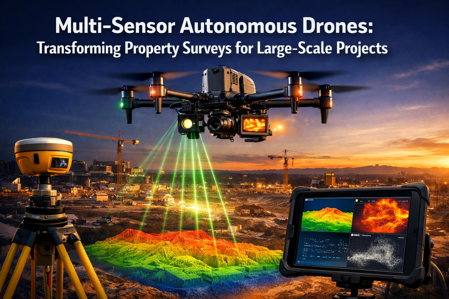
The property surveying industry stands at a pivotal moment in 2026. Traditional surveying methods—requiring teams of professionals spending days or weeks on site with theodolites, total stations, and GPS equipment—are giving way to a revolutionary approach. Multi-Sensor Autonomous Drones: Transforming Property Surveys for Large-Scale Projects represents more than just technological advancement; it signifies a fundamental shift in how professionals capture, analyze, and utilize property data. With integrated sensor arrays that combine LiDAR, photogrammetry, thermal imaging, and multispectral capabilities, these autonomous systems can now complete in hours what previously required weeks of manual labor.
The implications extend far beyond simple efficiency gains. As the surveying industry faces a critical demand-supply gap—with increasing needs driven by development, infrastructure projects, and real estate transactions, yet demographic trends showing unlikely increases in surveying labor—technology-driven solutions have become essential rather than optional.[4] Modern autonomous drones equipped with synchronized multi-sensor suites are filling this gap, delivering unprecedented data quality while simultaneously reducing costs and timeframes.
Key Takeaways
✅ Integrated sensor technology enables drones to capture LiDAR, photogrammetry, thermal, and multispectral data simultaneously in a single flight, eliminating the need for multiple site visits and dramatically reducing survey timelines.
✅ Autonomous flight systems automatically optimize altitude, angle, and sensor selection based on predictive algorithms, ensuring consistent data quality without constant manual intervention.
✅ Significant cost and time savings are achieved through drone surveying, with large-area mapping completed in hours instead of days or weeks, using fewer personnel and less equipment than traditional methods.
✅ Real-time 3D digital twins provide high-fidelity interactive models that update continuously as data is collected, enabling developers and engineers to visualize property conditions and make informed decisions faster.
✅ Diverse applications span agriculture, infrastructure development, real estate assessment, and environmental monitoring, making multi-sensor autonomous drones essential tools across multiple industries in 2026.
Understanding Multi-Sensor Integration in Modern Surveying Drones
The Evolution from Single-Purpose to Multi-Sensor Systems
The journey toward Multi-Sensor Autonomous Drones: Transforming Property Surveys for Large-Scale Projects began with single-purpose aerial platforms. Early commercial drones carried basic cameras for simple visual documentation. However, the limitations became apparent quickly—each data type required separate flights, different equipment, and multiple processing workflows.
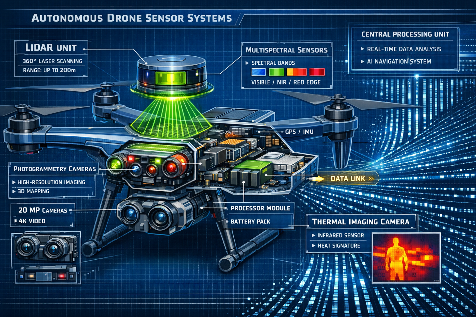
Modern UAV systems have evolved dramatically. Today's platforms carry synchronized multi-sensor suites combining LiDAR, photogrammetry cameras, multispectral sensors, and thermal imaging units, all operating simultaneously to capture data previously requiring multiple site visits.[1] This integration represents a quantum leap in surveying efficiency and data comprehensiveness.
Core Sensor Technologies and Their Functions
LiDAR (Light Detection and Ranging) forms the backbone of precision surveying applications. These sensors emit laser pulses—often hundreds of thousands per second—measuring the time it takes for light to bounce back from surfaces. The result is a detailed point cloud containing millions of precisely georeferenced data points that create accurate 3D representations of terrain and structures.
Photogrammetry cameras capture high-resolution imagery from multiple angles. Advanced processing algorithms analyze overlapping photographs to construct detailed 3D models and orthomosaic maps. Modern systems achieve significantly improved resolution and point density compared to satellite imagery (such as Google Earth), with faster deployment enabling data collection within days rather than weeks or months.[4]
Thermal imaging sensors detect infrared radiation, revealing temperature variations invisible to the human eye. For building condition assessments, thermal cameras identify heat loss, moisture intrusion, insulation defects, and structural anomalies—information critical for comprehensive property evaluations.
Multispectral sensors capture data across specific wavelength bands beyond visible light. In agricultural applications, these sensors measure plant health by analyzing how vegetation reflects different light wavelengths, providing insights into crop stress, irrigation needs, and soil conditions.[3]
Synchronized Data Capture: The Integration Advantage
The true power of multi-sensor autonomous drones emerges through synchronized data capture. Rather than conducting separate surveys for topographic mapping, thermal analysis, and visual documentation, integrated systems collect all data types simultaneously during a single flight operation.
This synchronization offers several critical advantages:
- Temporal consistency: All data reflects the same moment in time, eliminating variables that change between separate surveys
- Geometric alignment: Sensors share positioning systems, ensuring all datasets align precisely in 3D space
- Operational efficiency: One flight operation replaces three or four separate missions
- Cost reduction: Fewer site visits mean lower mobilization costs and less disruption to ongoing operations
- Data correlation: Analysts can directly compare thermal signatures with 3D geometry, or correlate multispectral readings with photographic evidence
The market has responded to this integration trend. Certain photogrammetry and LiDAR technologies now hold 70-90% of the commercial surveying market, with even higher dominance in specific subsectors.[4] This concentration reflects both the maturity of these technologies and their proven value in professional applications.
Autonomous Flight Planning: From Manual Control to Intelligent Systems
The Limitations of Manual Drone Operation
Traditional drone surveying required skilled pilots to manually control flight paths, maintain consistent altitude and speed, and ensure complete coverage of survey areas. This manual approach introduced several challenges:
🔸 Inconsistent data quality from variations in flight parameters
🔸 Human fatigue limiting operational duration and accuracy
🔸 Incomplete coverage with gaps in data collection
🔸 Weather sensitivity requiring experienced judgment for safe operations
🔸 High skill requirements creating workforce bottlenecks
These limitations became particularly problematic for large-scale projects spanning hundreds of acres, where maintaining consistent survey parameters throughout extended operations proved extremely challenging.
Autonomous Navigation and Adaptive Flight Control
Modern autonomous systems have revolutionized flight operations for Multi-Sensor Autonomous Drones: Transforming Property Surveys for Large-Scale Projects. Advanced platforms now automatically adjust altitude, angle, and sensor selection based on predictive modeling algorithms, with flight paths planned for optimal readings without manual intervention.[1]
The autonomous flight process typically follows this workflow:
- Pre-flight mission planning: Operators define survey boundaries, required data types, and quality parameters using desktop software
- Automated path generation: Algorithms calculate optimal flight lines, altitude changes, and sensor configurations
- Obstacle detection and avoidance: Real-time sensors identify and navigate around unexpected obstacles
- Adaptive parameter adjustment: Systems modify flight characteristics based on environmental conditions and data quality feedback
- Automated landing and battery management: Drones return to base stations for battery swaps or charging without human intervention
This automation enables continuous operation across large areas. For extensive property surveys, drones can execute multiple battery cycles autonomously, landing at designated stations for power replenishment before resuming survey operations exactly where they paused.
Predictive Algorithms and Real-Time Optimization
The intelligence behind autonomous flight extends beyond simple waypoint navigation. Modern systems employ sophisticated algorithms that continuously optimize survey parameters:
Terrain-following algorithms maintain consistent ground clearance over varying topography, ensuring uniform data resolution across hills, valleys, and flat areas. This capability proves essential for accurate topographic surveys where elevation changes significantly across the survey area.
Weather-adaptive systems monitor wind speed, precipitation, and lighting conditions, automatically adjusting flight speed, altitude, and camera settings to maintain data quality. Some advanced platforms can even postpone specific survey segments when conditions become unsuitable, resuming automatically when weather improves.
Data quality monitoring provides real-time feedback during flight operations. Systems analyze incoming sensor data, identifying gaps in coverage or areas where quality falls below specified thresholds. The drone automatically resurveys problematic areas before completing the mission, eliminating the need for return visits.
Regulatory Developments Supporting Autonomous Operations
The regulatory landscape continues evolving to accommodate autonomous surveying capabilities. A new regulatory framework to allow surveyors to operate larger drones is expected to be published with an effective date likely in late 2026, expanding operational capabilities.[4] These updated regulations will enable:
- Extended beyond-visual-line-of-sight (BVLOS) operations for large property surveys
- Higher maximum takeoff weights supporting more comprehensive sensor payloads
- Automated traffic management integration for operations in complex airspace
- Standardized autonomous operation protocols ensuring safety and consistency
These regulatory advances will further accelerate adoption of autonomous surveying systems, particularly for large-scale infrastructure and development projects where survey areas extend beyond visual range.
Applications Across Industries: From Agriculture to Development
Agricultural Land Assessment and Crop Management
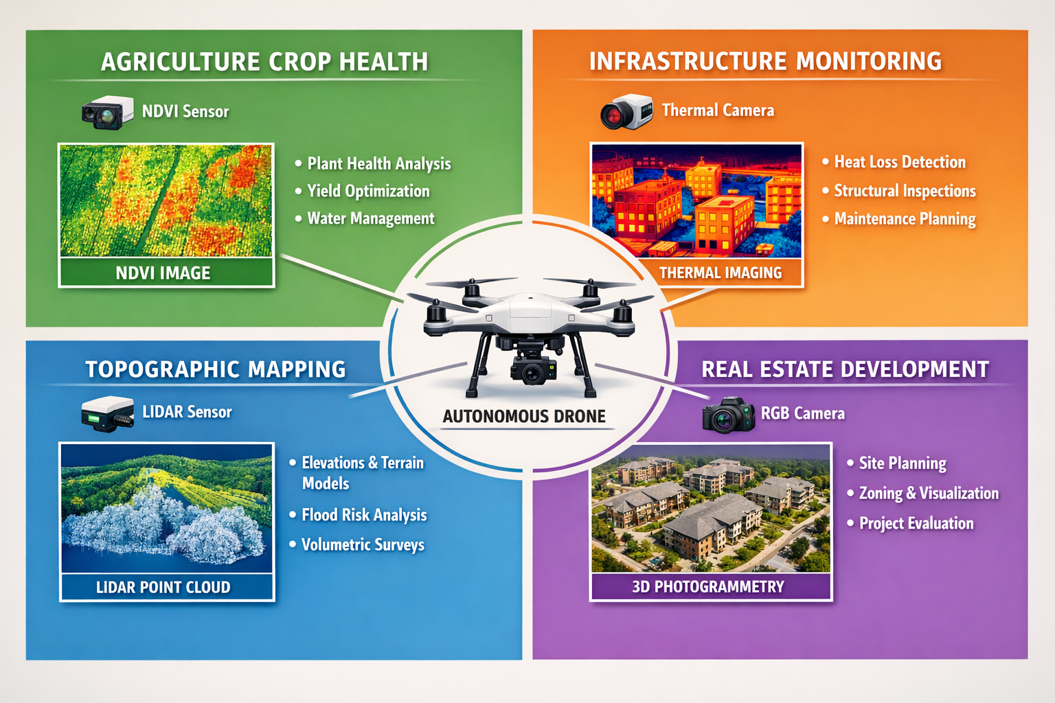
Agriculture represents one of the most data-intensive applications for multi-sensor autonomous drones. Farmers and agricultural managers use these systems to assess crop health, irrigation needs, and land analysis to optimize farming operations.[3]
Multispectral imaging provides the foundation for precision agriculture. By capturing data in specific wavelength bands—including near-infrared and red-edge spectrums—drones calculate vegetation indices that quantify plant health. The Normalized Difference Vegetation Index (NDVI) reveals areas of crop stress before visible symptoms appear, enabling targeted interventions that prevent yield losses.
Thermal sensors identify irrigation inefficiencies by detecting temperature variations across fields. Well-watered crops maintain cooler canopy temperatures through evapotranspiration, while water-stressed plants show elevated temperatures. This data enables precision irrigation, delivering water only where needed and conserving this critical resource.
LiDAR systems map subtle elevation changes affecting water drainage and accumulation. By understanding how water flows across agricultural land, farmers can optimize field grading, install targeted drainage systems, and prevent crop damage from standing water.
The autonomous capability proves particularly valuable in agriculture, where large areas require frequent monitoring throughout growing seasons. Drones can execute scheduled survey flights without operator intervention, providing consistent temporal data that reveals crop development patterns and enables predictive yield modeling.
Infrastructure Development and Construction Monitoring
Large-scale infrastructure projects—highways, railways, utilities, and commercial developments—generate enormous surveying demands throughout their lifecycles. Multi-Sensor Autonomous Drones: Transforming Property Surveys for Large-Scale Projects have become indispensable tools for project managers, engineers, and contractors.
Pre-construction site assessment establishes baseline conditions before ground-breaking. Integrated sensor suites capture:
- Detailed topography from LiDAR point clouds for grading calculations
- Visual documentation through high-resolution photogrammetry
- Environmental conditions via thermal and multispectral imaging
- Volumetric measurements for earthwork planning and cost estimation
Construction progress monitoring leverages autonomous flight capabilities for consistent temporal surveys. Weekly or monthly flights following identical paths enable direct comparison of site conditions, revealing:
- Earthwork volumes moved and remaining
- Construction progress against project schedules
- Potential drainage or grading issues requiring correction
- Safety hazards or non-compliant work requiring attention
Post-construction verification documents completed work and identifies defects requiring remediation. Thermal imaging proves particularly valuable for detecting issues in buried utilities, pavement compaction, and building envelope performance.
The time savings prove substantial. Drone surveys can complete large-area mapping in hours versus days or weeks required by traditional ground-based surveying, substantially accelerating decision-making and project progression.[3] This speed enables more frequent monitoring, catching problems early when corrections remain inexpensive.
Real Estate Development and Property Assessment
The real estate sector has embraced multi-sensor drone technology for both large-scale development projects and individual property assessments. These systems complement traditional property surveys by providing comprehensive aerial perspectives and specialized data types.
Development site evaluation for residential or commercial projects benefits from integrated sensor capabilities:
- Topographic mapping identifies optimal building locations and infrastructure routing
- Thermal surveys reveal soil moisture patterns affecting foundation design
- Multispectral analysis assesses vegetation health and environmental features
- Photogrammetry creates accurate base maps for planning and permitting
Property condition assessments extend beyond what ground-based inspections can achieve. Thermal imaging detects roof leaks, insulation deficiencies, and moisture intrusion in building envelopes—issues that might escape visual inspection but significantly impact property value and buyer negotiations. This technology complements traditional building surveys by providing data on otherwise inaccessible building elements.
Portfolio management for large property holdings benefits from autonomous survey capabilities. Real estate investment trusts (REITs) and institutional investors use scheduled drone surveys to monitor property conditions across geographically dispersed portfolios, identifying maintenance needs before they escalate into expensive repairs.
The enhanced data quality proves particularly valuable. Drone surveys deliver precise locational data plus access to difficult terrain and diverse data types previously unavailable or difficult to obtain through ground surveys.[3] For properties with challenging access—steep slopes, dense vegetation, or hazardous conditions—drones safely capture data that would be dangerous or impossible to collect through traditional methods.
Environmental Monitoring and Conservation
Environmental applications leverage the comprehensive data collection capabilities of multi-sensor autonomous drones for ecosystem assessment and conservation planning.
Habitat mapping combines photogrammetry for detailed vegetation structure with multispectral imaging for species identification and health assessment. Conservation organizations use this data to track habitat changes over time, assess restoration project success, and identify areas requiring intervention.
Wetland delineation benefits from integrated thermal and multispectral sensors. Thermal imaging reveals moisture patterns and water flow paths, while multispectral data identifies vegetation types characteristic of wetland ecosystems. This combination provides accurate wetland boundaries essential for regulatory compliance and conservation planning.
Erosion monitoring uses temporal LiDAR surveys to measure volumetric changes in soil and sediment. Coastal properties, riverbanks, and construction sites benefit from precise erosion rate calculations that inform stabilization strategies and regulatory reporting.
The autonomous capabilities enable long-term monitoring programs with consistent methodology. Drones execute identical flight paths at regular intervals, ensuring temporal datasets remain directly comparable for trend analysis and change detection.
The Technology Behind Real-Time 3D Digital Twins

From Point Clouds to Interactive Models
One of the most transformative aspects of Multi-Sensor Autonomous Drones: Transforming Property Surveys for Large-Scale Projects is the ability to create high-fidelity, interactive 3D models that update continuously as new data is collected, allowing developers and engineers to visualize land behavior under various conditions.[1]
The process begins with point cloud generation from LiDAR and photogrammetry data. Modern systems capture millions of georeferenced points per flight, each containing:
- Precise 3D coordinates (X, Y, Z positions)
- Color information from photographic imagery
- Intensity values reflecting surface reflectivity
- Classification data identifying ground, vegetation, buildings, and other features
Advanced processing algorithms transform these point clouds into mesh models—continuous surfaces representing terrain and structures. Texture mapping applies high-resolution photography to mesh surfaces, creating photorealistic 3D models that accurately represent visual appearance alongside geometric precision.
Continuous Updates and Temporal Analysis
Unlike static surveys that provide single-moment snapshots, modern digital twin platforms support continuous updating as new survey data becomes available. This capability proves invaluable for active construction sites and dynamic environments.
Automated change detection algorithms compare sequential surveys, highlighting areas where conditions have changed. For construction projects, this reveals:
- Progress visualization: Direct comparison of current conditions against design models and previous surveys
- Volumetric calculations: Precise measurements of material moved, stockpile volumes, and earthwork quantities
- Quality control: Identification of work deviating from specifications
- Safety monitoring: Detection of unstable slopes, erosion, or other hazards
Temporal visualization enables users to "play back" site evolution, watching construction progress or environmental changes unfold over weeks, months, or years. This capability supports project documentation, dispute resolution, and lessons-learned analysis for future projects.
Integration with Design and Analysis Software
Digital twins created from drone survey data integrate seamlessly with professional design and analysis platforms. Building Information Modeling (BIM) software imports point clouds and mesh models, enabling architects and engineers to:
- Design structures within accurate existing conditions
- Verify as-built construction against design intent
- Plan renovations and additions with precise dimensional data
- Coordinate multiple design disciplines in shared 3D environments
Geographic Information Systems (GIS) platforms incorporate drone-derived data for spatial analysis and planning. Urban planners, environmental consultants, and infrastructure designers use these integrated datasets to analyze site suitability, optimize layouts, and assess environmental impacts. The availability of GIS-integrated data enhances decision-making across multiple disciplines.
Engineering analysis software imports terrain models for drainage design, slope stability analysis, and infrastructure planning. Civil engineers use drone-derived topography to model water flow, design grading plans, and optimize road alignments—all with confidence in the underlying data accuracy.
Collaborative Decision-Making and Stakeholder Communication
Digital twins serve as powerful communication tools, making complex survey data accessible to non-technical stakeholders. Project owners, investors, regulatory officials, and community members can explore interactive 3D models through web browsers, gaining intuitive understanding of project sites and proposed developments.
Virtual site visits enable remote stakeholders to explore properties without physical travel. During 2026, as remote collaboration remains common, this capability reduces travel costs and time while ensuring all parties share common understanding of site conditions.
Annotation and markup tools allow team members to identify issues, ask questions, and propose solutions directly within the 3D environment. These annotations remain linked to specific locations, ensuring clear communication about spatial concerns.
Scenario modeling overlays proposed designs onto existing conditions, enabling stakeholders to visualize development impacts before construction begins. This capability supports informed decision-making and can reduce opposition to projects by clearly communicating design intent and site integration.
Cost-Benefit Analysis: Comparing Traditional and Drone-Based Surveying
Direct Cost Comparisons
Understanding the financial implications of Multi-Sensor Autonomous Drones: Transforming Property Surveys for Large-Scale Projects requires examining both initial investments and operational costs compared to traditional surveying methods.
Traditional surveying costs for large-scale projects typically include:
| Cost Category | Traditional Survey | Multi-Sensor Drone Survey |
|---|---|---|
| Personnel | 3-5 surveyors for multiple days | 1-2 operators for hours |
| Equipment | Total stations, GPS, levels | Drone system, processing software |
| Mobilization | Multiple site visits | Single or few site visits |
| Data Processing | Manual calculations, CAD drafting | Automated processing, digital outputs |
| Timeline | Days to weeks | Hours to days |
| Coverage | Limited by accessibility | Comprehensive including difficult areas |
Drone surveying achieves comparable results with fewer personnel and less equipment than traditional methods, generating significant cost savings despite initial technology investment.[3] For a 100-acre development site, traditional surveying might require a team of four surveyors working for two weeks, while a drone system could capture equivalent data in 6-8 hours of flight time spread across 2-3 days.
Indirect Benefits and Value Creation
Beyond direct cost savings, multi-sensor autonomous drones create value through capabilities unavailable or impractical with traditional methods:
Accelerated project timelines translate directly to financial benefits. In development projects where holding costs, financing expenses, and opportunity costs accumulate daily, reducing survey duration from weeks to days can save substantial money. Faster data availability enables earlier decision-making, shortening overall project schedules.
Enhanced data quality reduces risk and improves outcomes. The comprehensive datasets from integrated sensors reveal conditions that might escape traditional surveys, preventing costly surprises during construction. Thermal imaging might identify subsurface moisture requiring foundation design modifications—an issue discovered during surveying rather than after construction begins.
Reduced safety risks eliminate expenses associated with accidents and injuries. Surveying hazardous sites—steep slopes, unstable terrain, contaminated areas—from the air keeps personnel safe while capturing necessary data. Insurance costs and liability exposure decrease accordingly.
Improved stakeholder communication through digital twins and visualizations can accelerate approvals and reduce project opposition. The ability to clearly demonstrate site conditions and design integration to regulatory agencies, neighbors, and community groups can prevent costly delays and design modifications.
Return on Investment Considerations
For surveying firms and property developers evaluating drone technology adoption, return on investment (ROI) calculations must consider both quantitative and qualitative factors.
Initial investment for professional multi-sensor drone systems ranges from $25,000 for entry-level platforms to $200,000+ for advanced systems with comprehensive sensor suites. Additional costs include:
- Processing software licenses ($2,000-$15,000 annually)
- Operator training and certification ($1,000-$5,000 per operator)
- Insurance coverage ($1,500-$5,000 annually)
- Maintenance and replacement parts (10-15% of system cost annually)
Operational savings accumulate with each project. A surveying firm conducting 20 large-scale surveys annually might reduce field time by 70% and personnel requirements by 60%, creating savings that can recover initial investment within 12-24 months.
Competitive advantages provide less tangible but equally important benefits. Firms offering drone surveying capabilities can:
- Win projects requiring rapid turnaround times
- Differentiate services through enhanced deliverables
- Expand service offerings to new market segments
- Command premium pricing for advanced capabilities
Organizations evaluating adoption should consider their project pipeline, typical survey requirements, and competitive landscape when calculating expected ROI.
Addressing Challenges and Limitations
Weather and Environmental Constraints
Despite their capabilities, multi-sensor autonomous drones face operational limitations that users must understand and accommodate.
Weather sensitivity affects both flight safety and data quality. Strong winds challenge stability and battery life, while precipitation can damage electronics and degrade sensor performance. Fog and low clouds prevent safe operations and reduce visibility for photogrammetry. Most professional systems specify operational limits:
- Wind speeds below 20-25 mph
- No precipitation during flight operations
- Minimum visibility distances of 3-5 miles
- Temperature ranges typically -10°C to 40°C
Lighting conditions significantly impact photogrammetry quality. Bright, even lighting produces optimal results, while harsh shadows, extreme contrast, or low light create challenges for image processing. Most surveys schedule flights during mid-morning or mid-afternoon when sun angles minimize shadows while providing adequate illumination.
Electromagnetic interference from power lines, radio towers, and other sources can disrupt GPS signals and communication links. Survey planning must identify potential interference sources and maintain adequate clearance or implement alternative positioning systems.
Regulatory Compliance and Airspace Restrictions
Operating drones for commercial surveying requires compliance with aviation regulations that vary by jurisdiction but generally include:
Operator certification requiring knowledge testing and demonstration of aeronautical knowledge, drone operating procedures, and safety protocols. In many jurisdictions, commercial operators must hold specific licenses or certifications beyond recreational drone operation permissions.
Airspace authorization for operations in controlled airspace near airports or other restricted areas. The authorization process can require advance notice ranging from days to weeks, potentially delaying time-sensitive surveys.
Privacy and data protection considerations when surveying properties near residences or capturing imagery that might reveal sensitive information. Operators must understand and comply with privacy laws and obtain necessary permissions for overflights.
Insurance requirements for commercial operations typically mandate liability coverage protecting against property damage, personal injury, and privacy violations. Coverage costs vary based on operational scope and risk profile.
The anticipated regulatory framework updates in late 2026[4] should streamline some compliance requirements while potentially introducing new standards for autonomous operations and larger platforms.
Technical Expertise and Training Requirements
Effective deployment of Multi-Sensor Autonomous Drones: Transforming Property Surveys for Large-Scale Projects requires specialized knowledge spanning multiple disciplines:
Aviation skills for safe flight operations, emergency procedures, and weather assessment remain essential even with autonomous systems. Operators must understand aerodynamics, navigation, and risk management.
Surveying expertise ensures proper ground control point placement, coordinate system selection, and quality verification. Understanding surveying principles prevents errors that automated systems cannot detect.
Data processing proficiency with specialized software for point cloud processing, photogrammetry, and model generation. These complex tools require training and experience to produce professional-quality deliverables.
Sensor technology knowledge enables operators to select appropriate sensors for specific applications, optimize sensor settings, and troubleshoot data quality issues.
Organizations adopting drone surveying must invest in training or hire personnel with these diverse skill sets. The learning curve can extend 6-12 months before operators achieve proficiency across all required competencies.
Data Management and Processing Infrastructure
The comprehensive data capture capabilities of multi-sensor systems create substantial data management challenges:
Storage requirements can reach hundreds of gigabytes per survey for large projects with multiple sensor types. Organizations need robust storage infrastructure with backup and archival capabilities.
Processing demands require powerful computers with high-performance processors, substantial RAM (32GB+), and dedicated graphics cards. Processing complex point clouds and photogrammetry datasets can require hours or days of computation time.
Workflow management becomes critical when handling multiple concurrent projects. Organizations need systems for tracking data from capture through processing to final deliverable, ensuring quality control and meeting client deadlines.
Long-term archiving for projects requiring future reference or legal documentation demands organized storage systems with metadata enabling retrieval of specific surveys from potentially thousands of datasets.
These infrastructure requirements represent ongoing operational costs that organizations must budget alongside equipment and personnel expenses.
Future Developments and Industry Trends
Artificial Intelligence and Machine Learning Integration
The next evolution of Multi-Sensor Autonomous Drones: Transforming Property Surveys for Large-Scale Projects involves deeper integration of artificial intelligence and machine learning capabilities:
Automated feature extraction will enable systems to automatically identify and classify objects within survey data—buildings, vegetation types, infrastructure elements, and site features—without manual annotation. This capability will dramatically reduce processing time and enable rapid analysis of large datasets.
Predictive maintenance algorithms will monitor drone system health, predicting component failures before they occur and optimizing maintenance schedules to prevent operational disruptions.
Intelligent survey planning will leverage historical data and machine learning to optimize flight parameters for specific site conditions and survey objectives, continuously improving efficiency through experience.
Anomaly detection will automatically identify unusual conditions requiring human review—potential structural defects, environmental concerns, or safety hazards—flagging these issues for expert evaluation.
Enhanced Sensor Capabilities
Sensor technology continues advancing, with emerging capabilities including:
Hyperspectral imaging capturing data across dozens or hundreds of narrow wavelength bands, enabling detailed material identification and condition assessment beyond current multispectral capabilities.
Ground-penetrating radar (GPR) integration for subsurface feature detection, revealing buried utilities, archaeological features, and soil conditions without excavation.
Gas detection sensors for environmental monitoring, leak detection in industrial facilities, and safety assessment in hazardous environments.
Acoustic sensors for noise mapping, wildlife monitoring, and structural assessment through sound analysis.
These expanding sensor capabilities will enable new applications and provide increasingly comprehensive site characterization from single survey flights.
Swarm Technology and Coordinated Operations
Drone swarms—multiple autonomous drones operating in coordination—represent an emerging capability for large-scale surveying:
Parallel data collection with multiple drones simultaneously surveying different portions of large sites will dramatically reduce survey duration for extensive properties.
Specialized sensor distribution will enable each drone in a swarm to carry different sensors, collectively capturing comprehensive multi-sensor data while optimizing individual payload weights.
Redundancy and reliability through swarm operations will ensure survey completion even if individual drones experience technical issues or battery depletion.
Dynamic task allocation will enable swarms to automatically redistribute survey responsibilities based on changing conditions, battery levels, or data quality requirements.
Integration with Broader Digital Infrastructure
Survey data from autonomous drones will increasingly integrate with broader digital infrastructure:
Smart city platforms will incorporate regular drone surveys for infrastructure monitoring, urban planning, and emergency response coordination.
Digital permitting systems will accept drone survey data directly, automating compliance verification and accelerating approval processes.
Real-time monitoring networks will combine drone surveys with fixed sensors, satellite imagery, and ground-based monitoring for comprehensive site awareness.
Blockchain verification may provide immutable records of survey data provenance, timestamps, and processing history, supporting legal and regulatory requirements.
These integrations will embed drone surveying within larger digital ecosystems, amplifying value through data sharing and coordinated analysis.
Implementing Multi-Sensor Drone Surveying: A Practical Roadmap
Assessment and Planning Phase
Organizations considering adoption of Multi-Sensor Autonomous Drones: Transforming Property Surveys for Large-Scale Projects should follow a structured implementation approach:
Needs assessment begins with analyzing current surveying workflows, identifying pain points, and defining specific objectives for drone technology adoption. Questions to address include:
- What types of surveys do we conduct most frequently?
- What are our typical project sizes and complexities?
- Where do current methods create bottlenecks or limitations?
- What data types would enhance our deliverables?
- What are our budget constraints for initial investment and ongoing operations?
Use case prioritization identifies applications offering the highest return on investment. Organizations might start with specific project types—such as large development sites or infrastructure monitoring—before expanding to broader applications.
Regulatory research ensures understanding of local aviation regulations, certification requirements, and operational restrictions. Engaging with aviation authorities early prevents compliance surprises during implementation.
Budget development encompasses all cost categories: equipment acquisition, software licenses, training, insurance, infrastructure, and ongoing operational expenses. Realistic budgeting prevents mid-implementation funding shortfalls.
Technology Selection and Acquisition
Platform selection requires matching drone capabilities to identified needs:
- Fixed-wing drones offer extended flight times and coverage for large areas but require more space for takeoff and landing
- Multi-rotor drones provide vertical takeoff/landing and hovering capabilities ideal for detailed inspections but with shorter flight times
- Hybrid platforms combine advantages of both approaches for maximum versatility
Sensor configuration should align with primary applications. Organizations focusing on topographic surveying might prioritize high-quality LiDAR, while those emphasizing building condition assessments might invest more heavily in thermal imaging capabilities.
Software ecosystem selection impacts long-term workflows. Consider:
- Processing software compatibility with chosen sensors
- Integration capabilities with existing CAD, BIM, and GIS platforms
- Learning curve and training requirements
- Licensing models (perpetual vs. subscription)
- Vendor support and update frequency
Vendor evaluation should assess not only product capabilities but also company stability, support quality, training resources, and user community strength.
Training and Skill Development
Pilot certification through official aviation authority programs provides foundational knowledge and legal authorization for commercial operations. Most programs require 20-40 hours of study and successful examination.
Manufacturer training on specific drone platforms and sensors ensures operators understand equipment capabilities, limitations, and proper operating procedures. Many manufacturers offer multi-day training programs at their facilities or customer sites.
Software training for data processing applications represents a substantial investment. Processing software complexity requires structured training—often 40-80 hours of instruction and practice—to achieve proficiency.
Ongoing education through industry conferences, webinars, and professional organizations keeps teams current with evolving best practices, regulatory changes, and technological advances.
Workflow Integration and Process Development
Standard operating procedures (SOPs) document consistent approaches for mission planning, flight operations, data processing, quality control, and deliverable production. Well-developed SOPs ensure consistency across different operators and projects.
Quality assurance protocols establish verification steps ensuring data accuracy and completeness. These might include:
- Ground control point measurement and verification procedures
- Data processing checkpoints and review stages
- Accuracy testing against known reference data
- Peer review of final deliverables
Project management systems track surveys from initial request through final delivery, ensuring deadlines are met and client requirements are fulfilled.
Client communication processes explain drone surveying capabilities, deliverable formats, and timelines to clients unfamiliar with the technology. Educational materials and sample deliverables help set appropriate expectations.
Performance Monitoring and Continuous Improvement
Metrics tracking enables organizations to quantify benefits and identify improvement opportunities:
- Survey completion time compared to traditional methods
- Cost per acre or per project compared to previous approaches
- Data quality metrics (accuracy, completeness, resolution)
- Client satisfaction and repeat business rates
- Safety incidents and near-misses
Lessons learned reviews after each project capture insights for process improvement. Regular team meetings discuss challenges encountered and solutions developed, building organizational knowledge.
Technology refresh planning anticipates equipment lifecycle and budgets for periodic upgrades as sensor capabilities advance and platforms reach end-of-service life.
Conclusion: Embracing the Future of Property Surveying
Multi-Sensor Autonomous Drones: Transforming Property Surveys for Large-Scale Projects represents far more than incremental improvement over traditional surveying methods. This technology fundamentally reimagines how professionals capture, analyze, and utilize property data—delivering unprecedented speed, comprehensive datasets, and cost efficiency that addresses the critical labor shortage facing the surveying industry in 2026.
The integration of LiDAR, photogrammetry, thermal imaging, and multispectral sensors into autonomous platforms enables single-flight data capture that previously required multiple site visits with different equipment. Real-time 3D digital twins provide interactive visualizations that transform stakeholder communication and decision-making. Applications spanning agriculture, infrastructure development, real estate assessment, and environmental monitoring demonstrate the versatility and value of this technology across diverse industries.
While challenges remain—weather limitations, regulatory compliance requirements, technical expertise needs, and data management demands—the benefits substantially outweigh these constraints for most large-scale surveying applications. Organizations that strategically implement multi-sensor drone technology position themselves to meet growing market demands while traditional competitors struggle with labor shortages and outdated methodologies.
Actionable Next Steps
For surveying professionals considering drone technology adoption:
- Conduct a comprehensive needs assessment analyzing your current project portfolio and identifying applications where drone surveying offers the greatest value
- Develop a realistic implementation budget encompassing equipment, software, training, insurance, and infrastructure costs
- Research regulatory requirements in your jurisdiction and begin the certification process for commercial drone operations
- Start with focused pilot projects in specific application areas before expanding to broader deployment
- Invest in thorough training for operators, ensuring they develop proficiency across aviation, surveying, and data processing disciplines
For property developers and project managers:
- Evaluate current surveying vendors for drone capabilities and consider how these technologies might accelerate your projects
- Request drone survey proposals for upcoming large-scale projects to compare costs, timelines, and deliverables against traditional methods
- Explore digital twin capabilities for construction monitoring and stakeholder communication on active projects
- Consider in-house capabilities if your organization conducts frequent surveys across multiple properties
For industry stakeholders broadly:
- Stay informed about regulatory developments, particularly the anticipated late-2026 framework updates enabling larger drone operations
- Participate in industry organizations focused on drone surveying to share best practices and influence standards development
- Advocate for regulatory frameworks that enable beneficial applications while ensuring safety and privacy protection
- Explore emerging technologies including AI integration, advanced sensors, and swarm capabilities that will shape the next evolution of surveying
The transformation of property surveying through multi-sensor autonomous drones is not a future possibility—it is the present reality in 2026. Organizations that embrace this technology today position themselves for success in an industry where traditional approaches increasingly cannot meet market demands. The question is no longer whether to adopt drone surveying, but how quickly and strategically to implement these capabilities for competitive advantage.
Whether conducting detailed property assessments, monitoring large infrastructure projects, or managing agricultural operations, multi-sensor autonomous drones deliver the comprehensive data, operational efficiency, and cost savings that define modern professional surveying. The future of property surveying has arrived—and it flies.
References
[1] Future Land Surveying 2026 – https://haller-blanchard.com/future-land-surveying-2026/
[2] Autonomous Drones And Multi Sensor Technology The Game Changer For Large Scale Property Surveys – https://nottinghillsurveyors.com/blog/autonomous-drones-and-multi-sensor-technology-the-game-changer-for-large-scale-property-surveys
[3] Drone Surveying – https://uavcoach.com/drone-surveying/
[4] Watch – https://www.youtube.com/watch?v=CSTodaZb4Vc