
The construction industry stands at a pivotal moment in 2026. As infrastructure projects grow more complex and stakeholder demands intensify, land surveyors are no longer just measuring ground—they're building the digital foundations that make modern construction possible. BIM Integration for Land Surveyors: Seamless Collaboration in Construction Projects represents the evolution from traditional surveying methods to sophisticated digital workflows that connect geospatial data directly with collaborative building models. This transformation isn't just changing how surveyors work; it's redefining their essential role in construction success.
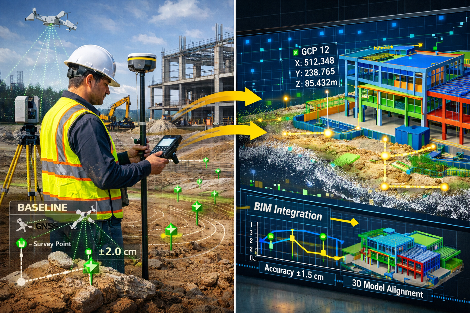
Gone are the days when survey data arrived on paper plans, requiring manual translation into design software. Today's surveyors capture spatial information in formats that feed seamlessly into Building Information Modeling (BIM) platforms, creating virtual foundations before a single shovel touches soil.[5] This integration minimizes costly conflicts, accelerates project timelines, and positions surveyors as critical partners throughout the entire construction lifecycle—not just at the beginning.
Key Takeaways
- Surveyors provide the virtual foundations for BIM models by delivering accurate geospatial data that forms the basis for all subsequent design and construction work[4]
- BIM integration delivers measurable results: projects combining BIM with Value Engineering demonstrate 10% cost and time savings while improving overall quality[3]
- Continuous involvement throughout construction means surveyors monitor baseline changes and integrate real-time data into BIM models as structures emerge[4]
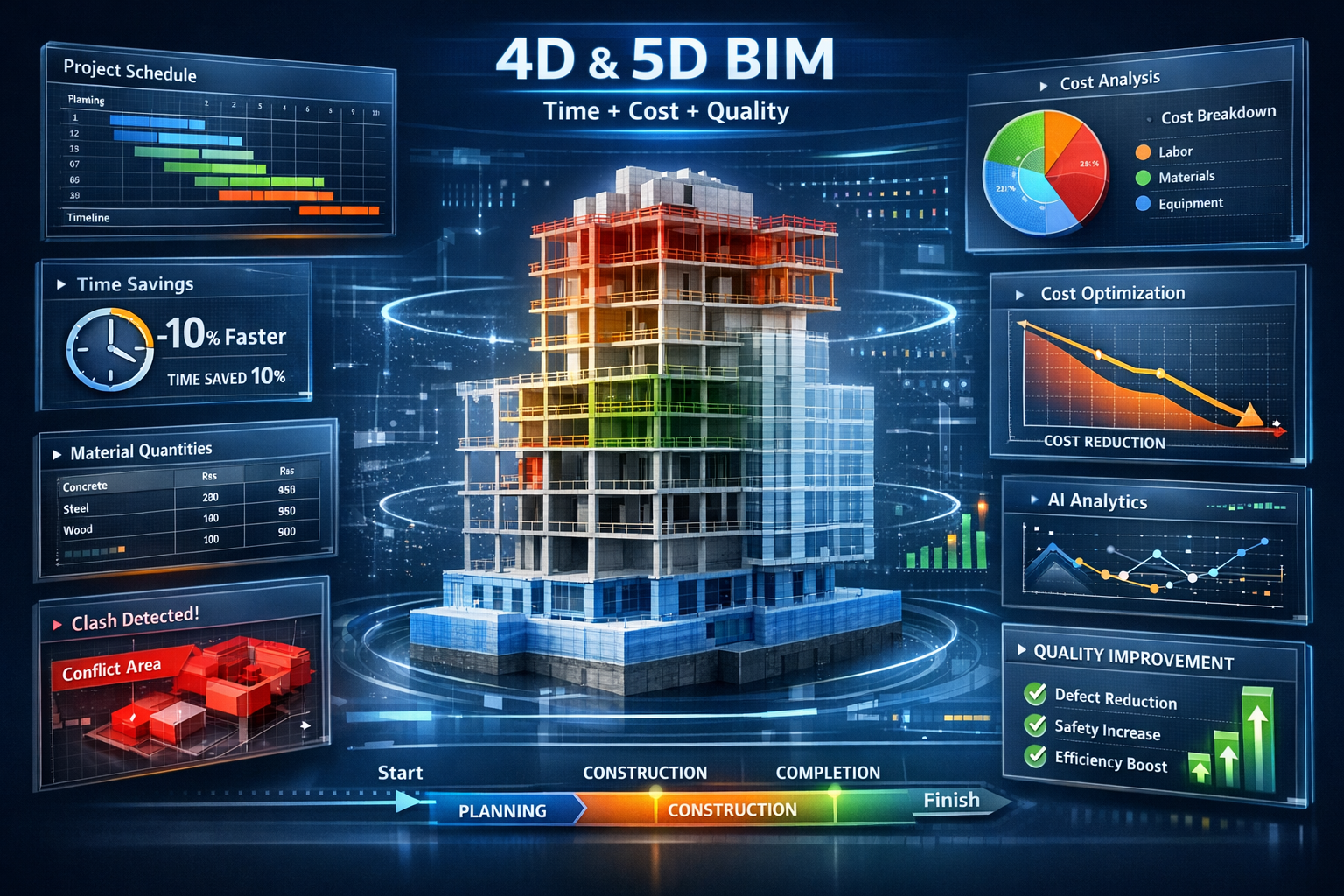
- Advanced capabilities like 4D and 5D BIM enable dynamic scheduling simulation and rapid material quantity calculations for enhanced cost control[3]
- Growing demand in 2026 for surveyors with BIM expertise as infrastructure projects increasingly require seamless digital collaboration[1]
Understanding BIM Integration for Land Surveyors: Seamless Collaboration in Construction Projects
What BIM Integration Means for Modern Surveyors
Building Information Modeling has transformed from a design tool into a comprehensive digital ecosystem that encompasses every construction phase. For land surveyors, BIM integration specifically means capturing spatial data in formats that seamlessly feed into collaborative digital environments where architects, engineers, contractors, and project managers work simultaneously.[5]
This shift fundamentally changes the surveyor's deliverables. Instead of providing static CAD drawings or PDF reports, modern surveyors deliver:
- Point cloud data from laser scanning that populates BIM models with as-built conditions
- Georeferenced 3D models that establish precise coordinate systems for design alignment
- Topographic surfaces compatible with BIM platforms like Revit, ArchiCAD, and Navisworks
- Real-time monitoring data that updates digital twins throughout construction
- Quality control measurements that verify construction accuracy against BIM specifications
The integration creates what industry professionals call "virtual foundations"—digital representations of existing site conditions that must be accurate before design work begins.[4] When finding a surveyor for BIM-enabled projects, this capability has become essential.
The Surveyor's Evolving Role in the BIM Ecosystem
Surveyors bridge the critical gap between physical land conditions and virtual planning processes within BIM systems.[4] This role extends far beyond initial site surveys. Throughout 2026, successful surveyors maintain active involvement across multiple project stages:
Pre-Construction Phase:
- Establishing control networks and coordinate systems
- Capturing existing conditions through terrestrial and aerial surveys
- Creating accurate base models for design teams
- Identifying potential site constraints and opportunities
Design Phase:
- Validating design assumptions against real-world measurements
- Providing updated surveys as design evolves
- Participating in clash detection reviews
- Ensuring constructability from a geospatial perspective
Construction Phase:
- Setting out building positions and elevations
- Monitoring structural movements and settlements
- Performing as-built surveys for continuous BIM updates
- Verifying construction accuracy against design intent
Post-Construction Phase:
- Delivering final as-built BIM models
- Supporting facility management with accurate spatial data
- Establishing baselines for future modifications
This continuous integration throughout the project lifecycle ensures building processes remain on track and that BIM models provide increasingly accurate representations of emerging structures.[4] The approach aligns with modern construction regulations that increasingly mandate digital documentation.
Key Technologies Enabling BIM Integration
Several technological advances have made seamless BIM integration possible for surveyors in 2026:
| Technology | Application | BIM Integration Benefit |
|---|---|---|
| Laser Scanning | High-density point cloud capture | Creates detailed 3D models of existing conditions |
| GPS/GNSS | Precise positioning and control networks | Establishes accurate coordinate systems for model georeferencing |
| Drone Photogrammetry | Aerial mapping and volumetric analysis | Provides rapid site-wide data for large-scale projects |
| Robotic Total Stations | Automated layout and monitoring | Enables real-time verification of construction against BIM |
| Mobile Mapping | Rapid corridor and infrastructure surveys | Captures linear project data efficiently |
| Reality Capture Software | Point cloud processing and registration | Converts raw survey data into BIM-compatible formats |
| Cloud Collaboration Platforms | Real-time data sharing | Enables immediate access to survey data across project teams |
These tools work together to create what the industry calls a "digital thread"—continuous data flow from initial surveys through construction completion. Understanding how to leverage these technologies has become as important as traditional surveying skills.
The Business Case: Why BIM Integration for Land Surveyors Delivers Results
Quantifiable Cost and Time Savings
The integration of BIM with surveying workflows isn't just technologically impressive—it delivers measurable financial benefits. Research demonstrates that BIM integration combined with Value Engineering produces 10% cost and time savings on construction projects while simultaneously improving general quality and performance.[3]
These savings materialize through several mechanisms:
Reduced Rework and Conflicts:
When accurate survey data populates BIM models from the start, design teams work with reliable information about site conditions. This prevents costly surprises during construction when reality doesn't match assumptions. 3D visualization and AI-powered clash detection identifies design conflicts in advance, reducing delays and improving project delivery quality.[3]
Faster Decision-Making:
Real-time access to survey data through cloud-based BIM platforms accelerates decision cycles. Instead of waiting days for survey reports, project teams access current information immediately, enabling faster responses to site conditions.
Optimized Resource Allocation:
Accurate quantity takeoffs from BIM models informed by precise survey data reduce material waste and improve procurement efficiency. 5D BIM incorporates cost information and work schedules, allowing quantity surveyors to obtain material quantities rapidly and enhance cost control.[3]
Improved Scheduling Accuracy:
4D BIM introduces time elements into models for dynamic construction process simulation and proactive risk management.[3] When combined with accurate survey data about existing conditions, schedulers create more realistic timelines that account for actual site constraints.
For organizations considering this investment, the return extends beyond individual projects. Surveyors who develop BIM integration expertise position themselves for the growing demand in infrastructure development throughout 2026.[1]
Enhanced Collaboration and Communication
Traditional construction workflows often created information silos. Surveyors delivered data to engineers, who passed designs to architects, who eventually shared plans with contractors. Each handoff introduced potential for miscommunication and data loss.
BIM integration fundamentally changes this dynamic by creating a Common Data Environment (CDE) where all stakeholders work from the same information source. For surveyors, this means:
✅ Immediate visibility of how survey data influences design decisions
✅ Direct feedback loops when designers need additional measurements or clarifications
✅ Reduced interpretation errors through visual 3D representations instead of 2D plans
✅ Coordinated workflows where survey updates automatically notify affected team members
✅ Transparent accountability with clear documentation of data sources and accuracy
This collaborative environment particularly benefits complex projects involving multiple disciplines. When building surveyors work alongside land surveyors within integrated BIM workflows, the entire team benefits from coordinated spatial information.
Risk Mitigation Through Visualization
One of BIM's most powerful capabilities is allowing construction teams to visualize every project stage before implementation and identify high-risk activities, enabling preventive measures and safer construction sequences.[3]
For surveyors, this visualization capability transforms how they communicate findings:
Before BIM Integration:
- Text descriptions of site conditions in reports
- 2D plans showing topography and features
- Separate documentation of constraints and hazards
- Limited ability to show spatial relationships
With BIM Integration:
- Interactive 3D models showing exact site conditions
- Visual clash detection highlighting conflicts before construction
- Animated sequences demonstrating construction phasing
- Integrated hazard identification within spatial context
This enhanced communication reduces misunderstandings that lead to construction errors. Digital twin technology enables real-time monitoring of construction progress, providing holistic views that support proactive interventions and continuous adaptation to on-site changes.[3]
The safety benefits extend beyond visualization. BIM facilitates virtual reality (VR) and augmented reality (AR) platforms for worker safety training, allowing workers to acclimate to site conditions before entering risky areas.[3] Surveyors contribute to this by ensuring the virtual environments accurately represent actual site conditions.
Implementing BIM Integration: Practical Steps for Surveyors
Building Technical Capabilities
Successful BIM integration requires surveyors to expand their technical toolkit beyond traditional surveying skills. In 2026, the most competitive surveying professionals combine geodetic expertise with digital modeling capabilities.
Essential Software Proficiencies:
📊 BIM Authoring Platforms:
- Autodesk Revit for building projects
- Bentley MicroStation for infrastructure
- ArchiCAD for architectural coordination
- Understanding of IFC (Industry Foundation Classes) standards
📊 Point Cloud Processing:
- Trimble RealWorks or Leica Cyclone for registration
- CloudCompare for analysis and manipulation
- Autodesk ReCap for BIM integration
- Conversion workflows to mesh and surface models
📊 Survey Data Management:
- Trimble Business Center or Leica Infinity
- 12d Model for civil engineering projects
- Integration with CAD and GIS platforms
- Cloud-based collaboration tools
📊 Visualization and Analysis:
- Navisworks for model coordination and clash detection
- Solibri for quality control and compliance checking
- BIM 360 or similar platforms for field data collection
- Power BI or similar tools for survey data analytics
The learning curve can seem steep, but many surveyors find that modern BIM platforms are increasingly user-friendly. Organizations should invest in structured training programs rather than expecting staff to learn through trial and error. When working with chartered surveyors, verify their BIM capabilities match project requirements.
Establishing Data Standards and Workflows
Technical capability alone doesn't ensure successful integration. Surveyors must establish clear data standards and workflows that ensure consistency and quality across projects.
Critical Standards to Implement:
Coordinate Systems and Datum:
- Establish project coordinate systems early with all stakeholders
- Document transformation parameters between local and global systems
- Maintain consistent datum across all survey deliverables
- Verify coordinate system compatibility with BIM platforms
Level of Detail (LOD) Requirements:
- Understand LOD 100-500 specifications for different project phases
- Capture survey data at appropriate detail levels for intended use
- Avoid over-surveying (wasting resources) or under-surveying (requiring resurveys)
- Align survey LOD with design team requirements
File Formats and Exchange Protocols:
- Deliver data in formats compatible with client BIM platforms
- Use open standards (IFC, LandXML) when possible for interoperability
- Maintain native formats alongside exchange formats
- Document any conversions or transformations applied
Quality Assurance Procedures:
- Implement systematic checks before delivering data to BIM models
- Verify point cloud registration accuracy meets project tolerances
- Validate coordinate transformations through independent checks
- Document accuracy assessments with each deliverable
Metadata and Documentation:
- Include comprehensive metadata with all survey deliverables
- Document equipment used, methods employed, and conditions during capture
- Provide accuracy statements appropriate for intended use
- Maintain version control as models evolve
These standards prevent common integration problems that arise when survey data doesn't align properly with BIM models. A schedule of condition survey integrated into BIM provides baseline documentation that proves invaluable for future dispute resolution.
Creating a BIM Transition Roadmap
Organizations shouldn't attempt to implement full BIM integration overnight. A structured transition roadmap helps manage change while maintaining service quality.[9]
Phase 1: Foundation Building (Months 1-3)
- Assess current capabilities and identify gaps
- Select pilot projects for initial BIM integration
- Invest in essential hardware and software
- Begin staff training on fundamental BIM concepts
Phase 2: Pilot Implementation (Months 4-6)
- Execute pilot projects with BIM integration
- Document lessons learned and refine workflows
- Develop internal standards and templates
- Build relationships with BIM-capable design partners
Phase 3: Capability Expansion (Months 7-12)
- Expand BIM integration to additional project types
- Develop specialized capabilities (4D monitoring, digital twins)
- Implement cloud collaboration platforms
- Create training programs for ongoing skill development
Phase 4: Full Integration (Year 2+)
- Make BIM integration standard practice across all suitable projects
- Pursue advanced applications (AI-powered analytics, IoT integration)
- Participate in industry standards development
- Market BIM capabilities to attract premium projects
This phased approach allows organizations to build competence gradually while generating revenue from BIM-integrated services. The construction industry's trajectory clearly favors digitally capable surveyors, making this transition essential rather than optional.[6]
Advanced BIM Applications Transforming Surveying Practice
4D BIM: Time-Based Construction Monitoring
Traditional surveying provided snapshots—measurements captured at specific moments. 4D BIM introduces the time dimension, creating dynamic models that show how construction progresses and enabling surveyors to monitor whether reality matches planned sequences.[3]
In practice, 4D BIM integration for surveyors involves:
Baseline Establishment:
Surveyors capture initial conditions and create the "time zero" model against which all progress is measured. This baseline becomes the reference for detecting deviations throughout construction.
Periodic Progress Monitoring:
Rather than waiting for completion, surveyors perform regular surveys (weekly, monthly, or phase-based) that update the BIM model with actual construction status. Advanced platforms automatically compare planned versus actual progress.
Deviation Detection and Reporting:
AI algorithms analyze 3D model data to flag potential construction scheduling issues before they occur on-site.[3] When surveys reveal work falling behind schedule or progressing faster than planned, stakeholders receive immediate alerts.
Predictive Analytics:
By combining historical progress data with current measurements, 4D systems predict future timeline risks. This enables proactive resource reallocation before delays become critical.
The surveyor's role evolves from passive measurement to active project intelligence. Teams rely on survey-updated 4D models for critical decisions about resource deployment, schedule adjustments, and risk mitigation.
5D BIM: Cost Integration and Value Engineering
5D BIM adds cost information to the time-enhanced model, creating a comprehensive framework where surveyors' measurements directly inform financial decisions.[3] This integration proves particularly valuable for quantity surveyors and cost managers who need accurate material quantities rapidly.
Surveyors contribute to 5D BIM through:
Accurate Volumetric Calculations:
Precise earthwork quantities from survey data feed directly into cost models, eliminating estimation errors that plague traditional takeoff methods. Drone surveys combined with BIM platforms calculate cut-and-fill volumes with unprecedented accuracy.
As-Built Verification:
Survey measurements verify that constructed quantities match design quantities, supporting payment applications and change order validation. Discrepancies between planned and actual quantities trigger immediate cost impact assessments.
Material Tracking and Waste Reduction:
By monitoring actual material placement through regular surveys, teams identify waste sources and optimize material ordering. This reduces both costs and environmental impact.
Value Engineering Support:
When design teams evaluate cost-reduction alternatives, survey data provides reliable information about existing conditions that might enable more economical approaches.
The financial impact can be substantial. Projects using 5D BIM with accurate survey integration report better budget adherence and fewer cost overruns compared to traditional estimation methods.
Digital Twins and Real-Time Monitoring
Perhaps the most transformative application emerging in 2026 is the digital twin—a virtual replica of physical assets that updates continuously based on real-world data.[3] For surveyors, digital twins represent the ultimate expression of BIM integration.
Digital twin implementation involves:
Initial Creation:
Comprehensive surveys establish the baseline digital twin, capturing every relevant detail of the site and existing structures. This initial model must achieve high accuracy since it becomes the reference for all future comparisons.
Sensor Integration:
IoT sensors throughout the construction site provide continuous data streams about structural movements, environmental conditions, material properties, and equipment locations. Surveyors install and calibrate these sensors to ensure measurement reliability.
Continuous Updates:
Rather than periodic surveys, digital twins incorporate real-time data from multiple sources: robotic total stations tracking key points, drones performing automated flights, and fixed scanners monitoring critical areas. Survey-grade accuracy ensures the digital twin remains reliable.
Predictive Maintenance:
Post-construction, digital twins support facility management by predicting maintenance needs based on actual structural behavior. Surveyors establish monitoring regimes that detect settlement, deformation, or degradation before they become critical.
Lifecycle Management:
The digital twin evolves with the building, incorporating renovations, repairs, and modifications. This creates a comprehensive historical record that proves invaluable for future work.
Organizations implementing digital twins report improved operational efficiency and reduced maintenance costs. The technology represents where BIM integration is heading—toward continuous, automated spatial intelligence that transcends traditional project boundaries.
Overcoming Challenges in BIM Integration for Land Surveyors
Addressing Data Interoperability Issues
Despite significant progress, data interoperability issues and varying standards across platforms remain key implementation challenges that limit real-time site operations integration.[3] Surveyors frequently encounter situations where data captured in one format doesn't translate cleanly into client BIM platforms.
Common Interoperability Challenges:
🔧 Coordinate System Mismatches:
Survey data captured in one coordinate system may not align properly when imported into BIM software using different assumptions. Solutions include establishing clear coordinate system protocols at project kickoff and using transformation tools that maintain accuracy.
🔧 Point Cloud Size Limitations:
High-density scans produce massive point clouds that exceed BIM platform capabilities. Surveyors must balance detail requirements against file size constraints through intelligent decimation and segmentation strategies.
🔧 Proprietary Format Lock-In:
Some equipment manufacturers use proprietary formats that don't export cleanly to standard BIM formats. Investing in software with robust conversion capabilities helps, as does preferring equipment that supports open standards.
🔧 Metadata Loss During Conversion:
Critical information about accuracy, collection methods, and quality checks sometimes disappears when converting between formats. Maintaining parallel documentation ensures this information remains accessible.
🔧 Version Control Complexity:
When multiple team members update BIM models simultaneously, survey data can become outdated or conflict with other changes. Cloud-based collaboration platforms with proper version control mitigate this risk.
The industry is moving toward enhanced interoperability through standardization efforts, but surveyors must remain vigilant about data quality through the conversion process. Future directions emphasize IoT integration for dynamic scheduling and improved data exchange protocols.[3]
Managing the Skills Gap
The rapid evolution of BIM technology creates a persistent skills gap where demand for BIM-capable surveyors exceeds supply.[1] This challenge affects both individual practitioners and surveying organizations.
Strategies for Closing the Gap:
Structured Training Programs:
Rather than ad-hoc learning, implement comprehensive training that covers both technical skills (software operation) and conceptual understanding (BIM workflows and standards). Many software vendors offer certification programs that provide structured learning paths.
Mentorship and Knowledge Transfer:
Pair experienced surveyors with BIM-proficient staff to facilitate knowledge exchange in both directions. Traditional surveying expertise combined with digital skills creates powerful capabilities.
University Partnerships:
Collaborate with surveying programs to ensure graduates enter the workforce with BIM competencies. Some organizations offer internships focused specifically on BIM integration projects.
Continuous Professional Development:
BIM technology evolves rapidly, making ongoing education essential. Budget for annual training updates and encourage staff to pursue relevant certifications.
Selective Hiring:
When expanding teams, prioritize candidates with demonstrated BIM experience even if they require additional traditional surveying training. Digital skills prove harder to develop than conventional surveying techniques.
Organizations that invest in developing BIM capabilities position themselves advantageously as infrastructure demand grows throughout 2026 and beyond.[1] The surveyor services that thrive will be those that successfully blend traditional expertise with digital innovation.
Balancing Technology Investment with Business Reality
BIM integration requires significant investment in hardware, software, and training. Smaller surveying practices may struggle to justify these costs, particularly when competing against larger firms with established BIM capabilities.
Cost-Effective Implementation Approaches:
Cloud-Based Software Subscriptions:
Rather than purchasing expensive perpetual licenses, use subscription-based software that spreads costs over time and includes automatic updates. This reduces upfront investment and ensures access to latest capabilities.
Equipment Sharing and Rental:
Specialized equipment like laser scanners can be rented for specific projects rather than purchased outright. This works well during the transition phase before project volume justifies ownership.
Strategic Partnerships:
Collaborate with other surveying firms or design professionals to share BIM infrastructure costs. Joint ventures on larger projects can provide experience and revenue while distributing financial risk.
Selective Project Focus:
Rather than attempting to offer BIM integration on all projects, focus initially on project types where the value proposition is clearest (large infrastructure, complex buildings, design-build projects).
Phased Capability Development:
Build capabilities incrementally rather than attempting comprehensive transformation immediately. Start with basic point cloud delivery, then add clash detection, then progress to 4D monitoring as expertise and demand grow.
The business case strengthens as clients increasingly expect BIM deliverables. Projects that once accepted traditional survey formats now specify BIM integration as a requirement, making the investment necessary for market access rather than optional for competitive advantage.
The Future of BIM Integration for Land Surveyors in 2026 and Beyond
Artificial Intelligence and Automated Processing
The merger of BIM and AI provides real-time adjustments using predictive analytics for construction schedules and integrates BIM data with AI algorithms for reliable budgeting and cost forecasting from diverse data sources.[3] For surveyors, AI automation is transforming data processing workflows.
Emerging AI Applications:
Automated Point Cloud Classification:
Machine learning algorithms automatically identify and classify features within point clouds—distinguishing buildings from vegetation, roads from sidewalks, utilities from structural elements. This reduces manual processing time by 70-80% while improving consistency.
Intelligent Change Detection:
AI compares sequential surveys to identify changes automatically, flagging areas where construction deviates from design or where unexpected movements occur. This enables continuous monitoring without requiring surveyors to manually review millions of data points.
Predictive Quality Control:
By analyzing patterns in survey data across multiple projects, AI systems predict where quality issues are likely to emerge, enabling preemptive interventions before problems develop.
Natural Language Reporting:
Advanced AI generates narrative reports describing survey findings in plain language, making technical data accessible to non-technical stakeholders while freeing surveyors from report writing tedium.
Optimal Survey Planning:
AI algorithms analyze project requirements and site conditions to recommend optimal survey methods, equipment configurations, and control network designs that maximize efficiency and accuracy.
These capabilities don't eliminate the need for surveyor expertise—they amplify it. Surveyors focus on decision-making, quality assurance, and client relationships while AI handles repetitive processing tasks.
Integration with IoT and Smart Construction Sites
The construction site of 2026 increasingly resembles a network of connected sensors continuously generating spatial data. IoT integration creates opportunities for surveyors to provide ongoing intelligence rather than periodic snapshots.[3]
IoT-Enhanced Surveying Applications:
Continuous Structural Monitoring:
Tilt sensors, strain gauges, and displacement monitors track structural behavior in real-time, alerting teams to movements that exceed design parameters. Surveyors establish these monitoring systems and validate sensor accuracy.
Equipment Tracking and Productivity Analysis:
GPS-enabled construction equipment provides location data that updates BIM models with work progress automatically. Surveyors ensure positioning accuracy meets project requirements.
Environmental Monitoring:
Weather stations, dust monitors, and noise sensors provide context for survey measurements and help explain variations in construction progress or material behavior.
Worker Safety and Location Services:
Wearable devices track worker locations and proximity to hazards identified in BIM models, with surveyors ensuring spatial accuracy of safety zones and restricted areas.
Material Tracking:
RFID and GPS tags on materials enable automatic inventory management and ensure components are installed in correct locations as specified in BIM models.
This IoT integration creates what industry leaders call "smart construction sites" where digital and physical environments merge seamlessly. Surveyors serve as the spatial intelligence experts ensuring all these systems work within accurate coordinate frameworks.
Augmented Reality for Field Operations
Augmented reality (AR) technology is moving from experimental to mainstream in 2026, fundamentally changing how surveyors work in the field.[3] AR platforms overlay BIM models onto real-world views through smartphone screens or smart glasses, enabling unprecedented visualization capabilities.
AR Applications for BIM-Integrated Surveying:
Layout Verification:
Instead of setting physical stakes, surveyors use AR to visualize design elements in their correct positions, verifying placement accuracy through comparison with BIM models. This accelerates layout processes while reducing material waste.
As-Built Comparison:
AR overlays design models onto completed construction, immediately revealing deviations. Color-coded visualization shows where elements are within tolerance (green), approaching limits (yellow), or out of specification (red).
Utility Coordination:
Underground utilities modeled in BIM become visible through AR, helping surveyors verify locations before excavation and reducing the risk of costly utility strikes.
Client Communication:
AR enables clients and stakeholders to visualize proposed designs in actual site context, improving understanding and facilitating better decision-making during design phases.
Training and Quality Control:
Junior surveyors use AR guidance showing correct equipment setup and measurement procedures, accelerating skill development while maintaining quality standards.
The technology enables what professionals call "mixed reality collaboration" where remote experts view what field surveyors see and provide real-time guidance through AR annotations. This proves particularly valuable for complex or unusual situations requiring specialized expertise.
Sustainability and Environmental Monitoring
BIM integration increasingly supports sustainability objectives as construction projects face growing pressure to minimize environmental impact. Surveyors contribute critical data for environmental monitoring and verification.
Sustainability Applications:
Carbon Footprint Tracking:
Accurate volumetric surveys enable precise material quantity calculations that feed into carbon footprint models, helping projects achieve net-zero construction goals.
Habitat Protection:
Detailed surveys identify sensitive environmental features requiring protection, with BIM models ensuring construction activities maintain required setbacks and buffers.
Erosion and Sediment Control:
Regular surveys monitor erosion control measure effectiveness, with deviations triggering corrective actions before environmental damage occurs.
Energy Modeling Validation:
Survey data about building orientation, shading, and thermal envelope construction verifies that as-built conditions match energy model assumptions.
Green Infrastructure Monitoring:
Surveys track green roof installations, bioswales, and permeable pavement to ensure these features perform as designed for stormwater management.
Organizations that demonstrate sustainability capabilities through BIM-integrated surveying position themselves favorably as environmental regulations tighten and clients prioritize green building certifications.
Actionable Strategies for Surveyors Embracing BIM Integration

Starting Your BIM Integration Journey
For surveyors ready to embrace BIM integration but uncertain where to begin, these practical steps provide a roadmap:
Step 1: Assess Current State
- Inventory existing equipment and software capabilities
- Evaluate staff skills and identify training needs
- Review recent projects to identify BIM integration opportunities
- Survey clients about their BIM requirements and expectations
Step 2: Define Clear Objectives
- Identify specific project types where BIM integration adds most value
- Set measurable goals (percentage of projects with BIM deliverables, revenue from BIM services)
- Establish timeline for capability development
- Determine budget available for investment
Step 3: Build Foundational Capabilities
- Acquire essential software (point cloud processing, BIM viewing/authoring)
- Ensure hardware meets requirements (workstations with adequate processing power)
- Establish data management infrastructure (cloud storage, backup systems)
- Develop basic internal standards and templates
Step 4: Execute Pilot Projects
- Select 2-3 suitable projects for initial BIM integration
- Partner with BIM-experienced design firms for learning opportunities
- Document processes, challenges, and solutions thoroughly
- Gather client feedback and refine approaches
Step 5: Scale and Refine
- Expand BIM integration to additional projects based on pilot learnings
- Invest in advanced capabilities as demand justifies
- Develop marketing materials highlighting BIM competencies
- Pursue relevant certifications and industry recognition
This systematic approach reduces risk while building competence progressively. Organizations attempting too much too quickly often become overwhelmed and abandon integration efforts prematurely.
Selecting the Right Projects for BIM Integration
Not all surveying projects benefit equally from BIM integration. Strategic project selection during the transition phase maximizes success probability and return on investment.
Ideal BIM Integration Projects:
✅ Large-scale infrastructure (highways, bridges, utilities) where coordination complexity justifies investment
✅ Complex buildings with multiple systems requiring clash detection and coordination
✅ Design-build projects where integrated teams benefit from shared data environments
✅ Renovation and retrofit work requiring accurate existing conditions documentation
✅ Projects with sophisticated clients who understand and value BIM deliverables
✅ Long-duration construction enabling continuous monitoring and model updates
✅ Projects requiring ongoing facility management where digital twins provide lifecycle value
Less Suitable Projects (Initially):
❌ Small residential projects with limited budgets
❌ Simple boundary surveys with no construction component
❌ Projects with clients unfamiliar with BIM who may not appreciate added value
❌ Extremely tight timeline projects where traditional methods prove faster
❌ Work for clients requiring only traditional deliverable formats
As capabilities mature and efficiency improves, BIM integration becomes viable for broader project ranges. The key is building competence on projects where success likelihood is highest before expanding to more challenging applications.
Marketing BIM Integration Capabilities
Developing BIM capabilities provides little business value if potential clients don't know about them. Effective marketing communicates these competencies to target audiences.
Marketing Strategies:
Update Professional Materials:
Revise website, brochures, and proposals to prominently feature BIM integration services. Include case studies with specific examples of value delivered (cost savings, schedule improvements, conflict resolution).
Pursue Relevant Certifications:
Obtain BuildingSMART certifications or manufacturer-specific credentials that demonstrate verified competence. Display these prominently in marketing materials.
Participate in Industry Organizations:
Join BIM user groups, present at conferences, and contribute to standards development. These activities build reputation while providing networking opportunities.
Develop Educational Content:
Create blog posts, white papers, and videos explaining BIM integration benefits to potential clients. Position the organization as a thought leader in digital surveying.
Target BIM-Forward Clients:
Identify architects, engineers, and contractors known for BIM adoption and proactively market services to them. These clients appreciate BIM value and are willing to pay for quality integration.
Showcase Technology:
Invite potential clients to demonstrations showing point cloud visualization, clash detection, and AR applications. Seeing capabilities in action proves more compelling than written descriptions.
The market for BIM-integrated surveying services continues expanding in 2026, with infrastructure investment driving demand.[1] Surveyors who effectively communicate their capabilities capture premium projects and command higher fees than competitors offering only traditional services.
Conclusion: Embracing the Digital Future of Land Surveying
BIM Integration for Land Surveyors: Seamless Collaboration in Construction Projects represents far more than a technological trend—it's a fundamental transformation of how surveyors contribute to construction success. The evidence is compelling: projects combining accurate survey data with BIM workflows deliver measurable improvements in cost, schedule, quality, and safety.[3]
The surveyors who thrive in 2026 and beyond will be those who successfully blend traditional geodetic expertise with digital collaboration capabilities. They'll provide the virtual foundations that make complex construction projects possible, maintain active involvement throughout project lifecycles, and leverage advanced technologies like AI, IoT, and AR to deliver unprecedented value.[4]
The transition requires investment—in technology, training, and process development. But the alternative—maintaining traditional approaches while the industry evolves around you—poses far greater risk to long-term viability. Infrastructure demand continues growing, and clients increasingly expect digital deliverables as standard rather than optional.[1]
Next Steps for Implementation
Ready to advance your BIM integration capabilities? Consider these actionable next steps:
Immediate Actions (This Week):
- Assess your current BIM readiness using the framework outlined above
- Identify one upcoming project suitable for BIM integration pilot
- Research software options that match your project types and budget
- Connect with building surveyor services already implementing BIM workflows
Short-Term Actions (This Month):
- Develop a detailed BIM transition roadmap with specific milestones
- Budget for essential hardware, software, and training investments
- Identify training resources for staff skill development
- Reach out to potential collaboration partners with BIM experience
Medium-Term Actions (This Quarter):
- Execute your first BIM-integrated project and document lessons learned
- Develop internal standards and templates for BIM deliverables
- Update marketing materials to showcase BIM capabilities
- Pursue relevant certifications that validate your competencies
Long-Term Actions (This Year):
- Expand BIM integration across suitable project types
- Invest in advanced capabilities (4D monitoring, digital twins, AR)
- Build reputation through industry participation and thought leadership
- Measure and communicate the value delivered through BIM integration
The construction industry's digital transformation is accelerating, not slowing. Surveyors who position themselves as essential partners in this transformation—providing the accurate spatial intelligence that makes BIM models reliable—will find themselves in high demand with opportunities for professional growth and business success.
The virtual foundations you create today support the buildings and infrastructure of tomorrow. By mastering BIM integration, you ensure your surveying practice remains relevant, competitive, and valuable throughout the digital construction era. The journey requires commitment, but the destination—seamless collaboration delivering superior construction outcomes—makes the effort worthwhile.
Whether you're just beginning to explore BIM integration or looking to advance existing capabilities, the time to act is now. The infrastructure projects of 2026 and beyond need surveyors who can bridge the physical and digital worlds with precision, expertise, and collaborative mindset. Will you be ready to meet that demand?
References
[1] Future Land Surveying 2026 – https://haller-blanchard.com/future-land-surveying-2026/
[2] The Future Of Engineering Surveying Technology Tools And Trend – https://2survey.com.au/the-future-of-engineering-surveying-technology-tools-and-trend/
[3] Paperinformation – https://www.scirp.org/journal/paperinformation?paperid=148738
[4] Bim In Surveying – https://onekeyresources.milwaukeetool.com/en/bim-in-surveying
[5] Bim Integration For Surveyors Bridging Geospatial Data And Construction Planning – https://nottinghillsurveyors.com/blog/bim-integration-for-surveyors-bridging-geospatial-data-and-construction-planning
[6] Future Construction Technology Trends Contractor Survey – https://www.trimble.com/blog/trimble/en-US/article/future-construction-technology-trends-contractor-survey
[7] How Bim Market Transforming Global Construction – https://www.nxtsyg.com/blog/how-bim-market-transforming-global-construction/
[8] Engineering And Construction Industry Outlook – https://www.deloitte.com/us/en/insights/industry/engineering-and-construction/engineering-and-construction-industry-outlook.html
[9] How To Build A Bim Transition Roadmap For Your 2026 Projects Step By Step – https://www.thecadroom.com/blog/how-to-build-a-bim-transition-roadmap-for-your-2026-projects-step-by-step/