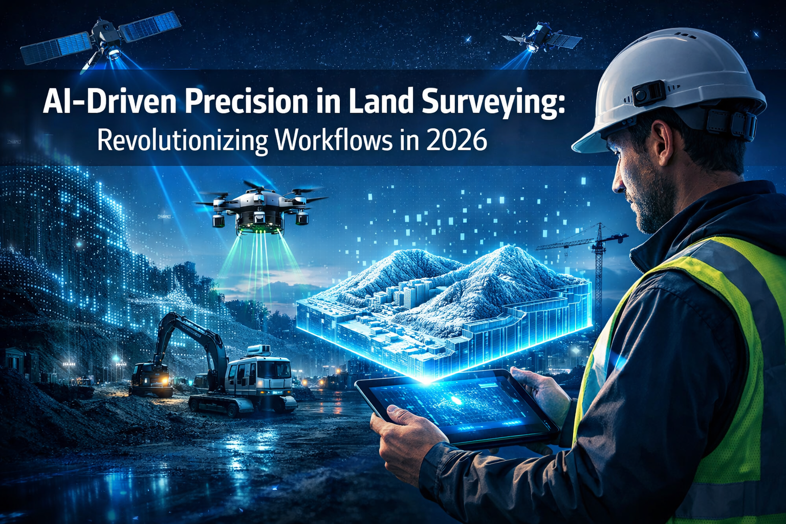
The land surveying industry stands at a transformative crossroads in 2026. What once required weeks of manual data processing, countless hours of quality checks, and extensive field revisits can now be accomplished in days—or even hours. AI-Driven Precision in Land Surveying: Revolutionizing Workflows in 2026 represents more than just technological advancement; it marks a fundamental shift in how surveying professionals approach their craft. Leading firms like Haller & Blanchard have already integrated AI-assisted quality checks into their review pipelines, with systems alerting surveyors to inconsistencies before projects reach the drafting stage.[1] This revolution isn't replacing surveyors—it's empowering them to focus on what they do best: applying expert judgment and solving complex spatial challenges.
Key Takeaways
-
🤖 Automated Intelligence: AI now instantly classifies terrain, identifies markers, flags anomalies, and generates preliminary surface models, shifting surveyor focus from data processing to expert analysis and decision-making.[1]
-
📊 Industry-Wide Adoption: A remarkable 94% of Architecture, Engineering, and Construction (AEC) professionals plan to increase AI usage in 2026, signaling unprecedented industry transformation despite historically slow technology adoption.[7]
-
🌍 Global Standards: The Royal Institution of Chartered Surveyors (RICS) has published the first mandatory global professional standard for responsible AI use in surveying, effective March 9, 2026, applying to members and regulated firms worldwide.[3]
-
🚁 Multi-Sensor Autonomy: Modern UAV systems carry synchronized sensor arrays combining LiDAR, photogrammetry, multispectral sensors, and thermal imaging, with autonomous flight planning and real-time adjustments for optimal data capture.[1]
-
☁️ Real-Time Collaboration: Cloud-based platforms have replaced static documents with interactive 3D digital twins that update continuously, enabling instant file sharing, browser-based visualization, and integrated team communication.[1]
Understanding AI-Driven Precision in Land Surveying: Revolutionizing Workflows in 2026

The Evolution from Manual to Intelligent Workflows
Traditional land surveying workflows required surveyors to manually sort through massive datasets, classify terrain features point by point, and spend countless hours identifying potential errors. The process was time-consuming, labor-intensive, and prone to human oversight—especially when dealing with millions of data points from modern scanning equipment.
AI has fundamentally changed this paradigm. Today's intelligent systems are directly embedded into core surveying workflows, where they instantly classify terrain, identify markers, flag anomalies, and generate preliminary surface models.[1] This integration doesn't eliminate the surveyor's role; rather, it elevates it by removing repetitive tasks and allowing professionals to focus on applying their expertise where it matters most.
The shift is dramatic. What once consumed 60-70% of a surveyor's time in data processing now happens automatically in the background. Surveyors can dedicate their energy to:
- Interpreting complex field conditions
- Making critical judgment calls on boundary disputes
- Ensuring legal compliance with local regulations
- Communicating findings to stakeholders
- Solving unique spatial challenges
How AI Transforms Core Surveying Tasks
Modern AI systems excel at several critical surveying functions:
| Task | Traditional Method | AI-Enhanced Method | Time Savings |
|---|---|---|---|
| Terrain Classification | Manual point-by-point sorting | Instant automated classification | 80-90% |
| Anomaly Detection | Visual inspection of data | Real-time flagging of inconsistencies | 75-85% |
| Quality Assurance | Post-processing manual checks | Integrated AI-assisted reviews | 70-80% |
| Surface Model Generation | Manual modeling and refinement | Automated preliminary models | 60-75% |
| Data Validation | Multiple review cycles | Continuous automated validation | 65-75% |
These improvements aren't theoretical. Firms implementing AI-assisted quality checks report catching errors earlier in the process, reducing costly field revisits, and delivering projects faster without compromising accuracy.[1]
Real-World Implementation: The Haller & Blanchard Example
Haller & Blanchard provides a compelling case study in practical AI integration. The firm has embedded AI-assisted quality checks directly into their review pipelines, creating a safety net that alerts surveyors to inconsistencies before projects reach the drafting stage.[1]
This approach offers several advantages:
✅ Early Error Detection: Problems are identified immediately rather than after extensive work has been completed
✅ Reduced Rework: Catching issues early eliminates costly backtracking and field revisits
✅ Improved Accuracy: Automated checks supplement human expertise, creating multiple validation layers
✅ Faster Turnaround: Projects move through the pipeline more efficiently with fewer delays
✅ Enhanced Client Satisfaction: Deliverables are more accurate and completed on schedule
The system doesn't replace professional judgment—it enhances it. Surveyors still make final decisions, but they're armed with AI-powered insights that highlight potential concerns they might otherwise miss in massive datasets.
For professionals seeking to understand modern surveyor services and their evolving capabilities, these AI integrations represent the new standard of excellence.
Advanced Technologies Powering AI-Driven Precision in Land Surveying
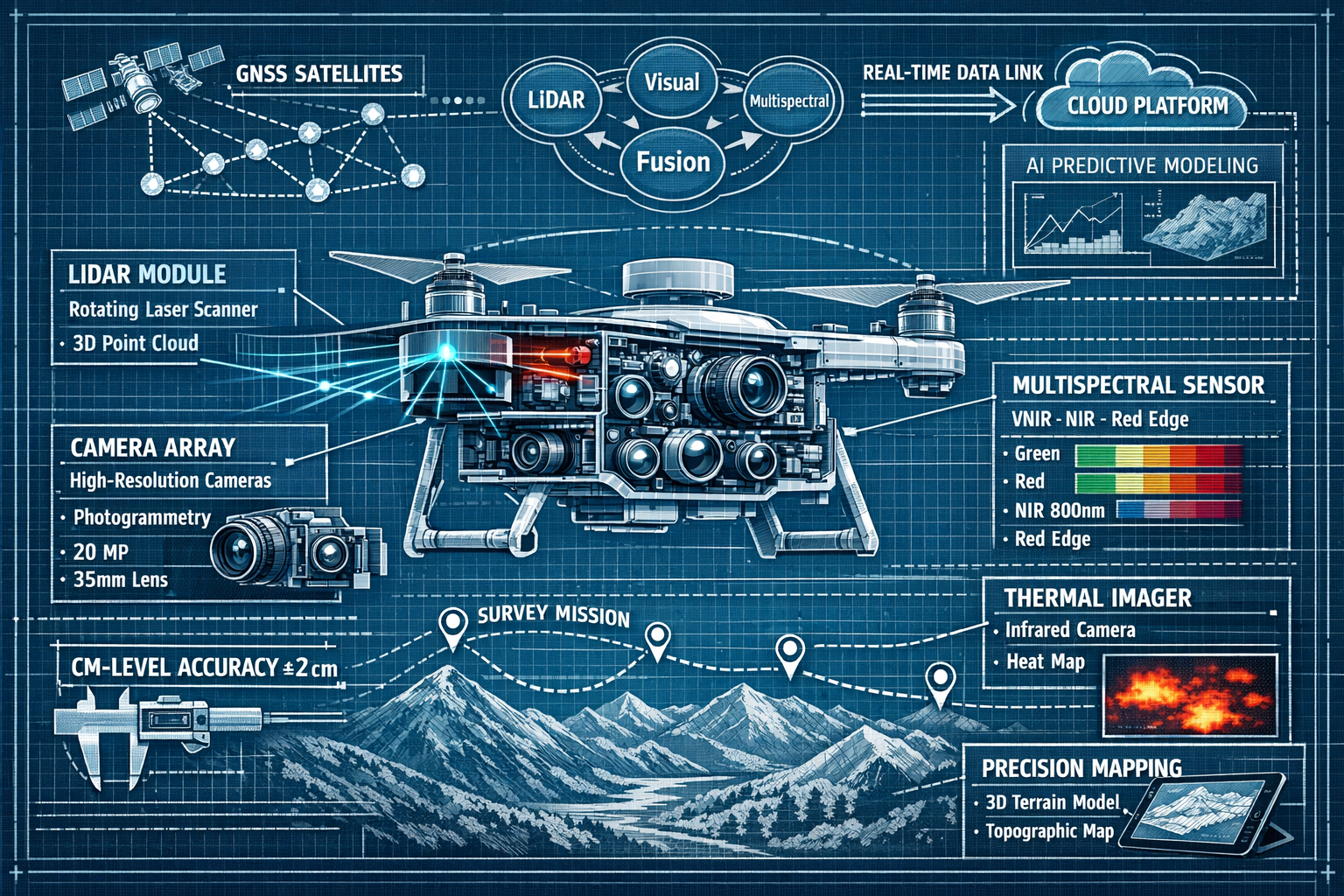
Multi-Sensor Autonomous Drone Systems
The drone revolution in surveying has entered its maturity phase in 2026. Modern UAV systems bear little resemblance to their predecessors from just five years ago. Today's platforms carry synchronized sensor arrays that combine multiple technologies working in concert:[1]
- LiDAR Scanners: Emit laser pulses to create precise 3D point clouds
- Photogrammetry Cameras: Capture high-resolution imagery for visual context
- Multispectral Sensors: Detect vegetation health, moisture levels, and material composition
- Thermal Imaging Units: Identify temperature variations and subsurface features
The real breakthrough isn't just carrying multiple sensors—it's the autonomous capabilities that allow drones to plan optimal flight paths using predictive modeling.[1] These intelligent systems automatically adjust altitude, angle, and sensor selection to achieve optimal readings based on terrain conditions, lighting, and project requirements.
This automation delivers several practical benefits:
🎯 Consistent Data Quality: Automated flight planning eliminates human variability in data collection
🎯 Adaptive Coverage: Drones adjust in real-time to ensure complete coverage without gaps
🎯 Optimal Sensor Usage: AI determines which sensors to activate for specific terrain features
🎯 Reduced Flight Time: Efficient path planning minimizes battery usage and project duration
🎯 Enhanced Safety: Autonomous systems navigate around obstacles and hazardous areas
For construction surveying applications, these multi-sensor drones can capture comprehensive site data in a single flight that previously required multiple visits with different equipment.
GNSS/GPS Enhancements and Centimeter-Level Accuracy
Global Navigation Satellite System (GNSS) technology has achieved remarkable precision improvements in 2026. Modern GPS systems now provide real-time data with centimeter-level accuracy, enabling more reliable surveyor results.[1]
This precision level represents a quantum leap from the meter-level accuracy of consumer GPS devices. For professional surveying, centimeter accuracy means:
- Precise boundary determinations in property disputes
- Accurate infrastructure placement for construction projects
- Reliable monitoring of ground movement and subsidence
- Exact positioning for utility mapping and underground services
However, this enhanced capability comes with new challenges. Survey professionals now play a critical role in ensuring collected data remains relevant, precise, and accurate against increased risks of GNSS jamming and spoofing, as well as fluctuating GNSS signals caused by solar cycle activity.[4]
AI systems help address these vulnerabilities by:
- Continuously monitoring signal quality and consistency
- Detecting anomalous readings that may indicate interference
- Cross-referencing multiple satellite constellations (GPS, GLONASS, Galileo, BeiDou)
- Alerting surveyors to potential accuracy issues in real-time
- Automatically switching to alternative positioning methods when signals degrade
LiDAR Mapping and 3D Laser Scanning Integration
LiDAR (Light Detection and Ranging) technology has become the backbone of modern precision surveying. These systems emit millions of laser pulses per second, creating incredibly detailed 3D point clouds that capture every surface feature with millimeter precision.
When combined with AI processing, LiDAR data becomes extraordinarily powerful:
Automated Feature Extraction: AI algorithms automatically identify and classify objects within point clouds—buildings, trees, power lines, roads, and terrain features—without manual intervention.
Noise Filtering: Intelligent systems remove atmospheric interference, bird flight paths, and other anomalies that would otherwise corrupt data.
Surface Modeling: AI generates accurate digital elevation models (DEMs) and digital terrain models (DTMs) by distinguishing ground points from above-ground features.
Change Detection: Comparing LiDAR scans over time reveals ground movement, erosion, construction progress, or unauthorized alterations with precision.
The integration of data analysis capabilities with LiDAR technology enables surveyors to extract actionable insights from billions of data points that would be impossible to process manually.
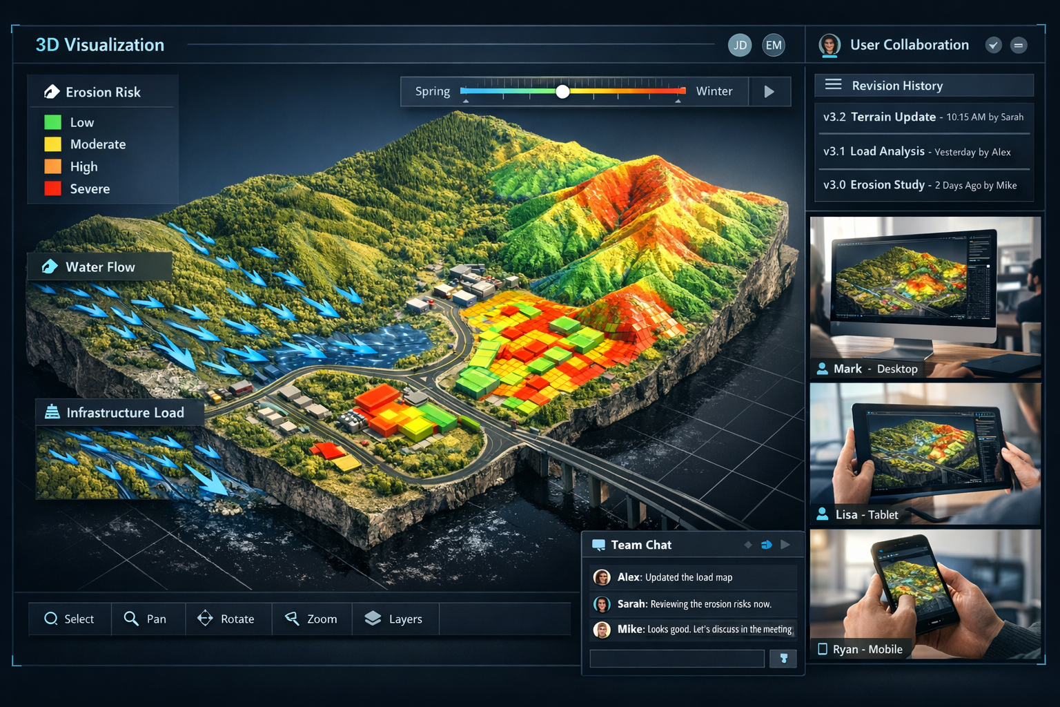
Real-Time 3D Digital Twins
Perhaps the most transformative development in 2026 is the emergence of high-fidelity, interactive 3D digital twins that update continuously as new data is collected.[1] These aren't static models—they're living representations of physical spaces that evolve with real-world changes.
Modern digital twins enable developers and engineers to visualize land behavior under various conditions:[1]
📍 Slope Erosion Projections: AI models predict how terrain will respond to rainfall, vegetation removal, or construction activities
📍 Water Flow Simulations: Hydrological modeling shows drainage patterns, flood risks, and optimal stormwater management
📍 Vegetation Pattern Changes: Seasonal and long-term plant growth predictions inform landscape planning
📍 Infrastructure Stress Testing: Virtual load testing identifies potential structural concerns before construction begins
These capabilities transform decision-making. Instead of relying on 2D plans and imagination, stakeholders can interact with realistic 3D environments, test scenarios, and visualize outcomes before committing resources.
For professionals conducting property condition assessments, digital twins provide unprecedented insight into how properties will perform under various conditions and stresses.
Cloud-Based Platforms and Collaborative Workflows in Modern Surveying
From Static Documents to Interactive Platforms
The traditional surveying deliverable—a static PDF report with 2D plans and cross-sections—has become obsolete in 2026. Today's surveying deliverables have shifted to interactive platforms that enable:[1]
- Instant File Sharing: Cloud-based access eliminates email attachments and version confusion
- 3D Visualization in Browsers: Stakeholders view and interact with models without specialized software
- Real-Time Revision Syncing: Changes propagate instantly to all team members
- Integrated Communication: Engineers, architects, and surveyors collaborate within the same platform
This transformation addresses a longstanding pain point in the construction industry: coordination across disciplines. When everyone works from the same real-time data source, miscommunication decreases, conflicts are identified earlier, and projects progress more smoothly.
Enhanced Collaboration Across Disciplines
Cloud platforms have broken down traditional silos between surveying, engineering, architecture, and construction teams. In 2026, these professionals work in synchronized environments where:
Surveyors upload field data that immediately populates the shared model
Engineers design infrastructure based on real-time topographic information
Architects ensure building designs align with actual site conditions
Contractors access current as-built conditions for construction planning
This integration is particularly valuable for construction projects where coordination between multiple disciplines determines project success.
Mobile Access and Field Connectivity
Modern surveyors aren't chained to office workstations. Cloud platforms provide full functionality on tablets and smartphones, enabling field teams to:
- Access project data and reference materials on-site
- Upload field observations and photos in real-time
- Receive immediate feedback from office-based reviewers
- Adjust survey plans based on unexpected field conditions
- Verify measurements against the digital model while still on location
This connectivity reduces the traditional lag between field work and office processing, accelerating project timelines and improving accuracy through immediate validation.
The RICS Global Standard for Responsible AI Use in Surveying
Landmark Professional Standards Taking Effect in 2026
In a historic development for the surveying profession, the Royal Institution of Chartered Surveyors (RICS) has published the first global professional standard for responsible AI use in surveying, set to take effect on March 9, 2026.[3] This mandatory standard applies to RICS members and regulated firms worldwide and addresses AI integration across valuation, construction, infrastructure, and land services.[3]
The standard represents recognition that AI has become integral to professional surveying practice and requires governance to ensure ethical, accurate, and responsible implementation.
Key Requirements of the RICS AI Standard
While the full standard encompasses numerous provisions, several key requirements stand out:
Transparency: Surveyors must disclose when AI systems contribute to professional deliverables and explain how these systems influenced conclusions.
Validation: AI-generated outputs require professional review and validation before being presented to clients or used for decision-making.
Competence: Practitioners must understand the AI tools they employ, including their limitations, potential biases, and appropriate use cases.
Data Quality: Input data must meet professional standards, as AI systems can only be as accurate as the information they process.
Accountability: Professional responsibility remains with the surveyor, not the AI system, for all deliverables and recommendations.
These requirements ensure that AI enhances rather than undermines professional standards. For chartered surveyors practicing in 2026, compliance with these standards is mandatory and represents best practices for the profession globally.
Implications for Surveying Firms and Professionals
The RICS standard creates both obligations and opportunities for surveying professionals:
Obligations:
- Implement quality assurance processes for AI-generated outputs
- Maintain documentation of AI system usage and validation
- Provide ongoing training for staff on responsible AI use
- Establish protocols for identifying and addressing AI limitations
Opportunities:
- Differentiate services through certified responsible AI implementation
- Build client confidence through transparent AI governance
- Reduce liability risks through structured validation processes
- Position firms as industry leaders in technological innovation
Firms that embrace these standards proactively will likely gain competitive advantages as clients increasingly demand both technological sophistication and professional accountability.
Industry Adoption Rates and Future Outlook for AI in Surveying
Unprecedented Adoption Rates in the AEC Sector
The Architecture, Engineering, and Construction (AEC) sector has historically been slow to adopt new technologies, often lagging years behind other industries in digital transformation. This makes the 2026 adoption statistics particularly remarkable.
According to a recent AEC sector survey, 94% of respondents plan to increase AI usage in 2026.[7] This represents an unprecedented surge in technology adoption for an industry known for conservative practices and traditional workflows.
Several factors drive this dramatic shift:
💡 Proven ROI: Early adopters have demonstrated clear returns on investment through reduced project timelines and improved accuracy
💡 Competitive Pressure: Firms without AI capabilities struggle to compete on speed and precision
💡 Client Expectations: Clients increasingly expect AI-enhanced deliverables as standard practice
💡 Labor Shortages: AI helps firms accomplish more with limited personnel resources
💡 Regulatory Support: Standards like the RICS framework provide clear implementation guidance
For building surveyors and other professionals, this adoption wave represents both a challenge and an opportunity to evolve their practice.
AI Applications in Infrastructure Assessment
One particularly impactful application of AI in surveying involves infrastructure condition assessment. Current data shows that 39% of USA roads are in poor condition,[4] highlighting the urgent need for efficient assessment capabilities.
AI tools enable faster and more automated evaluation of infrastructure elements:[4]
- Road Condition Analysis: Automated detection and classification of cracks, potholes, and surface deterioration
- Guard Rail Assessment: Identification of damaged or missing safety barriers
- Traffic Sign Evaluation: Recognition of faded, damaged, or obscured signage
- Bridge Inspection: Detection of structural defects, corrosion, and material degradation
- Utility Infrastructure: Mapping and condition assessment of underground services
Traditional infrastructure assessment required manual inspection of every element—a time-consuming process that often resulted in incomplete coverage. AI-powered systems can process mobile mapping data to assess hundreds of miles of infrastructure in the time previously required for a few miles.
This capability is particularly valuable for topographic mapping projects that include infrastructure inventories and condition assessments.
The Professional Surveyor's Evolving Role
A critical question emerges as AI capabilities expand: Will AI replace surveying professionals?
The answer, supported by industry consensus, is clear: AI will not fully replace surveying professionals. Instead, it significantly enhances the profession by automating data processing, improving accuracy, and reducing repetitive tasks while surveyors retain responsibility for decision-making, legal compliance interpretation, and managing complex field conditions.[2]
The surveyor's role is evolving rather than disappearing:
Traditional Focus:
- Manual data collection and processing
- Point-by-point terrain classification
- Repetitive quality checks
- Document preparation
Evolved Focus in 2026:
- Expert interpretation of AI-processed data
- Complex problem-solving for unusual conditions
- Legal and regulatory compliance guidance
- Client consultation and strategic planning
- Professional judgment on boundary disputes
- Ethical oversight of AI system outputs
This evolution mirrors transformations in other professions where technology augments rather than replaces human expertise. Just as accountants now focus on strategic tax planning rather than manual bookkeeping, surveyors increasingly apply their expertise to higher-value activities.
For those seeking property surveyors in 2026, the combination of AI efficiency and professional expertise delivers superior outcomes compared to either alone.
Challenges and Considerations for AI Implementation in Surveying
Data Quality and Input Validation
AI systems operate on a fundamental principle: garbage in, garbage out. No matter how sophisticated the algorithms, AI can only be as accurate as the data it processes. This creates critical responsibilities for surveying professionals:
Pre-Processing Validation: Field data must be verified for completeness and accuracy before AI processing begins.
Sensor Calibration: Equipment must be properly calibrated and maintained to ensure measurement precision.
Environmental Factors: Conditions like weather, vegetation, and atmospheric interference must be documented and accounted for.
Reference Point Verification: Control points and benchmarks require independent validation.
Survey professionals play an essential role in ensuring collected data meets quality standards, particularly given increased risks from GNSS signal vulnerabilities.[4]
Managing AI Limitations and Biases
While AI excels at pattern recognition and data processing, it has inherent limitations:
Context Blindness: AI may misclassify features in unusual contexts (e.g., identifying a decorative pond as a natural water body)
Training Data Bias: Systems trained primarily on urban environments may perform poorly in rural settings
Edge Cases: Unusual conditions not represented in training data can produce incorrect results
Overconfidence: AI systems don't inherently recognize when they're operating outside their competence
Responsible implementation requires surveyors to:
- Understand the training data and limitations of their AI tools
- Implement validation protocols for AI-generated classifications
- Maintain professional skepticism about automated outputs
- Override AI decisions when field conditions warrant
Cost and Training Considerations
Implementing AI-enhanced surveying workflows requires investment:
Technology Costs:
- Advanced sensor systems and drones
- Cloud platform subscriptions
- AI software licenses
- Computing infrastructure for data processing
Training Investments:
- Staff education on AI tool usage
- Understanding AI limitations and validation requirements
- Workflow redesign and optimization
- Ongoing professional development
Smaller firms may face challenges accessing these resources, potentially creating competitive disparities. However, cloud-based platforms and subscription models are making advanced capabilities increasingly accessible to firms of all sizes.
Legal and Liability Considerations
The integration of AI into professional surveying practice raises important legal questions:
Professional Responsibility: Who bears liability when AI-generated outputs prove inaccurate—the surveyor, the software vendor, or both?
Standard of Care: Do AI-enhanced capabilities raise the professional standard of care, making AI adoption effectively mandatory?
Disclosure Requirements: Must surveyors inform clients about AI usage in deliverables?
Data Security: How should firms protect sensitive survey data processed through cloud platforms?
The RICS global standard provides some guidance,[3] but legal frameworks continue to evolve. Surveying professionals must stay informed about regulatory developments and maintain appropriate professional insurance coverage.
Practical Applications Across Surveying Disciplines
Boundary and Property Surveying
AI-driven precision has transformed boundary determination and property surveying:
Historical Deed Research: AI can analyze historical documents, identifying relevant boundary descriptions and conflicting claims more efficiently than manual research.
Boundary Line Determination: Automated processing of GPS data with centimeter accuracy provides precise boundary locations.
Encroachment Detection: AI comparison of current conditions against property boundaries instantly identifies potential encroachments.
Evidence Documentation: Automated photo organization and annotation streamlines evidence collection for boundary disputes.
For property owners concerned about UK property boundaries, these AI enhancements provide greater confidence in boundary determinations.
Construction and Site Surveying
Construction projects benefit enormously from AI-enhanced surveying:
Site Preparation: Digital twins enable optimal grading plans that minimize earthwork costs while ensuring proper drainage.
Progress Monitoring: Regular drone surveys with AI-powered change detection track construction progress against plans.
Quality Control: Automated comparison of as-built conditions against design specifications identifies deviations early.
Volume Calculations: AI-processed point clouds deliver accurate cut-and-fill calculations for earthwork projects.
These capabilities are particularly valuable for construction surveying projects where accuracy and timeliness directly impact project costs and schedules.
Infrastructure and Transportation Surveying
Transportation agencies and infrastructure owners leverage AI for:
Corridor Mapping: Automated feature extraction from mobile mapping data creates comprehensive infrastructure inventories.
Condition Assessment: AI-powered image analysis identifies pavement distress, structural defects, and maintenance needs.
Asset Management: Digital twins track infrastructure condition over time, supporting data-driven maintenance decisions.
Design Optimization: AI analysis of existing conditions informs efficient alignment and design decisions.
Environmental and Resource Surveying
Environmental applications of AI-enhanced surveying include:
Vegetation Analysis: Multispectral imaging with AI classification maps plant species, health, and coverage.
Erosion Monitoring: Change detection identifies erosion patterns and rates over time.
Wetland Delineation: AI processing of elevation and vegetation data assists in wetland boundary determination.
Mining and Quarrying: Volumetric analysis tracks material extraction and site reclamation progress.
Best Practices for Implementing AI in Surveying Workflows
Starting with Clear Objectives
Successful AI implementation begins with well-defined goals:
✓ Identify Pain Points: Which current processes are most time-consuming or error-prone?
✓ Define Success Metrics: How will you measure improvement (time savings, error reduction, client satisfaction)?
✓ Prioritize Applications: Start with high-impact, lower-complexity applications before tackling more challenging implementations.
✓ Set Realistic Expectations: Understand that AI enhances rather than replaces professional judgment.
Building a Phased Implementation Plan
Rather than attempting comprehensive transformation overnight, successful firms adopt phased approaches:
Phase 1: Pilot Projects
- Select limited-scope projects for initial AI integration
- Document results, challenges, and lessons learned
- Refine workflows based on real-world experience
Phase 2: Expanded Deployment
- Apply AI to broader project categories
- Train additional staff on validated workflows
- Develop standardized protocols for AI usage
Phase 3: Full Integration
- Embed AI throughout standard operating procedures
- Optimize workflows based on accumulated experience
- Pursue advanced applications and capabilities
Investing in Staff Training and Development
Technology is only as effective as the people using it:
Technical Training: Ensure staff understand how to operate AI-enhanced tools effectively.
Conceptual Understanding: Help team members grasp AI capabilities and limitations.
Professional Judgment: Emphasize that AI supports rather than replaces professional expertise.
Continuous Learning: Technology evolves rapidly; ongoing education is essential.
Firms that invest in their people alongside technology investments achieve superior results.
Establishing Quality Assurance Protocols
Responsible AI implementation requires robust validation:
Automated Checks: Implement AI-assisted quality reviews like those used by Haller & Blanchard.[1]
Manual Validation: Establish protocols for professional review of AI-generated outputs.
Documentation Standards: Maintain records of AI usage and validation for each project.
Feedback Loops: Use identified errors to improve AI training and validation processes.
These protocols ensure compliance with professional standards while maximizing AI benefits.
Maintaining Professional Standards and Ethics
As AI capabilities expand, maintaining professional integrity becomes increasingly important:
- Always disclose AI usage to clients when material to deliverables
- Never allow AI to make final professional judgments without human oversight
- Maintain competence in both traditional and AI-enhanced methodologies
- Prioritize accuracy and client service over speed and efficiency
- Comply with RICS standards and other applicable professional requirements[3]
For those seeking RICS surveys, these professional standards provide assurance that AI enhances rather than compromises quality.
Future Developments on the Horizon
Emerging Technologies Complementing AI
Several technologies will further enhance AI-driven surveying in coming years:
Quantum Computing: Future quantum systems may enable real-time processing of massive datasets currently requiring hours of computation.
5G and 6G Connectivity: Enhanced bandwidth will support real-time streaming of high-resolution sensor data from field to office.
Advanced Sensor Fusion: Next-generation systems will integrate even more sensor types, creating comprehensive multi-dimensional datasets.
Edge Computing: Processing data directly on survey equipment will reduce latency and enable immediate field validation.
Augmented Reality: AR headsets will overlay digital models onto physical environments, enhancing field verification and client communication.
Integration with Building Information Modeling (BIM)
The convergence of AI-enhanced surveying with BIM workflows will create seamless project lifecycles:
- Survey data automatically populates BIM models with as-built conditions
- Design changes immediately highlight survey conflicts
- Construction progress tracked against both design and survey data
- Facility management informed by comprehensive as-built documentation
This integration will be particularly valuable for commercial property inspections and complex development projects.
Predictive Analytics and Machine Learning Advances
Future AI systems will move beyond classification and detection to prediction:
Ground Movement Prediction: AI analysis of historical data to forecast subsidence, settlement, or landslide risks.
Infrastructure Deterioration Modeling: Predictive maintenance based on condition trends and environmental factors.
Project Risk Assessment: AI evaluation of site conditions to identify potential construction challenges.
Optimal Survey Planning: Machine learning systems that recommend survey methodologies based on project requirements and site conditions.
Regulatory Evolution and Standardization
As AI becomes ubiquitous in surveying, expect:
- Additional professional standards beyond the RICS framework[3]
- Government regulations addressing AI in critical infrastructure assessment
- Industry-wide data standards facilitating AI interoperability
- Certification programs for AI-enhanced surveying capabilities
- Enhanced liability frameworks addressing AI-related professional risks
Conclusion: Embracing the AI-Enhanced Future of Land Surveying
AI-Driven Precision in Land Surveying: Revolutionizing Workflows in 2026 represents far more than technological novelty—it marks a fundamental evolution in how surveying professionals serve their clients and communities. The transformation is comprehensive, touching every aspect of surveying practice from field data collection through final deliverable preparation.
The statistics tell a compelling story: 94% of AEC professionals planning to increase AI usage in 2026[7] signals industry-wide recognition that AI integration is no longer optional but essential for competitive practice. Firms like Haller & Blanchard demonstrate that practical implementation delivers tangible benefits through AI-assisted quality checks and streamlined workflows.[1]
Yet amid this technological revolution, the human element remains paramount. The RICS global standard for responsible AI use[3] acknowledges that professional judgment, ethical oversight, and expert interpretation cannot be automated. Surveyors who successfully navigate this transformation will combine AI efficiency with professional expertise, delivering superior outcomes impossible with either alone.
Actionable Next Steps for Surveying Professionals
For surveyors seeking to embrace AI-enhanced workflows in 2026:
1. Assess Current Capabilities
- Evaluate existing technology and identify gaps
- Benchmark workflows against AI-enhanced alternatives
- Identify high-impact opportunities for AI integration
2. Develop an Implementation Roadmap
- Prioritize applications based on ROI and complexity
- Establish realistic timelines for phased deployment
- Budget for technology, training, and process refinement
3. Invest in Education and Training
- Ensure staff understand AI capabilities and limitations
- Provide hands-on training with AI-enhanced tools
- Emphasize professional standards and validation requirements
4. Establish Quality Assurance Protocols
- Implement validation processes for AI-generated outputs
- Document AI usage and professional review for each project
- Create feedback loops for continuous improvement
5. Stay Informed on Regulatory Developments
- Monitor RICS standards and other professional requirements[3]
- Participate in professional organizations and industry forums
- Maintain awareness of emerging best practices
6. Communicate Value to Clients
- Explain how AI enhances accuracy and efficiency
- Demonstrate transparency in AI usage and validation
- Differentiate services through responsible AI implementation
For property owners and developers seeking surveying services in 2026, these AI enhancements translate to faster project timelines, greater accuracy, and more comprehensive deliverables. Whether commissioning property inspections or complex infrastructure surveys, clients benefit from the combination of cutting-edge technology and professional expertise.
The future of land surveying is not about choosing between human expertise and artificial intelligence—it's about harnessing both to achieve results previously impossible with either alone. As autonomous drones collect comprehensive multi-sensor data, AI systems process billions of data points instantly, and cloud platforms enable real-time collaboration, surveying professionals apply their irreplaceable judgment, experience, and ethical oversight to ensure accuracy, compliance, and client service.
AI-Driven Precision in Land Surveying: Revolutionizing Workflows in 2026 isn't a distant future—it's the present reality for leading firms and the immediate imperative for all surveying professionals committed to excellence in their craft.
References
[1] Future Land Surveying 2026 – https://haller-blanchard.com/future-land-surveying-2026/
[2] The Future Of Land Surveying Technology And Upcoming Trends In 2026 – https://metricop.com/blogs/land-surveying/the-future-of-land-surveying-technology-and-upcoming-trends-in-2026
[3] Rics Launches Landmark Global Standard On Responsible Use Of Ai In Surveying – https://www.rics.org/news-insights/rics-launches-landmark-global-standard-on-responsible-use-of-ai-in-surveying
[4] How Ai Is Changing The Role Of The Surveyor In Aec – https://www.gim-international.com/content/article/how-ai-is-changing-the-role-of-the-surveyor-in-aec
[7] Architecture Engineering Construction Sector Slow To Adapt Ai Survey Shows – https://www.asce.org/publications-and-news/civil-engineering-source/article/2025/12/18/architecture-engineering-construction-sector-slow-to-adapt-ai-survey-shows