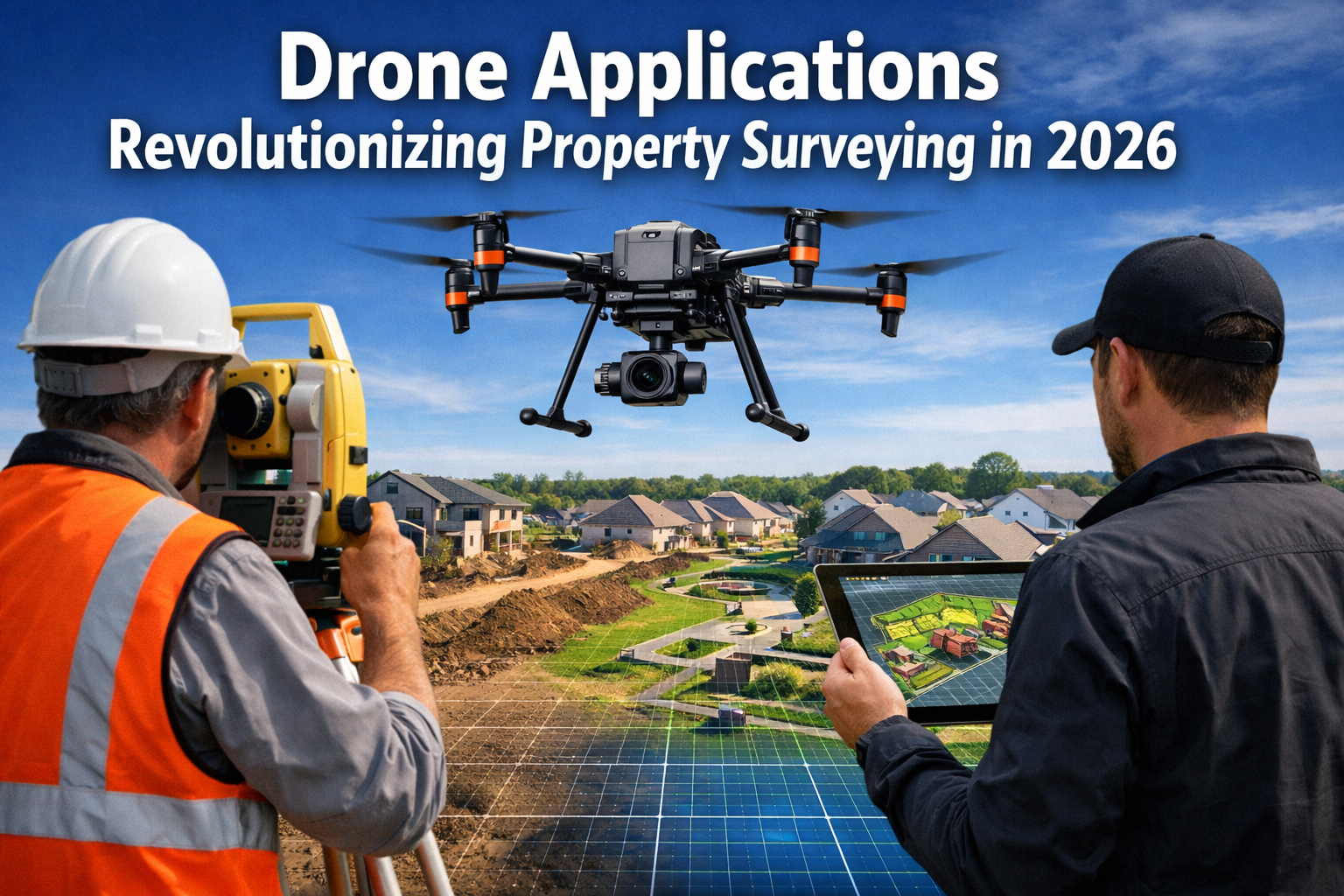
The property surveying industry stands at a transformative crossroads in 2026. Where traditional surveying methods once required teams of professionals spending days or weeks measuring land with ground-based equipment, affordable unmanned aerial vehicles (UAVs) equipped with high-resolution cameras and LiDAR sensors now complete the same tasks in mere hours. This technological revolution represents more than just efficiency gains—it fundamentally reshapes how property professionals approach topographic surveys, development planning, and site analysis. The Drone Applications Revolutionizing Property Surveying in 2026: Techniques, Benefits, and Best Practices have become essential knowledge for anyone involved in property development, construction, or land management.
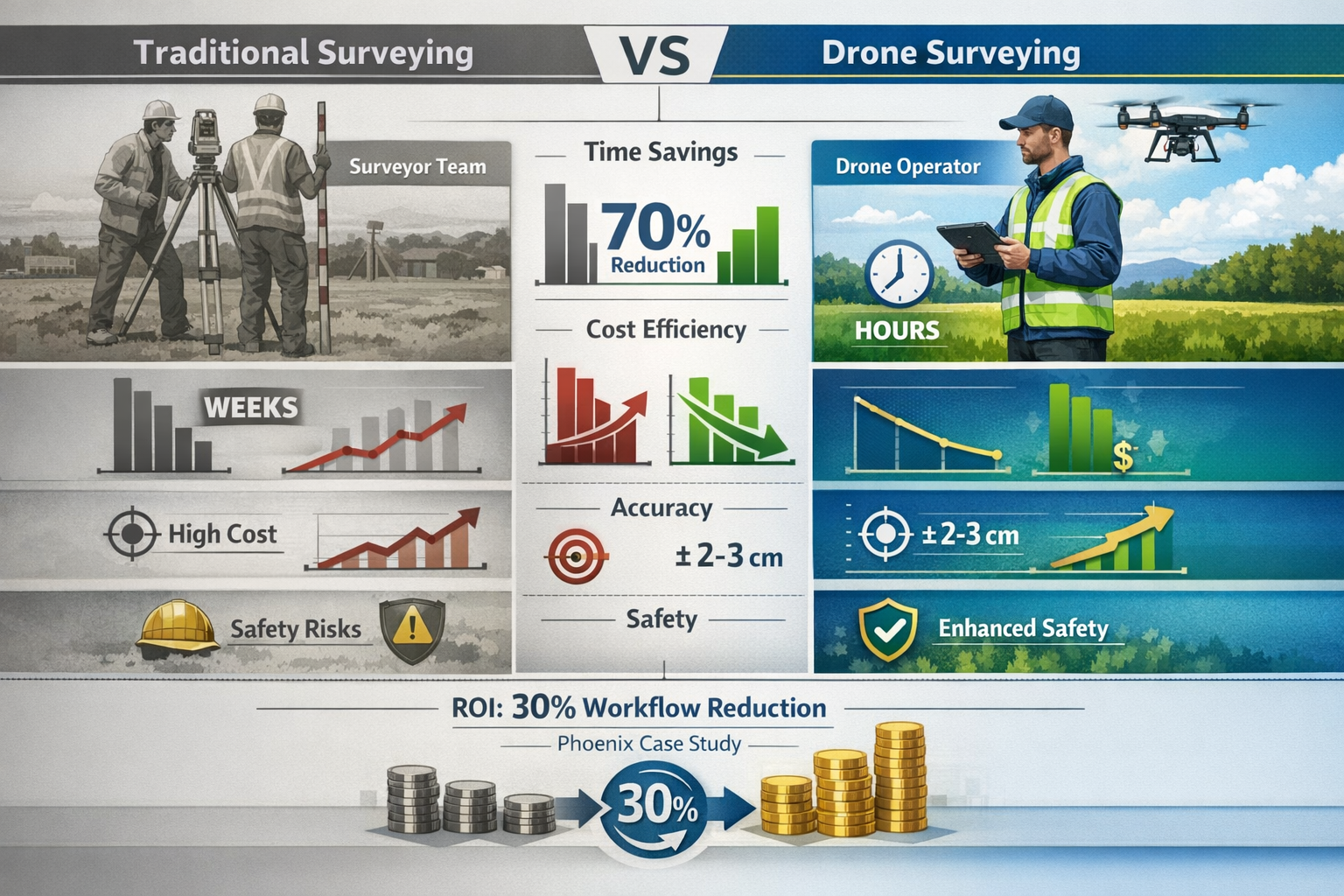
The numbers tell a compelling story. The drone mapping market is expected to exceed $6.5 billion by 2026[4], while over 70% of US construction projects adopted drone surveys in 2025[4] for mapping and monitoring purposes. This widespread adoption reflects not just technological capability but genuine business value—projects report 30% reduction in pre-construction workflows[4] and accuracy levels reaching an impressive 1cm precision[2].
Key Takeaways
✈️ Unprecedented Speed and Efficiency: Property surveys that traditionally required days or weeks can now be completed in hours using drone technology, dramatically accelerating project timelines and reducing operational costs[1].
📊 Centimeter-Level Precision: Enterprise-grade surveying drones achieve accuracy down to 1cm, delivering data quality that matches or exceeds traditional ground-based surveying methods[2].
💰 Significant Cost Reduction: Drone surveying requires fewer personnel and equipment while delivering superior data quality, making large-scale topographic surveys financially accessible for more property development projects[1].
🤖 AI-Powered Intelligence: Modern drone applications integrate artificial intelligence, advanced LiDAR, and seamless BIM/GIS platform connectivity to transform raw aerial data into actionable property insights[4].
📈 Industry-Standard Adoption: With 70% of construction projects now utilizing drone surveys, this technology has moved from experimental to essential for competitive property development operations[4].
Understanding Modern Drone Surveying Technology
The Evolution of UAV Surveying Capabilities
The landscape of drone technology has transformed dramatically over recent years. Modern surveying drones bear little resemblance to the consumer quadcopters that first captured public imagination. Today's enterprise-grade mapping platforms represent sophisticated aerial data collection systems purpose-built for professional surveying applications.
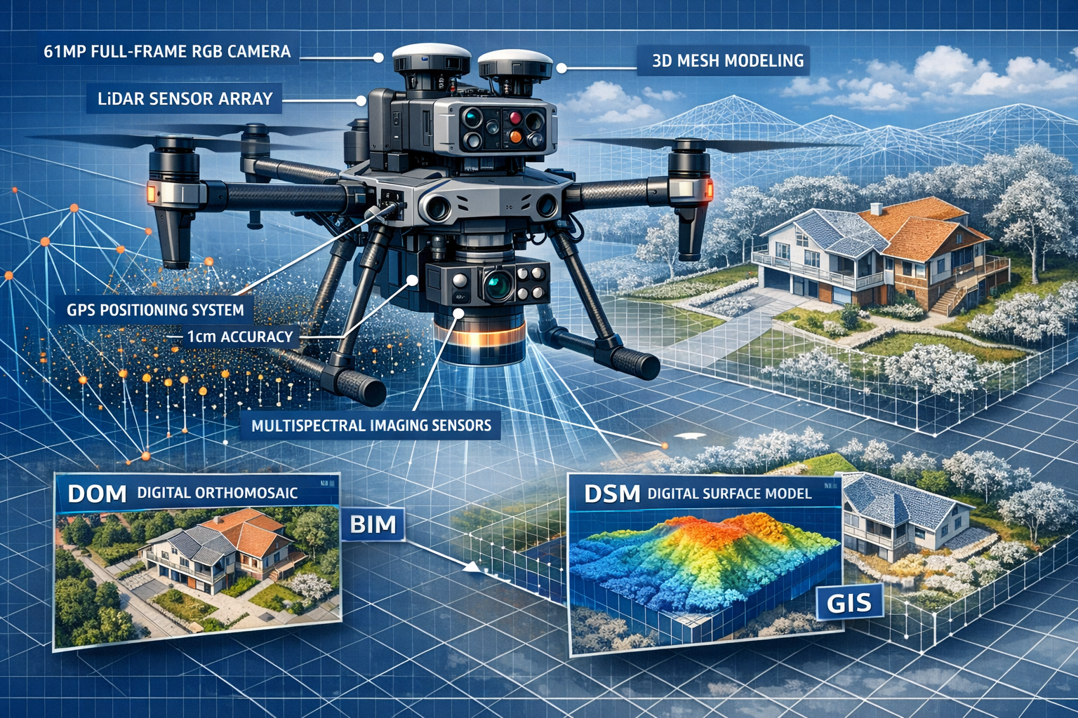
Contemporary surveying drones integrate multiple sensor systems working in concert. High-resolution cameras—including models with 61MP full-frame RGB sensors[2]—capture detailed imagery that forms the foundation of photogrammetric analysis. These cameras work alongside LiDAR (Light Detection and Ranging) systems that emit laser pulses to measure distances with extraordinary precision, creating detailed three-dimensional point clouds of terrain and structures.
Multispectral imaging sensors add another dimension to property analysis[4]. While invisible to the human eye, these sensors detect light across multiple wavelengths, revealing information about vegetation health, soil composition, moisture levels, and surface materials—data particularly valuable for agricultural properties, solar farm development, and environmental assessments.
How Drone Photogrammetry Creates Accurate Property Models
The process of transforming aerial photographs into precise survey data relies on photogrammetry—the science of making measurements from photographs. When a drone captures hundreds or thousands of overlapping images during a systematic flight pattern, specialized software analyzes these images to identify common features and calculate their three-dimensional positions.
This computational process generates several industry-standard outputs[3]:
- DOM (Digital Orthomosaic): A geometrically corrected aerial photograph where the scale is uniform across the entire image, allowing accurate distance and area measurements
- DSM (Digital Surface Model): A representation showing the elevation of all surfaces including buildings, trees, and other features
- 3D Reality Models: Detailed three-dimensional reconstructions of properties and terrain that can be explored from any angle
The accuracy of these outputs depends on several factors: image overlap (typically 70-80% front and side overlap), ground control points for georeferencing, camera quality, and flight altitude. Modern systems can achieve horizontal accuracy of 1-2cm and vertical accuracy of 2-3cm[2] under optimal conditions—precision that meets or exceeds requirements for most property surveying applications.
LiDAR Technology for Complex Terrain and Vegetation
While photogrammetry excels in many scenarios, LiDAR technology offers distinct advantages for challenging environments. Traditional aerial photography struggles to penetrate vegetation canopy, making it difficult to determine actual ground elevation beneath trees and dense foliage. LiDAR pulses, however, can pass through gaps in vegetation, with some laser returns bouncing off leaves while others reach the ground below.
This capability proves invaluable for topographic surveys of wooded properties, where understanding both the surface vegetation and underlying terrain matters for development planning. LiDAR systems can classify returns into categories—ground, vegetation, buildings, water—enabling surveyors to generate accurate bare-earth models even for heavily forested sites.
The integration of LiDAR with traditional RGB imaging creates comprehensive datasets that combine visual detail with precise elevation data. This multimodal approach has become standard practice for complex property surveys where both appearance and accurate measurements matter. Understanding what surveyors do helps property owners appreciate how these advanced tools enhance traditional surveying expertise.
Core Techniques in Drone Applications Revolutionizing Property Surveying in 2026
Systematic Flight Planning and Mission Design
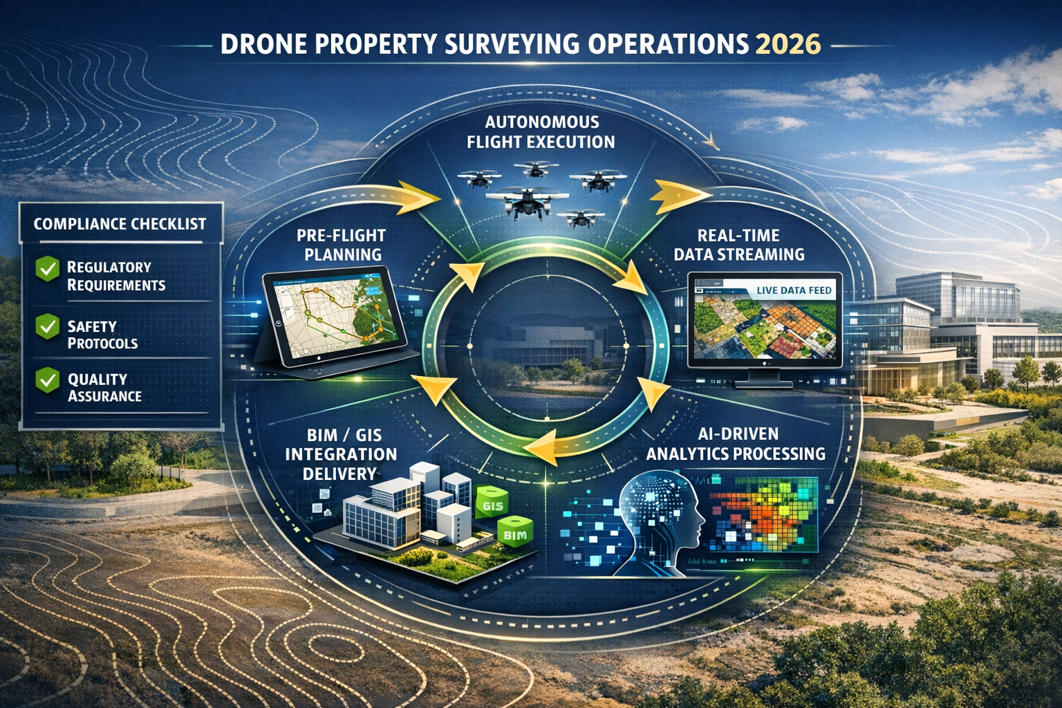
Successful drone surveying begins long before the UAV takes flight. Mission planning determines the quality, completeness, and efficiency of data collection. Professional surveyors use specialized software to design flight paths that ensure complete coverage of the survey area with appropriate image overlap.
Key planning considerations include:
Flight Altitude: Higher flights cover more area per image but sacrifice ground resolution. Lower flights provide finer detail but require more images and longer flight times. Typical surveying missions fly between 50-120 meters altitude, balancing efficiency with the required ground sample distance (GSD).
Image Overlap: Professional surveys typically specify 70-80% forward overlap and 60-70% side overlap. This redundancy ensures every point on the ground appears in multiple images from different angles—essential for accurate photogrammetric reconstruction.
Ground Control Points (GCPs): These precisely surveyed markers placed throughout the survey area provide known reference coordinates that dramatically improve absolute accuracy. While RTK (Real-Time Kinematic) and PPK (Post-Processed Kinematic) GPS systems reduce GCP requirements, they remain valuable for high-accuracy applications.
Weather and Lighting: Optimal surveying occurs during overcast conditions that provide even lighting without harsh shadows. Wind speed, precipitation, and visibility all affect flight safety and data quality.
Modern flight planning software automates much of this process, calculating optimal flight paths, estimating battery requirements, and identifying potential obstacles. This automation enables consistent, repeatable surveys—particularly valuable for monitoring surveys that track changes over time.
Real-Time Data Processing and Visualization
One of the most significant advances in drone surveying technology is the shift toward real-time processing capabilities. Traditionally, surveyors collected data in the field, then spent hours or days processing it back at the office before results became available. This delay created challenges for time-sensitive projects and prevented immediate verification of data quality.
Current systems can generate real-time 2D orthomosaics during data collection[3], enabling teams to visualize land cover and identify changes without waiting for post-processing. This immediate feedback offers several advantages:
Field Verification: Surveyors can confirm complete coverage and adequate data quality while still on-site, eliminating costly return visits to fill gaps or recapture poor-quality imagery.
Stakeholder Communication: Project managers and clients can view preliminary results within hours rather than days, accelerating decision-making and approvals.
Adaptive Surveying: Real-time visualization allows surveyors to identify areas requiring additional detail or alternative sensor data, adjusting flight plans on the fly.
Autonomous drone fleets capable of streaming site data in real-time to project dashboards[4] represent the cutting edge of this technology. These systems enable continuous monitoring of active construction sites, automatically detecting changes and alerting project teams to deviations from plans or potential issues.
Integration with BIM and GIS Platforms
The true value of drone survey data emerges when it integrates seamlessly with the broader digital ecosystem of property development and management. Building Information Modeling (BIM) and Geographic Information Systems (GIS) platforms serve as central repositories for project information, and drone-generated models now flow directly into these systems[4].
This integration enables powerful workflows:
As-Built Verification: Comparing drone-captured reality models against design BIM models reveals construction deviations, helping teams identify issues before they become costly problems.
Cut-Fill Analysis: Accurate elevation models enable precise calculation of earthwork volumes, optimizing grading plans and reducing material costs.
Site Planning: Overlaying proposed development plans on accurate existing conditions models helps architects and engineers design projects that work with rather than against site topography.
Asset Management: Regular drone surveys create time-stamped records of property conditions, supporting maintenance planning and property condition assessments.
The seamless flow of data from drone to desktop to decision represents a fundamental shift from surveying as an isolated task to surveying as an integrated component of comprehensive property intelligence systems. This integration proves particularly valuable when addressing common myths about property surveys, demonstrating how modern technology delivers both speed and accuracy.
Advanced Applications: Multispectral and Thermal Imaging
Beyond visible-light photography and LiDAR, specialized sensors expand drone surveying capabilities into new domains. Multispectral imaging captures data across multiple specific wavelengths, revealing information invisible to standard cameras[4].
For property surveying, multispectral applications include:
Vegetation Analysis: Different plant species and health conditions reflect light differently across the spectrum. Multispectral data helps assess landscape conditions, identify diseased vegetation, and evaluate agricultural property productivity.
Moisture Detection: Certain wavelengths reveal moisture content in soil and building materials, supporting damp surveys and drainage analysis without invasive testing.
Solar Farm Optimization: Multispectral data helps identify optimal panel placement by analyzing sun exposure patterns and ground conditions across large sites.
Thermal imaging adds another valuable data layer, detecting temperature variations that indicate:
- Heat loss from buildings, identifying insulation deficiencies
- Underground utilities and infrastructure through temperature signatures
- Moisture intrusion in roofing and building envelopes
- Electrical system hotspots indicating potential failures
These advanced sensing capabilities transform drones from simple cameras in the sky to comprehensive property diagnostic platforms, collecting data that would be difficult or impossible to obtain through traditional ground-based methods.
Benefits of Drone Applications Revolutionizing Property Surveying in 2026
Dramatic Time Savings and Project Acceleration
Perhaps the most immediately apparent benefit of drone surveying is the extraordinary reduction in time requirements. Property surveys that traditionally required days or weeks can now be completed in hours[1], fundamentally changing project timelines and enabling faster decision-making.
Consider a typical scenario: surveying a 50-acre development site using traditional methods might require a team of 3-4 surveyors working for several days to establish control networks, collect topographic data, and process measurements. The same survey conducted with a drone might involve:
- 1-2 hours of flight planning and setup
- 30-60 minutes of actual flight time
- 2-4 hours of data processing
This represents a time reduction of 70-80% compared to traditional methods—time savings that cascade through the entire project schedule. Faster surveys mean quicker feasibility assessments, earlier design starts, and reduced holding costs for property developers.
The speed advantage proves particularly valuable for time-sensitive applications like monitoring construction progress, where regular surveys track earthwork, structural completion, and site conditions. Weekly or even daily drone surveys become economically feasible, providing project managers with current data to support proactive decision-making rather than reactive problem-solving.
Significant Cost Reduction and ROI
The economic case for drone surveying extends beyond time savings to fundamental cost advantages across multiple dimensions[1]:
Reduced Labor Requirements: Traditional surveying requires teams of professionals working in the field for extended periods. Drone operations typically need just one licensed pilot and one assistant, dramatically reducing labor costs.
Lower Equipment Costs: While professional surveying drones represent a significant investment (typically $15,000-$100,000 depending on capabilities), this compares favorably to the total cost of traditional surveying equipment—total stations, GPS receivers, levels, and vehicles—required for comprehensive ground-based surveys.
Minimized Site Disruption: Aerial surveys don't require access to every part of a property, eliminating costs associated with clearing access paths, securing permissions for entry to adjacent properties, or temporarily halting construction activities.
Decreased Safety Costs: Keeping surveyors out of hazardous areas reduces insurance costs, liability exposure, and potential accident-related expenses.
Real-world data supports these theoretical advantages. The Phoenix highway expansion project documented a 30% reduction in pre-construction workflows[4] using drone mapping and 3D modeling—savings that directly improved project ROI and competitive positioning.
For property buyers and developers, these cost reductions make comprehensive surveying economically accessible for projects where traditional surveying costs might have seemed prohibitive. This democratization of accurate property data supports better-informed decisions across the real estate market.
Enhanced Safety for Surveyors and Site Personnel
Traditional property surveying often requires professionals to work in challenging and potentially dangerous environments: steep slopes, unstable terrain, active construction zones, areas with structural concerns, or properties with hazardous materials. Drone surveying eliminates or dramatically reduces these safety risks[1] by keeping personnel out of harm's way.
Safety benefits include:
Hazardous Site Assessment: Drones can survey damaged structures, contaminated sites, or unstable slopes without exposing personnel to risk, providing critical data for remediation planning.
Traffic Zone Surveys: Roadway and infrastructure surveys can be conducted without placing surveyors in active traffic lanes, eliminating a significant source of workplace accidents.
Roof Inspections: Rather than climbing ladders and walking on potentially unstable roofing, inspectors can capture detailed roof conditions from the safety of the ground.
Confined Space Evaluation: Specialized indoor drones can inspect areas that would require confined space entry protocols and associated safety equipment.
This safety advantage carries both humanitarian and economic value. Preventing surveyor injuries protects individuals while avoiding the direct costs of accidents and the indirect costs of project delays, insurance claims, and regulatory complications.
Superior Data Quality and Completeness
While speed and cost matter, they mean little if data quality suffers. Remarkably, drone surveying not only matches but often exceeds the accuracy and completeness of traditional methods[2].
Comprehensive Coverage: Drones capture data across entire properties in a single continuous operation, eliminating gaps that might occur when ground-based surveyors miss areas due to access challenges or oversight. The systematic, automated nature of drone flight patterns ensures consistent, complete coverage.
Centimeter-Level Accuracy: Modern surveying drones achieve accuracy down to 1cm[2] when properly calibrated with ground control points and RTK/PPK GPS systems. This precision meets or exceeds requirements for most property development applications, including site grading, foundation layout, and infrastructure design.
Rich Visual Context: Beyond measurements, drone surveys provide high-resolution imagery that documents existing conditions comprehensively. This visual record proves invaluable for design teams, construction managers, and property owners, offering context that raw survey points cannot convey.
Temporal Consistency: Drone surveys can be repeated at regular intervals using identical flight parameters, creating perfectly comparable datasets that reveal changes over time with exceptional clarity—essential for structural monitoring and settlement analysis.
The combination of speed, cost-effectiveness, safety, and data quality creates a compelling value proposition that explains why drone surveying has achieved 70% adoption in US construction projects[4] in just a few years.
Improved Stakeholder Communication and Collaboration
Beyond technical advantages, drone surveying transforms how project teams communicate and collaborate. The visual, intuitive nature of drone-generated outputs—orthomosaics, 3D models, and reality meshes—makes complex spatial information accessible to stakeholders who might struggle to interpret traditional survey plans and cross-sections.
This accessibility improves collaboration in several ways:
Client Presentations: Property developers can show investors and lenders realistic 3D models of existing conditions and proposed developments, supporting more effective fundraising and approval processes.
Design Coordination: Architects, engineers, and landscape designers working from the same accurate 3D model reduce coordination conflicts and design errors.
Regulatory Approvals: Planning authorities increasingly accept drone-generated documentation for permit applications, and the visual clarity of these submissions can expedite approval processes.
Public Engagement: For projects requiring community input, 3D visualizations help non-technical stakeholders understand proposals and provide meaningful feedback.
When considering what to check before buying a leasehold property, having access to comprehensive drone survey data provides buyers with unprecedented visibility into property conditions and surrounding context.
Best Practices for Implementing Drone Surveying Programs
Regulatory Compliance and Licensing Requirements
Operating drones for commercial property surveying requires compliance with aviation regulations that vary by jurisdiction but share common elements. In the UK, the Civil Aviation Authority (CAA) regulates drone operations, while the Federal Aviation Administration (FAA) governs US airspace.
Key regulatory requirements typically include:
Operator Certification: Commercial drone pilots must obtain appropriate licenses—the CAA's A2 Certificate of Competency in the UK or FAA Part 107 Remote Pilot Certificate in the US. These certifications require passing knowledge tests covering airspace regulations, weather, flight operations, and emergency procedures.
Aircraft Registration: Drones used for commercial purposes must be registered with the appropriate aviation authority and display registration numbers.
Operational Limitations: Regulations typically restrict flights to daylight hours, below certain altitudes (400 feet in the US), within visual line of sight, and away from airports, crowds, and restricted airspace without special permissions.
Privacy and Data Protection: Drone operators must comply with privacy laws when capturing images of properties, particularly residential areas. GDPR in Europe and various state laws in the US impose requirements on data collection, storage, and use.
Insurance Requirements: Professional liability insurance specifically covering drone operations protects against potential claims arising from accidents, privacy violations, or professional errors.
Staying current with evolving regulations requires ongoing education and attention to regulatory updates. Many professional surveying organizations offer resources and training to help members maintain compliance while maximizing operational capabilities.
Selecting Appropriate Equipment for Your Applications
The drone market offers hundreds of models ranging from consumer toys to enterprise surveying platforms. Selecting equipment appropriate to your specific surveying needs requires balancing capability, cost, and operational requirements.
| Equipment Category | Typical Cost Range | Best Applications | Key Features |
|---|---|---|---|
| Consumer Drones | $500-$2,000 | Small property documentation, preliminary assessments | Basic cameras, limited flight time, manual controls |
| Prosumer Mapping Drones | $2,000-$15,000 | Residential surveys, small commercial projects | High-resolution cameras, automated flight, basic mapping software |
| Enterprise Survey Platforms | $15,000-$50,000 | Professional topographic surveys, large developments | RTK/PPK GPS, interchangeable sensors, advanced processing |
| LiDAR-Equipped Systems | $50,000-$150,000+ | Complex terrain, vegetation penetration, high-accuracy applications | Integrated LiDAR, multispectral options, centimeter accuracy |
Beyond the aircraft itself, consider the complete system:
Sensors: Does your work require standard RGB cameras, multispectral imaging, thermal sensors, or LiDAR? Some platforms offer interchangeable payloads for flexibility.
Processing Software: Photogrammetry software like Pix4D, DroneDeploy, or Agisoft Metashape transforms raw images into usable survey products. Subscription costs and learning curves vary significantly.
Ground Control Equipment: High-accuracy surveys require precise ground control points, necessitating GPS receivers or total stations for GCP positioning.
Batteries and Accessories: Professional operations require multiple battery sets, charging systems, transport cases, and backup equipment.
For firms just beginning drone programs, starting with mid-range equipment and expanding capabilities as experience and demand grow often proves more successful than immediately investing in top-tier systems that exceed current needs and expertise.
Establishing Quality Assurance Protocols
Maintaining consistent, reliable survey quality requires systematic quality assurance processes throughout the surveying workflow. Professional standards and client expectations demand documentation of accuracy and procedures.
Effective QA protocols address:
Pre-Flight Checks: Standardized checklists verify aircraft condition, battery status, sensor calibration, weather conditions, and flight plan parameters before every mission.
Ground Control Procedures: Documented methods for establishing, surveying, and marking ground control points ensure consistency across projects and operators.
Data Collection Standards: Specifications for image overlap, flight altitude, lighting conditions, and sensor settings maintain data quality and enable valid comparisons between surveys.
Processing Verification: Checking photogrammetric processing results against ground control points, validating point cloud density, and reviewing orthomosaic quality before delivery prevents errors from reaching clients.
Accuracy Reporting: Transparent documentation of achieved accuracy, including horizontal and vertical error statistics, builds client confidence and supports professional standards.
Calibration and Maintenance: Regular sensor calibration, aircraft maintenance, and equipment testing prevent degradation of data quality over time.
Many surveying firms adopt quality management systems aligned with ISO standards or professional organization guidelines, providing frameworks for consistent quality across all projects. When working with RICS surveyors, clients can expect adherence to professional standards that ensure reliable results.
Training and Skill Development
Technology alone doesn't create successful drone surveying programs—skilled operators and analysts transform raw data into valuable property intelligence. Effective training programs address multiple skill domains:
Flight Operations: Beyond basic piloting, professional operators develop expertise in mission planning, adaptive flight strategies for challenging conditions, and emergency procedures.
Photogrammetry Principles: Understanding how image overlap, camera angles, and processing parameters affect output quality enables operators to optimize data collection for specific applications.
Software Proficiency: Processing software offers extensive capabilities and customization options. Developing efficiency with these tools directly impacts project turnaround time and profitability.
Survey Fundamentals: Drone operators benefit from understanding traditional surveying principles—coordinate systems, datums, projections, and accuracy requirements—to ensure outputs meet professional standards.
Industry Knowledge: Familiarity with property development processes, construction terminology, and client needs helps operators collect data that directly supports project objectives.
Training pathways include:
- Manufacturer-provided courses on specific equipment and software
- Professional organization workshops and certifications
- University programs in geomatics and remote sensing
- On-the-job mentorship with experienced operators
- Industry conferences and continuing education
Investing in ongoing skill development ensures teams can leverage evolving capabilities as drone technology continues advancing. The field changes rapidly, and what represents best practice today may be superseded by new techniques tomorrow.
Data Management and Security Considerations
Drone surveys generate enormous volumes of data—a single project might produce thousands of high-resolution images totaling hundreds of gigabytes. Managing this data throughout its lifecycle requires thoughtful systems and protocols.
Key data management considerations include:
Storage Infrastructure: High-capacity, reliable storage systems with appropriate backup and redundancy protect against data loss. Cloud storage offers accessibility and disaster recovery advantages, while local storage provides speed and control.
Organization Systems: Consistent file naming conventions, folder structures, and metadata tagging enable teams to locate and retrieve project data efficiently, even years after collection.
Processing Workflows: Established procedures for moving data from collection through processing to delivery prevent bottlenecks and ensure consistent quality.
Archival Policies: Determining how long to retain raw images, processed models, and deliverables balances legal requirements, client needs, and storage costs.
Security Protocols: Property survey data may contain sensitive information about infrastructure, security systems, or development plans. Appropriate access controls, encryption, and confidentiality agreements protect client interests.
Intellectual Property: Clear agreements about data ownership, usage rights, and confidentiality prevent disputes and protect both surveyor and client interests.
As drone surveying becomes integral to property development workflows, the data it generates becomes a valuable asset requiring protection and management comparable to other critical business information.
Future Trends Shaping Drone Applications in Property Surveying
Artificial Intelligence and Automated Analysis
The integration of artificial intelligence and machine learning represents the next frontier in drone surveying, transforming data processing from manual interpretation to automated analysis[4]. AI algorithms can now:
Automatically Classify Features: Machine learning models trained on thousands of surveys can identify and categorize buildings, vegetation, roads, water bodies, and other features without human intervention, dramatically accelerating data processing.
Detect Changes: AI systems comparing sequential surveys automatically highlight changes—new construction, earthwork progress, vegetation growth, or structural movement—alerting project teams to significant developments.
Identify Defects: Computer vision algorithms trained to recognize common building defects can scan drone imagery for issues like roof damage, façade deterioration, or drainage problems, supporting property condition assessments.
Predict Maintenance Needs: By analyzing patterns across multiple properties and time periods, AI systems can forecast maintenance requirements and potential failures before they become critical.
Optimize Flight Plans: Machine learning algorithms analyze terrain, obstacles, and lighting conditions to automatically generate optimal flight plans that maximize data quality while minimizing flight time.
As these AI capabilities mature, the role of human operators will shift from manual data processing toward quality oversight, strategic analysis, and client consultation—higher-value activities that leverage human judgment and expertise.
Autonomous Operations and Fleet Management
Current drone surveying still requires human pilots actively controlling aircraft during flights. Fully autonomous operations—where drones plan and execute missions with minimal human intervention—are rapidly approaching commercial viability[4].
Autonomous capabilities emerging in 2026 include:
Beyond Visual Line of Sight (BVLOS): Regulatory frameworks are evolving to permit autonomous flights beyond the pilot's visual range, enabling single operators to survey much larger properties or multiple sites simultaneously.
Automated Mission Execution: Drones that independently navigate to survey sites, execute pre-programmed flight plans, and return to base for battery swaps or data uploads without human intervention.
Coordinated Fleet Operations: Multiple drones working together to survey large properties simultaneously, with intelligent coordination preventing conflicts and optimizing coverage.
Continuous Monitoring: Drones permanently stationed at construction sites or large properties, automatically conducting periodic surveys and alerting teams to significant changes.
Adaptive Intelligence: Systems that adjust flight parameters in response to changing conditions—avoiding obstacles, compensating for wind, or modifying altitude to maintain image quality.
These autonomous capabilities promise further cost reductions and enable surveying applications that would be impractical with current human-piloted operations. However, they also raise new questions about liability, regulatory oversight, and the role of professional judgment in surveying practice.
Enhanced Integration with Digital Twin Platforms
Digital twins—virtual replicas of physical properties that update in real-time based on sensor data—represent an emerging paradigm in property management and development. Drone surveys provide the foundational spatial data that makes digital twins possible, and this integration is becoming increasingly sophisticated.
Advanced digital twin applications include:
Construction Progress Tracking: Automated comparison of as-built conditions captured by regular drone surveys against design BIM models, with deviations automatically flagged for contractor attention.
Facility Management: Ongoing drone surveys updating digital twins with current roof conditions, landscape changes, and exterior building status, supporting proactive maintenance planning.
Energy Optimization: Combining thermal imaging from drones with building systems data in digital twins to identify efficiency improvements and verify energy upgrade performance.
Simulation and Planning: Using accurate drone-derived models as the basis for simulating proposed modifications, testing scenarios, and optimizing designs before physical work begins.
The convergence of drone surveying, BIM/GIS platforms, IoT sensors, and digital twin technology creates comprehensive property intelligence systems that support data-driven decision-making throughout the property lifecycle. This integration proves particularly valuable when addressing complex scenarios like property boundary guidelines or boundary disputes.
Specialized Sensors and Hyperspectral Imaging
While current multispectral sensors capture data across several specific wavelengths, hyperspectral imaging systems measure hundreds of narrow spectral bands, revealing even more detailed information about materials and conditions[4].
Hyperspectral applications in property surveying include:
Material Identification: Different building materials have unique spectral signatures, enabling automated identification of roofing types, siding materials, and pavement compositions without physical inspection.
Contamination Detection: Hyperspectral data can reveal chemical contamination, hazardous materials, or environmental concerns invisible to standard cameras.
Vegetation Health Analysis: Detailed spectral data provides precise assessment of plant stress, disease, and species composition for landscape management and agricultural property evaluation.
Historical Analysis: Hyperspectral imaging can detect features obscured by vegetation or soil, supporting archaeological surveys and historical property research.
As hyperspectral sensors become smaller, lighter, and more affordable, their integration into standard surveying drones will expand the range of property characteristics that can be assessed through aerial surveys.
Overcoming Common Challenges in Drone Property Surveying
Managing Weather and Environmental Limitations
Despite their capabilities, drones remain subject to weather and environmental constraints that can disrupt surveying schedules and affect data quality. Professional operators develop strategies to work within these limitations:
Wind Conditions: Most surveying drones can operate in winds up to 15-20 mph, but higher winds affect stability and image quality. Monitoring weather forecasts and scheduling flights during calmer periods improves success rates.
Precipitation: Rain damages equipment and prevents flight operations. Snow can affect GPS accuracy and create visual confusion in imagery. Planning flexibility and backup dates accommodate weather delays.
Lighting Challenges: Harsh midday sun creates strong shadows that complicate photogrammetric processing. Overcast conditions provide ideal even lighting, but completely dark or very bright conditions prevent quality data collection.
Temperature Extremes: Battery performance degrades in cold weather, reducing flight times. Extreme heat can affect electronics. Temperature-appropriate equipment and operational adjustments address these challenges.
Vegetation and Seasonal Factors: Leaf-on conditions in summer obscure ground features, while leaf-off winter conditions reveal terrain but may not represent typical property appearance. Survey timing should align with project requirements.
Experienced operators build weather contingencies into project schedules and maintain flexibility to capitalize on optimal conditions when they occur. For time-critical projects, having backup survey methods available ensures progress continues despite weather challenges.
Addressing Privacy and Public Perception Concerns
Drone operations near residential properties sometimes generate privacy concerns and public relations challenges. Professional surveyors proactively address these issues:
Advance Communication: Notifying neighboring property owners about upcoming survey operations, explaining the purpose and extent of data collection, and addressing concerns prevents misunderstandings.
Regulatory Compliance: Adhering strictly to privacy regulations and data protection requirements demonstrates professionalism and protects both surveyor and client interests.
Operational Discretion: Avoiding unnecessary flights over occupied residential areas, minimizing noise disruption, and respecting reasonable privacy expectations builds community goodwill.
Transparent Data Practices: Clear policies about what data is collected, how it's used, how long it's retained, and who has access addresses privacy concerns with concrete assurances.
Professional Appearance: Clearly marked equipment, professional attire, and proper identification help distinguish legitimate surveying operations from recreational drone use.
Building positive relationships with communities where surveying occurs supports long-term business success and contributes to broader public acceptance of beneficial drone applications. This consideration proves particularly important when working in established neighborhoods served by local firms like Hammersmith property surveyors or Islington property surveyors.
Ensuring Accuracy in Challenging Environments
While drone surveying achieves impressive accuracy in ideal conditions, certain environments present accuracy challenges requiring specialized techniques:
Dense Vegetation: Tree canopy prevents photogrammetry from capturing ground elevation. LiDAR systems with vegetation penetration capabilities or ground-based survey supplementation may be necessary.
Reflective Surfaces: Water bodies, glass buildings, and other reflective surfaces confuse photogrammetric algorithms. Specialized processing techniques or alternative sensor data address these challenges.
Featureless Terrain: Uniform surfaces like bare soil or snow-covered ground lack the distinct features photogrammetry requires for accurate reconstruction. Adding temporary targets or using alternative survey methods may be needed.
GPS-Denied Environments: Urban canyons, indoor spaces, or areas with electromagnetic interference can degrade GPS accuracy. Ground control networks and alternative positioning systems compensate for GPS limitations.
Vertical Structures: Standard nadir (downward-facing) imagery doesn't capture vertical building façades well. Oblique imagery from multiple angles or specialized façade flight patterns improve vertical surface reconstruction.
Professional surveyors recognize these limitations and adapt techniques accordingly, sometimes combining drone surveys with traditional ground-based methods to achieve required accuracy across challenging properties. Understanding when to supplement drone data with conventional surveying demonstrates professional judgment and ensures deliverables meet client needs.
Managing Client Expectations and Deliverable Specifications
The visual appeal and technological sophistication of drone surveying can create unrealistic client expectations about capabilities, costs, and deliverables. Clear communication prevents disappointment and disputes:
Accuracy Discussions: Explaining the difference between relative accuracy (consistency within the survey) and absolute accuracy (position relative to known coordinates) helps clients specify appropriate requirements.
Deliverable Formats: Clarifying exactly what outputs will be provided—file formats, coordinate systems, resolution specifications—ensures clients receive data compatible with their workflows.
Turnaround Time: While drone data collection is fast, processing time varies with project size and complexity. Establishing realistic delivery schedules prevents misunderstandings.
Cost Transparency: Explaining how project scope, accuracy requirements, site complexity, and deliverable specifications affect pricing helps clients make informed decisions.
Limitation Acknowledgment: Honestly discussing what drone surveys can and cannot accomplish builds trust and prevents clients from making decisions based on incomplete information.
Providing sample deliverables, conducting pre-project site assessments, and maintaining open communication throughout the surveying process creates positive client experiences and supports long-term professional relationships. This approach aligns with broader best practices for finding the best local surveyor.
Conclusion: Embracing the Future of Property Surveying
The Drone Applications Revolutionizing Property Surveying in 2026: Techniques, Benefits, and Best Practices represent far more than a technological novelty—they constitute a fundamental transformation of how property professionals gather, analyze, and utilize spatial data. The convergence of affordable UAV platforms, high-resolution sensors, sophisticated processing software, and AI-driven analytics has created capabilities that seemed like science fiction just a decade ago.
The evidence of this revolution is overwhelming: a drone mapping market exceeding $6.5 billion[4], adoption by 70% of construction projects[4], accuracy reaching 1cm precision[2], and time savings of 70-80% compared to traditional methods[1]. These aren't aspirational goals—they're current realities reshaping competitive dynamics across the property development industry.
For property professionals, the question is no longer whether to adopt drone surveying but how to implement it most effectively. Success requires more than purchasing equipment—it demands investment in training, development of quality assurance protocols, establishment of regulatory compliance systems, and integration of drone capabilities within broader project workflows.
Actionable Next Steps for Property Professionals
For Property Developers and Investors:
- Evaluate current surveying costs and timelines to identify opportunities where drone technology could accelerate projects or reduce expenses
- Request drone survey options when soliciting proposals for upcoming projects, comparing capabilities and costs against traditional methods
- Consider how drone-generated 3D models and orthomosaics could improve stakeholder communication and approval processes
- Explore integration of drone data with existing BIM/GIS systems to maximize value from spatial information
For Surveying Professionals:
- Assess whether your practice would benefit from in-house drone capabilities or partnerships with specialized drone service providers
- Invest in pilot training and certification to build internal expertise or identify qualified partners
- Evaluate equipment options appropriate to your typical project requirements and client base
- Develop quality assurance protocols and documentation practices that maintain professional standards while leveraging new technology
- Stay informed about regulatory developments and emerging capabilities through professional organizations and continuing education
For Property Buyers:
- Ask whether drone surveys are available as part of property inspection services, particularly for larger properties or those with access challenges
- Request 3D models or orthomosaics as supplementary documentation to traditional survey reports for better understanding of property conditions
- Consider the value of comprehensive aerial documentation when making significant property investments
For All Stakeholders:
- Recognize that drone surveying complements rather than completely replaces traditional methods—the most effective approach often combines both
- Maintain focus on accuracy, quality, and professional standards rather than being dazzled by technology alone
- Stay informed about evolving capabilities, as the field continues advancing rapidly with new sensors, processing techniques, and applications emerging regularly
The transformation of property surveying through drone technology creates opportunities for those who embrace it thoughtfully and challenges for those who resist. The firms and professionals who invest in understanding these tools, developing appropriate expertise, and integrating them effectively within broader professional practice will find themselves well-positioned for success in an increasingly competitive and technology-driven industry.
The revolution in property surveying is not coming—it has arrived. The question now is how quickly and effectively each professional and organization will adapt to this new reality. Those who move decisively while maintaining commitment to quality, accuracy, and professional standards will discover that Drone Applications Revolutionizing Property Surveying in 2026: Techniques, Benefits, and Best Practices offer not just operational improvements but genuine competitive advantages in serving clients and advancing the profession.
Whether you're planning your next property development, conducting due diligence on a potential purchase, or managing an existing portfolio, the spatial intelligence provided by modern drone surveying offers unprecedented insight into property conditions, development potential, and ongoing changes. Embracing these capabilities while maintaining the professional judgment and expertise that define quality surveying practice creates a powerful combination that serves all stakeholders in the property ecosystem.
References
[1] Drone Surveying – https://uavcoach.com/drone-surveying/
[2] Drone For Mapping – https://www.jouav.com/blog/drone-for-mapping.html
[3] Land Surveying – https://enterprise.dji.com/surveying/land-surveying
[4] Aerial Survey Companies – https://www.extremeaerialproductions.com/post/aerial-survey-companies