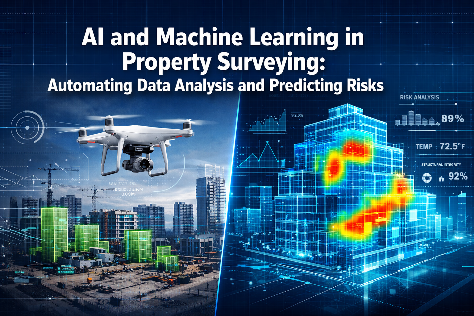
Picture this: a construction project spanning hundreds of acres, with surveyors traditionally spending weeks manually analyzing terrain data, cross-referencing historical records, and attempting to predict potential risks. Now imagine that same process completed in hours, with greater accuracy and comprehensive risk forecasting. This isn't science fiction—it's the reality of AI and Machine Learning in Property Surveying: Automating Data Analysis and Predicting Risks in 2026.
The property surveying industry stands at a transformative crossroads. Artificial intelligence and machine learning technologies are fundamentally reshaping how surveyors collect, process, and interpret data. These advanced systems can now process massive datasets in minutes, detect subtle patterns invisible to human analysis, monitor terrain changes with millimeter precision, and forecast risks like flooding and landslides before they become catastrophic problems. For construction projects, development planning, and property assessments, this technological revolution is streamlining workflows and delivering unprecedented insights.
Key Takeaways
🎯 Rapid Data Processing: Machine learning algorithms can analyze massive surveying datasets in a fraction of the time required by traditional methods, identifying patterns and changes that would take humans weeks to detect.
🔮 Predictive Risk Assessment: AI tools can forecast potentially devastating situations including flooding, landslides, and structural failures by analyzing historical data, environmental factors, and real-time monitoring inputs.
🚁 Enhanced Field Capabilities: The combination of autonomous drones and AI-powered image analysis extends surveyors' reach to previously inaccessible areas while delivering intelligent interpretation of spatial data.
📊 Integrated Digital Workflows: Modern surveying now operates through fully integrated digital ecosystems combining AI, cloud platforms, real-time 3D modeling, and instant reporting capabilities.
💡 Human-AI Collaboration: Rather than replacing professional surveyors, AI enhances their capabilities, with the combined approach becoming the industry standard for delivering speed, precision, and comprehensive risk analysis.
Understanding AI and Machine Learning in Property Surveying: Automating Data Analysis and Predicting Risks
What Makes AI Different from Traditional Surveying Methods?
Traditional property surveying relies heavily on manual data collection, human interpretation, and time-intensive analysis processes. Surveyors physically measure properties, record observations, and spend considerable time cross-referencing information to identify potential issues. While this approach has served the industry well for decades, it faces inherent limitations in processing speed, pattern recognition, and predictive capabilities.
Artificial intelligence and machine learning fundamentally transform this paradigm. These technologies can:
- Process thousands of data points simultaneously rather than sequentially
- Identify subtle correlations across multiple datasets that human analysis might miss
- Learn from historical patterns to improve prediction accuracy over time
- Operate continuously without fatigue or diminishing attention
- Integrate diverse data sources including satellite imagery, sensor networks, historical records, and environmental databases
The shift represents more than just automation—it's an evolution toward intelligent data interpretation that enhances human expertise rather than replacing it.
The Core Technologies Powering Modern Property Surveying
Several interconnected technologies form the foundation of AI-driven property surveying:
Machine Learning Algorithms: These systems analyze patterns in historical surveying data to recognize features, detect anomalies, and make predictions about future conditions. The algorithms continuously improve as they process more information[1].
Computer Vision: Advanced image recognition enables AI to interpret drone footage, satellite imagery, and photographic surveys, automatically identifying structural elements, vegetation encroachment, boundary markers, and potential defects[4].
Natural Language Processing: AI can now extract valuable insights from textual property descriptions, historical survey reports, planning documents, and maintenance records, integrating this information with numerical and visual data[2].
Predictive Analytics: By combining current survey data with historical trends, environmental factors, and statistical modeling, AI systems forecast future risks and property conditions with increasing accuracy[1].
Real-Time Data Integration: Cloud-based platforms enable instant synthesis of data from multiple sources, providing surveyors with comprehensive, up-to-date information accessible from any location[5].
How AI Processes Massive Datasets to Detect Patterns in Property Surveying
The Challenge of Big Data in Modern Surveying
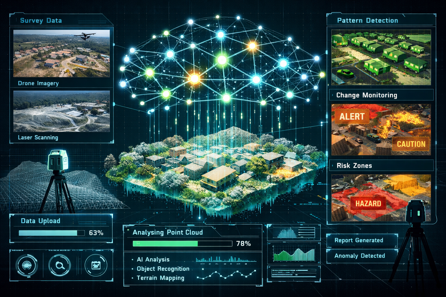
Contemporary property surveying generates enormous volumes of data. A single drone survey of a large construction site can produce millions of data points. Laser scanning technology captures detailed 3D information at unprecedented resolution. Satellite monitoring provides continuous updates on terrain changes, vegetation growth, and environmental conditions.
Processing this information manually would be practically impossible. Even with traditional digital tools, analyzing such datasets requires significant time and specialized expertise. This is where machine learning algorithms demonstrate their transformative value.
Machine Learning's Data Processing Capabilities
Machine learning excels at identifying patterns within complex, multi-dimensional datasets. When applied to property surveying, these algorithms can:
Classify Terrain Features: AI systems automatically categorize land features, identifying slopes, water bodies, vegetation types, built structures, and geological formations from survey data[3].
Detect Anomalies: By establishing baseline patterns, machine learning identifies deviations that might indicate problems—subsidence, unauthorized construction, boundary encroachments, or environmental degradation.
Track Changes Over Time: Comparing sequential surveys, AI precisely measures changes in terrain elevation, structural movement, vegetation growth, or water levels with millimeter accuracy[1].
Correlate Multiple Variables: Machine learning synthesizes diverse data types—soil composition, rainfall patterns, historical incidents, construction activities—to understand complex relationships affecting property conditions[2].
The speed advantage is remarkable. Tasks that might require weeks of manual analysis can be completed in hours or even minutes, enabling surveyors to deliver insights when they're most valuable for decision-making.
Practical Applications in Construction Projects
For construction projects, AI-powered data analysis delivers concrete benefits:
📍 Site Assessment: Before breaking ground, AI analyzes topographical data, soil conditions, drainage patterns, and environmental factors to identify optimal building locations and potential challenges.
📐 Volumetric Calculations: Machine learning accurately calculates earthwork volumes, material quantities, and site preparation requirements from 3D survey data, improving cost estimation and project planning.
🔍 Progress Monitoring: Regular drone surveys processed by AI track construction progress against plans, automatically identifying deviations, delays, or quality issues requiring attention.
⚠️ Safety Compliance: AI systems monitor site conditions for safety hazards, unauthorized access, or environmental compliance issues, alerting project managers to potential problems.
When conducting a building survey or property inspection, these AI capabilities significantly enhance the depth and accuracy of assessments.
Monitoring Terrain Changes and Forecasting Risks Like Flooding
Real-Time Change Detection and Monitoring
One of the most powerful applications of AI and Machine Learning in Property Surveying: Automating Data Analysis and Predicting Risks is continuous terrain monitoring. Traditional surveying provides snapshots at specific moments, but AI-enabled systems track changes as they occur.
Automated change detection works by:
- Establishing baseline conditions from initial comprehensive surveys
- Continuously comparing new data from sensors, satellites, or periodic drone flights
- Automatically flagging deviations that exceed predetermined thresholds
- Generating alerts for significant changes requiring human review
This capability proves particularly valuable for:
- Slope stability monitoring on hillside properties or construction sites
- Settlement tracking for buildings and infrastructure
- Coastal erosion assessment for waterfront properties
- Vegetation encroachment affecting boundaries or structures
- Water level changes in flood-prone areas
The rapid adoption of mobile mapping technologies is redefining data collection and processing, enabling creation of accurate 3D models that enhance understanding of complex urban spaces—critical as cities become increasingly vertical[3].
Predictive Risk Assessment for Flooding
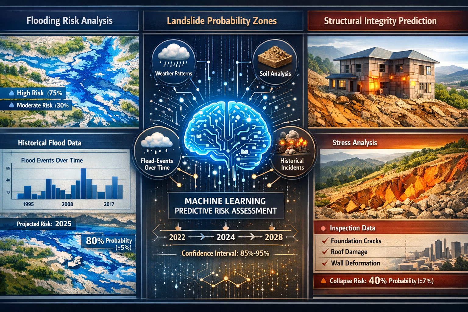
Flooding represents one of the most significant risks to property, and AI has revolutionized flood prediction capabilities. Machine learning models analyze multiple factors simultaneously:
Historical Flood Data: AI examines past flooding events, identifying patterns related to rainfall intensity, duration, seasonal factors, and geographical vulnerabilities.
Topographical Analysis: Detailed terrain modeling reveals water flow patterns, drainage pathways, accumulation zones, and natural flood defenses or vulnerabilities.
Hydrological Modeling: Machine learning integrates river levels, groundwater conditions, soil saturation, and drainage capacity to predict flooding probability under various scenarios.
Climate and Weather Integration: AI systems incorporate weather forecasts, climate trends, and extreme event predictions to assess short-term and long-term flood risks[1].
Infrastructure Considerations: The models account for drainage systems, flood defenses, urban development impacts, and maintenance conditions affecting flood resilience.
By processing these diverse inputs, AI tools can predict potentially devastating situations including flooding with increasing accuracy, though these predictive risk tools remain in early development stages[1]. For property buyers considering a homebuyers report or Level 2 survey, understanding flood risk has never been more important.
Landslide and Subsidence Prediction
Beyond flooding, AI excels at forecasting other geological risks:
Landslide Risk Assessment: Machine learning analyzes slope angles, soil composition, vegetation cover, rainfall patterns, and historical incidents to identify properties at risk of landslides or slope failure.
Subsidence Detection: By comparing sequential surveys with millimeter precision, AI identifies subtle ground movement that might indicate subsidence—whether from natural geological processes, mining activities, or soil conditions. This is particularly relevant for properties where subsidence is a concern.
Structural Movement Monitoring: AI tracks building movement, identifying patterns that might indicate foundation problems, soil settlement, or structural stress before they become critical.
The probabilistic understanding provided by machine learning represents a significant advance over binary risk assessments. Rather than simply categorizing properties as "at risk" or "safe," AI systems provide nuanced probability estimates under different scenarios, enabling more informed decision-making[2].
Streamlining Workflows for Surveyors in Construction Projects
The Integrated Digital Workflow Revolution
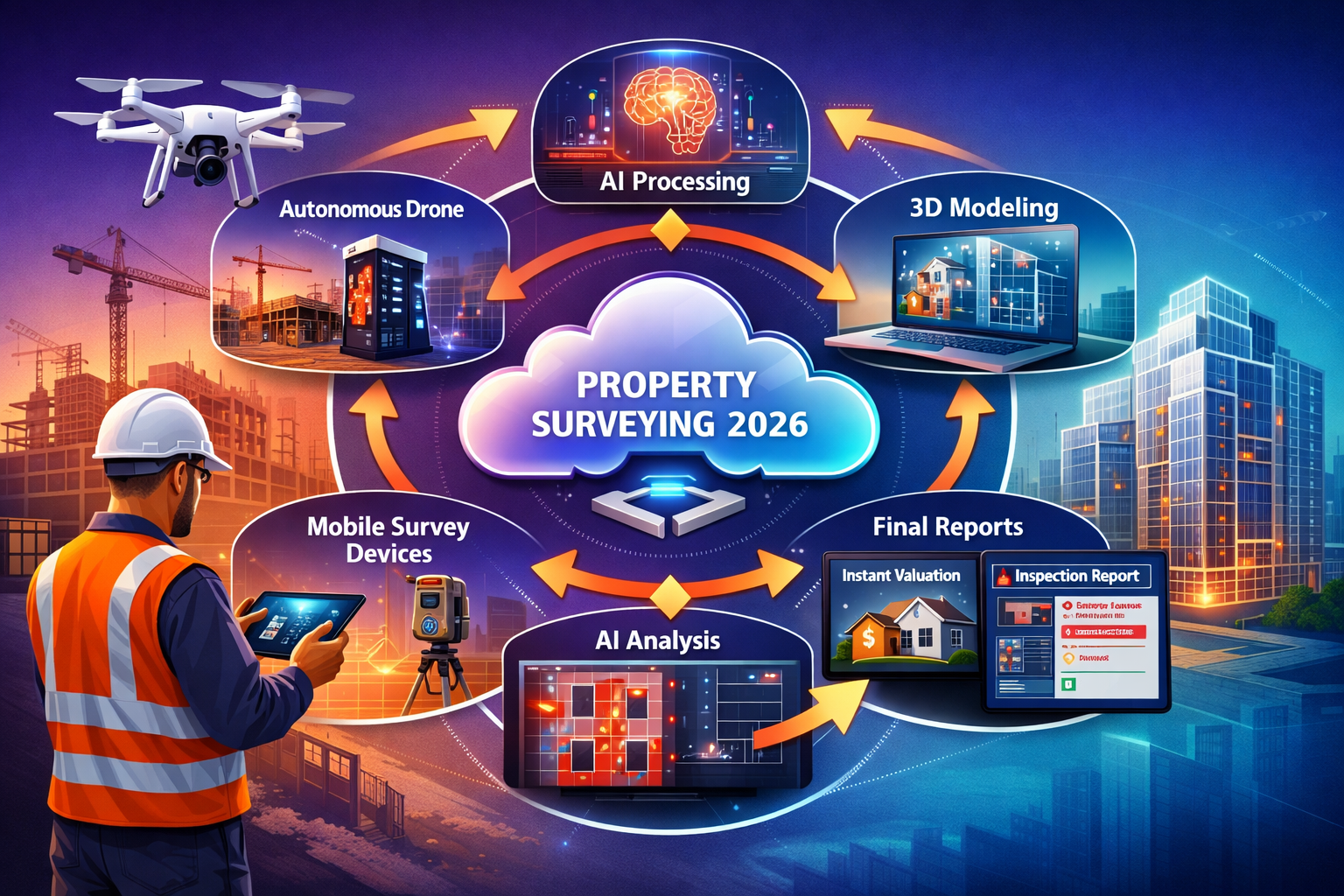
The future of surveying technology is moving toward fully integrated digital workflows that combine AI, cloud platforms, autonomous drones, and real-time 3D modeling to deliver instant, highly accurate survey data[1]. This integration fundamentally transforms how surveyors operate on construction projects.
A typical modern workflow includes:
🚁 Autonomous Data Collection: Drones follow pre-programmed flight paths, capturing comprehensive imagery and spatial data without constant human supervision. When AI is applied to imagery and spatial data collected by drones, interpretation becomes more intelligent, with drones extending surveyors' reach to rooftops, large estates, and otherwise inaccessible areas[4].
☁️ Cloud-Based Processing: Survey data uploads automatically to cloud platforms where AI algorithms process, analyze, and organize the information, making it accessible to project teams in real-time.
🏗️ 3D Model Generation: AI systems automatically create detailed 3D models from survey data, providing visual representations that stakeholders can explore and annotate collaboratively.
📊 Automated Reporting: Machine learning generates preliminary survey reports, highlighting key findings, potential issues, and areas requiring professional review, dramatically reducing report preparation time.
📱 Mobile Access: Project teams access survey data, models, and reports through mobile devices on-site, enabling immediate decision-making without returning to offices.
This integrated approach eliminates the traditional bottlenecks between data collection, processing, analysis, and reporting that previously consumed significant time in construction workflows.
Time and Cost Efficiency Gains
The efficiency improvements from AI-powered surveying are substantial:
| Traditional Method | AI-Enhanced Method | Time Saving |
|---|---|---|
| Manual data processing: 3-5 days | Automated processing: 2-4 hours | 85-95% |
| Pattern analysis: 1-2 weeks | ML pattern detection: Hours | 90%+ |
| Report preparation: 2-3 days | Automated drafting: Same day | 70-80% |
| Risk assessment: Multiple specialists | Integrated AI analysis: Single workflow | 60-75% |
These time savings translate directly to cost reductions and faster project timelines. Construction projects can proceed with greater confidence, armed with comprehensive survey data and risk assessments delivered when needed for critical decisions.
For property transactions, the speed advantage proves equally valuable. Buyers can obtain detailed property assessments quickly, potentially negotiating better prices based on comprehensive risk analysis.
Enhanced Accuracy and Consistency
Beyond speed, AI delivers improved accuracy through:
Elimination of Human Error: Automated data processing removes transcription mistakes, calculation errors, and inconsistent interpretation that can occur with manual methods.
Standardized Analysis: Machine learning applies consistent analytical criteria across all projects, ensuring comparable results and reducing subjective variation.
Comprehensive Coverage: AI systems examine every data point systematically, ensuring nothing is overlooked—a challenge when humans review massive datasets.
Quality Control: Automated validation checks identify anomalies, inconsistencies, or data quality issues that might compromise survey accuracy.
This consistency proves particularly valuable for organizations managing multiple properties or ongoing construction portfolios, where standardized assessment criteria enable meaningful comparisons and trend analysis.
AI-Driven Property Valuations and Risk Management
Dynamic Real-Time Valuation Models
While traditional property valuations provide static snapshots, AI-driven property valuations now deliver continuously updated assessments that adjust in real time to shifting market forces[2]. This represents a fundamental shift in how properties are valued and risks are assessed.
Machine learning models now synthesize diverse data types including:
- Economic indicators: Interest rates, employment statistics, inflation trends, mortgage availability
- Environmental factors: Flood risk, air quality, climate projections, urban development projects
- Neighborhood metrics: School ratings, crime statistics, transport links, amenity access
- Property characteristics: Size, condition, features, age, renovation history
- Market dynamics: Recent sales, listing trends, demand patterns, seasonal variations
By processing these multifaceted inputs, AI uncovers correlations humans might miss[2], providing more nuanced and accurate valuations that reflect the complex reality of property markets.
Scenario-Based Risk Analysis
Perhaps most powerfully, machine learning systems can simulate potential scenarios and provide probabilistic understanding of property value under different conditions[2]. For example:
💰 Interest Rate Scenarios: How might rising mortgage rates affect demand and values in specific neighborhoods?
🏗️ Development Impact: What value changes might result from planned infrastructure projects or zoning changes?
🌊 Environmental Changes: How could increasing flood risk or climate adaptation measures affect property values over time?
📈 Market Shifts: What happens to valuations if employment patterns, remote work trends, or demographic shifts continue?
This predictive scenario analysis enables more sophisticated risk management for all stakeholders—buyers, sellers, lenders, insurers, and developers—providing insights that inform better decisions.
Applications for Lenders and Insurers
The financial services sector has embraced AI-powered surveying and valuation for enhanced risk management:
Mortgage Lending: Lenders can evaluate the likelihood of default based on AI-projected property values, enabling more robust risk assessments and improved portfolio performance compared to traditional evaluation methods[2].
Insurance Underwriting: AI systems assess property-specific risks—flooding, subsidence, structural issues—with unprecedented precision, enabling more accurate premium pricing and claims prediction.
Portfolio Management: Investment funds use machine learning to monitor property portfolios continuously, identifying emerging risks or opportunities across large holdings.
iBuyer Models: Companies are using machine learning algorithms to generate near-instant cash offers on homes, cutting through weeks of negotiation, appraisal, and uncertainty, representing one of the most visible outcomes of ML adoption in real estate[2].
For property buyers seeking to understand potential price reductions after surveys or renegotiation opportunities, AI-powered valuations provide data-driven support for negotiations.
The Human-AI Collaboration Model in Professional Surveying
Why AI Enhances Rather Than Replaces Surveyors
Despite the impressive capabilities of AI and machine learning, the human-AI collaboration approach is becoming the industry standard rather than full automation[2]. Professional surveyors remain essential for several critical reasons:
🎓 Professional Judgment: Unique or unusual properties require experienced interpretation that AI systems, trained on typical cases, may not handle well. Complex boundary disputes, heritage properties, or unusual construction methods benefit from human expertise.
🔍 Context and Nuance: Surveyors understand local market conditions, regulatory environments, and contextual factors that may not be captured in datasets. They can identify when AI predictions seem inconsistent with on-ground reality.
🤝 Client Communication: Property surveying involves significant client interaction, explanation of findings, and guidance on implications—skills that require human empathy, communication ability, and relationship building.
⚖️ Ethical and Legal Responsibility: Professional surveyors carry legal responsibilities and ethical obligations that cannot be delegated to algorithms. They must ensure compliance with standards, regulations, and professional codes.
🔧 Quality Assurance: Experienced surveyors review AI-generated analyses, validating findings, identifying potential errors, and ensuring comprehensive coverage before reports are finalized.
The most effective approach combines AI's processing power and pattern recognition with human expertise, judgment, and accountability. This partnership delivers superior results compared to either approach alone.
Practical Implementation in Surveying Practices
Forward-thinking surveying practices are implementing AI technologies strategically:
Phase 1 – Data Collection Enhancement: Adopting drones, mobile mapping, and automated sensors to capture more comprehensive data more efficiently.
Phase 2 – Processing Automation: Implementing AI-powered processing tools to handle routine data analysis, freeing surveyors for higher-value interpretation and client service.
Phase 3 – Predictive Integration: Incorporating machine learning risk assessment and predictive analytics into standard survey deliverables, providing clients with forward-looking insights.
Phase 4 – Workflow Integration: Creating seamless digital workflows that combine AI automation with professional review checkpoints, ensuring quality while maximizing efficiency.
Successful implementation requires investment in training, ensuring surveyors understand AI capabilities and limitations, can interpret machine learning outputs effectively, and leverage these tools to enhance their professional services.
Challenges and Limitations of AI in Property Surveying
Data Quality and Availability Issues
AI and machine learning systems are only as good as the data they process. Several challenges affect implementation:
Historical Data Gaps: Predictive models require extensive historical data, which may not exist for all locations or property types, limiting accuracy in some contexts.
Data Standardization: Inconsistent data formats, measurement standards, or recording practices across different sources complicate integration and analysis.
Bias in Training Data: If AI systems are trained primarily on data from specific property types or locations, they may perform poorly on underrepresented cases.
Real-Time Data Access: Effective monitoring and prediction require continuous data feeds, which may not be available or affordable for all applications.
Addressing these limitations requires ongoing investment in data infrastructure, standardization efforts, and careful validation of AI outputs against ground truth.
Technical and Implementation Barriers
Organizations face practical challenges adopting AI technologies:
💷 Initial Investment: Advanced surveying equipment, software platforms, and AI tools require significant capital investment that may be prohibitive for smaller practices.
🎓 Skills Gap: Effective use of AI tools requires technical expertise that traditional surveying education may not provide, necessitating training and potentially new hiring.
🔄 Legacy System Integration: Existing workflows, software, and data systems may not integrate easily with new AI platforms, creating implementation complexity.
🔐 Data Security: Cloud-based platforms and extensive data collection raise privacy and security concerns that must be addressed through robust cybersecurity measures.
Regulatory and Professional Standards
The surveying profession operates within established regulatory frameworks that are adapting to AI adoption:
Professional Liability: Questions remain about responsibility when AI systems contribute to survey findings—who bears liability if machine learning predictions prove inaccurate?
Standards Compliance: Professional bodies like RICS are developing guidelines for AI use in surveying, but standards continue evolving as technology advances[4].
Transparency Requirements: Clients and regulators increasingly demand transparency about how AI systems reach conclusions, requiring explainable AI approaches rather than "black box" algorithms.
Validation Requirements: Professional standards may require human validation of AI outputs, limiting automation potential in certain contexts.
Navigating these challenges requires active engagement with professional bodies, regulatory authorities, and industry peers to develop appropriate frameworks for responsible AI adoption.
Future Trends: What's Next for AI and Machine Learning in Property Surveying
Emerging Technologies on the Horizon
The evolution of AI and Machine Learning in Property Surveying: Automating Data Analysis and Predicting Risks continues rapidly, with several emerging trends shaping the next phase:
🤖 Autonomous Survey Systems: Fully autonomous drones and robotic systems that conduct complete surveys without human intervention, automatically navigating complex environments and adapting to conditions[3].
🧠 Advanced Neural Networks: Deep learning architectures that can interpret increasingly complex patterns, including subtle structural deterioration, material degradation, or environmental stress indicators.
🌐 Digital Twin Integration: Creating comprehensive digital twins of properties and developments that continuously update based on sensor data, enabling real-time monitoring and predictive maintenance[5].
📡 IoT Sensor Networks: Widespread deployment of low-cost sensors providing continuous monitoring of structural movement, moisture levels, temperature variations, and environmental conditions.
🔮 Enhanced Predictive Models: Machine learning systems that forecast not just immediate risks but long-term property performance, maintenance requirements, and lifecycle costs with increasing accuracy.
Integration with Broader PropTech Ecosystem
AI-powered surveying is becoming part of a larger property technology ecosystem that includes:
- Smart building management systems that optimize operations based on continuous monitoring
- Blockchain-based property records providing verified, immutable survey and transaction histories
- Augmented reality tools enabling clients to visualize survey findings overlaid on actual properties
- Automated compliance systems that check survey data against building regulations and planning requirements
This integration creates comprehensive digital property intelligence that serves stakeholders throughout the property lifecycle—from initial development through ownership, maintenance, and eventual sale or redevelopment.
The Path to Industry-Wide Adoption
For AI and machine learning to achieve full potential in property surveying, several developments are necessary:
Standardization: Industry-wide data standards, AI validation protocols, and quality benchmarks that ensure consistency and reliability.
Education: Integration of AI literacy into surveying education and professional development, preparing the next generation of surveyors for technology-enhanced practice.
Accessibility: Development of affordable, user-friendly AI tools that smaller practices can adopt, preventing technology from creating competitive disadvantages.
Collaboration: Ongoing dialogue between technology providers, surveying professionals, regulators, and clients to ensure AI development meets real-world needs and maintains professional standards.
Evidence Building: Continued research demonstrating AI effectiveness, accuracy, and value proposition to drive broader confidence and adoption.
The trajectory is clear: AI and machine learning will become standard components of professional surveying practice, much as digital photography, GPS, and CAD software have become essential tools that modern surveyors take for granted.
Conclusion: Embracing the AI Revolution in Property Surveying
The integration of AI and Machine Learning in Property Surveying: Automating Data Analysis and Predicting Risks represents far more than incremental improvement—it's a fundamental transformation of how the industry operates. From processing massive datasets in hours rather than weeks, to predicting floods and landslides before they occur, to streamlining construction workflows with integrated digital platforms, these technologies deliver tangible benefits that enhance professional practice and serve clients better.
The evidence is compelling: machine learning can identify patterns humans miss, process information at unprecedented speed, and provide predictive insights that enable proactive risk management. When combined with autonomous drones extending surveyors' reach, real-time 3D modeling enhancing visualization, and cloud platforms enabling instant collaboration, the result is a more efficient, accurate, and valuable surveying service.
Yet technology alone isn't the answer. The human-AI collaboration model emerging as industry standard recognizes that professional judgment, contextual understanding, client relationships, and ethical accountability remain essential. The most successful surveying practices will be those that strategically integrate AI capabilities while maintaining the professional expertise that clients depend upon.
Actionable Next Steps
For surveying professionals looking to embrace these technologies:
✅ Assess Current Capabilities: Evaluate existing workflows to identify areas where AI could deliver immediate efficiency or accuracy improvements.
✅ Invest in Education: Develop AI literacy through training, professional development, and engagement with technology providers to understand capabilities and limitations.
✅ Start Strategically: Begin with focused implementations—perhaps drone-based data collection or automated processing—rather than attempting comprehensive transformation immediately.
✅ Build Partnerships: Collaborate with technology providers, other practices, and professional bodies to share knowledge and develop best practices.
✅ Communicate Value: Help clients understand how AI-enhanced surveying delivers better insights, faster turnaround, and more comprehensive risk assessment.
For property buyers and developers:
✅ Seek AI-Enhanced Services: When selecting surveyors, inquire about their use of advanced technologies and how these enhance the surveys they provide, whether you need a homebuyers report or building survey.
✅ Understand Capabilities: Ask how AI contributes to risk prediction, data analysis, and the insights provided in your survey report.
✅ Leverage Insights: Use the predictive risk assessments and comprehensive data analysis AI enables to make more informed decisions about property purchases, development plans, or risk management.
✅ Plan for the Future: Consider how AI-powered continuous monitoring might benefit property management and maintenance planning beyond the initial survey.
The revolution in property surveying is not coming—it's already here. The question is not whether to embrace AI and machine learning, but how quickly and effectively to integrate these powerful tools into professional practice. Those who do so thoughtfully, maintaining professional standards while leveraging technological capabilities, will be best positioned to serve clients, manage risks, and thrive in the evolving landscape of property surveying in 2026 and beyond.
Whether you're a professional surveyor, property developer, construction manager, or prospective buyer, understanding and engaging with these technologies is no longer optional—it's essential for navigating the modern property market with confidence and success.
References
[1] The Future Of Land Surveying Technology And Upcoming Trends In 2026 – https://metricop.com/blogs/land-surveying/the-future-of-land-surveying-technology-and-upcoming-trends-in-2026
[2] How Ai And Machine Learning Are Reshaping Property Valuations In 2026 – https://www.thepaintedhinge.com/how-ai-and-machine-learning-are-reshaping-property-valuations-in-2026/
[3] Land Surveying Propelled Into The Future With Ai And Drones – https://resource-erectors.com/land-surveying-propelled-into-the-future-with-ai-and-drones/
[4] What Surveyors Think Ai – https://ww3.rics.org/uk/en/modus/technology-and-data/surveying-tools/what-surveyors-think-ai.html
[5] Doubling Down On Digital – https://amerisurv.com/2026/02/01/doubling-down-on-digital/