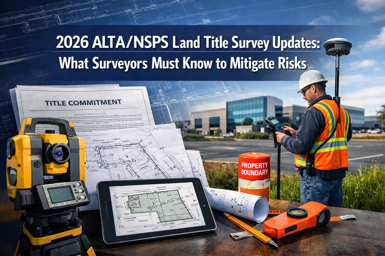
The landscape of land title surveying has fundamentally shifted. As of February 23, 2026, every surveyor conducting land title surveys must comply with the new 2026 Minimum Standard Detail Requirements adopted by the American Land Title Association (ALTA) and the National Society of Professional Surveyors (NSPS). These updated standards represent the most significant changes to surveying practices in years, particularly regarding how surveyors research adjoining properties, document evidence of possession, and communicate findings to stakeholders.
Understanding the 2026 ALTA/NSPS Land Title Survey Updates: What Surveyors Must Know to Mitigate Risks is no longer optional—it's essential for protecting your professional reputation, reducing liability exposure, and delivering the comprehensive service that commercial real estate professionals now expect. After more than three years of development by a joint work group of surveyors and title professionals, these standards introduce clearer requirements, enhanced documentation protocols, and modernized approaches that embrace emerging technologies[3].
Key Takeaways
- ✅ Effective Date: The 2026 standards apply to all land title survey contracts executed on or after February 23, 2026, replacing the 2021 requirements[3]
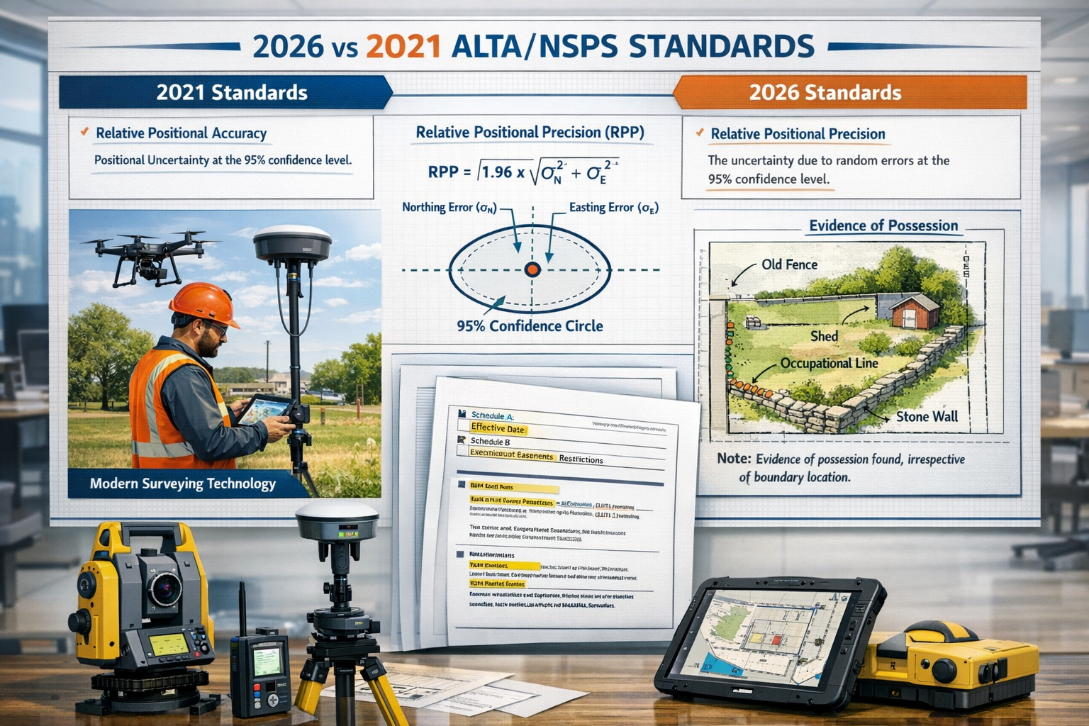
- 📊 Revised RPP Definition: The most significant change involves a clearer definition of Relative Positional Precision with improved explanations for non-technical audiences[1]
- 🔍 Proximity Clarification: Section 5.C.i. now explicitly states that evidence of possession or occupation must be shown "regardless of proximity to perimeter boundary lines," eliminating previous confusion[3]
- 🛠️ Technology Flexibility: New language referencing "practices generally recognized as acceptable by the surveying profession" allows surveyors to utilize emerging technologies including drones, AI, and LiDAR[1]
- 📝 Enhanced Documentation: Surveyors must now provide explicit reasoning for decisions previously left implied, improving transparency and communication with title companies and property owners[4]
Understanding the 2026 ALTA/NSPS Land Title Survey Updates: Background and Development
The Evolution of Survey Standards
The journey to the 2026 standards began over three years ago when ALTA and NSPS recognized the need to update the 2021 Minimum Standard Detail Requirements. The Joint ALTA/NSPS Work Group, comprising roughly equal numbers of professional surveyors and title professionals, met semi-annually throughout the development process to address emerging challenges, technological advances, and feedback from practitioners in the field[3].
Currently chaired by Todd D'Amico, PS of Oklahoma, the Work Group focused on creating standards that balance precision with practicality, ensuring that surveyors can deliver accurate, comprehensive surveys while adapting to modern tools and methodologies[3]. This collaborative approach between surveyors and title professionals has resulted in standards that better serve all stakeholders in commercial real estate transactions.
Why These Updates Matter Now
The commercial real estate industry has undergone dramatic changes since 2021. Property transactions have become more complex, technology has advanced rapidly, and the need for clear communication between professional surveyor services and other stakeholders has intensified. The 2026 updates address these realities head-on.
Key drivers behind the updates include:
- 🏢 Increased complexity in commercial property transactions
- 💻 Rapid advancement in surveying technology and methodologies
- ⚖️ Growing litigation risks related to boundary disputes and easement conflicts
- 📋 Demand for greater transparency from title insurers and lenders
- 🌐 Need for standardization across different jurisdictions and practice areas
Understanding what does a surveyor do in this evolving landscape requires familiarity with these updated standards and their practical implications.
Major Changes in the 2026 ALTA/NSPS Land Title Survey Updates: What Surveyors Must Know
Revised Definition of Relative Positional Precision (RPP)
The most significant technical change in the 2026 standards involves the definition and explanation of Relative Positional Precision (RPP). This measurement determines how accurately surveyors locate property boundaries relative to each other, and the new standards provide clearer guidance for both technical and non-technical audiences[1].
What Changed:
- More precise mathematical definitions of RPP calculations
- Clearer explanations suitable for title professionals, attorneys, and property owners
- Enhanced documentation requirements showing how RPP was achieved
- Better alignment with modern GPS and total station capabilities
Why It Matters:
RPP directly impacts the reliability of boundary determinations. When surveyors can clearly communicate the precision of their measurements, title companies can make better-informed decisions about insurability, and property owners gain confidence in boundary locations.
Implementation Checklist for RPP Compliance:
| Task | Action Required | Documentation Needed |
|---|---|---|
| Calculate RPP | Use approved methodologies consistent with current technology | Mathematical calculations and methodology statement |
| Explain RPP | Provide clear explanation in non-technical language | Written explanation on survey plat or in separate report |
| Document Equipment | Record all equipment used and calibration dates | Equipment log and calibration certificates |
| Show Compliance | Demonstrate that RPP meets or exceeds standard requirements | Comparison table or compliance statement |
Section 5.C.i.: Evidence of Possession Regardless of Proximity
One of the most practically significant changes addresses a source of confusion in the 2021 standards. Section 5.C.i. now explicitly states that surveyors must show evidence of possession or occupation "regardless of proximity to perimeter boundary lines"[3].
Previous Confusion:
Under the 2021 standards, some surveyors interpreted requirements as applying only to evidence within approximately five feet of boundary lines. This created inconsistencies in survey deliverables and occasionally resulted in important possession evidence being omitted from surveys.
2026 Clarification:
The updated language removes any ambiguity. Surveyors must now document all evidence of possession or occupation observed during the survey, including:
- 🏗️ Fences, walls, and other physical barriers
- 🚗 Paved areas, driveways, and parking lots
- 🌳 Landscaping improvements and plantings
- 🏢 Building encroachments or setback issues
- 📦 Storage areas, sheds, and accessory structures
- 🚧 Any improvements suggesting occupancy or use
This change significantly impacts survey scope and field time requirements. Surveyors must now conduct more thorough inspections of the entire property, not just areas near boundary lines.
Section 5.E.iv.: Utility Locations and Easement Evidence
Section 5.E.iv. underwent modification to address utility location and easement evidence requirements, with some provisions reverting to original intent from earlier standard versions[3]. This section has been particularly challenging for surveyors due to the proliferation of underground utilities and the varying quality of utility records.
Updated Requirements:
- More explicit guidance on what constitutes adequate utility evidence
- Clarification on when physical utility locations must be shown versus when record information suffices
- Better alignment with practical field conditions and available technology
- Recognition that some utilities cannot be precisely located without destructive investigation
Best Practices for Compliance:
- Request utility records from all relevant providers early in the survey process
- Use available technology (ground-penetrating radar, electromagnetic locators) when appropriate
- Clearly note on the survey which utilities are shown from records versus field location
- Document any discrepancies between record information and observed conditions
- Include appropriate disclaimers regarding utilities that cannot be verified without excavation
Flexibility for Emerging Technologies
Perhaps the most forward-thinking change in the 2026 standards is the new reference to "practices generally recognized as acceptable by the surveying profession"[1]. This language eliminates the need for standards to prescribe specific procedures and tools, allowing surveyors to adopt emerging technologies as they become accepted practice.
Technologies Now More Clearly Supported:
- 🚁 Drones and UAVs for aerial photography and photogrammetry
- 🤖 Artificial Intelligence for data processing and analysis
- 📡 LiDAR for detailed topographic and structural surveys
- 📱 Mobile mapping systems for efficient data collection
- 💾 Cloud-based platforms for data management and collaboration
This flexibility ensures that the standards remain relevant as technology continues to evolve, without requiring constant revisions to accommodate new tools and methodologies.
Compliance Steps for the 2026 ALTA/NSPS Land Title Survey Updates: What Surveyors Must Know to Mitigate Risks
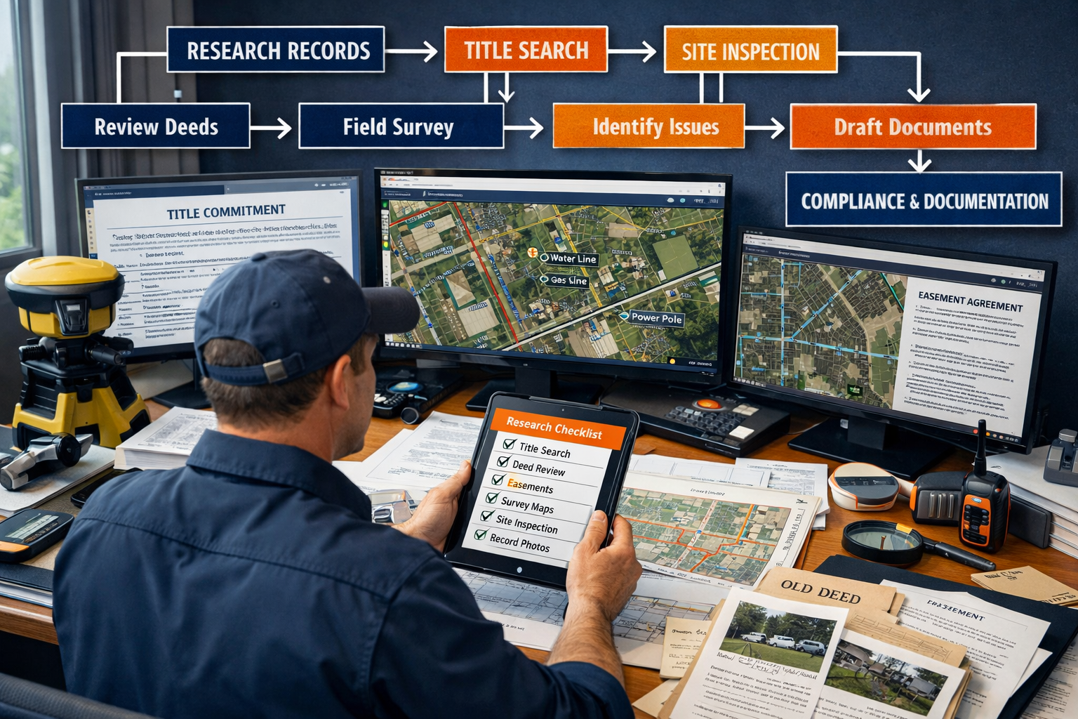
Pre-Survey Research and Adjoining Property Investigation
The 2026 standards place increased emphasis on thorough research before fieldwork begins. Surveyors must obtain and review comprehensive documentation, including a copy of the most recent title commitment or other title evidence satisfactory to the insurer[3].
Comprehensive Research Checklist:
✅ Title Documentation
- Current title commitment or title policy
- All recorded easements, covenants, and restrictions
- Deed descriptions for subject property and adjoining parcels
- Plat records and subdivision documents
✅ Adjoining Property Research
- Deeds for all immediately adjoining properties
- Survey records for neighboring parcels
- Recorded agreements affecting boundaries
- Evidence of shared improvements or common areas
✅ Public Records Investigation
- Zoning ordinances and setback requirements
- Building permits and certificates of occupancy
- Utility company records and as-built drawings
- Municipal infrastructure plans and right-of-way records
✅ Historical Research
- Previous surveys of the subject property
- Aerial photography showing historical development
- Tax maps and assessor records
- Any litigation involving property boundaries
This comprehensive approach to research helps surveyors identify potential issues before fieldwork begins, reducing the likelihood of costly resurveys or professional liability claims. Similar to how thorough research benefits building survey work, land title surveys require meticulous preparation.
Field Investigation and Documentation
The 2026 standards require more comprehensive field documentation than previous versions. Surveyors must now explain reasoning that was previously left implicit, creating a more transparent record of their work[4].
Enhanced Field Documentation Requirements:
Boundary Evidence:
- Photograph all found monuments and boundary markers
- Document the condition and type of each monument
- Note any discrepancies between record and measured locations
- Explain any decisions to accept or reject boundary evidence
Possession and Occupation Evidence:
- Document all improvements regardless of distance from boundaries
- Photograph fences, walls, and other physical features
- Note any apparent encroachments or setback violations
- Record evidence of maintenance, use, or occupancy
Utility and Easement Evidence:
- Locate visible utility infrastructure
- Document utility markings and surface evidence
- Note any conflicts between easements and improvements
- Photograph utility installations and access points
Inaccessible Areas:
- Clearly identify any areas that could not be accessed
- Explain reasons for inaccessibility
- Document attempts made to gain access
- Note any assumptions made regarding inaccessible areas
This level of documentation supports the surveyor's conclusions and provides valuable information to title companies, attorneys, and property owners. The approach mirrors best practices in stock condition surveys, where comprehensive documentation is essential.
Survey Plat Preparation and Explanation
The 2026 standards emphasize clearer documentation, more transparency, and better communication between surveyors, title companies, and property owners[1][4]. This requires surveyors to provide explicit explanations on the survey plat or in accompanying reports.
Required Explanations and Clarifications:
📝 Legal Description Issues
- When a new legal description was created and why
- Any discrepancies between deed description and measured boundaries
- Basis for any corrections or adjustments to record information
📝 Precision and Accuracy Statements
- Clear explanation of RPP and what it means
- Description of methods and equipment used
- Any limitations on precision due to field conditions
📝 Access and Investigation Limitations
- Areas that could not be accessed and reasons why
- Any investigations that could not be completed
- Recommendations for additional investigation if needed
📝 Easements and Encumbrances
- Location and extent of all easements
- Any conflicts between easements and improvements
- Evidence (or lack thereof) of easement use
📝 Possession and Boundary Issues
- Any discrepancies between occupation and record boundaries
- Potential encroachments or boundary disputes
- Recommendations for resolution of conflicts
This enhanced communication helps prevent misunderstandings and reduces the risk of professional liability claims arising from unclear or ambiguous survey deliverables.
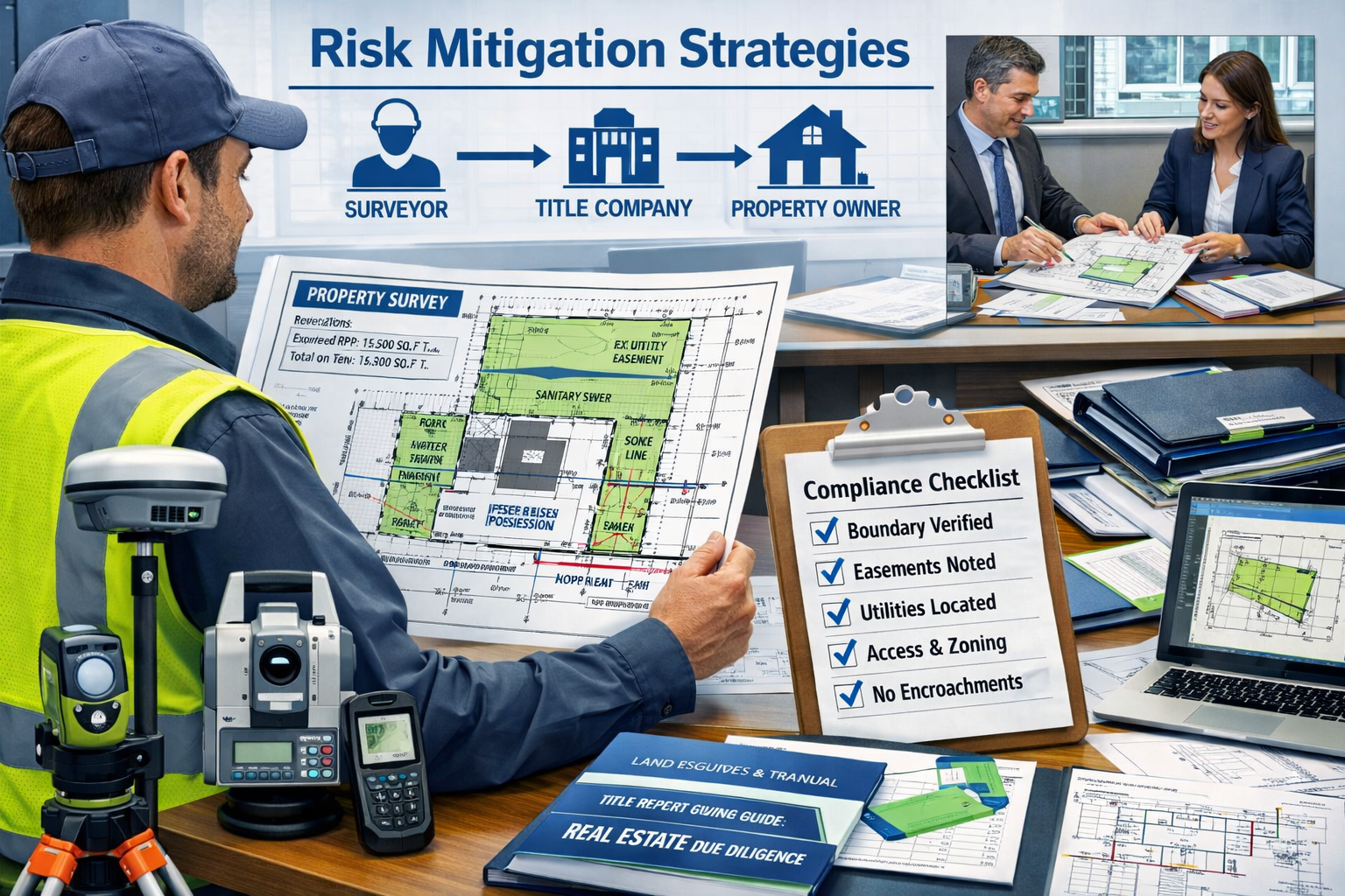
Risk Mitigation Strategies Under the 2026 ALTA/NSPS Land Title Survey Updates
Understanding Your Professional Liability Exposure
The 2026 standards create both opportunities and challenges for professional liability management. While clearer requirements reduce ambiguity, the enhanced documentation and explanation requirements increase the potential for errors or omissions if not properly implemented.
Common Liability Risks:
⚠️ Inadequate Research
- Failing to obtain or review title commitments
- Missing recorded easements or encumbrances
- Insufficient investigation of adjoining properties
- Overlooking relevant public records
⚠️ Incomplete Field Investigation
- Missing evidence of possession or occupation
- Inadequate documentation of inaccessible areas
- Failure to locate or document utilities
- Insufficient photography or field notes
⚠️ Communication Failures
- Unclear or ambiguous survey plat notations
- Inadequate explanation of technical terms
- Failure to highlight potential issues or conflicts
- Missing or incomplete survey narratives
⚠️ Technical Errors
- Incorrect RPP calculations or documentation
- Measurement errors or blunders
- Improper application of standards or specifications
- Use of uncalibrated or inappropriate equipment
Understanding these risks is the first step in developing effective mitigation strategies, similar to how surveyors must understand what to do after a bad report on building survey to manage client expectations.
Implementing Quality Control Procedures
Robust quality control (QC) procedures are essential for compliance with the 2026 standards and professional liability risk management.
Multi-Level QC Framework:
Level 1: Field QC
- Daily review of field notes and measurements
- Verification of monument locations and descriptions
- Confirmation that all required photographs were obtained
- Preliminary check of closure and precision calculations
Level 2: Office QC
- Independent review of all calculations
- Verification that plat complies with 2026 standards
- Confirmation that all required elements are shown
- Review of explanations and narrative for clarity
Level 3: Peer Review
- Review by experienced surveyor not involved in the project
- Assessment of professional judgments and conclusions
- Evaluation of compliance with standards and specifications
- Final check before delivery to client
Level 4: Client Communication
- Pre-delivery discussion of any issues or concerns
- Explanation of survey findings and limitations
- Confirmation that survey meets client's needs
- Documentation of client understanding and acceptance
This systematic approach to quality control helps identify and correct errors before they reach the client, reducing liability exposure and enhancing professional reputation.
Professional Development and Training
Staying current with the 2026 standards requires ongoing education and training. Surveyors should invest in professional development to ensure they understand and can properly implement the updated requirements.
Recommended Training Areas:
📚 Technical Training
- RPP calculation methodologies and documentation
- Modern surveying technology and best practices
- Legal aspects of boundary determination
- Easement research and interpretation
📚 Communication Skills
- Technical writing for non-technical audiences
- Effective survey plat design and notation
- Client consultation and expectation management
- Conflict resolution and dispute avoidance
📚 Standards and Regulations
- Detailed review of 2026 ALTA/NSPS standards
- State-specific surveying regulations and requirements
- Title insurance industry practices and expectations
- Professional liability and risk management
📚 Technology and Tools
- Emerging technologies (drones, LiDAR, AI)
- Survey software and data management platforms
- GPS and total station advanced applications
- Geographic Information Systems (GIS) integration
Professional organizations, continuing education providers, and equipment manufacturers offer training programs specifically designed to help surveyors transition to the 2026 standards.
Impact on Commercial Real Estate Professionals
Changes for Title Companies and Insurers
The 2026 standards significantly impact how title companies and insurers work with surveyors and evaluate survey deliverables. The enhanced documentation and explanation requirements provide better information for underwriting decisions but also require adjustments to review procedures.
Title Company Considerations:
🏦 Enhanced Review Capabilities
- Clearer survey information supports better underwriting decisions
- Improved explanations help identify potential title issues earlier
- Better documentation of easements and encumbrances
- More transparent communication of survey limitations
🏦 Revised Expectations
- Understanding that compliant surveys may take longer to complete
- Recognition that enhanced documentation may increase survey costs
- Need for staff training on 2026 standard requirements
- Updated review checklists and quality control procedures
🏦 Communication Protocols
- Earlier engagement with surveyors on project requirements
- Clearer specification of optional items and Table A requirements
- Better coordination on title commitment delivery
- More effective collaboration on complex issues
Implications for Property Owners and Developers
Property owners, developers, and investors benefit from the enhanced transparency and documentation required by the 2026 standards, but should also understand the potential impacts on project timelines and costs.
Owner/Developer Benefits:
✨ Better Information
- Clearer understanding of property boundaries and limitations
- More comprehensive documentation of easements and encumbrances
- Earlier identification of potential issues or conflicts
- Enhanced ability to make informed decisions
✨ Reduced Risk
- Lower likelihood of boundary disputes with neighbors
- Better documentation for future development or subdivision
- Improved basis for title insurance coverage
- Stronger defense against adverse possession claims
Considerations for Project Planning:
⏱️ Timeline Impacts
- More comprehensive research may extend survey completion time
- Additional field investigation requirements affect scheduling
- Enhanced documentation and explanation take additional time
- Quality control procedures may add to delivery timeline
💰 Cost Considerations
- More comprehensive surveys typically cost more than minimal compliance
- Investment in quality surveying reduces long-term risk and costs
- Enhanced documentation provides value for future transactions
- Proper surveying can prevent costly disputes and litigation
Understanding these impacts helps commercial real estate professionals plan appropriately and set realistic expectations for survey deliverables.
Coordination with Other Professionals
The 2026 standards emphasize the importance of coordination between surveyors and other professionals involved in commercial real estate transactions, including attorneys, engineers, architects, and environmental consultants.
Best Practices for Professional Coordination:
🤝 Early Engagement
- Include surveyor in project planning discussions
- Share all relevant documentation at project outset
- Discuss any special requirements or concerns
- Establish clear communication protocols
🤝 Information Sharing
- Provide surveyors with complete title commitments
- Share engineering plans and architectural drawings
- Coordinate environmental site assessments
- Exchange information about access and site conditions
🤝 Issue Resolution
- Promptly address questions or concerns raised by surveyor
- Collaborate on solutions to identified problems
- Involve appropriate professionals when specialized expertise needed
- Document decisions and agreements
This collaborative approach, similar to the coordination required in party wall agreement surveyor work, leads to better outcomes for all stakeholders and reduces the likelihood of disputes or delays.
Implementation Checklist: Ensuring Compliance with 2026 ALTA/NSPS Standards
Pre-Contract Phase Checklist
Before accepting a land title survey assignment under the 2026 standards, surveyors should complete these essential steps:
Client Communication and Engagement:
- ☑️ Confirm that client understands 2026 standards apply to contracts executed after February 23, 2026
- ☑️ Discuss scope of work and any optional Table A items requested
- ☑️ Explain timeline requirements for comprehensive research and field investigation
- ☑️ Provide clear fee proposal reflecting enhanced documentation requirements
- ☑️ Establish communication protocols and points of contact
Document Collection:
- ☑️ Obtain current title commitment or acceptable title evidence
- ☑️ Request all recorded documents referenced in title commitment
- ☑️ Collect deed descriptions for subject property and adjoining parcels
- ☑️ Gather any previous surveys of the property
- ☑️ Obtain zoning information and setback requirements
Preliminary Assessment:
- ☑️ Review title commitment for potential issues or concerns
- ☑️ Identify any complex easements or encumbrances requiring special attention
- ☑️ Assess accessibility and any potential field investigation challenges
- ☑️ Determine appropriate technology and methodology for the project
- ☑️ Identify any additional research or investigation needed
Field Work Phase Checklist
During field investigation, surveyors should ensure comprehensive documentation:
Boundary Investigation:
- ☑️ Locate and document all found monuments and boundary markers
- ☑️ Photograph each monument with measurement tape for scale
- ☑️ Set new monuments where required by standards or state regulations
- ☑️ Measure all boundary lines and calculate closure and precision
- ☑️ Document any discrepancies between record and measured dimensions
Possession and Occupation Evidence:
- ☑️ Document all fences, walls, and physical improvements regardless of proximity to boundaries
- ☑️ Photograph all structures and improvements
- ☑️ Note apparent property use and occupancy patterns
- ☑️ Identify any encroachments or potential boundary conflicts
- ☑️ Document maintenance and condition of improvements
Utility and Easement Investigation:
- ☑️ Request utility locates from all relevant providers
- ☑️ Locate visible utility infrastructure and access points
- ☑️ Document surface evidence of underground utilities
- ☑️ Photograph utility installations and markers
- ☑️ Note any conflicts between easements and improvements
Documentation and Photography:
- ☑️ Maintain detailed field notes with sketches and measurements
- ☑️ Take comprehensive photographs of all relevant features
- ☑️ Document any areas that could not be accessed and reasons why
- ☑️ Record weather conditions and any field limitations
- ☑️ Note any observations relevant to title or boundary issues
Office Work and Delivery Phase Checklist
After completing field work, surveyors must prepare comprehensive deliverables:
Calculations and Analysis:
- ☑️ Complete all boundary calculations and verify closure
- ☑️ Calculate and document Relative Positional Precision (RPP)
- ☑️ Analyze all boundary evidence and make professional determinations
- ☑️ Identify any title issues or concerns requiring client notification
- ☑️ Prepare written explanations for any complex issues
Survey Plat Preparation:
- ☑️ Include all required elements per 2026 standards
- ☑️ Show all evidence of possession and occupation regardless of proximity
- ☑️ Clearly depict all easements and encumbrances from title commitment
- ☑️ Provide clear explanations of RPP and survey methodology
- ☑️ Note any limitations, inaccessible areas, or assumptions
- ☑️ Include legend explaining all symbols and abbreviations
- ☑️ Ensure plat is clear, legible, and professionally presented
Quality Control:
- ☑️ Verify all calculations independently
- ☑️ Confirm compliance with all 2026 standard requirements
- ☑️ Review explanations for clarity and completeness
- ☑️ Check that all client-requested Table A items are addressed
- ☑️ Conduct peer review by qualified surveyor
- ☑️ Confirm professional seal and signature are properly applied
Client Delivery:
- ☑️ Provide survey in requested format (digital and/or paper)
- ☑️ Include cover letter highlighting any significant findings
- ☑️ Explain any limitations or areas requiring additional investigation
- ☑️ Offer to discuss survey findings with client and other professionals
- ☑️ Retain complete project file per professional standards and state regulations
Common Challenges and Solutions
Challenge 1: Obtaining Complete Title Information
Problem: Surveyors sometimes receive incomplete title commitments or face delays in obtaining necessary title documentation, making it difficult to comply with the requirement to review title evidence[3].
Solutions:
- Establish strong relationships with title companies and underwriters
- Request title commitments early in the project timeline
- Include contract provisions requiring client to provide complete title documentation
- Maintain communication with title professionals throughout the project
- Document any limitations in survey scope due to incomplete title information
Challenge 2: Documenting All Possession Evidence
Problem: The requirement to show possession evidence "regardless of proximity to perimeter boundary lines" significantly expands field investigation scope[3].
Solutions:
- Allocate sufficient field time for comprehensive property inspection
- Use aerial photography or drone imagery to identify improvements before field work
- Develop systematic field procedures to ensure nothing is missed
- Use mobile data collection technology to efficiently document features
- Adjust fee proposals to reflect expanded scope of investigation
Challenge 3: Explaining Technical Concepts to Non-Technical Audiences
Problem: The 2026 standards require clear explanations of technical concepts like RPP for non-technical audiences[1][4].
Solutions:
- Develop standard language explaining common technical terms
- Use analogies and examples to clarify complex concepts
- Include visual aids and diagrams where helpful
- Offer to discuss technical aspects with clients and other professionals
- Invest in training to improve technical writing and communication skills
Challenge 4: Keeping Current with Technology
Problem: The standards' flexibility regarding "practices generally recognized as acceptable" requires surveyors to stay current with emerging technologies[1].
Solutions:
- Participate in professional organizations and continuing education
- Attend conferences and equipment demonstrations
- Network with other professionals to learn about new technologies
- Invest in technology upgrades when justified by project requirements
- Maintain awareness of industry trends and best practices
Challenge 5: Managing Increased Project Costs
Problem: Enhanced documentation and research requirements may increase project costs, potentially affecting competitiveness.
Solutions:
- Clearly communicate value of comprehensive surveys to clients
- Emphasize risk reduction and long-term benefits
- Develop efficient workflows to minimize cost increases
- Invest in technology that improves productivity
- Educate clients about differences between compliant and non-compliant surveys
Similar to how property owners must navigate what to do after a bad report on building survey, surveyors must proactively address challenges to maintain professional standards.
Future Trends and Considerations
Technology Integration and Innovation
The 2026 standards' embrace of "practices generally recognized as acceptable by the surveying profession" positions the industry to rapidly adopt beneficial technologies as they mature[1].
Emerging Technologies to Watch:
🚁 Advanced Drone Applications
- High-resolution aerial photography for possession evidence documentation
- Photogrammetry for detailed topographic mapping
- Thermal imaging for utility location
- 3D modeling of structures and improvements
🤖 Artificial Intelligence and Machine Learning
- Automated feature extraction from imagery
- Pattern recognition for monument location
- Data analysis and quality control
- Predictive modeling for boundary determination
📡 Enhanced Positioning Systems
- Multi-constellation GNSS for improved accuracy
- Real-time kinematic (RTK) networks for efficiency
- Integrated sensor systems combining multiple technologies
- Augmented reality for field visualization
💻 Cloud-Based Collaboration
- Real-time data sharing with clients and professionals
- Collaborative review and markup platforms
- Integrated project management systems
- Secure document storage and retrieval
Potential Future Standard Revisions
While the 2026 standards represent the current state of the art, the surveying profession continues to evolve. Future revisions may address:
- Integration of 3D and volumetric surveying requirements
- Enhanced standards for underground utility investigation
- Standardization of digital delivery formats and metadata
- Environmental and sustainability considerations
- Cybersecurity and data protection requirements
Surveyors should stay engaged with professional organizations and standard-setting bodies to influence future developments and prepare for upcoming changes.
Professional Practice Evolution
The 2026 standards reflect broader trends in professional surveying practice, including:
Increased Specialization: As requirements become more complex, surveyors may increasingly specialize in particular types of surveys or property categories.
Enhanced Collaboration: The emphasis on communication and coordination will likely strengthen relationships between surveyors and other professionals.
Technology Dependence: Continued technology advancement will require ongoing investment in equipment, software, and training.
Risk Management Focus: Professional liability concerns will drive continued emphasis on quality control, documentation, and clear communication.
Client Education: Surveyors will increasingly need to educate clients about survey value, standards compliance, and professional practices.
These trends suggest that successful surveying practices will prioritize quality, communication, and professional development alongside technical expertise.
Conclusion: Embracing the 2026 ALTA/NSPS Land Title Survey Updates
The 2026 ALTA/NSPS Land Title Survey Updates: What Surveyors Must Know to Mitigate Risks represent a significant evolution in professional surveying standards. While the enhanced requirements demand more comprehensive research, documentation, and explanation, they also provide opportunities for surveyors to demonstrate their value and professionalism.
Successful implementation of the 2026 standards requires:
✅ Thorough understanding of all changes and their practical implications
✅ Systematic procedures for research, field investigation, and documentation
✅ Robust quality control to ensure compliance and accuracy
✅ Clear communication with clients, title companies, and other professionals
✅ Ongoing education to stay current with standards and best practices
✅ Technology investment to improve efficiency and capabilities
✅ Risk management focus to protect professional reputation and reduce liability
Actionable Next Steps
For surveyors preparing to implement the 2026 standards:
- Review the complete 2026 Minimum Standard Detail Requirements in detail, noting all changes from the 2021 version
- Update your standard operating procedures to reflect new requirements, particularly regarding possession evidence and RPP documentation
- Revise fee proposals and contracts to reflect enhanced scope and documentation requirements
- Invest in training for yourself and staff on 2026 standard requirements and best practices
- Update quality control checklists to ensure compliance with all new requirements
- Strengthen relationships with title companies, attorneys, and other professionals who rely on your surveys
- Evaluate technology needs and invest in tools that improve efficiency and compliance
- Join professional organizations and participate in continuing education opportunities
- Review professional liability insurance to ensure adequate coverage for work under new standards
- Communicate proactively with clients about the value and benefits of compliant surveys
The surveying profession has always balanced technical precision with professional judgment, and the 2026 standards continue this tradition while adapting to modern realities. By embracing these updates and implementing them thoughtfully, surveyors can enhance their professional practice, better serve their clients, and reduce risk exposure.
Just as professional surveyor services must adapt to changing client needs and regulatory requirements, land title surveyors must view the 2026 standards not as a burden but as an opportunity to elevate the profession and demonstrate the critical value that comprehensive, accurate surveys provide to commercial real estate transactions.
The effective date of February 23, 2026 marks not just a change in standards, but a commitment to excellence, transparency, and professionalism that will benefit surveyors, clients, and the entire commercial real estate industry for years to come.
References
[1] New 2026 Minimum Standard Detail Requirements For Land Title Surveys – https://www.harrisbeachmurtha.com/insights/new-2026-minimum-standard-detail-requirements-for-land-title-surveys/
[2] 20260126 Alta Insights Understanding The 2026 Altansps Land Title Survey Standards – https://www.alta.org/news-and-publications/news/20260126-ALTA-Insights-Understanding-the-2026-ALTANSPS-Land-Title-Survey-Standards
[3] The 2026 Minimum Standard Detail Requirements For Alta Nsps Land Title Surveys – https://amerisurv.com/2026/02/01/the-2026-minimum-standard-detail-requirements-for-alta-nsps-land-title-surveys/
[4] Understanding The 2026 Alta Nsps Land Survey Standards Whats New And Why It Matters – https://millmanland.com/company-news/understanding-the-2026-alta-nsps-land-survey-standards-whats-new-and-why-it-matters/
[5] 2026 Alta Nsps Land Title Survey Standards – https://www.partneresi.com/resources/references/standards-regulations/2026-alta-nsps-land-title-survey-standards/
[6] New 2026 Altansps Minimum Standard Detail Requirements – https://www.osls.org/news/716390/NEW-2026-ALTANSPS-Minimum-Standard-Detail-Requirements.htm
[7] Alta Standards Updated – https://cretelligent.com/alta-standards-updated/
[8] What 2026 Alta Nsps Updates Mean For Cre Professionals – https://www.partneresi.com/resources/articles/what-2026-alta-nsps-updates-mean-for-cre-professionals/